
by Seth Asante, Chief Transportation Planner, MPO Staff
A new study released by the Boston Region Metropolitan Planning Organization (MPO) offers solutions for creating a safe environment for pedestrians and bicyclists in the North Shore’s Vinnin Square, a large commercial and residential district located primarily in Swampscott and a section of Salem. Over the past two decades, both commercial and residential development has significantly increased in the area, attracting more and more traffic to the square via Route 1A and the surrounding streets, and impacting the roadways in nearby Marblehead as well. Along with traffic, the number of pedestrians and bicyclists traveling through Vinnin Square has increased, yet the roadway configuration has stayed the same. The current roadway design inhibits walking and bicycling, and traffic safety, congestion, and mobility have become challenging issues. These conditions are expected to worsen with increasing congestion and a continued lack of pedestrian and bicycle amenities.
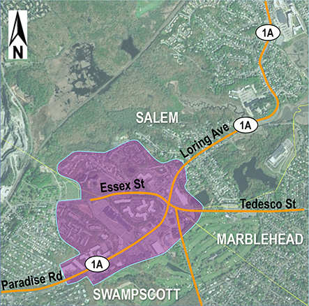
Working with the Towns of Swampscott and Marblehead and the City of Salem, the MPO selected Route 1A and other roadways in Vinnin Square as the subject of a corridor study. This location was prioritized for study because of the local interest in finding ways to improve the corridor, and because Route 1A was identified in the regional needs assessment conducted as part of the MPO’s Long-Range Transportation Plan.
Swampscott, Marblehead, and Salem envision a safe transportation network that would transform Vinnin Square into a vibrant area by linking all three communities and balancing the needs of motorists with those of pedestrians, bicyclists, and public transit riders. This vision evolved into study goals aimed at reducing congestion, increasing safety, connecting people to places, and supporting economic growth and livability. An advisory task force was formed that included representatives from all three municipalities, the Massachusetts Department of Transportation (MassDOT), and the advocacy groups WalkBoston and Mass-in-Motion.
MPO staff approached the Vinnin Square study by focusing on roadway segments, or subareas, rather than intersections. This approach allows planners to evaluate multimodal transportation needs comprehensively with the goal of creating “complete streets” that meet the needs of all roadway users. When analyzing problems and forming recommendations, the MPO staff also kept in mind the Healthy Transportation Compact, a key requirement of landmark transportation reform legislation signed into law in June 2009 that aims to facilitate transportation decisions that balance the needs of all transportation users, expand mobility, improve public health, support a cleaner environment, and create stronger communities. Ultimately, the goal is to design roadways where it is safe to cross the street and walk or cycle to shops, schools, train stations, and recreational facilities, and where buses can run on time.
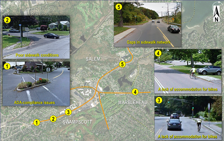
MPO staff identified problems in Vinnin Square by analyzing traffic and safety data, making site visits, and discussing issues with the advisory task force. Examples of existing issues include the following:
• Wide roadways create inequity by placing too much emphasis on vehicular use and encouraging higher vehicle speeds, putting pedestrians and bicyclists at risk
• A lack of shoulders or bike lanes makes the roadway uncomfortable for bicyclists
• Obstructions in crosswalks, non-ADA compliant curb ramps, broken sidewalks, and sidewalk gaps create an unfriendly environment for pedestrians, especially people with disabilities
• A lack of bus shelters at heavily used stops creates problems for riders, especially during inclement weather
• High vehicular speeds at the sharp horizontal curve on Route 1A at Leggs Hill Road results in many crashes
• Outdated signal-timing plans need to be updated to make the flow of traffic efficient throughout the study area
• High volumes of traffic on Route 1A and Vinnin Street create congestion at Vinnin Square and the Swampscott Mall
• Lack of turn lanes and traffic queues cause a high number of crashes on Route 1A at the Swampscott Mall, Vinnin Square, and Route 1A between Harrison Road and Sumner Road
• Numerous driveways contribute to crashes
• A lack of trees and greenery makes an unwelcoming environment for pedestrians and bicyclists
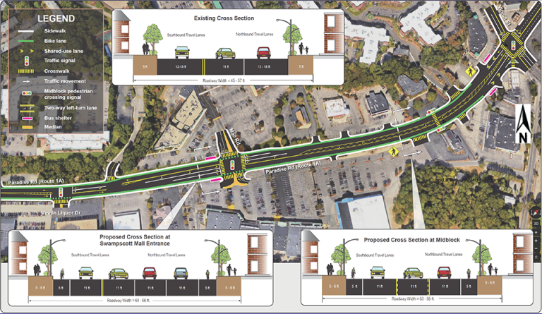
MPO staff and the advisory task force developed recommendations to target these issues and transform the study area into a pedestrian- and bicyclist-friendly transportation corridor that serves all modes of transportation and maintains regional travel capacity. Most of the recommendations could be carried out within the existing roadway’s right-of-way (i.e. they would require no land takings and take into account the needs of abutters and roadway users). A few of the proposed improvements would involve construction outside of the roadway’s right-of-way.
Proposed improvements would reconfigure roadways to add defined bike lanes or shoulders to accommodate bicyclists, revamp sidewalks and curb ramps to MassDOT’s standards, install high-visibility crosswalks, and add pedestrian signals with pushbuttons and countdown timers. Additional improvements would include retiming and coordinating the traffic signals and the installation of a two-way, left-turn lane on Route 1A at Swampscott Mall to make traffic flow efficient.
This study provides the City of Salem, Towns of Marblehead and Swampscott, MassDOT, and other stakeholders with a comprehensive and locally-driven assessment of the transportation needs at Vinnin Square and the adjoining neighborhoods, and allows them to start planning projects to implement the recommended improvements.