MBTA Rapid Transit Survey - 2008-09

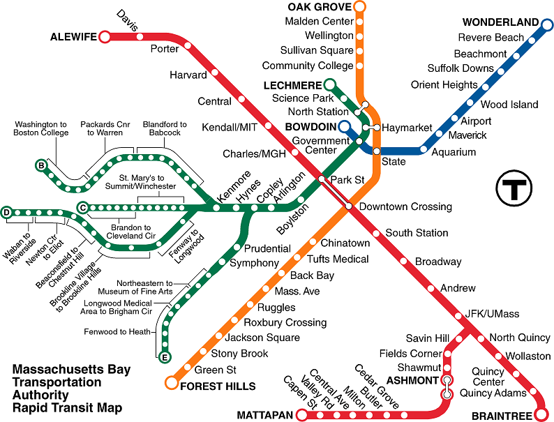
Shown on the page is the MBTA rapid transit line spider diagram showing all lines and stations not including the Silver Line. Users can click on a station name on the diagram to generate a table of survey results. Alternatively the user can select the desired station in the combo box also on the page. Seven navigable data tables will be displayed.
MBTA rapid transit spider map

Skip Image Map Navigation Links. Please disable popup blockers.

To get more information about the surveys of all transit modes conducted in 2008-09 click this link: More Info
TheT Alewife Davis Porter Harvard Central Kendall Charles Park Downtown SouthStation Broadway Andrew JFK/Umass NorthQuincy Wollaston QuincyCenter QuincyAdams Braintree SavinHill FieldsCorner Shawmut Ashmont CedarGrove Butler Milton CentralAve ValleyRd CapenStreet Mattapan Bowdoin Aquarium Maverick Airport WoodIsland OrientHeights SuffolkDowns Beachmont RevereBeach Wonderland Lechmere SciencePark NorthStation GovernmentCenter Boylston Arlington Copley HynesConventionCenter Kenmore Prudential Symphony GreenB01 GreenB02 GreenB03 GreenC01 GreenC02 GreenD01 GreenD02 GreenD03 GreenD04 GreenD05 GreenE01 GreenE02 GreenE03 OakGrove Malden Wellington Sullivan CommunityCollege Haymarket State Chinatown NewEnglandMedicalCenter BackBay MassAve Ruggles RoxburyCrossing JacksonSquare StonyBrook GreenStreet ForestHills

1. Select a transit station by clicking on a station name on the map at the left, or:
2. Choose station from box below, and click the 'Get Data' button: