Top Stories
The following public meetings were scheduled at the time TRANSREPORT was released.
For up-to-date information about others scheduled subsequently, call 857.702.3700 (voice) or 617.570.9193 (TTY).
Readers of the online issue may click on the following hyperlinks for direct links to online meeting calendars:
Boston Region MPO
MassDOT
MBTA
A photo ID is required to access most meeting sites.
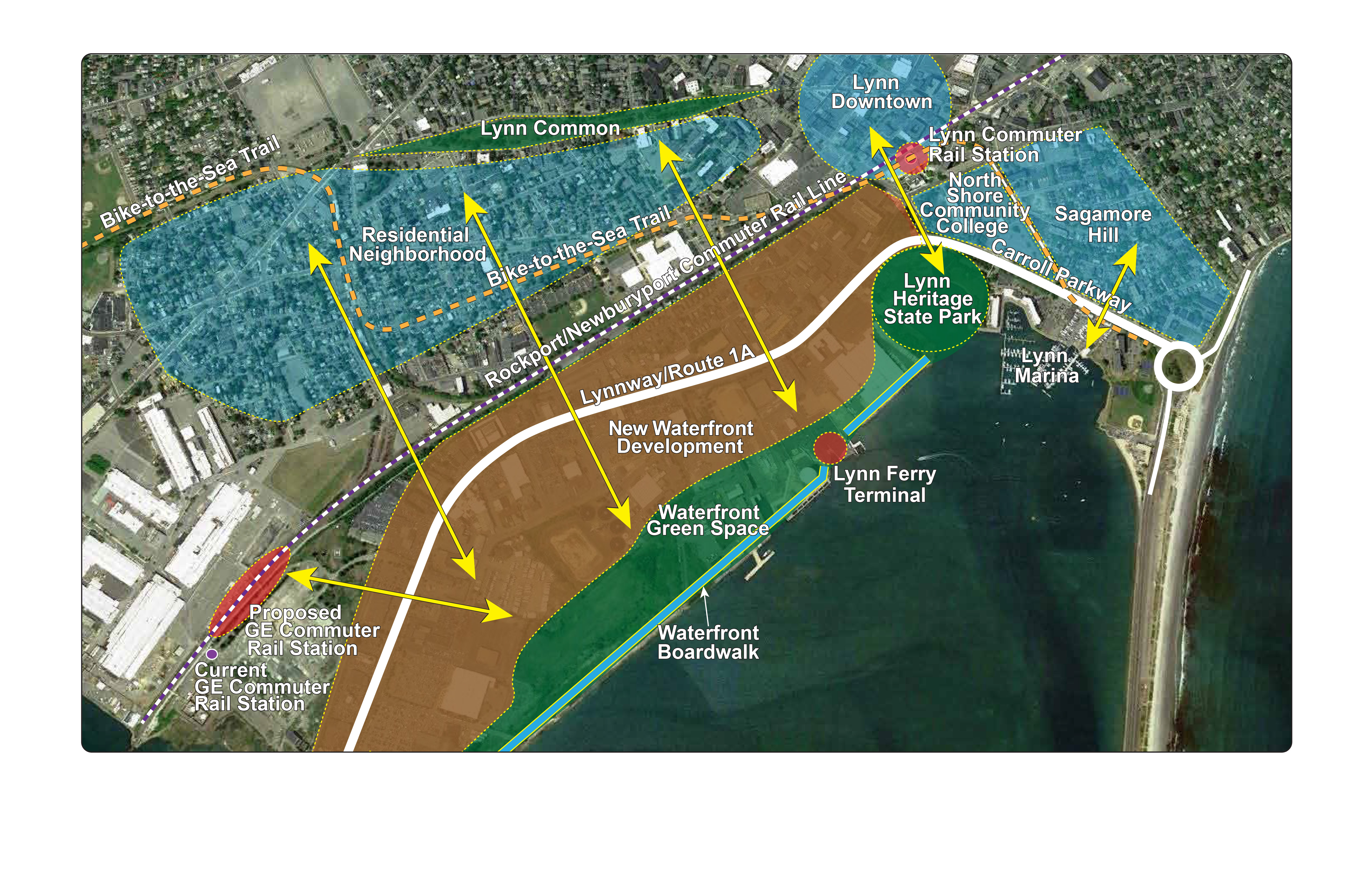
The City of Lynn has plans to redevelop 305 acres of waterfront real estate to vitalize the underutilized shoreline of Lynn Harbor with residential and commercial developments, marinas, a seaside boardwalk, and public greenspace. The parcels targeted for redevelopment are within easy walking and bicycling distance from downtown Lynn and adjacent neighborhoods, but a six-lane divided highway stands in the way and inhibits foot and bicycle traffic.
A study recently released by the Boston Region Metropolitan Planning Organization (MPO) explored ways to open up access to the waterfront by redesigning a two-mile section of the Lynnway (Route 1A) and Carroll Parkway. Doing so would make pedestrians and bicyclists feel comfortable using the corridor, and would better incorporate transit services in the corridor, while maintaining capacity for motor traffic.
The MPO staff, working with stakeholders on an advisory task force, identified a number of safety and traffic operations issues in the high-speed traffic corridor. Challenges for pedestrians include long crosswalks across the wide roadway, inadequate median refuge areas, and obstructed crosswalks. Bicyclists face unsafe conditions as there are no roadway shoulders or bicycle lanes. The corridor experiences a high number of vehicular crashes with 241 crashes occurring in a two-year period, two of which resulted in fatalities.
The study recommended several short-term measures to improve safety, access to the waterfront, and traffic operations. These include retiming and coordinating signals, opening the roadway median to provide pedestrian access to the ferry terminal on Blossom Street, creating shared-use lanes, and making improvements for the safety of pedestrians with disabilities, in compliance with the Americans with Disabilities Act.
Five alternative designs were also presented as long-term solutions. They include a “complete street” design that would reduce auto lanes to make way for a separated bicycle lane; a boulevard- style design that would incorporate a wide median; a plan for pedestrian bridges at several locations over the roadway, which would provide access to the waterfront from residential areas; and a design that would incorporate bus rapid transit (BRT) in the median. The concept of altering the traffic circulation on the Carroll Parkway to separate northbound and southbound traffic was also explored; however, doing so would have severe impacts on traffic flow.
Read the Route 1A/Lynnway/Carroll Parkway Study on the MPO’s website (http://www.bostonmpo.org/2015_priority_corridors.)
The plan to extend Green Line light rail service to Somerville and Medford is getting back on track after the project stalled last year because of significant cost overruns, a setback that inflated the cost estimate from nearly $2 billion to as much as $3 billion and caused the state to put construction on hold and re-evaluate the project design, procurement, management, and funding.
In the wake of these cost escalations, the MassDOT Board of Directors and the MBTA’s Fiscal and Management Control Board (FMCB), now overseeing the project, assigned an interim project management team to redesign the project by scaling back design elements to reduce costs while maintaining the anticipated benefits and functionality of the original project concept.
The team presented its findings to the boards this spring and offered various means to save costs, including minimizing the use of retaining walls (which would affect the design of the Community Path bicycle trail that would run along the new Green Line corridor), building open-air stations rather than enclosed ones, and constructing a smaller vehicle maintenance facility.
The pared-down design was presented as a starting point for working out the details of the design work going forward. In May, the joint boards voted to take next steps to advance the scaled-back project. The decision to recommit to the project’s advancement was bolstered by financial commitments to the project made by the Boston Region MPO, the Cities of Somerville and Cambridge, and developers with interests in the new Green Line corridor. The MPO’s commitment will ultimately leverage $190 million in funding ($152 million of the MPO’s federal discretionary funding and $38 million in matching funds from local contributions). The cities and developers have pledged $75 million.
The MassDOT Board and FMCB are now engaging with the Federal Transit Administration (FTA), which holds the purse strings of a nearly $996 million federal New Starts grant awarded to the Commonwealth for the Green Line Extension. (Access to those grant monies remains frozen since the project was paused.) Under the Commonwealth’s original agreement with FTA, that grant would be matched by approximately $1 billion of Commonwealth funds.
The MPO’s $190 million commitment is a reallocation of monies that were previously devoted to a future second phase of the extension of the Green Line. The first phase would extend the Green Line from Lechmere Station in Cambridge through Somerville to end at College Avenue in Medford, near Tufts University; the second phase would extend the line from the College Avenue Station to a terminal station at Route 16 (Mystic Valley Parkway) in Medford.
During public discussions that aired at the MPO meetings this spring, MPO members heard testimony from many supporters of the Green Line Extension project. Municipal leaders and legislators representing the communities in the new Green Line corridor were among those advocating for the MPO’s continued commitment to construct a station at Route 16. Supporters have cited the economic development potential in the corridor, the opportunities to build new housing and provide transit access to jobs, and air quality and health benefits that would come from reducing auto usage and enhancing bicycle and pedestrian connections to transit service.
In response to the sustained interest in the full extension to Route 16, MassDOT made a commitment to the MPO to begin the environmental review process for the second phase by the end of calendar year 2016, and to carry out the Massachusetts Environmental Protection Act (MEPA) process through to the completion of a Final Environmental Impact Report, as long as the first phase of the project continues to advance. With this assurance, the MPO voted unanimously on June 16 to approve the transfer of funds from the second phase to the first phase, as documented in Amendment Four of the FFYs 2016-20 Transportation Improvement Program (TIP).
One final action remains for the MPO to formalize the decision: the changes must be incorporated into the Long-Range Transportation Plan (LRTP), Charting Progress to 2040. The details are available in the proposed Amendment One to the LRTP, which is now available for public review.
Next Story • Previous Story • Back to Top
The Boston Region MPO recently gave approval for its staff, the Central Transportation Planning Staff (CTPS), to begin work on two projects under contract with the MBTA. Both projects will assist the MBTA with its required reporting to the Federal Transit Administration (FTA).
As a recipient of federal funds, the MBTA must, in compliance with Title VI of the Civil Rights Act of 1964, demonstrate that it provides a comparable level and quality of transportation service to all customers without discriminating by race, color, or national origin. CTPS will assist the MBTA in this endeavor by supporting the development of the MBTA’s 2017 Triennial Title VI Report.
The MBTA must also regularly report transit ridership data to FTA’s National Transit Database, a repository of information and statistics about US transit systems that receive federal grants. As it has done regularly in the past, CTPS will assist the MBTA with this requirement by collecting current data on passenger boardings and estimating passenger-miles travelled on the MBTA’s bus, rapid transit, and commuter rail services.
At AACT’s meeting on May 25, Ed Carr, Administrator of the MetroWest Regional Transit Authority (MWRTA), discussed the process for transferring responsibility over the local paratransit services in Wellesley, Weston, and Dover from the MBTA to the MWRTA. As of July 1, MWRTA has assumed direct responsibility for providing Americans with Disabilities Act (ADA)-required paratransit service to the towns of Dover and Wellesley. The Town of Weston subsequently elected to continue receiving paratransit service from the MBTA for the time being. The MBTA will be working with Weston over the next few weeks to develop a plan for maintaining transportation options to and from Weston locations and its bordering communities, while also moving the MBTA RIDE service toward a sustainable business model.
The Advisory Council has begun a series of conversations about how the region’s transit system can evolve to meet the needs of residents in a time of changing commuter travel preferences and new technologies. In June, the Council heard a presentation about current MBTA technology initiatives designed to improve transit service. At the next meeting, which will take place at the State Transportation Building on August 10 at 3:00 PM, the discussion will focus on MassDOT’s planning for autonomous vehicles. Members of the public are welcome to attend.
The Advisory Council will not formally convene in July. On July 13, members are scheduled to visit the Commuter Rail Maintenance Facility in Somerville. For more information or to sign up for the field trip, please contact David Fargen at 857-702-3654 or dfargen@ctps.org
Next Story • Previous
Story • Back to Top
The Boston Region MPO has released several transportation planning documents for public review. Below is a synopsis of each document and their public review periods.
The MPO staff will host “Office Hours” at the State Transportation Building the afternoon and evening of July 18 and 21 to discuss these draft documents, answer questions, and hear comments from members of the public. Please join us for one-on-one conversations. (See the Calendar for meeting times and locations.)
The Transportation Improvement Program (TIP) is a five-year plan for financing the
construction and implementation of highway and transit projects and programs in the region. Approved TIPs are amended, as needed, throughout the year to reflect changes to project costs and schedules and to make other adjustments to project programming.
Amendment Five would update project costs and add new projects and programs that would be implemented between federal fiscal years (FFYs) 2016 and 2020. The public review
period for Amendment Five remains open until July 25. The MPO is scheduled to vote on
the amendment on July 28.
The new TIP programs funding for projects to be implemented in the years FFY 2017 through 2021. They include multiyear projects that continue from the FFY 2016-20 TIP and new projects selected to receive funding over the next five years.
The new projects will receive MPO discretionary funding according to how well they meet the MPO’s project evaluation criteria, their readiness for construction in TIP timeframe, and whether their costs are containable within the fiscal limits of this TIP.
New proposed projects are as follows:
The public comment period for the TIP remains open until July 25. The MPO is scheduled to vote to endorse the TIP on July 28.
The MPO’s Long-Range Transportation Plan (LRTP), Charting Progress to 2040, documents regionally significant projects and investment programs planned out over a 25-year timeline. For planning purposes, regionally significant projects are considered to be those that either will add capacity to the transportation system or that cost more than $20 million. Projects programmed in the LRTP are ultimately programmed through the TIP when they are within five years of implementation.
The primary reason for Amendment One is to make the LRTP consistent with the FFYs 2016–20 TIP and its amendments, the proposed FFYs 2017–21 TIP, and the Massachusetts Capital
Investment Program (CIP). The CIP documents projects prioritized by the state.
Amendment One would accomplish the following:
The public comment period for Amendment One remains open until August 10. The MPO is scheduled to vote to endorse the document at their meeting on August 18.
The MPO produces a Unified Planning Work Program (UPWP) each year. The UPWP documents the transportation-planning studies and other MPO planning and administrative activities that will be conducted in the coming federal fiscal year, as well as their costs and funding sources. The following new studies and technical analyses are proposed for FFY 2017:
The public comment period for the UPWP remains open until July 18. The MPO is scheduled to vote to endorse the document at their meeting on July 28.
For more information and to view the documents, visit the MPO’s website at www.bostonmpo.org. Online readers may use the direct links below:
TIP Amendment Five
FFYs 2017-21 TIP
LRTP Amendment One
FFY 2017 UPWP
Click Here to Comment
Comments may be submitted through the MPO’s online comment form or via mail, email, fax, or phone:
Boston Region Metropolitan Planning Organization
State Transportation Building
10 Park Plaza, Suite 2150
Boston, MA 02116-3968
Next Story • Previous
Story • Back to Top
Whether you’re walking, driving, or taking the train, it’s never been easier to get around the Commonwealth thanks to the newest Official Massachusetts Transportation map. Both long-time Bay Staters and first time visitors can make use of the transportation and tourist information provided by this easy-to-read resource.
An update to the previous 2012 version, the new map depicts ten additional shared use paths and the latest MBTA Commuter Rail and Rapid Transit map. Thirty-seven points of interest are also highlighted in the Downtown Boston area, from the Museum of Science to the TD Garden.
Digital versions of the map, available in four languages, can be found on the Official Massachusetts Transportation Map webpage (https://www.massdot.state.ma.us/highway/TrafficTravelResources/OfficialTransportationMap.aspx.)
You may request a free print copy of the map through the aforementioned webpage.
Image:MassDOT
The members of the Boston Region MPO are: Massachusetts Department of Transportation, Cities of Beverly, Boston, Everett, Newton, Somerville, and Woburn, Federal Highway Administration, Federal Transit Administration, Massachusetts Bay Transportation Authority, Massachusetts Bay Transportation Authority Advisory Board, Massachusetts Port Authority, Metropolitan Area Planning Council, Regional Transportation Advisory Council, Towns of Arlington, Bedford, Braintree, Framingham, Lexington, Medway, and Norwood.