
Technical Memorandum
DATE: July 18, 2019
TO: Boston Region Metropolitan Planning Organization
FROM: Bill Kuttner
RE: Boston Region MPO Freight Planning Action Plan Update
The Boston Region Metropolitan Planning Organization (MPO) freight program began in federal fiscal year (FFY) 2014 and has been funded annually on a regular basis since its inception. The broad outlines of the MPO freight program were presented in the 2013 Freight Planning Action Plan. 1 The Freight Planning Action Plan outlined five broad goals of potential MPO freight planning activities that will
These five goals are preserved for this action plan update. These goals are wide-ranging and each goal is important to the MPO planning process and important for a full understanding of regional freight, logistics, and associated economic issues. Freight program funding alone would not be enough to understand regional freight and associated heavy vehicle traffic.
Fortunately, much of the freight-related knowledge and insights are developed as part of MPO efforts funded outside the MPO freight program. The staff and information resources associated with the MPO freight program centralize freight knowledge, allowing information to be gathered from throughout the Boston region and applied to any MPO planning activity. The freight program funding can be focused on issues that are not yet prominent enough to generate their own funding sources.
This memorandum begins by reviewing studies and freight planning activities undertaken since the MPO freight program was established. To start, short descriptions of the five publications funded by the MPO freight program are included. These publications are described first because other freight planning activities resulted directly from these completed studies. Next, descriptions of work that did not result in publications are included and also freight-related work funded by other programs or agencies. The memorandum concludes by describing potential study topics and planning activities that the freight program is likely to work on in the next several years.
The 2013 Freight Planning Action Plan briefly described a number of freight-related issues covering different modes and jurisdictional responsibilities. Each FFY, a topic that could be addressed in a clearly defined study was presented to the MPO as a task in a work scope for freight planning support. These studies and complementary website abstracts are presented in this section.
Most of the freight planning work undertaken by the MPO involves the use of trucks including heavy vehicles not carrying freight; for example, dump trucks. The two main reasons for this is that the majority of freight travels by truck, and the MPO has primary responsibility for investment decisions in the most important parts of the road system.
However, this does not mean that the other modes of transportation are ignored. Rather, because goods traveling by other modes must at some point be transferred to or from a truck, trucks can help serve as a lens for understanding other modes. For instance, important data of Massport’s Paul W. Conley Container Terminal in South Boston can be understood by counting and mapping the distribution of truck movements between the terminal and points in New England.
After the publication of the 2013 Freight Planning Action Plan, five of the recommended studies were completed and published. A brief discussion of each study is included below.
Improving Truck Travel in the Everett-Chelsea Industrial Area
January 2016
https://www.bostonmpo.org/truck-travel-everett-chelsea
The cities of Everett and Chelsea have long-established industrial areas along the northern reaches of Boston’s inner harbor. These areas include important parts of the working waterfront as well as numerous industrial sites extending inland from the waterfront. The uses of these sites have evolved and now include numerous non-industrial activities. There is ongoing investment in both industrial and non-industrial activities.
The roadway system in this area is in very poor condition. Many trucks are forced to take circuitous routes to their industrial destinations, resulting in unnecessary truck traffic in more residential and commercial areas. This study analyzes the volume and routes of truck traffic in the area and makes recommendations to modify the road network to improve truck access to industrial areas and reduce truck impacts to non-industrial areas.
Rest Locations for Long-Distance Truck Drivers in Massachusetts
October 2016
https://www.bostonmpo.org/rest-locations-truck-drivers
Rest locations for long-distance truck drivers are a critical component of the nation’s freight transportation system. Freight transportation by truck continues to grow, and enforcement of driver rest requirements is becoming more rigorous. These trends have resulted in the inadequacy of truck rest locations being acknowledged as a national problem. Federal legislation encourages states and MPOs to address this issue in state and local freight planning. This study
Trucks in the South Boston Waterfront
April 2017
https://www.bostonmpo.org/trucks-south-boston-waterfront
Transportation in the South Boston Waterfront area has been studied extensively in recent years, principally from the perspective of accommodating strong growth in residential and non-industrial commercial activities. Industrial and port-related activities continue in this area, some of which are being expanded or modernized through the use of public or private funding.
The transportation needs associated with industrial and seaport activities have always been acknowledged but they have been analyzed largely as part of the overall traffic management problem. This study complements previous studies while focusing primarily on trucks and heavy vehicles. Transportation issues addressed in this study include:
Weight and Height Restrictions that Impact Truck Travel
December 2017
https://www.bostonmpo.org/weight-height-restrictions-truck-travel
Numerous bridges in the Boston MPO area have weight or height restrictions that preclude the use of a roadway by trucks exceeding the limit. These bridges may be in sound physical condition, but built to different standards. The purpose of this study is to identify the locations of restricted bridges and estimate the impact that these bridges pose to regional truck movements. These estimates are largely qualitative, focusing on the types of trucks, industries, and shipments most likely to be inconvenienced by a bridge restriction.
The study reviews the regulations governing road use by large vehicles and sign placement by operating authorities. Specific locations with restrictions are listed and mapped. Crash data are presented for bridges with height restrictions, and opportunities to incorporate these data into MPO project evaluations are also identified.
Intermodal Warehouses in Massachusetts
October 2018
https://www.bostonmpo.org/intermodal-warehouses
Trucks are the dominant freight transportation mode in Massachusetts. While significant quantities of freight also travel by rail, air, or ocean, freight movements by these other modes almost always involve travel via truck at some point in the journey. A wide variety of specialized terminals have been developed to facilitate and optimize freight movements using multiple modes. This memorandum discusses one specific type of facility, the intermodal warehouse.
The facilities described in this study share two characteristics. First, in addition to truck loading bays, they all have a rail siding allowing boxcar freight to be delivered directly to the warehouse. Second, they can provide customers with a range of value-added logistic services. Most of these services involve some aspect of inventory management, but can also include pickup and delivery or import and export permitting. Typically, an intermodal warehouse is considered a business partner of a railroad.
This study identifies 10 intermodal warehouses operating in Massachusetts. The railroad services, logistic emphases, and land use implications of these operations are described and illustrated graphically.
The Everett-Chelsea and South Boston Waterfront studies were used to identify specific sections of urban roadway that were designated as Critical Urban Freight Corridors (CUFCs). The designation of CUFCs was mandated by the current federal funding authorization, Fixing America’s Surface Transportation (more commonly known as FAST) Act.
As part of the MPO freight program, these specific sections and other urban roadways either directly serving or connecting locations of industrial and logistic importance were designated as CUFCs, and as a result, have been incorporated into the National Highway Freight Network. Several of these locations are also candidates for inclusion in the MPO’s Transportation Improvement Plan (TIP) or the LRTP, and the CUFC designation is positive for inclusion in these planning documents.
A new rest location on the northwest arc of Interstate 495, a key recommendation of the truck rest locations study, was incorporated into MassDOT’s Massachusetts Freight Plan.2 Another result of this study was two invitations to serve on both a federal and a state working group. The working group sponsored by the Federal Highway Administration (FHWA) aimed to look at the problem of expanding the supply of truck parking for drivers to get their mandatory rest breaks. The state working group was looking at roadway safety improvements in general. Finally, the Environmental Protection Agency invited MPO freight program staff to present at a conference on technologies and issues for lessening the environmental impacts of commercial truck stops.
The findings of the weight and height restrictions memorandum have been coded into the MPO’s travel demand model. The findings have also been reviewed in the prioritization of projects for inclusion in the TIP and LRTP planning documents.
Implicit in the MPO’s freight program is outreach to industry, government, and public stakeholders. Freight program staff regularly presents to the MPO’s Regional Transportation Advisory Council and has also participated with MassDOT’s freight advisory council, which was convened to advise MassDOT in the preparation of the state freight plan. The highway safety working groups and occasional trade association meetings have also been opportunities to meet stakeholders in the motor carrier and rail industries
Meeting with freight planning professionals presents another opportunity to share work, receive feedback and new ideas. Freight program staff also served on a topic panel for a Federal Aviation Administration sponsored study on estimating truck trip generation at airport air cargo facilities.3 This experience provided some alternative study approaches to look at the growing air cargo industry in the Boston region.
It can be challenging to get enough data to improve model estimation procedures. Topical studies such as the Everett-Chelsea and South Boston Waterfront studies generate sets of detailed and accurate truck travel data focused on areas of freight and general planning interest.
However, the relevant geography of freight logistics is extensive, more so than the patterns of commuting trips. Only with the recent adoption of a statewide travel demand model for use in MPO planning, have locations such as distribution centers for major supermarket and building supply chains been represented in the MPO’s travel demand model.
Classification counts based on tubes or other types of sensors are often unreliable. The gold standard for vehicle classification is toll reports. In 2016, it was still possible to obtain data by vehicle type from the former Turnpike’s toll plaza-to-toll plaza ticket system between the New York state line and Interchange 15 at I-95/Route 128.
Freight program staff has developed heavy vehicle data for all the toll systems in Massachusetts and New Hampshire. It was also possible to apply big data analysis techniques to add valuable detail to the toll reports. Together with carefully vetted truck counts from other studies, the MPO’s freight program and model development staff now believe that freight model improvement efforts can be productive.
Incorporating newly obtained heavy vehicle data into the model development process requires a fresh look and simplification of the model estimation process. A set of recommended freight and truck modeling approaches has been compiled by the FHWA.4 Freight program staff has recommended an approach that focuses on heavy vehicles, rather than simply freight, reflecting a common concern in urban roadway planning. Heavy vehicle trip generation estimates have been developed using federally mandated ES-202 town-level employment and wage reports.
Outreach, data collection, and model development efforts are expected to continue as described above, with the model development efforts perhaps accelerating. This section presents possible study topics and analysis activities that might be appropriate over the next several years. These topics have been organized into two broad groups. The first group includes topics somehow related to the newly designated system of CUFCs. Any other potential study topics are presented in the second group. The potential study topics include ideas that could become full studies, smaller topics of interest, and topics for which a study might be funded as part of a major effort by a different program or agency.
The Everett-Chelsea study analyzed truck traffic on Second and Beacham Streets (Figure 1). The findings justified designation of these streets as CUFCs, and were used to support Everett’s funding applications.
The CUFC continues along Route 99, crosses the Mystic River, and connects with I-93 as it passes through Charlestown on Rutherford Avenue to reach Cambridge. Massport owns the Moran Terminal and has expressed an interest in better understanding truck flows associated with Autoport, Moran’s industrial tenant. Also, consulting firms under contract with the City of Boston have expressed interest in seeing truck movements in this area analyzed at a level of detail similar to that of the Everett-Chelsea study. With expressed interest from two MPO members, this work was approved by the MPO board for FFY 2019.
Figure 1
Everett-Chelsea Industrial Area and Charlestown
Red: Recently adopted Critical Urban Freight Corridors
Purple: Previously defined National Highway Freight Network elements
Green: Other MPO travel demand model roadways
Source: Central Transportation Planning Staff.
Figure 2 shows the eastern terminus of I-90 in East Boston. I-90 and some of the Logan Airport circulation roadways are part of the National Highway Freight Network. The Coughlin Bypass Road, newly designated as a CUFC, connects I-90 and Logan Airport with the Chelsea River and the CUFC system leading to Charlestown. Many of the roadways in Figure 2 are critical for the efficient operations of New England’s air freight system, a complex, interconnected system of consolidation and distribution facilities located throughout eastern Massachusetts, only some of which are located at Logan Airport.
This update envisions developing a profile at some point of the regional off-airport airfreight system. This airfreight system connects eastern Massachusetts with the entire world, at least with respect to physical goods.
Figure 2
East Boston Haul Road to the Mystic River

Red: Recently adopted Critical Urban Freight Corridors
Purple: Previously defined National Highway Freight Network elements
Green: Other MPO travel demand model roadways
Source: Central Transportation Planning Staff.
Figure 3 shows the western end of this CUFC system, where traffic on the one-way roadway pair of River Street and Western Avenue allows trucks and general traffic to connect with I-90 in Allston. The Allston interchange will be completely reconstructed over a period of several years. This will entail both traffic disruption on I-90 and a large number of trucks supporting the construction itself.
Regional stakeholders have suggested studying these impacts as a freight program topic. However, study of construction-phase truck impacts might be funded as part of the project itself. The MPO freight program could look at truck movements in this area as a separate freight program study topic and establish a truck activity baseline upon which construction-phase freight planning might be based.
Figure 3
Charlestown to the Turnpike

Red: Recently adopted Critical Urban Freight Corridors
Purple: Previously defined National Highway Freight Network elements
Green: Other MPO travel demand model roadways
Source: Central Transportation Planning Staff.
Figure 4 shows the CUFC system connecting the South Boston Waterfront with I‑93, the Southeast Expressway. The South Boston Waterfront study gave an overview of some of the congestion and truck flow issues in this area. Some of these issues are likely to be more closely studied, especially with respect to trucks. Freight program staff have directly supported MassDOT’s work in the past at MassDOT project expense, and similar efforts may be appropriate. However, follow-up work for MassDOT might not warrant a full report.
There might be an opportunity for a full MPO freight program study in this area. The Southeast Expressway is the most extensive and severe bottleneck in the region, and several conceptual plans and feasibility studies have explored ways of adding capacity in this corridor. Congestion in this corridor impacts all traffic, but the impacts on trucks, and more specifically the impact on the truck-dependent industries served through Interchange 18 in Newmarket, Widett Circle, and the South Boston Waterfront, have not been fully quantified.
Figure 4
South Boston Waterfront
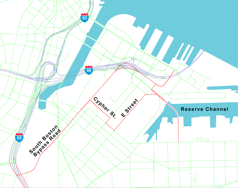
Red: Recently adopted Critical Urban Freight Corridors
Purple: Previously defined National Highway Freight Network elements
Green: Other MPO travel demand model roadways
Source: Central Transportation Planning Staff.
The need for more rest locations for long-distance truck drivers is now broadly acknowledged and some of the practicalities for locating and configuring additional truck parking capacity were described in the rest location study. Possible locations for expanded truck parking may be outside of the Boston MPO area, and it is assumed that MassDOT would initiate planning efforts. MPO freight program staff will be available to support any planning activities in this area.
An opportunity for a free-standing MPO study might be to develop a conceptual plan for a new commercial truck stop that would include any currently available impact-reducing technologies. This could be an abstract location or a case study conceived around a specific site. A study of this nature would require close consultation with MassDOT. The purpose of the study would be to facilitate discussions with local and regional stakeholders to determine how the problem of adequate truck rest locations might be appropriately addressed.
Regional logistic patterns are geographically extensive. The Conley Container Terminal is located within the Boston MPO area, but gate survey conducted as part of the South Boston Waterfront study showed that containers from this terminal were distributed throughout New England. These data have been shared with the Port Authority of New York and New Jersey, and results of a similar study they are undertaking will soon be available to the Boston Region MPO.
Logan Airport is also centrally located within the Boston region, however, it is anticipated that any analysis of air freight movements in or out of Logan Airport will also reveal a New England-wide impact. Reliable data such as these are not only valued input into the model development process, but they are also the basis for informed decision-making by the MPO and its partners.
The intermodal terminal in Worcester operated by the CSX railroad has been greatly expanded within the last decade and now handles the container and trailer transfers between truck and rail that were previously performed at the rail yard adjacent to the I-90 interchange in Allston. A substantial number of truckloads using this terminal began or ended journeys at some point within the Boston MPO area. The numbers, locations, and times of these movements are not known, but could be revealed with a gate survey similar to one performed at the Conley Terminal in South Boston.
Truck model development is not a responsibility of the MPO freight program, but it is an important goal that has the potential to add an important dimension to the MPO planning process. The Freight Action Plan update envisions using improved truck modeling capabilities in the preparation of topical studies.
The proposed study of trucks using the congested Southeast Expressway at the Interchange 18 urban industrial nexus illustrates some of the possibilities of using an improved truck model. The study would observe where, when, how many, and the types of trucks that are forced through the various parts of this congested roadway subsystem. License plate or driver surveys would not be used in this study. However, the regional travel demand model could give a rough estimate of the regional flows of impacted heavy vehicles. If the problems in this area evolve into actual projects, more detailed truck flow work could be performed as part of project budgets.
The 2013 Freight Planning Action Plan presented overall goals of the freight program and explained the reasoning behind giving trucks and heavy vehicles a high priority. On a day-to-day basis, freight program activities fall into three general areas: MPO support, stakeholder outreach, and topical studies. This update recommends that the initial goals and the standard freight program activities continue.
However, the freight program work going forward can build on previous studies and freight-related work. The designation of CUFCs brings to the forefront hot spots that might be studied, including:
The successful gate survey at Conley Container Terminal suggests follow-up intermodal investigations, including:
The truck rest location study puts the MPO in the middle of a national problem, and MPO staff will continue to be involved in active working groups.
This update has noted various freight, truck, and heavy vehicle issues regardless of size or institutional interest. Some of these issues may become the basis of topical studies specified in annual work programs presented for approval by the MPO. Study topics that are particularly timely or generate substantial stakeholder interest can be addressed sooner than other topics. Smaller issues may be addressed separately as part of ongoing MPO support. Some proponents of major projects will seek out and fund MPO freight program staff participation, analyzing the implications for major projects on the freight system.
Data acquisition also builds on earlier efforts. Traffic volumes evolve and reliably obtained heavy vehicle counts should be considered usable for a number of years after development. With each topical study or identification of a reliable new data source, the collection of useful freight data increases. There is now an opportunity to address improving the truck component of the regional travel demand model. Using improved model-generated estimates to help interpret results obtained in the field during topical studies can add a new dimension to MPO freight analysis in the years to come.
Outreach efforts to MPO members and other stakeholders will continue. There have been an increasing number of opportunities to share the MPO’s work with the public. The challenge has long been, and continues to be, cultivating the involvement of shippers and carriers who, understandably, spend most of their time and efforts running their businesses. Freight program staff are aware of this challenge and opportunities to engage businesses are always welcome.
1 Proposed Freight Planning Action Plan for the Boston Region MPO: Meeting the Goals and Addressing the Issues, Boston Region MPO, September 2013. https://www.bostonmpo.org/Drupal/freight_action.
2 Massachusetts Department of Transportation, Massachusetts Freight Plan, April 2018, pages 5-75. https://www.mass.gov/files/documents/2018/09/04/Freight%20Plan508.pdf.
3 Airport Cooperative Research Program, Synthesis 80: Estimating Truck Trip Generation for Airport Air Cargo Activity, 2017.
4 Federal Highway Administration, publication number FHWA-HOP-08-010: Quick Response Freight Manual II, September 2007.