Route 203 (Gallivan Boulevard and Morton Street): Safety, Mobility, and Access Management
Project Manager
Seth Asante
Project Principal
Efi Pagitsas
Data Analysts
Seth Asante
Kathy Jacob
Graphics
Kenneth Dumas
Kim Noonan
Jane Gillis
Cover Design
Kim Noonan
The preparation of this document was funded by the
Massachusetts Department of Transportation.
Central Transportation Planning Staff
Directed by the Boston Region Metropolitan
Planning Organization. The MPO is composed of
state and regional agencies and authorities, and
local governments.
November 2012
To request additional copies of this document or
copies in an accessible format, contact:
Central Transportation Planning Staff
State Transportation Building
Ten Park Plaza, Suite 2150
Boston, Massachusetts 02116
(617) 973-7100
(617) 973-8855 (fax)
(617) 973-7089 (TTY)
ctps@ctps.org
www.bostonmpo.org
The arterial segment of Route 203 between Gallivan Boulevard and Morton Street was selected for study as part of a larger study, Priority Corridors for the Long-Range Transportation Plan (LRTP) Needs Assessment. Route 203 was chosen because it is one of the MassDOT Highway Division’s District 6 high-priority corridors needing improvement. The jurisdiction for this roadway was recently transferred from the Department of Conservation and Recreation to the Massachusetts Department of Transportation (MassDOT). MassDOT is working with the City of Boston and local stakeholders to try to obtain funding for a roadway improvement project.
This study identified several problems in the corridor, including safety for pedestrians, bicyclists, and motorists, noncompliance with the Americans with Disabilities Act, inadequate accommodation of bicyclists and pedestrians, poor pavement condition, outdated traffic signal equipment, outdated traffic signal timing and phase plans, and a need to make access to transit services safer.
Working with representatives from MassDOT and the City of Boston, MPO staff developed several recommendations for increasing safety, improving access, and making traffic operations more efficient. If the recommendations are implemented, the result would be an improved roadway corridor, where it is safe to cross the street and walk or cycle to shops or schools, where buses can run on time, where it is safe for people to walk to and from train stations, and where it is safer for motorists.
We wish to thank the Massachusetts Department of Transportation’s Highway Division and Office of Transportation Planning and the City of Boston for participating in this study and supplying us with data and other information. We also thank all those who participated in this study through meetings, feedback, and reviews.
S.1.1 Pedestrian and Bicycle Accommodation Problems
2 Data Collection and Scope of Analysis
2.1.1 Vehicle, Pedestrian, and Bicycle Counts
2.1.2 Traffic Signal Information
2.2.1 Traffic Operations Analysis
2.2.3 Transit Service Analysis
3.2 Conditions in the Gallivan Boulevard and Morton Street Segments
3.2.1 Traffic, Pedestrian, and Bicycle Volumes
3.2.2 Sidewalks and Crosswalks
3.3 Identified Problems: Arterial Segments
3.3.1 Gallivan Boulevard Segment
3.3.1 Gallivan Boulevard and Granite Avenue/Adams Street
Pedestrian and Bicyclist Amenities
Level of Service, Delay, and Queues
3.3.2 Gallivan Boulevard and Dorchester Avenue
Pedestrian and Bicycle Amenities
Level of Service, Delay, and Queues
3.3.3 Gallivan Boulevard and Washington Street
Pedestrian and Bicycle Amenities
Level of Service, Delay, and Queues
3.3.4 Morton Street and West Selden Street/Selden Street/Corbet Street
Level of Service, Delay, and Queues
Pedestrian and Bicycle Amenities
Level of Service, Delay, and Queues
3.3.6 Morton Street and Blue Hill Avenue
Pedestrian and Bicycle Amenities
Level of Service, Delay, and Queues
3.3.7 Morton Street at Courtland Road and Havelock Street
Pedestrian and Bicycle Amenities
Level of Service, Delay, and Queues
4.1 Planned and Proposed Projects
4.1.1 Morton Street over the MBTA and CSX Railroad Tracks (MassDOT project #603654)
4.2.2 Projected Traffic Volumes and Levels of Service
4.3.1 Gallivan Boulevard Segment
Pedestrian Facilities Improvements
Roadway Reconfiguration (Road Diet)
Traffic Signal Equipment and Infrastructure Upgrade
Traffic Signal Retiming and Coordination Update
Pavement and Drainage Rehabilitation
Bus Transit Service Improvements
Pedestrian Facilities Improvements
Traffic Signal Equipment and Infrastructure Upgrade
Traffic Signal Retiming and Coordination Update
Medians and Landscaping Upgrade
Pavement and Drainage Rehabilitation
Bus Transit Service Improvements
Gallivan Boulevard at Granite Avenue/Adams Street
Gallivan Boulevard at Dorchester Avenue
Gallivan Boulevard at Washington Street
Morton Street at West Selden Street/Selden Street/Corbet Street
Morton Street from Lucerne Street/Leston Street to Wildwood Street
Morton Street at Blue Hill Avenue
Morton Street at Havelock Street and Courtland Road
(Separately bound, available upon request)
A Traffic Counts
A.1 Vehicle, Pedestrian, and Bicycle Counts
A.2 Automatic Traffic Recorder Counts
B Signal Timing Information
C Crash Data and Analysis
C.1 Crash Rates
C.2 Crash Data and Collision Diagrams
D Spot Speed Data
E Intersection Capacity Analysis
E.1 Existing Conditions
E.2 2020 without Improvements
E.3 2020 with Improvements
E.4 2020 with Road Diet
| Figure |
|
|
|---|---|---|
3-1 |
Study Area |
|
3-2 |
Turning-Movement and Automatic Traffic Recorder Counts |
|
3-3 |
Pavement Condition |
|
3-4 |
Travel Speeds on Route 203: AM Peak Period |
|
3-5 |
Travel Speeds on Route 203: PM Peak Period |
|
3-6 |
Transit Services |
|
4-1 |
Turning-Movement Counts for 2020 Peak Hour |
|
4-2 |
Proposed Improvements: Gallivan Boulevard Segment |
|
4-3 |
Proposed Improvements: Morton Street Segment |
|
4-4 |
Proposed Improvements at the Intersection of Gallivan Boulevard, Granite Avenue, and Adams Street |
|
4-5 |
Proposed Improvements at Gallivan Boulevard and Dorchester Avenue Intersection |
|
4-6 |
Proposed Improvements for Gallivan Boulevard and Washington Street Intersection-Option 1 |
|
4-7 |
Proposed Improvements for Gallivan Boulevard and Washington Street Intersection-Option 2 |
|
4-8 |
Proposed Improvements at the Intersection of Morton Street, West Selden Street, Corbet Street, and Selden Street |
|
4-9 |
Proposed Improvements at Morton Street: Between Wildwood Street and Lucerne Street |
|
4-10 |
Proposed Improvements for Morton Street and Blue Hill Intersection |
|
4-11 |
Proposed Improvements at the Intersection of Morton Street, Courtland Road, and Havelock Street Intersection |
| Table |
|
|
|---|---|---|
ES-1 |
Summary of Proposed Improvements for Gallivan Boulevard Segment |
|
ES-2 |
Summary of Proposed Improvements for Morton Street Segment |
|
2-1 |
Level-of-Service Criteria for Signalized and Unsignalized Intersections |
|
2-2 |
MassDOT Highway Division’s Average Crash Rates for Intersections: Crashes per Million Entering Vehicles |
|
2-3 |
Summary of MBTA Service Delivery Policy Standards |
|
2-4 |
MBTA Bus Shelter Policy: Eligibility Criteria |
|
3-1 |
Percentage of Heavy Vehicles at Study Intersections during AM and PM Peak Periods |
|
3-2 |
Pedestrian Crossings and Bicycle Counts at the Study Intersections |
|
3-3 |
Crash Rates for Selected Intersections |
|
3-4 |
Bus Service Evaluation in the Study Area |
|
3-5 |
Total Daily Boardings at Bus Stops on Route 203 in the Study Area |
|
3-6 |
Existing AM and PM Peak-Hour Level of Service |
|
4-1 |
Peak-Period Traffic Volume Changes along Route 203 between 2009 and 2020 |
|
4-2 |
2020 AM and PM Peak-Hour Level of Service without Improvements |
|
4-3 |
2020 AM and PM Peak-Hour Level of Service with Improvements |
|
4-4 |
2020 AM and PM Peak-Hour Level of Service with Road Diet |
pedestrian
bicyclist
motorists
crashes
bus
Route 203 (Gallivan Boulevard and Morton Street) is one of the Massachusetts Department of Transportation (MassDOT) Highway Division’s District 6 high-priority corridors for improvements. It was transferred to MassDOT in 2009; prior to that it was under the jurisdiction of the Department of Conservation and Recreation (DCR). The land uses in the roadway corridor include residential, commercial, and recreational. The average daily traffic ranged between 14,000 vehicles and 26,000 vehicles. This east west arterial serves local and regional traffic of all trip purposes: work and non-work.
The Boston Region Metropolitan Planning Organization (MPO) staff established an advisory task force (representatives from MassDOT and City of Boston) and work closely with the task force to identify the problems and develop improvement recommendations.
Since the transfer, MassDOT has been working with the City of Boston and local stakeholders in trying to get funding for a roadway improvement project to improve safety and accommodate all users; to make traffic operations more efficient; and to bring the roadway up to the Americans with Disabilities Act (ADA) standards. MPO staff identified the following problems in the Gallivan Boulevard and Morton Street arterial segments that were selected for study:
There is need to improve signage at intersections and between intersections throughout the corridor. New signs are needed to improvement safety for motorists, pedestrians, and bicyclists. Some of the existing signs need to be mounted at appropriate locations and height to be visible and attract attention from motorists, pedestrians, and bicyclists.
The pavement condition in the Morton Street segment is poor. There are longitudinal and lateral cracks and rutting in the pavement due lack of maintenance and drainage problems in this segment. In addition, sections of the Gallivan Boulevard segment have pavement in fair condition that are in need of pavement rehabilitation.
There are neighborhood complaints of speeding during the off-peak hours in the Gallivan Boulevard and Morton Street segments. A spot speed survey conducted in the Gallivan Boulevard segment generally indicated that motorists were speeding, especially during off-peak periods.
There are transit services in the Gallivan Boulevard and Morton Street segments including bus, commuter rail (Fairmont Line), and subway (Red Line). In addition, Brockton Area Transit (BAT) operates bus service between the Brockton and the Ashmont MBTA station. Therefore, it is important to improve the roadway so that it would be safe for people to walk to and from bus stops and train stations and buses could run on time.
MPO staff identified that, some of the MBTA’s Service Delivery Policy standards are not met, and there is room for improvement in schedule adherence, loading, and frequency on some of routes. In addition, MPO staff observed that throughout the Gallivan Boulevard and Morton Street segments, there are no bus shelters with benches for transit users. The MBTA’s policy for shelter installation suggests there should be at least 70 boardings a day at a stop for the stop to be a candidate for a shelter. A review of CTPS bus stop data collected in 2007 through 2009 shows that 10 bus stops in the two segments have daily boardings of 70 passengers or greater.
The post-mounted signal heads on Gallivan Boulevard and Morton Street do not provide good conspicuity and do not attract attention from motorists. In addition, motorists’ line of sight of the signal heads is easily blocked by trucks in traffic. Also, the closely-spaced signalized intersections on Gallivan Boulevard and Morton Street are not put into coordination. In addition, the yellow change interval and all-red interval are insufficient at several signalized intersections on Gallivan Boulevard and Morton Street arterial segments. In addition, the existing pedestrian walk and clearance intervals appear to be insufficient. The pedestrian signal heads are not aligned at some signalized intersections so that they face the intended crosswalk directly.
Due lack of left-turn bays and protected left-turn phases on Gallivan Boulevard and Morton Street, left-turn movements are involved in many crashes with the through movements at many of the major intersections. In addition, the intersection of Morton Street and Blue Hill Avenue had a high number of crashes involving pedestrians. In addition, the section of Morton Street between Wildwood Street and Lucerne Street had a high number of single-vehicle crashes due to a horizontal curve located there.
There is traffic congestion in the Gallivan Boulevard and Morton Street segments. The critical intersections in the Gallivan Boulevard and Morton Street segments where traffic demands exceed capacity are:
Motorists experience long delays and queuing at these two intersections and they operate at LOS E or F during the AM and PM peak periods.
Several improvements have been proposed for the Gallivan Boulevard and Morton Street arterial segments to improve safety, mobility, operations, and access management. Tables ES-1 and ES-2 summarize the proposed improvements, including key short-term improvements (highlighted in yellow) for the Gallivan Boulevard and Morton Street segments, respectively. MassDOT has jurisdiction over the Gallivan Boulevard and Morton Street segments and is responsible for implementing all of the recommendations
Based on preliminary cost estimates, the improvements proposed for Gallivan Boulevard and Morton Street segments, including upgrading pedestrian and bicycle facilities, upgrading traffic signal equipment, updating the traffic signal timing, making geometric modifications, improving bus transit service, improving signage, rehabilitating pavement, implementing median and landscaping treatments, and upgrading the street lighting would cost $6-7 million for the Gallivan segment and $7-8 million for the Morton Street segment.
There are currently two MassDOT reconstruction projects proposed for Route 203: one for reconstructing Gallivan Boulevard (MassDOT Project ID #606896) and one for reconstructing Morton Street (MassDOT Project ID #606897). These two projects are described in subsections 4.1.3 and 4.1.4 of this report. Project need and initiation forms have been completed and approved by MassDOT’s project review committee for these two projects. Currently the two projects are in preliminary design and planning phases and this planning study is part of these phases. There is no funding for the MassDOT projects and the likely timing of the projects is 8 to 10 years from now. The key short-term improvements with high safety payoff could be implemented with Highway Division’s maintenance funds.
TABLE ES-1
Summary of Proposed Improvements for Gallivan Boulevard Segment
| Safety Issue |
Improvement |
Time Frame |
|---|---|---|
Pedestrian Accommodation
|
Repairing or replacing crumbled or broken sidewalks and adding detectable warning plates to curb ramps in the segment and ensuring that ramp landings are even with the road surface. |
Short-term |
Providing sufficient walk and don’t-walk times for pedestrians at all signalized intersections. |
Short-term |
|
Constructing an opening in the median on the west leg of Gallivan Boulevard at Granite Avenue for pedestrians. |
Short-term |
|
Widening the opening in the triangular island on the west leg of Gallivan Boulevard at Washington Street to accommodate pedestrians in wheelchairs. |
Short-term |
|
Providing marked crosswalks at the approaches of Rangeley Street and Druid Street. |
Short-term |
|
Aligning pedestrian signal heads to face crosswalks and to be free of obstructions at all signalized intersections. |
Short-term |
|
Removing obstacles such as signal and light poles in curb ramps. |
Medium-term |
|
Providing accessible pedestrian signals and countdown displays at all signalized intersections. |
Medium-term |
|
Bicyclist Accommodation |
Providing detection for bicycles at all signalized intersections. |
Medium-term |
Providing bike signs and pavement markings (sharrows) indicating bicycle facilities and use them throughout the segment. |
Short-term |
|
Applying a road diet for the section of Gallivan Boulevard between Wilmington Avenue and Wessex Street and reconfigure roadway to add bike lanes and left-turn bays. |
Medium-term |
Safety Issue |
Improvement |
Time Frame |
Traffic Signal Equipment Upgrade |
Providing overhead signal heads with dark backplates to increase visibility, attract attention, and shield signals from sunlight and other environmental conditions at all signalized intersections. |
Medium-term |
Replacing all four-section signal heads with five-section signal heads at all signalized intersections. |
Medium-term |
|
Replacing lead-lag left-turn phasing at the intersection of Gallivan Boulevard and Dorchester Avenue with leading protected left-turn phases for Gallivan Boulevard eastbound traffic and Dorchester Avenue southbound traffic. |
Medium-term |
|
Repairing faulty loop detectors at intersection of Gallivan Boulevard at Granite Avenue/Adams Street. |
Short-term |
|
Upgrading the loop detector systems at signalized intersections to make traffic more demand-responsive. |
Medium-term |
|
Providing accessible pedestrian signals and countdown displays at all signalized intersections (see the Pedestrian Accommodation section of this table). |
Medium-term |
|
Traffic Signal Timing Update |
Placing closely spaced intersections into coordinated systems: four signals—Gallivan Boulevard at Granite Avenue/Adams Street, at Adams Street, at Dorchester Avenue, and at Washington Street. |
Medium-term |
Retiming traffic signals to provide optimized timing for vehicles and pedestrians:
|
Short-term |
Safety Issue |
Improvement |
Time Frame |
Geometric Improvements |
Make geometric improvements at the intersection of Gallivan Boulevard and Washington Street, specifically at the Driscoll Drive approach to Washington Street. Three options were recommended:
|
Medium-term |
Signage |
Replacing missing stop signs on Kenmare Road, Driscoll Drive, Nevada Street, Ellison Avenue, Vera Street, Druid Street, Arbella Road, Milwood Street, Wessex Street, Magdala Street, Alicia Road, and Owencroft Road. |
Short-term |
Replacing missing signs for one-way-street signs on Becket Street, Hutchinson Street, Oakridge Street, and Pleasant Hill Road. |
Short-term |
|
Installing R10-11a signs (No Turn on Red) at signalized intersections that have exclusive pedestrian phases. |
Short-term |
|
Adding R10-12 traffic signal signs (Left Turn Yield on Green, with a solid green circle) adjacent to the left-turn signal faces. |
Short-term |
|
Installing OM1-2 object markers to mark channelized islands within the roadway at the Gallivan Boulevard and Washington Street intersection. |
Short-term |
|
Landscaping |
Replacing damaged and dead trees, and planting trees in new locations that would benefit from having trees. |
Short-term |
Pavement and Drainage Rehabilitation |
Rehabilitating pavement that is in poor condition and improving drainage by fixing damaged catch basins. |
Medium-term |
Safety Issue |
Improvement |
Time Frame |
Bus Transit Service Improvements |
Providing bus shelters with benches and trash receptacles at the two stops that meet MBTA’s eligibility criteria for shelter installation:
|
Medium-term |
Placing closely spaced traffic signals into coordination and optimizing traffic signal timings to reduce traffic delays. |
Medium-term |
|
Making accessibility enhancements for pedestrians and bicyclists in the Gallivan Boulevard segment (see the Pedestrian Accommodation and Bicyclist Accommodation sections in this table). |
Medium-term |
|
Lighting |
Upgrading street lighting in the Gallivan Boulevard segment by repairing or replacing:
Providing or upgrading lighting at pedestrian facilities (bus stops and commercial areas), intersections, and roadway curves throughout the segment. |
Medium-term |
TABLE ES-2
Summary of Proposed Improvements for Morton Street Segment
| Safety Issue |
Improvement |
Time Frame |
|---|---|---|
Pedestrian Accommodation |
Repairing or replacing crumbled or broken sidewalks and adding detectable warning plates to curb ramps in the segment. |
Short-term |
Providing sufficient walk and don’t-walk times for pedestrians at all signalized intersections. |
Short-term |
|
Providing marked crosswalks at the approaches of Sutton Street, Wildwood Street, Leston Street, Rhoades Street, Courtland Road, and Havelock Street. |
Short-term |
|
Replacing the existing exclusive pedestrian phase at the intersection of Morton Street and Blue Hill Avenue with concurrent pedestrian phasing. and adding:
|
Short-term |
|
Providing marked crosswalks on Morton Street at the following intersections:
|
Short-term |
|
Adding bulb-outs to reduce crossing distance for pedestrians at the following locations:
|
Short-term |
|
Aligning pedestrian signal heads to face crosswalks directly and to free crosswalks from obstructions at intersection of Morton Street at Blue Hill Avenue. |
Short-term |
|
Providing accessible pedestrian signals and countdown displays at all signalized intersections (see traffic signal equipment upgrade). |
Medium-term |
Safety Issue |
Improvement |
Time Frame |
Bicyclist Accommodation |
Providing bicycle detection at all signalized intersections. |
Medium-term |
Providing bicycle signs and pavement markings indicating bicycle facilities and use them throughout the segment (Share the Road signs and sharrows). |
Short-term |
|
Providing a bike lane on both sides of Morton Street between Evans Street and Norfolk Street. |
Short-term |
|
Traffic Signal Equipment Upgrade |
Providing overhead signal heads with dull black backplates to increase visibility, attract attention, and shield signals from sunlight and other environmental conditions at all signalized intersections. |
Medium-term |
Replacing all four-section signal heads with five-section signal heads at all signalized intersections that have protected and permitted left turns. |
Medium-term |
|
Repairing faulty loop detectors at intersection of Morton Street at Blue Hill Avenue. |
Short-term |
|
Upgrading the loop detector systems at signalized intersections to make traffic more demand-responsive. |
Medium-term |
|
Providing accessible pedestrian signals and countdown displays at all signalized intersections. |
Medium-term |
|
Traffic Signal Timing Update |
Placing closely spaced signalized intersections on Morton Street into coordinated systems. |
Medium-term |
Providing a leading protected left-turn phase for Morton Street westbound traffic at West Selden Street, Corbet Street, and Selden Street intersection. |
|
|
Retiming traffic signals to provide optimized timing for vehicles and pedestrians:
|
Short-term |
Safety Issue |
Improvement |
Time Frame |
Geometric Improvements |
Redesigning the intersection approaches of Greendale Road and Wellington Hill Street at Morton Street to streamline traffic from the side streets, reduce crossing distances for pedestrians, and improve sight distance. |
Medium-term |
Making geometric improvements at the intersection of Morton Street at Havelock Street/Courtland Road to reduce left-turn-related crashes; two options recommended are:
|
Medium-term |
|
Signage |
Replacing missing stop signs on Lorna Street, Owen Street, Fuller Street, Sutton Street, Theodore Street, Greendale Road, Baird Street, and Wilcock Street. |
Short-term |
Replacing missing one-way-street signs on Wildwood Street and Courtland Road. |
Short-term |
|
Adding R10-12 signs (Left Turn Yield on Green) adjacent to the left-turn signal faces. |
Short-term |
|
Installing W3-3 (Signal Ahead) signs on the Morton Street eastbound approach due to the curvature of the roadway west of Blue Hill Avenue and adding a D3-2 (advance street name) sign below it. |
Short-term |
|
Installing W1-2 or W1-2a (curve warning) signs and W1-8 (chevron) signs to provide drivers with additional information regarding the relative sharpness of the curve between Wildwood Street and Lucerne Street. |
Short-term |
|
Installing R10-11a signs (No Turn on Red) at signalized intersections that have exclusive pedestrian phases |
Short-term |
Median and Landscaping |
Extending the short median between Wildwood Street and Theodore Street about 200 feet further west to Lucerne Street and about 500 feet further east to Verrill Street to provide refuge areas for pedestrians. |
Medium-term |
Extending the median on the west leg of Morton Street at Blue Hill Avenue |
Medium-term |
|
Replacing damaged and dead trees, and planting trees in new locations that would benefit from having trees. |
Short-term |
|
Pavement and Drainage Rehabilitation |
Rehabilitating pavement that is in poor condition and improving drainage by fixing damaged catch basins. |
Medium-term |
Bus Transit Service Improvements |
Providing bus shelters with benches and trash receptacles at eight bus stops that meet the MBTA’s eligibility criteria for shelter installation:
|
Medium-term |
Making accessibility enhancements for pedestrians and bicyclists in the Morton Street segment (see the Pedestrian Accommodation and Bicyclist Accommodation sections of this table). |
Medium-term |
1 Introduction |
The arterial segment of Route 203 between Gallivan Boulevard and Morton Street was selected for study as part of a larger study, Priority Corridors for the Long-Range Transportation Plan (LRTP) Needs Assessment. The Boston Region MPO’s LRTP identified several priority arterial segments in need of maintenance, modernization, safety and mobility improvements, and transit service enhancements and modernization. The arterial segments were identified based on previous and ongoing transportation planning work, including the Boston Region MPO’s congestion management process (CMP), the MBTA’s Program for Mass Transportation (PMT), and other MPO planning studies. To help identify solutions for addressing problems in some of these arterial segments, a priority corridor study was included in the federal fiscal year (FFY) 2012 Unified Planning Work Program (UPWP) to address mobility, safety, and preservation concerns for arterial segments. 1
MPO staff worked closely with the MassDOT Highway Division and Office of Transportation Planning and communities in the Boston Region MPO area to identify two high-priority arterial segments for study. The selection procedure for the arterial segments to study comprised three major parts. First, MPO staff assembled data on the 31 arterial segments, located in 52 communities that were identified using the documents mentioned above, and provided the data to MassDOT, which then used the data to prioritize the segments. The types of assembled data are listed below.
After assembling all of this information, MPO staff submitted it to MassDOT Highway District offices and MassDOT’s Office of Transportation Planning for comment. Through this review process, MassDOT provided further information about problems, projects, and existing studies on some of the arterial segments. Every district office assigned to each arterial segment in its jurisdiction a high, medium, or low priority rating.
Second, MPO staff reviewed MassDOT’s responses and comments. Segments that had not been given priority ratings by MassDOT because they were not under MassDOT’s jurisdiction were given ratings by MPO staff. Arterial segments that had been rated medium or low priority because of projects in construction, recently completed, in design, under study, or programmed in the TIP, were excluded from further consideration for this cycle of the Priority Corridors study. In addition, arterial segments that had been recently studied by CTPS or other agencies were rated as low priority and were excluded from further consideration. Seven arterial segments had been given a high-priority rating by MassDOT staff due to safety, mobility, and signal coordination concerns, pedestrian and bicycle accommodation issues (including ADA noncompliance), and transit issues. These seven arterial segments were selected for further review and consideration.
Third, MPO staff selected the segments to be studied. They began by examining more closely the seven high-priority arterial segments using data related to five criteria:
Arterial segments scoring high in these selection criteria (meeting at least four of the five criteria) were examined more closely, and two were selected for study. The number of segments selected was determined in part by the study’s budget. The arterial segments that were selected for study are:
The analyses and recommendations for the Route 114 arterial segment are documented separately, in a memo.
Route 203 was chosen because it is one of the MassDOT Highway Division’s District 6 high-priority corridors for improvements. The road was transferred to MassDOT recently; prior to that it was under the jurisdiction of the Department of Conservation and Recreation (DCR). MassDOT is working with the City of Boston and local stakeholders in trying to get funding for a roadway improvement project that would look at the existing conditions (pavement, transit issues, ADA noncompliance, pedestrian and bicycle accommodation, and traffic signal coordination) in a 4.3-mile section of Route 203 from the Neponset Circle to Shea Circle and to propose improvements.
An arterial segment study is usually a logical way to address multimodal transportation needs in a corridor, as it allows a roadway corridor to be evaluated comprehensively for all modes: pedestrians, bicyclists, motorists, and public transportation users are considered using a holistic approach to the analysis of the issues and associated improvement recommendations. The results of implementing the recommendations of this report would be an improved roadway corridor, where it is safe to cross the street and walk or cycle to shops or schools, and for recreation; where buses run on time; where it is safe for people to walk to and from train stations; and where it is safer for motorists. Typically, an arterial segment study is multimodal and addresses issues, analyzes services, makes recommendations within the roadway’s right-of-way, and takes into account the needs of the abutters and users.
The purpose of this study was to inventory existing problems and develop multimodal transportation improvements to address those problems. To achieve the goals of the study, MPO staff worked closely with an advisory task force composed of representatives from MassDOT and the City of Boston. MPO staff met four times with the task force to discuss the work scope for this study, finalize the existing conditions and identification of problems, and develop improvement recommendations.
This report is organized into five sections: an executive summary and four chapters. Chapters 1 and 2 give a brief background of the study and the scope of analysis. Chapter 3 presents the existing conditions analyses and Chapter 4 the recommended improvements.
1 Boston Region Metropolitan Planning Organization, Unified Planning Work Program, Federal Fiscal Year 2012, Endorsed by the Boston Region Metropolitan Planning Organization on August 18, 2011.
2 Data Collection and Scope of Analysis |
Several types of data were collected in the field or obtained from other sources and used to evaluate the existing safety, mobility, and traffic operations conditions in the Gallivan Boulevard and Morton Street arterial segments. The data collection process and scope of the analyses are presented in this section.
MPO staff collected turning-movement counts at the study intersections during June and July 2012 when schools were in session. The counts were conducted during the morning peak travel period (7:00 AM to 9:00 AM) and the afternoon peak travel period (4:00 PM to 6:00 PM) on weekdays. Heavy vehicles (vehicles with six or more tires), including school buses, transit buses, and trucks, were counted separately. Pedestrian counts were conducted simultaneously with the turning-movement counts at the same locations. MPO staff also took an inventory of pedestrian and bicycle amenities provided at study intersections and roadway segments, such as curb cuts for wheelchairs, crosswalks, sidewalks, pedestrian signals, and pedestrian-activated push buttons. The counts were used for an intersection capacity analysis, calculation of crash rates, and assessment of pedestrian and bicyclist mobility needs. In addition, the MassDOT Highway Division conducted automatic traffic recorder (ATR) counts at 10 locations. The ATR counts are 24-hour counts conducted at a location for two or more consecutive days. The data from the counts are in Appendix A.
The MassDOT Highway Division provided traffic signal phase sequences and the timing plans of the intersections selected for study. They retrieved the current signal timing plans and phase sequences from the signal controllers during a field visit.
Currently, the traffic signals are not part of the real-time signal control system of the Boston Transportation and Emergency Management Center. The signal timing information was used in the intersection capacity analysis and is in Appendix B.
MPO staff used crash data obtained from the Boston Police Department (BPD) and the Massachusetts State Police (MSP) for a road safety audit conducted for a segment of Morton Street. The BPD and MSP data cover the period from January 2009 through September 2011. In addition, MPO staff used MassDOT Registry of Motor Vehicles (RMV) crash data for the intersections for which police crash reports were unavailable. The RMV crash data cover the period from January 2006 through December 2009. The crash data were used to evaluate traffic operations and safety for pedestrians, bicyclists, and motorists. The collision diagrams and crash rate worksheets of the study intersections are in Appendix C.
The MassDOT Highway Division collected spot speed data for this study. Four locations were selected for speed studies but due to field conditions, the Highway Division was able to collect data for only one location. There were no medians in the other three locations; therefore it was impossible for MassDOT to collect the speed data on a four-lane undivided roadway. The speed data were collected for two consecutive days and were recorded in hourly intervals by lane and direction. In addition to the spot speed data, MPO staff used travel speed data collected on Gallivan Boulevard and Morton Street as part of the MPO’s congestion management process. The speed data were used to assess congestion on Gallivan Boulevard and Morton Street during peak hours of travel, and to determine if motorists are speeding during the off-peak hours. The speed data are in Appendix D.
The pavement serviceability index shows the pavement condition and the extent of repairs needed. The MassDOT Highway Division collects pavement condition data and stores the information in the roadway inventory file (RIF). Based on measurements of roughness, surface distress, skid resistance, and deflection, a pavement is assigned a score that reflects its overall condition. This score, which is based on a scale of 0 to 5, is called a pavement serviceability index (PSI). A pavement serviceability index greater than or equal to 3.0 is classified as good, while a serviceability index of less than 3.0 requires various forms of pavement maintenance or rehabilitation. Generally, maintenance and rehabilitation categories relate to the following PSI ratings:
The transit data used in this study were obtained from the Massachusetts Bay Transportation Authority (MBTA). New technologies available on MBTA buses allow for enhanced service monitoring. Improved run time measurements that reflect general congestion trends in the corridor are available from GPS systems aboard the buses. Automated passenger counters available on some buses allow for monitoring of ridership and crowding. The transit data obtained from the MBTA consist of ridership, frequency, schedule adherence, and loading performance of the bus routes on or crossing Gallivan Boulevard and Morton Street. MPO staff also inventoried the facilities provided at the bus stops to assist transit users, such as benches, shelters, and bus stop signs. Analysis of transit data established the need to develop potential roadway improvements to increase bus schedule adherence, consolidate some transit stops, and reduce traffic signal delay in the corridor. It also allowed evaluation of pedestrian, bicyclist, and transit user amenities provided in the corridor in an effort to improve mobility and access to and from bus stops and transit stations.
The analyses conducted for the study were focused on identifying and defining the problems on Gallivan Boulevard and Morton Street, as well as identifying potential improvements. The following section describes the types of analysis that were conducted for the study.
Based on the turning-movement counts, lane configurations, and signal timing and phasing information, intersection capacity analyses were conducted by using an intersection capacity analysis program, Synchro 8.2 The performance of an intersection is calculated using the methodology defined in the 2010 Highway Capacity Manual. 3 The key performance measures, which are obtained through analysis, are levels of service (LOS), vehicle delay, and queue length. LOS is the term used to describe the quality of traffic flow on a roadway facility at a particular time. Operating levels of service are reported on a scale of A to F, with LOS A representing free-flow or uncongested conditions with little delay to motorists, and LOS F representing congested conditions with long delays and traffic demands exceeding roadway or intersection capacity. Table 2-1 shows the operating LOS for the intersections in this study, which is a function of vehicle delay.
TABLE 2-1
Level-of-Service Criteria for
Signalized and Unsignalized Intersections
Level of Service (LOS) |
Delay per Vehicle (seconds) |
|
Unsignalized |
Signalized |
|
A |
≤ 10.0 |
≤ 10.0 |
B |
10.1 to 15.0 |
10.1 to 20.0 |
C |
15.1 to 25.0 |
20.1 to 35.0 |
D |
25.1 to 35.0 |
35.1 to 55.0 |
E |
35.1 to 50.0 |
55.1 to 80.0 |
F |
> 50 |
> 80 |
* For approach-based and intersectionwide assessment, LOS is solely determined by control delay.
TABLE 2-2
MassDOT Highway Division’s Average Crash Rates for Intersections: Crashes per Million Entering Vehicles*
MassDOT Highway Division District |
Signalized Intersection |
Unsignalized Intersection |
Statewide |
0.81 |
0.61 |
District 1** |
0.92** |
0.40* |
District 2 |
0.83 |
0.67 |
District 3 |
0.90 |
0.66 |
District 4 |
0.78 |
0.59 |
District 5 |
0.77 |
0.60 |
District 6 |
0.77 |
0.57 |
* Crash information queried on July 7, 2011
** For District 1, statewide rates are used due to low sample size.
Note: Shading denotes the MassDOT Highway Division’s district in which the study corridor is located.
The measures used for defining the safety problems in the Gallivan Boulevard and Morton Street segments were the crash frequency and crash rate, and the pattern of crashes obtained from collision diagrams. The safety analysis was performed for motorists, pedestrians, and bicyclists. A high number of crashes may be an indication of a safety problem. Information on characteristics of the crashes, such as the type (angle, rear-end, and sideswipe), level of severity, and ambient light conditions, provides insight into the nature of the safety problems. Another way of analyzing safety is to calculate the crash rate in order to determine if it exceeds the District 6 average crash rate (Table 2-2).
In addition, MassDOT’s 2009 statewide list of the top 200 high-crash intersections was used in this study. Intersections on this list are considered to be high-crash locations warranting safety improvements. The list is generated by georeferencing the crashes in the MassDOT database to clusters around intersections and using a weighting system in which a fatal crash is weighted 10 times and an injury 5 times, and an equivalent property damage only (EPDO) rating is calculated for the intersections.
Bus transit service in the study area was evaluated using performance measures and standards in the MBTA’s Service Delivery Policy. The purpose of the Service Delivery Policyis to ensure that the MBTA provides quality transit services that meet the needs of the riding public and are consistent with the MBTA’s mission. The policy establishes service objectives that define the key performance characteristics of quality transit services and identifies quantifiable service standards that are used to measure whether or not the MBTA’s transit services achieve the service objectives and to evaluate whether MBTA services are provided in an equitable manner (as defined by Title VI of the federal Civil Rights Act of 1964). The Service Delivery Policy standards are summarized in Table 2-3.
In addition, MPO staff used the MBTA’s policy for bus shelter installation to determine candidate bus stops that qualify for bus shelters. Evaluation of bus shelter installation is carried out in two steps. The first step in the evaluation process is a determination of whether the bus stop conforms to the shelter eligibility standards listed in Table 2-4. The number of boardings at a bus stop is also a major determinant of eligibility. The second step in the evaluation process is the site suitability test, which includes the following:
Table 2-3
Summary of Service Delivery Policy Standards
Service Objectives |
Service Delivery Standards |
Accessibility |
Coverage Span of service Frequency of service |
Reliability |
Schedule adherence |
Safety and Comfort |
Vehicle load |
Cost Effectiveness |
Net Cost per passenger |
Table 2-4
MBTA Bus Shelter Policy: Eligibility Criteria
Eligibility Criteria |
Points |
70 or more average daily boardings (ADB) – weekdays, all routes |
70 |
25-69 ADB |
50 |
MBTA initiative to strengthen route identity |
15 |
Elderly, disabled, medical, social service, or key municipal facility in close proximity to stop |
15 |
Minority and/or low income area* |
15* |
Bus route transfer point |
10 |
Infrequent bus service (minimum of 30 min. peak/60 min. off peak headway) |
10 |
Poor site conditions (extreme weather exposure etc.) |
10 |
2 Synchro Version 8 was used for these analyses. This software is developed and distributed by Trafficware Ltd. It can perform capacity analysis and traffic simulation (when combined with SimTraffic) for an individual intersection or a series of intersections.
3 Transportation Research Board, National Research Council, Highway Capacity Manual, Fifth Edition, Washington, DC, 2010.
3 Existing Conditions |
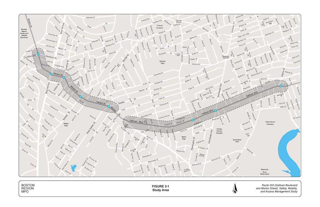
Route 203 (Gallivan Boulevard and Morton Street) is a state-owned principal arterial. It is a multilane roadway (two travel lanes in each direction) that runs in the east-west direction. Figure 3-1 shows the study area. The segment of Route 203 east of Fairmount Street is Gallivan Boulevard, and the segment to the west is Morton Street. The length of each of the two arterial segments (Gallivan Boulevard and Morton Street) in the study area is approximately one mile. Gallivan Boulevard crosses several north-south streets, including Granite Avenue, Dorchester Avenue, and Washington Street. Morton Street crosses West Selden Street, Norfolk Street, Blue Hill Avenue, and Harvard Street. The roadway serves commuter traffic and provides local access to businesses, institutions, and residences throughout the corridor. Both segments have different street designs and land uses.
 The Gallivan Boulevard segment has a residential setting. The roadway layout for the Gallivan Boulevard segment is typically 80 feet wide, with four 10-to-11-foot-wide travel lanes, two 6-to-8-foot-wide sidewalks on both sides of the roadway, and two 10-foot-wide buffers of grass and trees (one on each side of the street, between the sidewalk and the roadway curb).
There is no shoulder or median in this segment, and on-street parking is not allowed in most locations. The majority of the houses along Gallivan Boulevard have direct driveway access to Gallivan Boulevard.
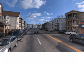 The Morton Street segment is a mix of commercial and residential settings. The roadway layout in this segment is typically 80 feet wide, with four 10-to-11-foot-wide travel lanes, 9-foot-wide on-street parking on both sides of the street, and 6-to-8-foot–wide sidewalks on both sides of Morton Street. The segment between Rhoades Street and Harvard Street has a 6-foot-wide median, with openings at selected locations. There is no shoulder in this segment. The majority of the businesses on Morton Street use on-street parking. Many of the multifamily homes on Morton Street have direct driveway access to Morton Street and also use on-street parking.
The following sections describe traffic, pedestrian, and bicycle volumes, conditions of sidewalks, crosswalks, and roadway pavement, crashes, traffic speeds, traffic delays and queues, signage, transit service and selected intersections in the study area
Figure 3-2 shows the average daily traffic (ADT) in the Gallivan Boulevard and Morton Street segments. The ADT ranged from 14,000 to 27,000 vehicles in the Gallivan Boulevard segment. In the Morton Street segment, the ADT ranged between 20,000 and 26,000 vehicles. Figure 3-2 also shows the turning-movement volumes at the intersections that were selected for study.
Table 3-1 shows the percentage of heavy vehicles at the study intersections during the peak periods when the turning movement counts were performed. On the average, the percentage of truck traffic in the peak period ranged between 2.0 and 4.0 percent.
Table 3-1
Percentage of Heavy Vehicles at Study Intersections during the AM and PM Peak Periods*
Intersection |
Percent of Heavy Vehicles |
Comment |
Gallivan Boulevard at Granite Avenue/Adams Street |
||
Gallivan Boulevard EB |
2.5 |
|
Gallivan Boulevard WB |
3.1 |
|
Granite Avenue NB |
2.5 |
|
Adams Street SB |
3.5 |
|
Gallivan Boulevard at Dorchester Avenue |
||
Gallivan Boulevard EB |
3.3 |
|
Gallivan Boulevard WB |
3.2 |
|
Dorchester Avenue NB |
6.4 |
High volume of MBTA bus traffic |
Dorchester Avenue SB |
8.9 |
High volume of MBTA bus traffic |
Gallivan Boulevard at Washington Street |
||
Gallivan Boulevard EB |
3.7 |
|
Gallivan Boulevard WB |
4.0 |
|
Washington Street NB |
3.9 |
|
Washington Street SB |
6.3 |
MBTA and school buses |
Morton Street at West Selden Street/Corbet Street |
||
Morton Street EB |
3.6 |
|
Morton Street WB |
3.9 |
|
West Selden Street NB |
3.2 |
|
Corbet Street SB |
1.2 |
|
Morton Street at Lucerne Street/Leston Street |
||
Morton Street EB |
3.0 |
|
Morton Street WB |
2.6 |
|
Lucerne Street NB |
5.8 |
Low-volume street |
Leston Street SB |
8.1 |
Low-volume street |
Morton Street at Blue Hill Avenue |
||
Morton Street EB |
3.2 |
|
Morton Street WB |
2.5 |
|
Blue Hill Avenue NB |
5.6 |
|
Blue Hill Avenue SB |
4.5 |
|
Morton Street at Havelock Street/Courtland Road |
||
Morton Street EB |
3.9 |
|
Morton Street WB |
3.4 |
|
Havelock Street |
3.3 |
|
Courtland Road |
3.0 |
|
*The AM peak period is 7:00 AM to 9:00 AM, and the PM peak period is 4:00 PM to 6:00 PM.
The observed truck traffic was composed of MBTA buses, school buses, and commercial trucks.
Table 3-2 shows the pedestrian crossings and bicycle counts at the study intersections. As Table 3-2 shows, there is moderate to high pedestrian activity at all of the study intersections. In addition, there is bicycle traffic in the Gallivan Boulevard and Morton Street arterial segments.
TABLE 3-2
Pedestrian Crossings and Bicycle Counts at the Study Intersections
|
|
Pedestrian Crossings |
|
Bicycle Counts |
||
Intersection |
|
AM Peak Period |
PM Peak Period |
|
AM Peak Period |
PM Peak Period |
Gallivan Blvd. and Granite Ave./Adams St. |
|
63 |
158 |
|
3 |
11 |
Gallivan Blvd. and Dorchester Ave. |
|
138 |
140 |
|
6 |
9 |
Gallivan Blvd. and Washington St. |
|
45 |
74 |
|
2 |
3 |
Morton St. and West Selden St./Corbet St. |
|
234 |
314 |
|
9 |
17 |
Morton St. and Lucerne St./Leston St. |
|
158 |
280 |
|
4 |
16 |
Morton Street and Blue Hill Ave. |
|
166 |
354 |
|
20 |
21 |
Morton St. and Courtland Rd./Havelock St. |
|
64 |
70 |
|
7 |
3 |
* The AM peak period is 7:00 AM to 9:00 AM, and the PM peak period is 4:00 PM to 6:00 PM
The sidewalks on Gallivan Boulevard and Morton Street are continuous and connect to residences, bus stops, side streets, businesses, and other land uses in the corridor. There is adequate separation between vehicular traffic and pedestrians on the sidewalks (10-foot buffers and 9-foot on-street parking on Gallivan Boulevard and Morton Street, respectively). The width of the sidewalks is adequate to safely accommodate pedestrians of all abilities.
The conditions of the sidewalks are generally in fair condition in the Gallivan Boulevard segment and in poor condition in th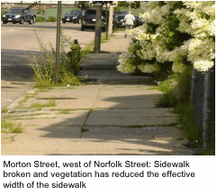 e Morton Street segment. In the Gallivan Boulevard segment, especially west of Dorchester Avenue, the sidewalks are crumbled and broken at several
locations and debris and vegetation have reduced the effective width of the sidewalk.
e Morton Street segment. In the Gallivan Boulevard segment, especially west of Dorchester Avenue, the sidewalks are crumbled and broken at several
locations and debris and vegetation have reduced the effective width of the sidewalk.
In the Morton Street segment, sidewalks have deteriorated extensively, especially in the stretch between Norfolk Street and Havelock Street, where sidewalks are broken and crumbled.
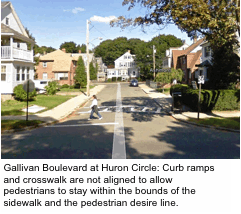
The main connectivity problems are that some curb ramps are not aligned with crosswalks to allow pedestrians to stay within the bounds of the sidewalk and follow pedestrian desire lines. Crosswalks, sidewalks, and curb ramps are not in alignment at the following locations in the Gallivan Boulevard segment: Huron Circle, Alicia Street, Oakridge Street, Alicia Street, and Pine Ridge Road.
In addition, most of the curb ramps in the Gallivan Boulevard and Morton Street segments lack detectable warning panels for pedestrians with disabilities. Throughout the two segments, detectable warning panels have been provided only for the intersections of Galli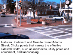 van Boulevard at Dorchester Avenue and at Adams Street.
In addition, there are choke points such as mailboxes, utility poles, landscaping, debris, weeds, and bushes that narrow the effective sidewalk width. On Gallivan Boulevard, there are no crosswalks at Rangeley Street and Druid Street. On Morton Street, there are no crosswalks at Verrill Street, Sutton Street, Wildwood Street, and Fairmount Street.
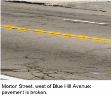 The pavement conditions for Gallivan Boulevard and Morton Street are shown Figure 3-3. The pavement condition is generally good in the Gallivan Boulevard segment, except for the stretch between Pleasant Hill Avenue and Morton Street, where the pavement condition is poor. In the Morton Street segment, the pavement condition is generally poor. In addition, recent field observations indicate that there are extensive pavement cracking and rutting in the Morton Street segment due to drainage problems and lack of maintenance over the years.
There are three intersections in the Gallivan Boulevard and Morton Street segments that are on MassDOT’s 2009 list of the top 200 high-crash intersections:
Many of the study intersections have crash rates higher than the Highway Division District 6 average crash rate for intersections. Table 3-3 presents the crash rate at the intersections selected for study. The crash rate work sheets for the study intersections are in Appendix C. An analysis of the MassDOT crash database for the period 2007 to 2009 indicated three pedestrian and bicyclist crashes in the Gallivan Boulevard segment. In the Morton Street segment, there were 11 pedestrian and 3 bicyclist crashes in the same period, all of which involved injuries.
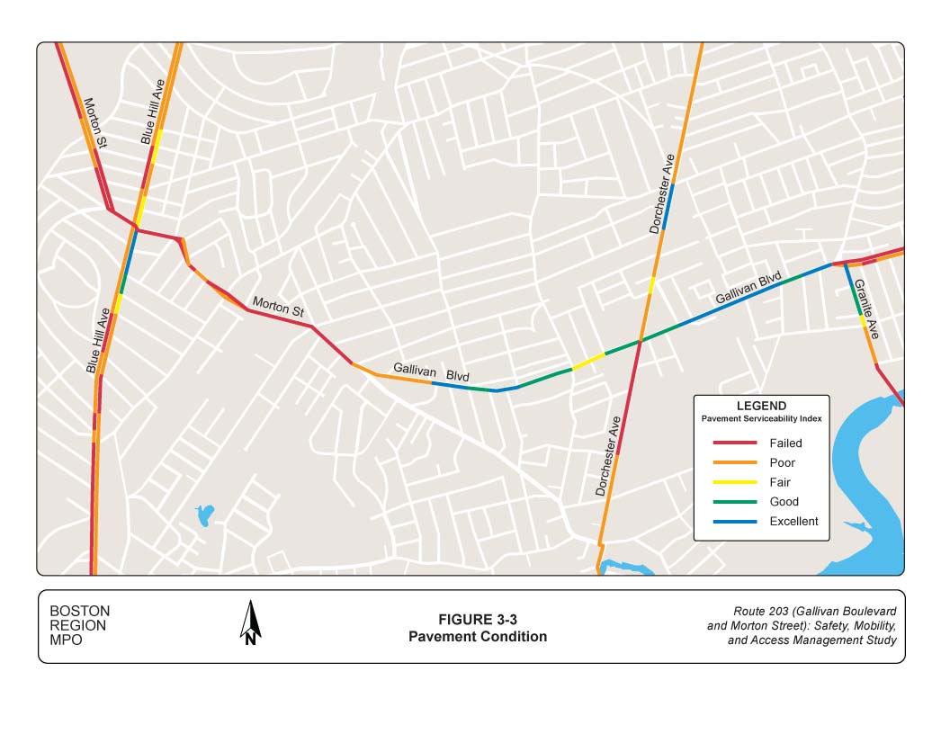
TABLE 3-3
Crash Rates for Selected Intersections
Intersection |
Total Number of Crashes |
Number of Years |
Total Daily Approach Traffic |
Crash Rate |
Gallivan Blvd. and Granite Ave./Adams St. |
56 |
4 |
28,833 |
1.33 |
Gallivan Blvd. and Dorchester Ave. |
66 |
4 |
24,222 |
1.87 |
Gallivan Blvd. and Washington St. |
26 |
4 |
22,944 |
0.78 |
Morton St. and West Selden St./Corbet St. |
29 |
4 |
26,000 |
0.76 |
Morton St. and Lucerne St./Leston St. |
36 |
4 |
22,056 |
1.12 |
Morton Street and Blue Hill Ave. |
33 |
3.5 |
43,778 |
0.59 |
Morton St. and Courtland Rd./Havelock St. |
20 |
3 |
25,300 |
0.72 |
Note: Shading denotes intersections with crash rates higher than the MassDOT Highway Division District 6 average crash rate.
The posted speed limit in the Gallivan Boulevard and Morton Street segments is 30 mph. Figures 3-4 and 3-5 show the average peak-period travel speeds in the Gallivan Boulevard and Morton Street segments. The AM peak-period travel speeds were collected between 6:30 AM and 9:30 AM; the PM peak-period travel speeds were collected between 3:30 PM and 6:30 PM. The data were collected as part of the Boston Region MPO Congestion Management Process (CMP) between 2003 and 2005. Most of the traffic delays were concentrated at the signalized intersections.
A MassDOT spot speed survey, a two-day midweek (Tuesday through Thursday) survey, conducted on Gallivan Boulevard near Rockne Avenue in June 2012. The spot speed survey indicated the following conditions for the westbound and eastbound traffic:
The spot speed survey generally indicated that motorists were speeding in the Gallivan Boulevard segment, especially during off-peak periods. The CMP travel speeds indicate that there was congestion (delay at intersections) during peak periods. A spot speed survey was not conducted for the Morton Street segment because MassDOT could not find a suitable location for speed detectors on the four-lane undivided roadway.
Traveling through the Gallivan Boulevard and Morton Street segments, motorists mostly encounter traffic delays at the signalized intersections. The critical intersections where motorists experience long delays are Morton Street at Blue Hill Avenue and Gallivan Boulevard at Granite Avenue/Adams Street. The traffic delays and subsequent queues are due to insufficient capacity at these two intersections.to handle the traffic demands of users.
Figure 3-6 shows the transit services in the study area and the locations of the bus stops. The MBTA Fairmont commuter rail line has a station at Morton Street near the Evans Street intersection. The MBTA Red Line’s Cedar Grove Station is accessible from Morton Street via Rangeley Street. In addition, Brockton Area Transit (BAT) operates bus service between the Brockton and the Ashmont MBTA stations. There are many transit services and users in the Gallivan Boulevard and Morton Street segments; therefore, it is important to improve the roadway so that it would be safe for people to walk to and from bus stops and train stations and buses could run on time.
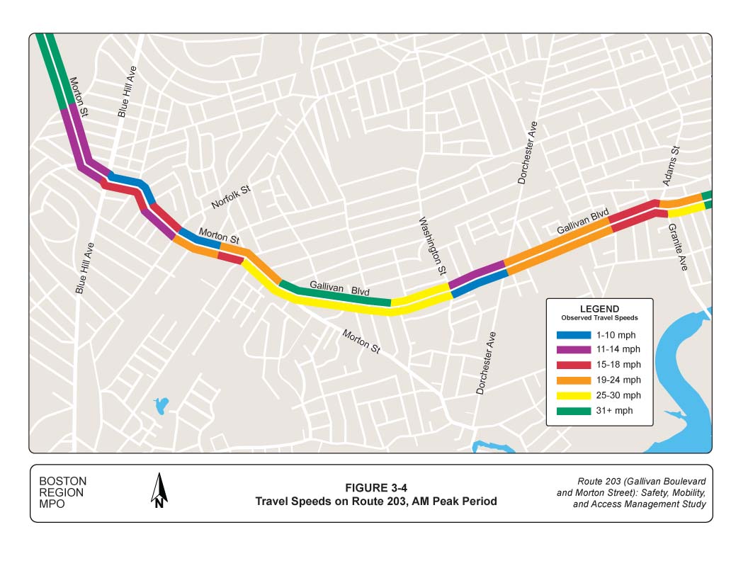
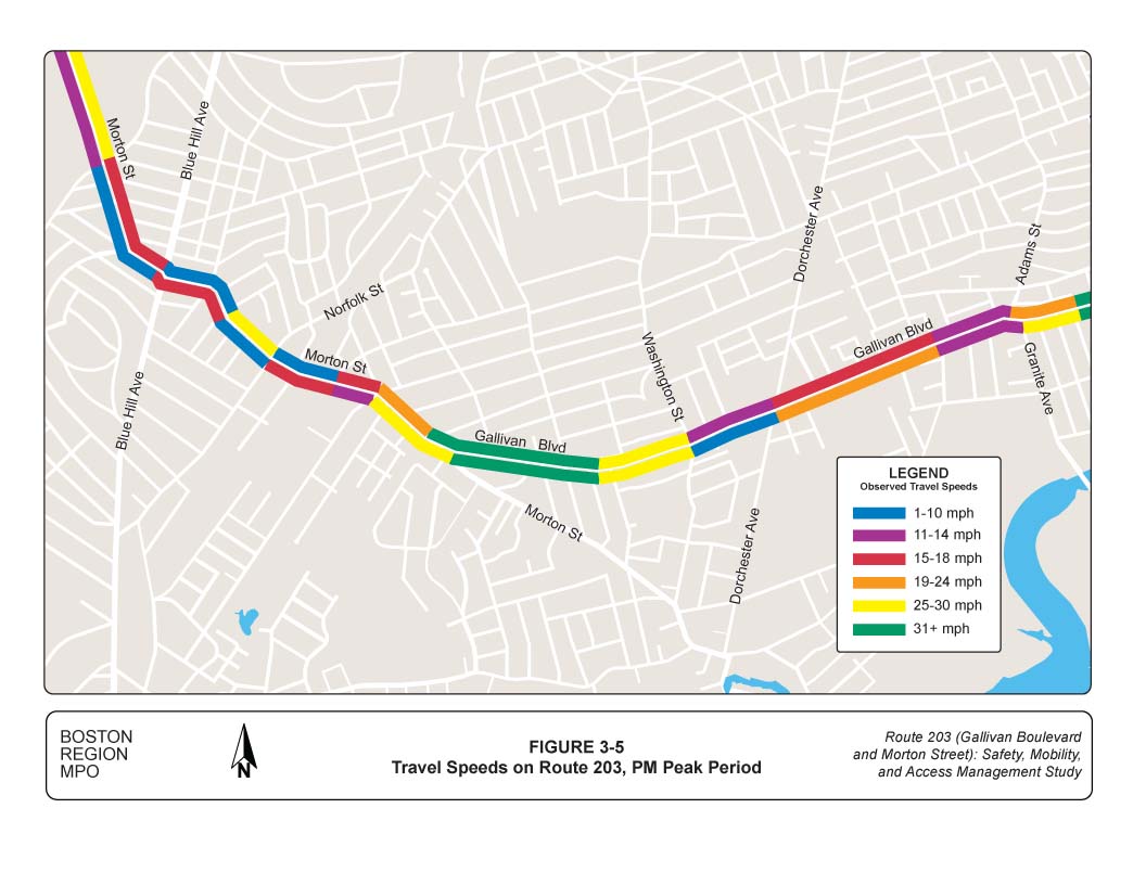
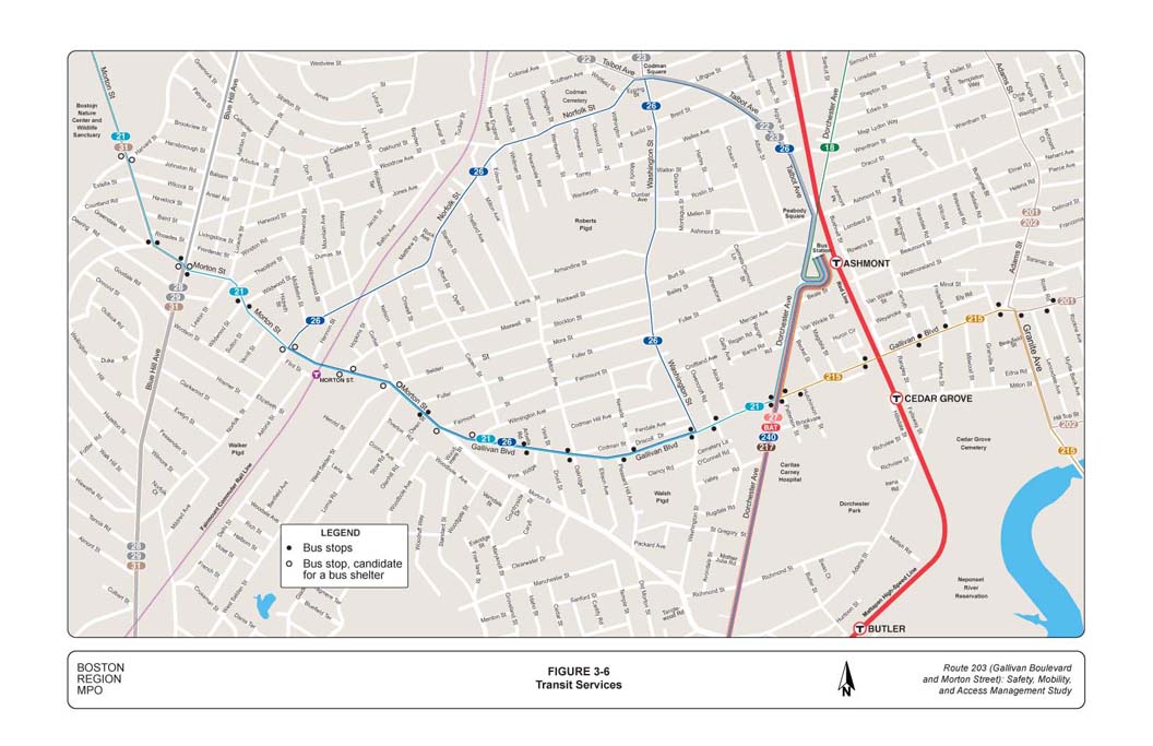
Table 3-4 presents bus transit performance in the study area in terms of the MBTA’s Service Delivery Policy standards for the bus routes in the study area. The purpose of the Service Delivery Policyis to ensure that the MBTA provides quality transit services that meet the needs of the riding public and are consistent with the MBTA’s mission. The policy establishes service objectives that define the key performance characteristics of quality transit services and identifies quantifiable service standards that are used to measure whether or not the MBTA’s transit services achieve the service objectives and to evaluate whether MBTA services are provided in an equitable manner (as defined by Title VI of the Civil Rights Act).
TABLE 3-4
Bus Service Evaluation in the Study Area
|
Service Delivery Policy Standard |
|||
|
Span |
Frequency |
Loading |
Schedule Adherence (%) |
Bus Routes on Gallivan Boulevard and Morton Street |
|
|
|
|
Route 21: Ashmont Station – Forest Hill Station |
|
|
x |
70.0 |
Route 26: Ashmont Station – Norfolk and Morton Belt Line |
|
|
|
61.9 |
Route 31: Mattapan Station – Forest Hill Station |
|
|
x |
77.0 |
Route 201 Fields Corner Station – Fields Corner Station |
|
x |
|
60.2 |
Route 215: Quincy Center – Ashmont Station |
|
x |
|
54.0 |
|
|
|
|
|
Bus Routes Crossing Gallivan Boulevard and Morton Street |
|
|
|
|
Route 24 |
|
|
|
69.0 |
Route 27 Mattapan Station – Ashmont |
|
x |
|
83.0 |
Route 28 Mattapan Station – Ruggles |
|
|
x |
|
Route 29 Mattapan Station – Jackson Square Station |
|
|
x |
55.0 |
Route 202 Fields Corner Station – Fields Corner Station |
|
x |
|
60.2 |
Route 217 Wollaston Station – Ashmont |
x |
x |
|
56.0 |
Route 240 Avon Line – Ashmont Station |
|
|
x |
63.0 |
x denotes failed the Service Delivery Policy standard.
Source: MBTA
The Service Delivery Policy standards are summarized in Table 2-3. Readers are encouraged to reference the MBTA Service Delivery Policy for more information on the standards for minimum coverage, span of service, and frequency of service, as well as the standards for schedule adherence and vehicle load.4 According to Table 3-4, some of the service delivery standards are not met, and there is room for improvement in schedule adherence, loading, and frequency on some of routes.
The MBTA has already taken action to address some of the service problems presented in Table 3-4. The MBTA has added a few round-trip services on bus Route 21 to address the crowding problems and improve headways. In addition, the MBTA added trips on Route 31 as part of the interim mitigation measures for the Fairmount Line Improvement project. In addition, since 2010, the MBTA has increased the weekday capacity on Route 28 by 24% using articulated buses. On Route 29, the MBTA has added one round-trip to correct the crowding problem.
In addition, MPO staff observed that throughout the Gallivan Boulevard and Morton Street segments, there are no benches or bus shelters for transit users. The MBTA’s policy for shelter installation suggests there should be at least 70 boardings a day at a stop for the stop to be a candidate for a shelter. Table 3-5 shows the total daily boardings at bus stops on Route 203 in the study area. Portions of six MBTA bus routes serve Route 203 in the segment from Gallivan Boulevard at Granite Avenue/Adams Street to Morton Street at Harvard Street. A review of CTPS bus stop data collected in 2007 through 2009 shows that 10 bus stops in this segment have daily boardings of 70 passengers or greater. Those 10 stops are indicated with shading in Table 3-5. These candidate stops must also meet the suitability test described in Chapter 2, section 2.2.3.
On-street parking is generally not allowed on Gallivan Boulevard. The roadway layout for the Gallivan Boulevard segment is typically 80 feet wide, with four 10-to-11-foot-wide travel lanes, a 6-to-8-foot-wide sidewalk on both sides of the roadway, and a 10-foot-wide buffers of grass and trees (between each sidewalk and the roadway curb) on both sides. There is no shoulder or median in this segment.
TABLE 3-5
Total Daily Boardings at Bus Stops on Route 203 in the Study Area
Route (s) |
Stop ID Number |
Stop Name |
Total Boardings |
21, 31 |
543 |
Morton Street at Blue Hill Ave |
596 |
21, 26 |
540 |
Morton Street at Selden Street |
246 |
21, 31 |
9406 |
Morton Street at Harvard Street |
233 |
21 |
541 |
Morton Street at Norfolk Street |
226 |
21 |
526 |
Morton Street at Blue Hill Ave |
142 |
21, 26 |
530 |
Morton Street at W Selden Street |
140 |
21 |
528 |
Morton Street at Norfolk Street |
123 |
21, 26 |
10540 |
Morton Street at Evans Street |
95 |
21, 26 |
499 |
Gallivan Boulevard at Wilmington Avenue |
90 |
21, 26 |
507 |
Gallivan Boulevard at Morton Street |
78 |
21 |
542 |
Morton Street at Wildwood Street |
46 |
21 |
497 |
Gallivan Boulevard at Milton Avenue |
43 |
21, 26 |
539 |
980 Morton Street at opposite Owen Street |
41 |
21, 26 |
494 |
Gallivan Boulevard at Washington Street |
40 |
21, 26 |
529 |
Morton Street at opposite Evans Street |
38 |
21, 26 |
508 |
Gallivan Boulevard at opposite Arbella Road |
37 |
21, 31 |
525 |
Morton Street at Greendale Road |
37 |
21, 26 |
531 |
Morton Street at Owen Street |
33 |
21 |
527 |
Morton Street at Wildwood Street |
32 |
21, 31 |
524 |
Morton Street at Harvard Street |
30 |
21, 26 |
509 |
Gallivan Boulevard at Oakridge Street |
29 |
21, 26 |
501 |
Gallivan Boulevard at Nevada Street |
27 |
21, 26 |
498 |
Gallivan Boulevard at Arbella Road |
25 |
21 |
496 |
Gallivan Boulevard at Owencroft Road |
22 |
26 |
37111 |
Washington Street at opposite Lithgow Street |
17 |
21, 26 |
510 |
Gallivan Boulevard at Pleasant Hill Avenue |
16 |
201 |
3078 |
Gallivan Boulevard at Ross Road |
13 |
215 |
3370 |
Gallivan Boulevard at Kenmare Road |
8 |
215 |
3375 |
Gallivan Boulevard at Hutchinson Street |
7 |
215 |
33691 |
Granite Avenue at Gallivan Boulevard |
5 |
21 |
532 |
Gallivan Boulevard at Stone Terrace |
3 |
215 |
3372 |
Gallivan Boulevard at Carruth Street |
1 |
215 |
3376 |
Gallivan Boulevard at opposite Huron Circle |
0 |
215 |
33761 |
Gallivan Boulevard at opposite Carruth Street |
0 |
215 |
3377 |
Gallivan Boulevard at Adams Street |
0 |
215 |
3371 |
Gallivan Boulevard at Frederika Street |
0 |
215 |
3373 |
Gallivan Boulevard at Huron Circle |
0 |
On-street parking is generally allowed in the Morton Street segment and it is free; there are no parking meters installed in the segment. The roadway layout in this segment is typically 80 feet wide, with four 10-to-11-foot travel lanes, and 9-foot on-street parking and 6-to-8-foot sidewalks on both sides of Morton Street. Street cleaning and snow emergency signs are installed throughout the segment; the street cleaning signs prohibit on-street parking on Wednesdays at specific times from April 1 to November 30. Parking is prohibited at or near the major signalized intersections and signs have been installed for this purpose. On-street parking in the Morton Street segment serves both commercial and residential activities. MPO staff did not conduct a parking survey for the Morton Street segment.
The pavement condition in the Gallivan Boulevard segment between Pleasant Hill Avenue and Morton Street is poor.
The following one-way streets do not have one-way signs: Becket Street, Hutchinson Street, Oakridge Street, and Pleasant Hill Avenue.
Spot speed studies indicate that there is speeding in the Gallivan Boulevard segment during the off-peak hours. The average speed was 3 to 4 mph higher than the posted speed limit of 30 mph. The 85th percentile speed was approximately 37 mph. About 66 percent of motorists were traveling between 30 and 40 mph. All of the important spot speed statistics were higher than the posted speed limit.
Routes 21 and 26 run along Gallivan Boulevard and meet most of the MBTA’s Service Delivery Policy standards. The following bus transit problems were identified in the Gallivan Boulevard segment.
The critical intersection in the Gallivan Boulevard segment, where traffic demand exceeds capacity, is the Granite Avenue/Adams Street intersection. Motorists experience long delays and queuing at this intersection. The intersection and all of its approaches operate at LOS F during the PM peak period, when there are queues and long delays at the approaches. In addition, during the AM peak period, the Gallivan Boulevard eastbound approach and Granite Avenue operate at LOS F.
The pavement condition in the Morton Street segment is poor. There are longitudinal and lateral cracks and rutting in the pavement due to lack of maintenance and to drainage problems in this segment.
There are neighborhood complaints of speeding during the off-peak hours in the Morton Street segment. Due to field conditions, the Highway Division was unable to collect spot speed data in the Morton Street segment. It was impossible for the Highway Division to find a location in the segment where the roadway is divided and queues do not have an effect on motorists’ travel speeds. However, MPO staff expect Morton Street speed conditions to be similar to those observed in the Gallivan Boulevard segment.
The critical intersection in the segment where traffic demands exceed capacity is at Morton Street and Blue Hill Avenue. Motorists experience long delays and queuing at the intersection. The operations at this intersection fail (LOS E or F) during the AM and PM peak periods, when long queues occur on all approaches of the intersection. Other intersections on Morton Street that experience delays and queues are Morton Street at Norfolk Street and Morton Street at West Selden Street/Corbet Street.
Three intersections in the Gallivan Boulevard segment and four intersections in the Morton Street segments were selected for study. The selection was based primarily on safety (crashes at intersections).
The following section describes these seven intersections, including existing conditions and identified problems.
The intersection of Gallivan Boulevard, Granite Avenue, and Adams Street is a signalized intersection under the jurisdiction of MassDOT. Granite Avenue and Adams Street are city-owned principal and urban minor arterials, respectively. The land use in the vicinity of the intersection is primarily commercial. In the vicinity of the intersection, Gallivan Boulevard is a two-way, four-lane roadway (two lanes in each direction); no left-turn lane is provided on Gallivan Boulevard. Granite Avenue is a two-way, three-lane roadway, with two northbound lanes 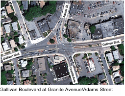 and one southbound lane; one of the two northbound lanes becomes an exclusive left-turn lane approximately 150 feet from the intersection. Adams Street is a two-way, two-lane roadway with an exclusive left-turn lane and an exclusive right-turn lane at the approach to the intersection.
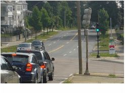
The intersection experiences high pedestrian activity due to the presence of businesses in the vicinity. There were 221 pedestrian crossings during the two two-hour AM and PM peak periods, when MPO staff conducted turning-movement counts. All of the intersecting streets have 8-foot-wide sidewalks on both sides of each street, and marked crosswalks at each approach, with median cutouts on the approach. Each street corner has curb ramps without detectable warning panels for pedestrians. However, some of the curb ramps are not even with the road surface. In addition, there is no opening in the median on the west leg of Gallivan Boulevard for the crosswalk (see photo above). There are no bike lanes on any of the intersecting 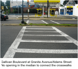 streets; bicyclists share the lanes with vehicular traffic. In addition, there are no signs or pavement markings at the intersection or in its vicinity to assist bicyclists or inform motorists to share the road. In addition, there is no detection equipment for bicycles at the intersection.
The MBTA has installed bus stop signs at the stops in the vicinity of the intersection. Routes 201, 202, and 215 have stops at the intersection, but there are no benches or shelters at the bus stops and they do not meet the MBTA’s policy for shelter installation. The intersection’s corner radii are wide enough to accommodate buses, emergency vehicles, and trucks at the intersection. As presented in Table 3‑4, Routes 201, 202, and 215 fail the MBTA’s Service Delivery Policy’s frequency standard.
The traffic signals at the intersection are post-mounted in the sidewalks and in the medians on Gallivan Boulevard and Adams Street, and they do not provide good conspicuity. In addition, motorists' line-of-sight to signal heads is blocked by trucks in the traffic stream. The existing signal timing and phase pattern for the intersection are in Appendix B. Gallivan Boulevard eastbound traffic has a leading protected phase during which its left-turning traffic is protected; after the protected phase, the left turns are permitted-only. The westbound Gallivan Boulevard traffic is not provided with a lagging protected phase, so its left-turning traffic is always permitted-only. Granite Avenue and Adams Street left-turning traffic is provided with a protected left-turn phase; after the protected phase, the left turns are permitted-only.
Pedestrians at the intersection have a pedestrian-activated exclusive pedestrian phase. There are no countdown pedestrian timers and no accessible signals to assist pedestrians in crossing at the intersection. The signal controller is functioning well, but during the data collection in the field it was observed that the loop detectors on Gallivan Boulevard were not working well. This malfunction causes the traffic signal to act as a pretimed signal. MPO staff did not observe any bicycle detection equipment at the intersection.
This intersection ranks number 128 on MassDOT’s 2009 statewide list of top 200 high-crash intersections, with an equivalent property damage only (EPDO) rating of 115. The ranking is based on crashes in MassDOT’s Registry of Motor Vehicles (RMV) crash database for 2007 to 2009. 5
In addition, MPO staff analyzed crash data from the RMV that were recorded at the intersection between January 2006 and December 2009 (a four-year period). Of the 56 crashes, 26 were mapped on a collision diagram, (in Appendix C).6 Only crashes with crash diagrams produced by police were mapped on that collision diagram. According to the collision diagram, the majority of the angle and rear-end crashes involved Gallivan Boulevard’s westbound traffic. Fifty percent of the mapped crashes were angle type involving left-turning motorists. Nine of the mapped crashes resulted in nonfatal injuries, and there were no fatal injuries.
In addition, using the PM peak-hour traffic volumes at the intersection, the crash rate was calculated as 1.33 crashes per million entering vehicles (MEV), which exceeds the Highway Division District 6 average crash rate of 0.77 MEV for signalized intersections.7 Worksheets of the crash rates are in Appendix C. The details of the 56 crashes in terms of severity, manner of collision, and ambient light conditions are:
MPO staff performed intersection capacity analyses by using data collected in the field. Synchro 8 traffic operation analysis software was used.8 Table 3-6 gives the results of the capacity analysis. The Synchro outputs of the capacity analysis are in Appendix E.
TABLE 3-6
Existing AM and PM Peak-Hour Level of Service
Approach |
Movement |
AM Existing |
|
PM Existing |
||||
LOS |
Delay1 |
Queue2 |
|
LOS |
Delay |
Queue |
||
Gallivan Blvd. EB |
L+T+R |
F |
185 |
#908 |
|
F |
267 |
#824 |
Gallivan Blvd. WB |
L+T+R |
D |
41 |
#272 |
|
F |
198 |
#497 |
Granite Ave. NB |
L |
D |
46 |
#411 |
|
F |
103 |
#450 |
Granite Ave. NB |
T+R |
E |
70 |
#576 |
|
F |
121 |
#533 |
Adams St. SB |
L |
C |
27 |
75 |
|
D |
47 |
126 |
Adams St. SB |
T |
D |
44 |
263 |
|
E |
66 |
#353 |
Adams St. SB |
R |
C |
25 |
91 |
|
D |
40 |
81 |
|
|
|
|
|
|
|
|
|
Gallivan Blvd. EB |
L+T+R |
E |
58 |
#338 |
|
D |
45 |
#302 |
Gallivan Blvd. WB |
L+T+R |
C |
32 |
#262 |
|
C |
32 |
#235 |
Dorchester Ave. NB |
L+T+R |
C |
32 |
#329 |
|
D |
42 |
#332 |
Dorchester Ave. SB |
L+T+R |
C |
24 |
#260 |
|
F |
132 |
#438 |
|
|
|
|
|
|
|
|
|
Gallivan Blvd. EB |
L+T+R |
C |
22 |
246 |
|
C |
21 |
273 |
Gallivan Blvd. WB |
L+T+R |
B |
19 |
214 |
|
C |
23 |
#304 |
Washington St. NB |
L+T+R |
C |
29 |
#471 |
|
C |
23 |
217 |
Washington St. SB |
L+T+R |
B |
18 |
159 |
|
C |
31 |
#316 |
|
|
|
|
|
|
|
|
|
Morton St. EB |
L+T+R |
C |
30 |
321 |
|
C |
33 |
#504 |
Morton St. WB |
L+T+R |
D |
39 |
#443 |
|
D |
37 |
#442 |
West Selden St. NB |
L+T+R |
D |
47 |
135 |
|
D |
38 |
#168 |
Selden St. SB |
L+T+R |
D |
42 |
73 |
|
D |
38 |
84 |
|
|
|
|
|
|
|
|
|
Morton St. EB |
T |
A |
0 |
0 |
|
A |
0 |
0 |
Morton St. WB |
T |
A |
0 |
0 |
|
A |
0 |
0 |
Leston St. NB |
L+T+R |
B |
10 |
20 |
|
B |
12 |
20 |
Lucerne St. SB |
L+T+R |
B |
13 |
20 |
|
C |
17 |
20 |
|
|
|
|
|
|
|
|
|
Morton St. EB |
T+R |
E |
73 |
#573 |
|
F |
185 |
#877 |
Morton St. WB |
T+R |
F |
116 |
#722 |
|
F |
170 |
#613 |
Blue Hill Ave. NB |
L |
F |
232 |
#567 |
|
F |
105 |
#387 |
Blue Hill Ave. NB |
T+R |
E |
69 |
#446 |
|
E |
57 |
393 |
Blue Hill Ave. SB |
L |
E |
74 |
156 |
|
F |
92 |
#353 |
Blue Hill Ave. SB |
T+R |
E |
47 |
251 |
|
F |
87 |
#580 |
|
|
|
|
|
|
|
|
|
Morton St. EB |
L+T+R |
A |
1 |
20 |
|
A |
3 |
25 |
Morton St. WB |
L+T+R |
A |
3 |
25 |
|
A |
3 |
20 |
Courtland Rd. |
NA |
NA |
NA |
NA |
|
NA |
NA |
NA |
Havelock St. |
NA |
NA |
NA |
NA |
|
NA |
NA |
NA |
1 Delay in seconds per vehicle.
2 95th percentile queue length in feet
# means that the 95th percentile volume exceeds capacity.
Note: Shading denotes street approaches with delay and queuing problems.
The analysis indicates that the intersection operates at LOS F during the AM and PM peak hours, when traffic demand exceeds the capacity of the intersection In the AM peak hour, the eastbound Gallivan Boulevard traffic and northbound Granite Avenue traffic operate at LOS F and LOS E, respectively. In the PM peak hour, traffic on all of the approaches operates at LOS E or worse. The longest traffic queues occur at the eastbound Gallivan Boulevard and northbound Granite Avenue approaches.
The following problems were identified at the intersection through field data collection, data analysis, and discussions with representatives from MassDOT and City of Boston.
 capacity of the intersection.
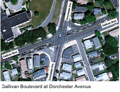 The intersection of Gallivan Boulevard and Dorchester Avenue is a signalized intersection under the jurisdiction of MassDOT. It has a signal-controlled channelized right turn on each approach of Gallivan Boulevard. Dorchester Avenue is a two-way, two-lane, city-owned urban principal arterial. The land use in the vicinity of the intersection is mixed (residential, retail, and institutional). Carney Hospital is located about 500 feet south of the intersection on Dorchester Avenue. The Boston Home, a not-for-profit specialized care residence for adults with neurological diseases is located in the northwest corner of the intersection.
The intersection experiences high pedestrian activity due to the businesses located in the vicinity. There were 278 crossings during the two two-hour AM and PM peak periods, when MPO staff conducted turning-movement counts. All of the intersecting streets had 6-to-8-foot-wide sidewalks on both sides of each street and a 10-foot-wide marked crosswalk on each leg of the intersection. Each street corner had curb ramps with detectable warning panels for pedestrians. Pedestrian signals with pedestrian-activated push buttons are provided for crossing Gallivan Boulevard and Dorchester Avenue. There is a shared lane on Dorchester Avenue with sharrow markings, but not on Gallivan Boulevard. Although Dorchester Avenue is marked as shared lanes, MPO staff did not observe any bicycle detection equipment at the intersection.
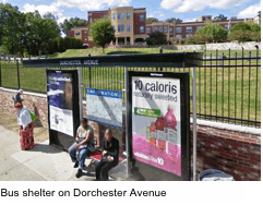 The MBTA bus Routes 21, 27, 215, 217, and 240 had stops at the intersection, as well as BAT’s Route 12. There is a bus shelter with a bench at the bus stop on Dorchester Avenue just north of the intersection. In addition, the MBTA has installed bus stop signs at the stops. Corner radii at the intersection are wide enough to accommodate buses, trucks, and emergency vehicles. As presented in Table 3‑4, Routes 21, 27, 215, 217, and 240 fail one or more of the MBTA’s Service Delivery Policy standards.
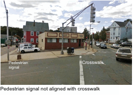 The traffic signals at the intersection are overhead-signal displays; they provide good conspicuity and motorists’ line of sight to the signal heads is not blocked by trucks in the traffic stream. The signal timing and phase plan for the intersection are in Appendix B. Gallivan Boulevard westbound traffic has a leading protected phase and the eastbound traffic has a lagging protected phase. The same leading-lagging protected/permitted left-turn phasing is also provided on Dorchester Avenue. Pedestrians at the intersection have a pedestrian-activated exclusive phase.
During a field visit, it was observed that the pedestrian walk phase is too short (five seconds). In addition, MPO staff observed that the pedestrian signal in the southeast corner of the intersection for crossing Gallivan Boulevard in the southbound direction is not aligned with the crosswalk; pedestrians have to search for it. In addition, there are neither countdown pedestrian timers nor accessible signals to assist pedestrians in crossing. In addition, there is no bicycle detection at the intersection.
The intersection ranks number 55 on MassDOT’s 2009 statewide list of top 200 high-crash intersections, with an equivalent property damage only (EPDO) rating of 149. The ranking is based on crashes in MassDOT’s RMV crash database for 2007 to 2009. There were 49 crashes in that period (25 resulted in injuries and 24 in property damage only).
In addition, MPO staff analyzed crash data from MassDOT’s RMV database that were recorded at the intersection between January 2006 and December 2009. Of the 66 crashes, 33 were mapped on a collision diagram (in Appendix C). Only crashes with crash diagrams were mapped on the collision diagram. According to the collision diagram, the majority of the angle and rear-end crashes involve Gallivan Boulevard’s westbound traffic. Nineteen of the mapped crashes resulted in nonfatal injuries and there were no fatal injuries.
Using the PM peak-hour traffic volumes at the intersection, the crash rate was calculated as 1.87 crashes per million entering vehicles (MEV), which exceeds the Highway Division District 6 average crash rate of 0.77 MEV for signalized intersections. Worksheets of the crash rates are in Appendix C.
The details the 66 crashes in terms of severity, manner of collision, and ambient light conditions are:
Table 3-6 presents the results of the intersection capacity analysis. Synchro 8 outputs of the capacity analysis (in Appendix E). The intersection capacity analysis indicates that the intersection operates at LOS C during the AM and PM peak hours.
The following problems were identified at the intersection through field visits and data analysis and discussions with representatives from MassDOT and City of Boston:
There is no loop or video detection for bicycles at the intersection.
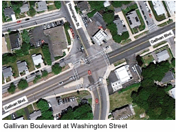 The intersection of Gallivan Boulevard and Washington Street is signalized; it is under the jurisdiction of MassDOT. Washington Street is a city-owned urban minor arterial. The land use in the vicinity of the intersection is primarily commercial (retail, gas station, automobile repair shop). At the intersection, Gallivan Boulevard is a two-way, four-lane roadway (two lanes in each direction) with no left-turn lane. Washington Street is a two-way, two-lane roadway. Driscoll Drive, a one-way street, intersects the north leg of Washington Street just north of the intersection of Washington Street and Gallivan Boulevard. A triangular island on Gallivan Boulevard eastbound approach separates the channelized right-turn lane from the eastbound through lanes.
The intersection experiences moderate pedestrian activity. There were a total of 119 pedestrian crossings during the two two-hour AM and PM peak periods, when MPO staff conducted turning-movement counts. All of the intersecting streets have 6-to-8-foot-wide sidewalks on both sides of each street. There is a 10-foot-wide marked crosswalk on each leg of the intersection. Each street corner has curb ramps, but there are no detectable warning panels at the ends of the ramps.
MBTA bus Routes 21 and 26 have stops in the vicinity of the intersection. Bus stop signs are provided, but there is no bench or bus shelter at the bus stops. Presently, the bus stops do not meet the MBTA’s standards for shelter installation. The intersection’s corner radii are wide enough to accommodate buses, emergency vehicles, and trucks. As presented in Table 3-4, Route 21 fails the loading standard of the MBTA’s Service Delivery Policy.
The traffic signal at the intersection is a mix of post-mounted and overhead signal heads. The post-mounted signal heads do not provide good conspicuity and are not in the motorists' line of sight. The signal controller is an Eagle-type controller, and the loop detectors were functioning well on Gallivan Boulevard during the field visit. The existing signal timings and phase sequence are included in Appendix B. All of the left turns at the intersection are permitted-only. Pedestrians at the intersection have a pedestrian-activated exclusive pedestrian phase. There are no countdown pedestrian timers and no audible cues to assist pedestrians at the intersection. Field observations indicated that the pedestrian clearance time is not adequate, and the pedestrian signal in the southeast corner for crossing Washington Street in the eastbound direction is out of alignment. The existing signal timing indicates 11 seconds of pedestrian clearance time for the intersection, which is not enough for crossing Washington Street at the north leg of the intersection.
The intersection is not on MassDOT’s 2009 statewide list of the top 200 high-crash intersections. It has an equivalent property damage only (EPDO) rating of 48 based on information from the MassDOT crash database for the period 2007–09.
MPO staff analyzed Registry of Motor Vehicles (RMV) crash data that were recorded at the intersection between January 2006 and December 2009. Of the 26 crashes, 13 were mapped on a collision diagram (in Appendix C). Only crashes that had crash diagrams provided by the police were mapped on the collision diagram. The majority of the mapped crashes were angle crashes involving left-turning motorists; the majority of the crashes resulted in property damage only. Two of the mapped crashes involved vehicles exiting the gas station in the southeast corner of the intersection.
Using the PM peak-hour traffic volumes at the intersection, the crash rate was calculated as 0.78 crashes per million entering vehicles (MEV), which barely exceeds the Highway Division District 6 average crash rate of 0.77 MEV for signalized intersections. Worksheets of the crash rates are in Appendix C. The details of the 26 crashes in terms of severity, manner of collision, and ambient light are:
There were no pedestrian or bicycle crashes at the intersection.
Table 3-6 presents the results of the intersection capacity analysis. The Synchro 8 outputs of the intersection capacity analysis are in Appendix E. The analysis indicates that the intersection operates at LOS C or better during the AM and PM peak hours.
The following problems were identified at the intersection through field visits and data analysis and discussions with representatives from MassDOT and City of Boston:
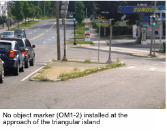
There is no loop or video detection for bicycles at the intersection.
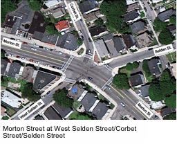 The intersection of Morton Street, West Selden Street, Selden Street, and Corbet Street is a signalized intersection under the jurisdiction of MassDOT. West Selden is a two-way, two-lane, city-owned urban collector. Corbet Street and Selden Street are one-way, one-lane, urban collector streets; Corbet Street’s traffic heads into the intersection, while Selden Street’s traffic heads away from the intersection. The intersection is situated on the crest of a horizontal curve on Morton Street. The land use in the vicinity of the intersection is mixed (residential and retail).
The intersection experiences high pedestrian activity due to the businesses in the vicinity. There were 575 pedestrian crossings during the two two-hour AM and PM peak periods, when MPO staff conducted turning-movement counts. All of the intersecting streets had 6-to-8-foot-wide sidewalks on both sides of each street. There is a 10-foot-wide marked crosswalk on each leg of the intersection. Each street corner has curb ramps for pedestrians, but there are no detectable warning panels. There are no bike lanes on any of the intersecting streets; bicyclists share the lanes with motorists.
The MPO staff’s Safe Access to Transit for Pedestrian and Bicyclists study recommended installing a bicycle lane on Morton Street from Evans Street to Norfolk Street.9 In addition, MPO staff suggested that uniform pedestrian signal equipment and devices be used in upgrading traffic signal equipment in the Morton Street and Gallivan Boulevard segments to make it easier for motorists and pedestrians.
MBTA bus Routes 21 and 26 have stops at the intersection; the stop at Selden Street has 246 total daily boardings and the stop at West Selden Street has 140 total boardings. The MBTA has installed bus stop signs at the intersection. There are no bus shelters or benches at any of the stops in the vicinity of the intersection even though the total daily boardings meet the MBTA criteria for bus shelter installation.
The traffic signal equipment at the intersection is a mix of post-mounted and overhead signal displays. Both approaches of Morton Street have overhead signal displays, which provide good conspicuity, and motorists’ line of sight to the signal heads is not blocked. The signal controller is a new Eagle-type controller and is functioning well; the loop detectors are also functioning well at the intersection. W3-3 (Signal Ahead) signs are posted in the westbound direction of Morton Street as it approaches the intersection to warn motorists of the presence of a traffic signal ahead. The signal displays on West Selden Street and Corbet Street are post-mounted in the sidewalk. The signal timing and phase plan for the intersection are in Appendix C. All left-turn movements at the intersection are permitted-only. Pedestrians at the intersection have a pedestrian-activated exclusive pedestrian phase. The pedestrian signal is assigned a 6-second walk interval and a pedestrian clearance interval of 14 seconds. Both the pedestrian walk and clearance intervals are inadequate for crossing Gallivan Boulevard. There are no countdown pedestrian timers and the accessible pedestrian signals to assist pedestrians in crossing at the intersection are not working. In addition, it appears that there is no bicycle detection equipment at the intersection.
The intersection is not on MassDOT’s 2009 statewide list of the top 200 high-crash intersections. It has an equivalent property damage only (EPDO) rating of 66. Using the PM peak-hour traffic volumes at the intersection, the crash rate was calculated as 0.76 crashes per million entering vehicles (MEV), which is slightly lower than the Highway Division District 6 average crash rate of 0.77 MEV for signalized intersections. Worksheets of the crash rates are in Appendix C.
In addition, MPO staff analyzed crash data from MassDOT’s RMV database that were recorded at the intersection between January 2006 and December 2009 (a four-year period). Of the 29 crashes, 18 were mapped on a collision diagram (in Appendix C). Only crashes with crash diagrams provided by the police were mapped on the collision diagram. According to the collision diagram, eight of the mapped crashes were angle crashes involving left-turning vehicles; six were rear-end crashes, and one involved a bicyclist. The majority of the mapped crashes (16 out of 18) resulted in nonfatal injuries. The majority of the angle and rear-end crash types involved Morton Street westbound traffic.
The details of the 29 crashes in terms of severity, manner of collision, and ambient light conditions are:
MPO staff performed intersection capacity analyses by using Synchro 8 traffic operation analysis software. The results of the analyses are presented in Table 3-6, and the Synchro output is in Appendix E. Based on the results, the intersection operates at LOS D or better during the AM and PM peak hours.
The following problems were identified at the intersection:
There are no bike signs or pavement markings informing motorists to share the road.
The intersections of Morton Street at Lucerne Street/Leston Street, Theodore Street, and Wildwood Street are unsignalized and are under the jurisdiction of MassDOT. These three intersections are situated on the crest of a horizontal curve on Morton Street. The land use in the vicinity of the intersection is mixed (residential and commercial). Lucerne Street, Leston Street, and Theodore Street are one-way, one-lane, city-owned urban collectors; they are controlled by stop signs on Morton Street. Wildwood is a one-way, one-lane urban collector that takes traffic away from Morton Street.
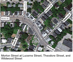 Morton Street in the vicinity of the three intersections experiences high pedestrian activity due to the commercial and residential land uses. There were 438 pedestrian crossings during the two two-hour AM and PM peak periods when MPO staff conducted turning-movement counts at the intersection of Morton Street and Lucerne Street/Leston Street. Forty-eight of these crossings were across Morton Street at its intersection with Lucerne and Leston streets. There is no crosswalk across Morton Street at the Lucerne Street/Leston Street intersection.
All of the intersecting streets had 6-to-8-foot-wide sidewalks on both sides of the streets. There are curb ramps for crossing the side streets. There is a 10-foot-wide marked crosswalk on the north legs of Lucerne Street, Theodore Street, and Wildwood Street, but not on the south legs of Leston Street and Wildwood Street. There is a pedestrian crossing signal on Morton Street in this stretch (just west of Wildwood Street). The pedestrian crossing signal rests on flashing yellow when it is not activated. When activated by a pedestrian using a push button, the pedestrian signal displays red indications to motorists and walk indications to pedestrians. There is a 6-foot-wide median on Morton Street between Theodore Street and Wildwood Street; it is only a 150 feet long. There are no bike lanes on any of the intersecting streets; bicyclists share lanes with motorists.
MBTA bus Route 21 has stops at Wildwood Street, but there are no bus shelters or benches at the stops as they do not meet the eligibility criteria of the MBTA bus shelter installation policy. There are bus stop signs at the stops. Route 21 failed the MBTA loading standard.
The crashes at the three closely spaced intersections were considered one cluster by MassDOT for its crash database; the cluster was not on its 2009 statewide list of the top 200 high-crash intersections. The cluster has an equivalent property damage only (EPDO) rating of 81. Using the PM peak-hour traffic volumes at the intersection, the crash rate was calculated as 1.16 crashes per million entering vehicles (MEV), which exceeds the Highway Division District 6 average crash rate of 0.57 MEV for unsignalized intersections.
MPO staff analyzed crash data from MassDOT’s RMV database that were recorded at the cluster between January 2006 and December 2009 (a four-year period). Of the 36 crashes, 13 were mapped on a collision diagram (in Appendix C). Only the crashes for which crash diagrams had been provided by police were mapped on the collision diagram for this study. Eight of the mapped crashes were angle crashes involving left-turning vehicles; four were single-vehicle crashes; one was a head-on collision: and one was a sideswipe collision. One half of the mapped crashes resulted in nonfatal injuries and there were no fatal injuries. The majority of the angle crashes involved Morton Street westbound traffic and Lucerne Street.
The details of the 36 crashes in terms of severity, manner of collision, and ambient light conditions are:
There was one crash involving a pedestrian.
Table 3-6 presents the results of the intersection capacity analysis. The Synchro outputs are in Appendix E. Based on the results, the intersection operates at LOS C or better during the AM and PM peak hours.
The following problems were identified in the vicinity of the three-intersection cluster:
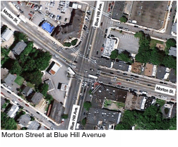 This intersection was the subject of a Road Safety Audit (RSA) undertaken by MassDOT in November 2011. The audit identified potential safety issues at the intersection and opportunities for improvements.10 The reader is encouraged to read the report.
Morton Street at Blue Hill Avenue is a signalized intersection under the jurisdiction of MassDOT. Blue Hill Avenue is a city-owned, north-south multilane principal arterial (two-way, four-lane roadway, with two lanes in each direction). A left-turn lane is provided on each approach of Blue Hill Avenue; but left turns from Morton Street are prohibited. The land uses in the vicinity of the intersection are primarily commercial, including a Mobil gas station on the southwest corner of the intersection and the Boston Police Department District B-3 office is located on the northwest corner of the intersection.
The intersection experiences high pedestrian activity due to the commercial and institutional land uses in the vicinity. Morton Street and Blue Hill Avenue have 6-to-8-foot-wide sidewalks on both sides of each street. There is a 10-foot-wide marked crosswalk on each leg of the intersection, with median cut outs on the north, south, and west legs. Each street corner had curb ramps without detectable warning panels for pedestrians. There are pedestrian signals with pedestrian-activated push buttons for crossing Blue Hill Avenue and Morton Street. Blue Hill Avenue has a bicycle lane in each direction, marked as bike lanes; there is no bike lane on Morton Street.
MBTA bus Routes 21, 28, 29, and 31 have two stops on Morton Street in the vicinity of the intersection: one for the westbound direction and one for the eastbound direction. The performances of these routes are presented in Table 3-4, which indicates that; Routes 21, 29, and 31 fail the loading standard of the MBTA. The two bus stops are heavily utilized, with total daily boardings of 596 and 142 for the westbound and eastbound, respectively. The MBTA has installed bus stop signs at each of these stops, but none of the stops has a bus shelter with a bench, even though the bus stops meet the eligibility criteria of the MBTA bus shelter installation policy.
The traffic signal at the intersection is a combination of post-mounted and overhead signal displays. On Blue Hill Avenue, the overhead and post-mounted signal heads provide good conspicuity and motorists’ line of sight to the signal heads is not blocked by trucks in the traffic stream. On Morton Street, the westbound signal displays are post-mounted in the sidewalks and motorists’ line of sight to the signal heads may be blocked by trucks in the traffic stream.
The signal timing and phase plan for the intersection are included in Appendix B. Left turns are prohibited from Morton Street; Blue Hill Avenue left turns are protected only. Pedestrians at the intersection are serviced with pedestrian-activated exclusive pedestrian phase. A 7-second walk interval and a 15-second flash-don’t-walk (pedestrian clearance time) interval are provided for crossing at the intersection. During field visits, it was observed that the pedestrians do not wait for the walk phase to cross the streets. In addition, the pedestrian clearance time is too short, especially for crossing Blue Hill Avenue. There are no countdown pedestrian timers and no accessible pedestrian signals to assist pedestrians with disabilities at the intersection.
The intersection ranks 185 on MassDOT’s 2009 statewide list of the top 200 high-crash intersections; it had an equivalent property damage only (EPDO) rating of 104. The ranking is based on crashes in the RMV’s crash database for 2007 to 2009. There were 36 crashes in that period (17 injury and 19 property damage only crashes).
Data on crashes that occurred at the intersection for the period April 2008 to September 2011 were analyzed through MassDOT’s Road Safety Audit Program. The crash data, which were obtained from the Boston Police and State Police, showed 33 crashes, 22 of which were mapped on a collision diagram that is included in Appendix E. The intersection had a high number of crashes involving pedestrians; according to the RSA, three of the nine pedestrian crashes involved the same panhandler at the intersection. The RSA indicated that many pedestrians crossing at the intersection do not wait for the walk signal and many do not use the push buttons to activate the pedestrian phase. Pedestrians cross the street concurrently with traffic, which creates conflicts. According to the collision diagram, five of the crashes involved vehicles entering and exiting the Mobil gas station in the southwest corner of the intersection.
Using the PM peak-hour traffic volumes at the intersection, the crash rate was calculated as 0.57 crashes per million entering vehicles (MEV), which is below the Highway Division District 6 average crash rate of 0.77 MEV for signalized intersections. Although this intersection is on the statewide list of the top 200 high-crash intersections, its crash rate is below the District 6 average because of the high volume of vehicles that use the intersection.
Table 3-6 present the results of the Intersection capacity analysis. The Synchro output is included in Appendix E. The analysis indicates that the intersection operates above capacity, vehicles and pedestrians at the intersection experience long delays and traffic queues, and the intersection operates at LOS F during the AM and PM peak hours.
The following problems were identified at the intersection through the MassDOT RSA:
The following additional problems were observed during field visits:
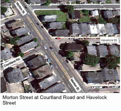 The intersection of Morton Street at Courtland Road and Havelock Street is unsignalized and it is under the jurisdiction of MassDOT. The land use in the vicinity of the intersection is primarily residential. Courtland Road and Havelock Street are city-owned, one-way streets that take traffic away from Morton Street. Courtland Road and Havelock Street are classified as urban collectors. On-street parking is allowed on both sides of the street.
Morton Street is a divided roadway in this stretch, and on-street parking is allowed on both sides of the street. A median opening at the intersection allows left turns from Morton Street onto Courtland Road and Havelock Street. Courtland Road and Havelock Street are cut-through routes for traffic heading to Harvard Street and Blue Hill Avenue, respectively. Courtland Road also serves traffic to the Greendale Road neighborhood.
There are 6-to-8-foot-wide sidewalks on Morton Street, Courtland Road, and Havelock Street. There are curb ramps for pedestrians for the side streets at this intersection, but no marked crosswalks on either Courtland Road or Havelock Street. Bicyclists share the travel lanes with motorists on Morton Street. There is no bus stop at the intersection; the closest bus stop is at the intersection of Morton Street and Harvard Road, about 200 feet to the west.
The intersection is not on MassDOT’s 2009 statewide list of the top 200 high-crash intersections. It has an equivalent property damage only (EPDO) rating of 54, based on MassDOT crash data for the period 2007 to 2009.
Crash data that occurred at the intersection for the period July 2008 to September 2011 were analyzed through MassDOT’s Road Safety Audit Program. The crash data, which were obtained from the Boston Police and State Police, showed 20 crashes, 19 of which were mapped on a collision diagram that is included in Appendix C. According to the collision diagram, the majority of the crashes were angle-type collisions involving Morton Street vehicles turning left onto Courtland Road.
Using the PM peak-hour traffic volumes at the intersection, the crash rate was calculated as 0.72 crashes per million entering vehicles (MEV), which exceeds the Highway Division District 6 average crash rate of 0.57 MEV for unsignalized intersections.
Table 3-6 presents the results of the intersection capacity analyses. The Synchro output of the intersection capacity analyses is included in Appendix E. Based on the results, there is no delay or queuing at the intersection; the intersection operates at LOS C or better during the AM and PM peak hours.
The following problems were identified at the intersection through the RSA:
4 Massachusetts Bay Transportation Authority, Service Delivery Policy, June 2, 2010 (available at the MBTA’s website).
5 An equivalent property damage only (EPDO) rating is calculated by georeferencing the crashes in the MassDOT database to clusters around intersections and using a weighting system in which a fatal crash is weighted 10 times, an injury 5 times, and a property-damage- only 1 times.
6 Crashes that were mapped on collision diagrams had diagrams of crashes prepared by a State Police or Boston Police officer.
7 MassDOT Highway Division’s preference is the PM Peak hour volume, however, the AM Peak is acceptable if it is the only data available.
8 Trafficware Inc., Synchro Studio 8, Synchro plus SimTraffic, Build 801, Version 563, Sugar Land, Texas.
9 Boston Region MPO Safe Access to Transit for Pedestrians and Bicyclists study, FFY 2012.
10 Massachusetts Department of Transportation, Highway Division, Road Safety Audit, Morton Street at Blue Hill Avenue, Morton Street at Courtland Road/Havelock Street, Morton Street at Harvard Street, City of Boston (Mattapan), January 20, 2012.
There are four projects planned or proposed for the Gallivan Boulevard and Morton Street arterial segments.
This project is programmed in the Boston Region MPO’s Federal Fiscal Year 2012 Transportation Improvement Program (TIP). It is currently in the design phase, and construction is expected to begin in spring 2013. The work for this project consists of the replacement of the Morton Street bridge, which goes over the MBTA and CSX Railroad tracks. The work will include complete replacement of the superstructure and construction of new abutments in front of the existing abutments and behind the existing piers. The existing piers will be demolished. The new bridge will be a single-span, continuous composite steel stringer superstructure, with a concrete deck. The substructure will consist of full-height abutments with spread footings founded on bedrock. The approach roadways will be reconstructed approximately 200 feet on either side of the bridge.
The proposed project would consist of traffic signal improvements and upgrades and possible lane configuration changes to better manage traffic at this intersection, which was formerly under the jurisdiction of the Department of Conservation and Recreation (DCR), until it was transferred to MassDOT’s jurisdiction in 2009. In connection with this project, the intersection of Morton Street and Gallivan Boulevard was studied by TranSystems Corporation.11 In its intersection alternatives design report, TranSystems’ recommended alternative is to signalize the existing intersection, which would meet the goals of the project and garner the most support from the public. The proposed signal is expected to reduce delay at the intersections as well as improve safety for all users.
This proposed project would include improvements to Gallivan Boulevard, which was transferred from DCR to MassDOT in 2009. The project limits are from Neponset Circle to just east of the Morton Street intersection. Improvements could include resurfacing the roadway, upgrading the traffic signal system, upgrading the sidewalks, reconfiguring the roadway, bringing the intersection up to ADA accessibility standards, adding transit amenities, and implementing pedestrian and bicycle accommodations. The project is in the preliminary study and design phase; this planning study constitutes part of the planning and preliminary design phase. Project need and initiation forms were submitted in March 2012 and were approved by MassDOT’s project review committee (PRC) in the same month. There is no current funding for the proposed project; therefore, the likely timing of the MassDOT project is 8 to 10 years from now.
This proposed project would include improvements to Morton Street from west of the Gallivan Boulevard and Morton Street intersection to Shea Circle. Improvements could include resurfacing, sidewalk upgrades, ADA compliance, transit amenities, and pedestrian and bicycle facilities. The project is in preliminary study and design phase, and this planning study will be used as part of the planning and preliminary design phase. Project need and initiation forms were submitted for this study in March 2012 and were approved by the PRC in the same month. There is no current funding for the proposed corridor projects; therefore, the likely timing of the MassDOT projects is 8-10 years from now.
To forecast, on a systematic basis, future traffic volume changes resulting from changes in the transportation network or in land use, a planning model is used. The transportation planning model used in this study is the Boston Region MPO’s most-recently adopted regional travel demand model set. Its socioeconomic components are based on forecasts produced by the Metropolitan Area Planning Council. The model is calibrated at a regional level for 164 cities and towns, which include all of the 101 cities and towns in the MPO region.
For site-specific development and transportation projects, the model has to be calibrated to replicate local travel patterns in the project area before it is used to forecast the future impacts of a project. The primary tool used in model calibration is the transportation planning model set implemented in EMME software.12 For the present study, the regional model network was customized for the study area by making several enhancements to the input data before calibration.
Table 4-1 presents the projected growth in peak-period traffic volumes for the Gallivan Boulevard and Morton Street corridors between 2009 and 2020. The volumes are three-hour peak-period volumes (6:00 AM–9:00 AM and 3:00 PM–6:00 PM). Locations with negative growth between year 2009 and year 2020 are associated with negative growth in socioeconomic data (population and employment) in the nearby transportation analysis zones.
The projected growth factors from the regional model set were used to expand the existing peak-hour turning-movement volumes to 2020 future turning-movement volumes (Figure 4-1). MPO staff performed year 2020 intersection capacity analyses by using Synchro 8 traffic operations analysis software and the projected traffic volumes.13
TABLE 4-1
Peak-Period Traffic Volume Changes along Route 203
between 2009 and 2020
Location |
|
2009 Volume |
|
2020 Volume |
|
Growth |
|||
|
AM |
PM |
|
AM |
PM |
|
AM |
PM |
|
Morton Street Eastbound |
|||||||||
East of Harvard Street |
|
2,261 |
4,718 |
|
2,324 |
4,868 |
|
2.8% |
3.2% |
West of Blue Hill Avenue |
|
2,267 |
4,418 |
|
2,333 |
4,545 |
|
2.9% |
2.9% |
East of Blue Hill Avenue |
|
2,007 |
4,008 |
|
2,100 |
4,120 |
|
4.7% |
2.8% |
West of Norfolk Street |
|
2,148 |
4,008 |
|
2,253 |
4,097 |
|
4.9% |
2.2% |
East of Norfolk Street |
|
1,943 |
3,802 |
|
2,050 |
4,045 |
|
5.5% |
6.4% |
West of Gallivan Boulevard |
|
2,008 |
3,698 |
|
2,119 |
3,929 |
|
5.5% |
6.2% |
Subtotal |
|
12,633 |
24,652 |
|
13,180 |
25,603 |
|
4.3% |
3.9% |
|
|||||||||
Morton Street Westbound |
|||||||||
East of Harvard Street |
|
4,784 |
3,387 |
|
4,781 |
3,682 |
|
-0.1% |
8.7% |
West of Blue Hill Avenue |
|
4,466 |
3,322 |
|
4,447 |
3,598 |
|
-0.4% |
8.3% |
East of Blue Hill Avenue |
|
3,795 |
2,590 |
|
3,709 |
2,913 |
|
-2.3% |
12.5% |
West of Norfolk Street |
|
3,721 |
2,701 |
|
3,636 |
2,994 |
|
-2.3% |
10.8% |
East of Norfolk Street |
|
3,321 |
2,418 |
|
3,297 |
2,845 |
|
-0.7% |
17.7% |
West of Gallivan Boulevard |
|
3,166 |
2,435 |
|
3,117 |
2,864 |
|
-1.5% |
17.6% |
Subtotal |
|
23,253 |
16,853 |
|
22,987 |
18,896 |
|
-1.1% |
12.1% |
|
|||||||||
Gallivan Boulevard Eastbound |
|||||||||
West of Washington Street |
|
1,102 |
1,920 |
|
1,160 |
2,166 |
|
5.2% |
12.8% |
Between Washington Street and Dorchester Avenue |
|
1,613 |
2,386 |
|
1,672 |
2,580 |
|
3.7% |
8.1% |
Between Dorchester Avenue and Adams Street |
|
1,503 |
2,171 |
|
1,529 |
2,368 |
|
1.8% |
9.1% |
East of Adams Street |
|
2,955 |
3,792 |
|
3,048 |
4,043 |
|
3.1% |
6.6% |
West of Granite Avenue |
|
2,929 |
3,776 |
|
3,019 |
4,029 |
|
3.1% |
6.7% |
Subtotal |
|
10,102 |
14,044 |
|
10,429 |
15,186 |
|
3.2% |
8.1% |
|
|||||||||
Gallivan Boulevard Westbound |
|||||||||
West of Washington Street |
|
872 |
1,285 |
|
892 |
1,612 |
|
2.3% |
25.4% |
Between Washington Street and Dorchester Avenue |
|
1,229 |
2,037 |
|
1,222 |
2,330 |
|
-0.5% |
14.4% |
Between Dorchester Avenue and Adams Street |
|
850 |
2,057 |
|
842 |
2,297 |
|
-1.0% |
11.7% |
East of Adams Street |
|
2,587 |
3,595 |
|
2,584 |
3,927 |
|
-0.1% |
9.2% |
West of Granite Avenue |
|
2,577 |
3,581 |
|
2,573 |
3,908 |
|
-0.2% |
9.1% |
Subtotal |
|
8,115 |
12,555 |
|
8,113 |
14,074 |
|
0.0% |
12.1% |
Note: Modeling results are output from model runs made for the MPO’s current Long-Range Transportation Plan, Paths to a Sustainable Region, adopted by the MPO on September 22, 2011. The volumes are three-hour peak period volumes (6:00 AM – 9:00 AM and 3:00 PM – 6:00PM).
A summary of the results is provided in Tables 4-2 and 4-3. Synchro outputs of the year 2020 capacity analyses are included in Appendix E.
The anticipated future operating levels of service were estimated based on the projected 2020 traffic conditions with and without improvements. The future conditions without improvements identify how the traffic conditions along the Gallivan Boulevard and Morton Street segments of Route 203 are expected to degrade over time if no improvements are made to the infrastructure. This scenario includes the future traffic volumes using the existing roadway configuration (a four-lane cross-section) with existing traffic signal settings. The year 2020 scenario with improvements includes the future traffic volumes on a modified roadway configuration (four-lane cross-section) with geometric changes and optimized signal timings.
Tables 4-2 and 4-3 show that traffic operations at the following signalized intersections are expected to degrade over time as the traffic volume increases:
The improvements proposed for the Gallivan Boulevard and Morton Street arterial segments were developed from the following inputs:
Suggestions included in comments received from the neighborhood, WalkBoston, and MassBike on a Morton Street road safety audit conducted by MassDOT.14
TABLE 4-2
2020 AM and PM Peak-Hour Level of Service without Improvements
Approach |
Move- ment |
|
2020 AM |
|
2020 PM |
||||
|
LOS |
Delay1 |
Queue2 |
|
LOS |
Delay |
Queue |
||
Gallivan Blvd. EB |
L+T+R |
|
F |
209 |
#943 |
|
F |
321 |
#896 |
Gallivan Blvd. WB |
L+T+R |
|
D |
40 |
#277 |
|
F |
303 |
#560 |
Granite Ave. NB |
L |
|
E |
59 |
#441 |
|
F |
128 |
#497 |
Granite Ave. NB |
T+R |
|
E |
78 |
#587 |
|
F |
159 |
#585 |
Adams St. SB |
L |
|
C |
30 |
77 |
|
D |
47 |
135 |
Adams St. SB |
T |
|
D |
42 |
270 |
|
E |
72 |
#394 |
Adams St. SB |
R |
|
C |
34 |
95 |
|
D |
41 |
88 |
|
|
|
|
|
|
|
|
|
|
Gallivan Blvd. EB |
L+T+R |
|
F |
87 |
#382 |
|
E |
80 |
#342 |
Gallivan Blvd. WB |
L+T+R |
|
D |
41 |
#288 |
|
D |
55 |
#276 |
Dorchester Ave. NB |
L+T+R |
|
D |
39 |
#369 |
|
E |
71 |
#369 |
Dorchester Ave. SB |
L+T+R |
|
C |
28 |
#294 |
|
F |
207 |
#498 |
|
|
|
|
|
|
|
|
|
|
Gallivan Blvd. EB |
L+T+R |
|
C |
26 |
#282 |
|
C |
25 |
#331 |
Gallivan Blvd. WB |
L+T+R |
|
C |
21 |
217 |
|
C |
29 |
#367 |
Washington St. NB |
L+T+R |
|
C |
31 |
#508 |
|
C |
27 |
245 |
Washington St. SB |
L+T+R |
|
B |
18 |
165 |
|
D |
44 |
#378 |
|
|
|
|
|
|
|
|
|
|
Morton St. EB |
L+T+R |
|
C |
29 |
#342 |
|
F |
88 |
#558 |
Morton St. WB |
L+T+R |
|
D |
36 |
#443 |
|
F |
131 |
#518 |
West Selden St. NB |
L+T+R |
|
D |
38 |
176 |
|
D |
32 |
137 |
Selden St. SB |
L+T+R |
|
C |
31 |
94 |
|
D |
31 |
139 |
|
|
|
|
|
|
|
|
|
|
Morton St. EB |
T |
|
A |
0 |
0 |
|
A |
0 |
0 |
Morton St. WB |
T |
|
A |
0 |
0 |
|
A |
0 |
0 |
Leston St. NB |
L+T+R |
|
B |
20 |
20 |
|
B |
12 |
20 |
Lucerne St. SB |
L+T+R |
|
B |
20 |
20 |
|
C |
17 |
20 |
|
|
|
|
|
|
|
|
|
|
Morton St. EB |
T+R |
|
E |
89 |
#619 |
|
F |
212 |
#912 |
Morton St. WB |
T+R |
|
F |
131 |
#732 |
|
F |
220 |
#678 |
Blue Hill Ave. NB |
L |
|
F |
264 |
#617 |
|
F |
124 |
#425 |
Blue Hill Ave. NB |
T+R |
|
F |
83 |
#693 |
|
E |
62 |
#456 |
Blue Hill Ave. SB |
L |
|
E |
66 |
159 |
|
F |
105 |
#389 |
Blue Hill Ave. SB |
T+R |
|
E |
48 |
261 |
|
F |
116 |
#651 |
|
|
|
|
|
|
|
|
|
|
Morton St. EB |
L+T+R |
|
A |
3 |
20 |
|
A |
8 |
31 |
Morton St. WB |
L+T+R |
|
A |
6 |
20 |
|
A |
6 |
20 |
Courtland Rd. |
NA |
|
NA |
NA |
NA |
|
NA |
NA |
NA |
Havelock St. |
NA |
|
NA |
NA |
NA |
|
NA |
NA |
NA |
1 Delay in seconds per vehicle.
2 95th percentile queue length in feet.
# means that the 95th percentile volume exceeds capacity.
Note: Shading denotes street approaches with delay and queuing problems.
TABLE 4-3
2020 AM and PM Peak-Hour Level of Service with Improvements
Approach |
Move-ment |
|
2020 AM |
|
2020 PM |
||||
|
LOS |
Delay1 |
Queue2 |
|
LOS |
Delay |
Queue |
||
Gallivan Blvd. EB |
L+T+R |
|
D |
51 |
#590 |
|
E |
77 |
#580 |
Gallivan Blvd. WB |
L+T+R |
|
C |
22 |
169 |
|
D |
43 |
#350 |
Granite Ave. NB |
L |
|
E |
77 |
#311 |
|
E |
79 |
#338 |
Granite Ave. NB |
T+R |
|
D |
49 |
#424 |
|
D |
48 |
#391 |
Adams St. SB |
L |
|
D |
37 |
#56 |
|
D |
43 |
91 |
Adams St. SB |
T |
|
D |
48 |
#205 |
|
E |
59 |
#325 |
Adams St. SB |
R |
|
C |
34 |
105 |
|
C |
32 |
131 |
|
|
|
|
|
|
|
|
|
|
Gallivan Blvd. EB |
L+T+R |
|
D |
37 |
#423 |
|
E |
66 |
#413 |
Gallivan Blvd. WB |
L+T+R |
|
C |
29 |
#303 |
|
D |
50 |
#328 |
Dorchester Ave. NB |
L+T+R |
|
D |
51 |
#420 |
|
D |
41 |
#409 |
Dorchester Ave. SB |
L+T+R |
|
D |
38 |
#334 |
|
F |
122 |
#582 |
|
|
|
|
|
|
|
|
|
|
Gallivan Blvd. EB |
L+T+R |
|
C |
24 |
#305 |
|
C |
21 |
#303 |
Gallivan Blvd. WB |
L+T+R |
|
B |
18 |
#235 |
|
C |
23 |
#356 |
Washington St. NB |
L |
|
B |
14 |
35 |
|
C |
26 |
47 |
Washington St. NB |
T+R |
|
C |
32 |
#473 |
|
C |
30 |
#228 |
Washington St. SB |
L |
|
C |
16 |
76 |
|
C |
27 |
107 |
Washington St. SB |
T+R |
|
B |
16 |
#151 |
|
D |
41 |
#333 |
|
|
|
|
|
|
|
|
|
|
Morton St. EB |
L+T+R |
|
C |
30 |
#366 |
|
C |
30 |
#567 |
Morton St. WB |
L+T+R |
|
C |
33 |
#473 |
|
D |
42 |
#540 |
West Selden St. NB |
L+T+R |
|
D |
44 |
#186 |
|
D |
45 |
169 |
Selden St. SB |
L+T+R |
|
D |
35 |
#102 |
|
D |
46 |
173 |
|
|
|
|
|
|
|
|
|
|
Morton St. EB |
T |
|
A |
0 |
0 |
|
A |
0 |
0 |
Morton St. WB |
T |
|
A |
0 |
0 |
|
A |
0 |
0 |
Leston St. NB |
L+T+R |
|
B |
10 |
20 |
|
B |
12 |
20 |
Lucerne St. SB |
L+T+R |
|
B |
15 |
20 |
|
B |
14 |
20 |
|
|
|
|
|
|
|
|
|
|
Morton St. EB |
T+R |
|
D |
41 |
446 |
|
E |
66 |
#646 |
Morton St. WB |
T+R |
|
D |
51 |
#564 |
|
D |
43 |
#440 |
Blue Hill Ave. NB |
L |
|
E |
67 |
#423 |
|
E |
69 |
#319 |
Blue Hill Ave. NB |
T+R |
|
D |
37 |
#467 |
|
D |
45 |
#354 |
Blue Hill Ave. SB |
L |
|
D |
55 |
143 |
|
D |
54 |
#278 |
Blue Hill Ave. SB |
T+R |
|
D |
40 |
234 |
|
E |
68 |
#511 |
|
|
|
|
|
|
|
|
|
|
Morton St. EB |
L+T+R |
|
A |
3 |
20 |
|
A |
4 |
25 |
Morton St. WB |
L+T+R |
|
A |
6 |
20 |
|
A |
4 |
25 |
Courtland Rd. |
NA |
|
NA |
NA |
NA |
|
NA |
NA |
NA |
Havelock St. |
NA |
|
NA |
NA |
NA |
|
NA |
NA |
NA |
1 Delay in seconds per vehicle.
2 95th-percentile queue length in feet.
# means that the 95th percentile volume exceeds capacity.
Note: Shading denotes street approaches with delay and queuing problems.
The proposed Improvements were categorized into three categories:
The following improvements are proposed for the Gallivan Boulevard segment (shown in Figure 4-2).

MPO staff suggest that a road diet should be considered for the section of Gallivan Boulevard between Wilmington Avenue and Wessex Street. This segment of Gallivan Boulevard has low average daily traffic (ADT) volumes (between 14,000 and 20,000 vehicles per day). Applying a road diet and reducing the number of travel lanes to two (one in each direction) on Gallivan Boulevard would allow:
In addition, a road diet would have multiple safety and operational benefits for vehicles and pedestrians in the Gallivan Boulevard segment, such as:
TABLE 4-4
2020 AM and PM Peak-Hour Level of Service with Road Diet
Approach |
Move-ment |
|
2020 AM |
|
2020 PM |
||||
|
LOS |
Delay1 |
Queue2 |
|
LOS |
Delay |
Queue |
||
Gallivan Blvd. EB |
L+T+R |
|
D |
51 |
#590 |
|
E |
77 |
#580 |
Gallivan Blvd. WB |
L+T+R |
|
C |
22 |
169 |
|
D |
43 |
#350 |
Granite Ave. NB |
L |
|
E |
77 |
#311 |
|
E |
79 |
#338 |
Granite Ave. NB |
T+R |
|
D |
49 |
#424 |
|
D |
48 |
#391 |
Adams St. SB |
L |
|
D |
37 |
#56 |
|
D |
43 |
91 |
Adams St. SB |
T |
|
D |
48 |
#205 |
|
E |
59 |
#325 |
Adams St. SB |
R |
|
C |
34 |
105 |
|
C |
32 |
131 |
|
|
|
|
|
|
|
|
|
|
Gallivan Blvd. EB |
L |
|
C |
23 |
108 |
|
C |
26 |
33 |
Gallivan Blvd. EB |
T+R |
|
F |
108 |
#883 |
|
F |
170 |
#837 |
Gallivan Blvd. WB |
L |
|
F |
113 |
146 |
|
F |
119 |
139 |
Gallivan Blvd. WB |
T+R |
|
F |
203 |
#774 |
|
F |
132 |
#771 |
Dorchester Ave. NB |
L+T+R |
|
D |
44 |
#418 |
|
D |
44 |
#411 |
Dorchester Ave. SB |
L+T+R |
|
D |
35 |
#330 |
|
F |
134 |
#584 |
|
|
|
|
|
|
|
|
|
|
Gallivan Blvd. EB |
L |
|
C |
29 |
121 |
|
C |
21 |
89 |
Gallivan Blvd. EB |
T+R |
|
E |
59 |
#566 |
|
D |
48 |
776 |
Gallivan Blvd. WB |
L |
|
B |
15 |
29 |
|
D |
49 |
126 |
Gallivan Blvd. WB |
T+R |
|
E |
62 |
#568 |
|
D |
48 |
#767 |
Washington St. NB |
L |
|
B |
14 |
34 |
|
C |
27 |
47 |
Washington St. NB |
T+R |
|
C |
32 |
#458 |
|
C |
32 |
#228 |
Washington St. SB |
L |
|
C |
16 |
73 |
|
C |
30 |
108 |
Washington St. SB |
T+R |
|
B |
16 |
#146 |
|
D |
45 |
#333 |
|
|
|
|
|
|
|
|
|
|
Morton St. EB |
L+T+R |
|
C |
30 |
#366 |
|
C |
30 |
#567 |
Morton St. WB |
L+T+R |
|
C |
33 |
#473 |
|
D |
42 |
#540 |
West Selden St. NB |
L+T+R |
|
D |
44 |
#186 |
|
D |
45 |
169 |
Selden St. SB |
L+T+R |
|
D |
35 |
#102 |
|
D |
46 |
173 |
|
|
|
|
|
|
|
|
|
|
Morton St. EB |
T |
|
A |
0 |
0 |
|
A |
0 |
0 |
Morton St. WB |
T |
|
A |
0 |
0 |
|
A |
0 |
0 |
Leston St. NB |
L+T+R |
|
B |
10 |
20 |
|
B |
12 |
20 |
Lucerne St. SB |
L+T+R |
|
B |
15 |
20 |
|
B |
14 |
20 |
|
|
|
|
|
|
|
|
|
|
Morton St. EB |
T+R |
|
D |
41 |
446 |
|
E |
66 |
#646 |
Morton St. WB |
T+R |
|
D |
51 |
#564 |
|
D |
43 |
#440 |
Blue Hill Ave. NB |
L |
|
E |
67 |
#423 |
|
E |
69 |
#319 |
Blue Hill Ave. NB |
T+R |
|
D |
37 |
#467 |
|
D |
45 |
#354 |
Blue Hill Ave. SB |
L |
|
D |
55 |
143 |
|
D |
54 |
#278 |
Blue Hill Ave. SB |
T+R |
|
D |
40 |
234 |
|
E |
68 |
#511 |
|
|
|
|
|
|
|
|
|
|
Morton St. EB |
L+T+R |
|
A |
3 |
20 |
|
A |
4 |
25 |
Morton St. WB |
L+T+R |
|
A |
6 |
20 |
|
A |
4 |
25 |
Courtland Rd. |
NA |
|
NA |
NA |
NA |
|
NA |
NA |
NA |
Havelock St. |
NA |
|
NA |
NA |
NA |
|
NA |
NA |
NA |
1 Delay in seconds per vehicle.
2 95th-percentile queue length in feet.
# means that the 95th percentile volume exceeds capacity.
Note: Shading denotes street approaches with delay and queuing problems.
Many of the proposed improvements for accommodating pedestrian and bicyclists and making traffic operations efficient would also help transit users and improve schedule adherence for buses, such as:
In addition, MPO staff recommend that bus shelters with benches and trash receptacles be provided at two bus stops on Gallivan Boulevard. A review of CTPS bus stop data collected in 2007–09 shows that two bus stops in the Gallivan Boulevard segment have total daily boardings of 70 passengers or greater; those two stops are:
Ensure that adequate lighting is provided to increase safety and security, especially at the following locations: signalized intersections, bus stop locations, and commercial areas. Upgrade street lighting in the Gallivan Boulevard segment by repairing or replacing:
Replace damaged and dead trees, and plant trees in new locations that would benefit from having trees.
The following improvements are proposed for the Morton Street segment (shown in Figure 4-3).

 Install R10-11a signs (No Turn on Red) at signalized intersections with exclusive pedestrian phases.
 As in the Gallivan Boulevard segment, many of the proposed improvements for accommodating pedestrians and bicyclists and making traffic operations more efficient in the Morton Street segment would also help transit users and improve schedule adherence for buses. Some of these improvements are:
In addition, MPO staff recommend that bus shelters with benches and trash receptacles be considered at the eight bus stops on Morton Street that meet the eligibility criteria for shelter installation. Those eight stops are:
In addition, transit priority should be considered for the Morton Street segment to allow approaching buses to place a call to provide a green phase or receive a leading green. This should be carefully considered, along with other potential phasing and timing improvements, and may be complicated by the existing near-side bus stops on the Morton Street, as an approaching bus would place a priority call when it is in fact intending to stop to pick up or discharge passengers before traveling through the intersection. This improvement would require cooperation from the City of Boston and the MBTA.
Upgrade street lighting in the segment by repairing or replacing:
The proposed improvements at seven intersections that were selected for study are summarized below.
The following improvements are proposed for this intersection (shown in Figure 4-4).

 Install bicycle detection devices (loop or video) and bicycle detector pavement markings at the intersection.
The following improvements are proposed for this intersection (shown in Figure 4-5).

Three improvement options were developed for this intersection:
Option 1: Make geometric improvements at the Driscoll Drive approach to channelize its traffic to Washington Street, and restripe the Washington Street approaches to add a left-turn bay, as shown in Figure 4-6.
Option 2: Make geometric improvements at the Driscoll Drive approach to tie it into the intersection directly and provide it with a separate traffic signal phase, as shown in Figure 4-7.
Option 3: Reverse the direction of Driscoll Drive to be away from the intersection.
In addition to the three options described above, the following general improvements are proposed for the intersections:


The following improvements are proposed for this intersection (shown in Figure 4-8).
The following improvements are proposed for this intersection (shown in Figure 4-9).
The following improvements are proposed for this intersection (shown in Figure 4-10).


 Provide accessible pedestrian signals (APS) at the signalized intersections.
The following improvements are proposed for this intersection (shown in Figure 4-11).
Based on preliminary cost estimates, the improvements proposed for Gallivan Boulevard and Morton Street, including upgrading pedestrian and bicycle facilities upgrading traffic signal equipment, adding Opticom system, updating the traffic signal timing, making geometric modifications, improving bus transit service, improving signage, rehabilitating and reconstructing pavement (as necessary), implementing median and landscaping treatments, and upgrading the street lighting would cost $6-7 million for the Gallivan segment and another $6-7 million for the Morton Street segment.
There are two MassDOT reconstruction projects proposed for Route 203: one for reconstructing Gallivan Boulevard (MassDOT Project ID #606896) and one for reconstructing Morton Street (MassDOT Project ID #606897). These projects are described in subsections 4.1.3 and 4.1.4 of this report. Project need and initiation forms have been completed and approved by MassDOT’s project review committee for these two projects. Currently the two projects are in preliminary design and planning phases and this planning study is part of these phases.
There is currently no funding for these projects; therefore, the likely timing of the MassDOT project is 8 to 10 years from now. MPO staff suggest that MassDOT implement the key short-term improvements through maintenance funds. The medium-term improvements should be implemented when funding becomes available for the projects.

11 Massachusetts Department of Transportation, Intersection Design Report, Intersection Improvement Project: Morton Street at Gallivan Boulevard, Boston, Massachusetts, June 2012.
12 EMME 3, Transport Modeling, INRO, Westmount, Montreal, Quebec, Canada.
13 Trafficware Inc., Synchro Studio 8, Snychro plus SimTraffic, Build 801, Version 563, Sugar Land, Texas.
14 Road Safety Audit, Morton Street at Blue Hill Avenue, Morton Street at Courtland Road/Havelock Street, Morton Street at Harvard Street, City of Boston (Mattapan), Massachusetts Department of Transportation, Highway Division, January 20, 2012.
15 Rhythm Engineering, InSync Adaptive Signal Control System, Lenexa, Kansas 66215.