
Technical Memorandum
DATE: December 6, 2018
TO: James Kupfer and Donald DiMartino, Town of Bellingham
FROM: Seth Asante and Benjamin Erban, MPO Staff
RE: Redesign of Hartford Avenue and Maple Street Intersection
This memorandum summarizes the analyses and improvement strategies for the intersection of Hartford Avenue (Route 126) and Maple Street in Bellingham.
The memorandum contains the following sections:
2. Existing Facilities and Land Uses
4. Existing Traffic Conditions
6. Existing Traffic Operations
It also includes technical appendices that contain data and methods applied in the study.
The purpose of the Safety and Operations Analyses at Selected Intersections study is to examine safety, operations, and mobility issues at major intersections in the Boston Region Metropolitan Planning Organization (MPO) region’s arterial highways—areas where many crashes occur, that experience congestion during peak traffic periods, or are in need of improvements to accommodate heavy vehicles (buses and trucks) or nonnotarized transportation (bicyclists and pedestrians). For the past 10 years, the MPO has conducted these planning studies, which have been well received by the municipalities in the region. These studies give communities an opportunity to look at the needs of the select locations, starting at the conceptual level, before they commit funds for design and engineering. Eventually, if the project qualifies for federal funds, the study’s documentation also is useful to the Massachusetts Department of Transportation (MassDOT). These studies support the MPO’s visions and goals, which include increasing transportation safety, maintaining the transportation system, advancing mobility, and reducing congestion.
Following a selection process based on safety conditions, congested conditions, multimodal significance, regional significance, regional equity, and implementation potential, the following two locations from a short list of 20 intersections were approved for study by the MPO. 1 ,2 ,3 , 4,5 , 6, 7
The location in Bellingham was selected because the intersection at Hartford Avenue and Maple Street carries a high proportion of truck traffic and is undersized to accommodate large commercial vehicles safely and efficiently. The intersection is just one-half mile east of the interchange of Interstate 495 and Route 126, where a number of large commercial uses exist. In addition, the area along Maple Street is zoned for industrial uses and currently home to several businesses and industrial properties (a power plant, multiple warehouses exceeding 600,000 square feet of space, and large-scale mulch and lumber hauling and production). The Town of Bellingham recognizes the need to upgrade the intersection in order to maintain the industrial uses and unlock future investment potential of the surrounding area, which is projected to grow in the future. Figure 1 shows the location of the intersection and the surrounding roadways.
1 Safety Conditions: Location has a higher-than-average crash rate for its functional class, contains a Highway Safety Improvement Program (HSIP)-eligible crash cluster, contains a top-200 high crash location, or has a significant number of pedestrian and bicycle crashes (two or more per mile).
2 Congested Conditions: Travel time index is at least 1.3.
3 Multimodal Significance: Location carries bus route(s), is adjacent to a transit stop or station; supports bicycle or pedestrian activities or has an implementation project to support one or more of these activities; has need to accommodate pedestrians and bicyclists and improve transit; or high truck traffic serving regional commerce.
4 Regional Significance: Location is in National Highway System; carries a significant portion of regional traffic (ADT >20,000); lies within 0.5 miles of Environmental Justice transportation analysis areas or zones; or is essential for the region’s economic, cultural, or recreational development.
5 Regional Equity: That is, it was important not to select 1) more than one location in a subregion and 2) a location in same subregion as in the preceding cycle of this study.
6 Implementation Potential: Location is proposed or endorsed by its roadway administrative agency (agencies); proposed or endorsed by its subregion and is a priority for that subregion; or has strong support from other stakeholders.
7 Safety and Operations Analyses at Selected Intersections: Federal Fiscal Year 2018, Technical Memorandum to the Boston Region Metropolitan Planning Organization. Seth Asante and Chen-Yuan Wang, January 18, 2018.

MPO staff discussed the safety and operations issues at the intersection and the scope of work for the study with the Town of Bellingham, which expressed interest and willingness to participate in the study. An advisory task force—composed of representatives from the Town of Bellingham, MassDOT District 3, and MassDOT Office of Transportation Planning (OTP)—was established to guide this study. MPO staff met with the task force twice. The first meeting focused on the work scope and existing problems. In the second meeting, MPO staff presented the existing conditions, analyses, proposed improvements, and received advice from the task force members. This report reflects the task force’s feedback. Appendix A includes a list of task force members, information about the selection process, and comments about the study.
The study intersection is located in the northeast corner of the Town of Bellingham, approximately one-half mile north of Exit 18 off of I-495. Hartford Avenue (Route 126) intersects with the northern terminus of Maple Street at a traffic signal. Route 126 is classified as a principal arterial (other) and is a town-accepted roadway despite being a numbered route. Both streets are two-lane, two-way roadways. The right-of-way of Hartford Avenue is 60 feet and the right-of-way of Maple Street is about 47 feet. Figure 2 shows the existing intersection geometry.
The property on the northeast corner of the intersection is owned by the Town of Bellingham and is currently used as an auxiliary garage for the Bellingham Fire Department. The property on the southeast corner of the intersection, 3 Maple Street, is a private residence. On the west side of Hartford Avenue are several small businesses, as well as Stall Brook Elementary School and Bellingham Early Childhood Center. The school has 19 classrooms and serves 325 students. Stall Brook School may be accessed via an unsignalized driveway that enters the study intersection, although traffic counts show that the vast majority of school traffic uses a second unsignalized driveway about 200 feet north of the intersection.
While the properties adjacent to the intersection are mostly residential and commercial, the surrounding area—particularly further down Maple Street—has a significant amount of land zoned industrial. Figure 3 gives a map of the zoning in the vicinity of the intersection and notes several existing or planned industrial businesses.


The primary issue at this intersection is truck maneuvers to and from Maple Street. Heavy vehicles have difficulty making left and right turns in the intersection. Taking a right from Hartford Avenue northbound onto Maple Street is the shortest route to access Maple Street from I-495, although the turn onto Maple Street is difficult for trucks because of a substandard curb radius. Figure 4 shows the telephone pole on the southeast corner of the intersection, which is frequently damaged by trucks making a right turn onto Maple Street from Route 126 northbound. The left turn out of Maple Street is also difficult, and heavy vehicles leaving Maple Street properties are technically required to head south to Mechanic Street (Route 140) instead of using the Hartford Avenue and Maple Street intersection, which is an inconvenience. Most of the complaints from residents about this intersection relate to the turning of large heavy vehicles.
Figure 4
Telephone Pole in front of 3 Maple Street

Maple Street already sees a high volume of truck traffic as a consequence of the existing industrial properties (shown in Figure 3), and the corridor is primed for further growth in the near future. Many of the industrial-zoned properties along Maple Street are either undeveloped (woodland or swamp) or underdeveloped properties where new businesses have expressed interest. Planned industrial projects include a new 450,000 square foot industrial warehouse currently under construction across the street from a dog daycare center, Camp Bow Wow, as well as a second warehouse further down the corridor. Additionally, the Maplegate Country Club, which spans the border with Franklin, recently changed ownership and potentially could be redeveloped, freeing up a large area for industrial development.
This area is in high demand because it is one of the few suitable sites for warehouses near I-495. In addition, its location near the Massachusetts border makes it a good stopover point for redistributing loads to meet weight regulations in Connecticut and Rhode Island. Several mulch distributors on Maple Street currently take advantage of this strategic placement.
Addressing issues at the intersection of Hartford Avenue and Maple Street is of particular interest because the intersection is the limiting factor for further development along Maple Street. The Town of Bellingham has previously made several investments in Maple Street. A redesign of the intersection at the other end of Maple Street (with Route 140) is already planned, with design work provided by the traffic consultant BETA Group and funding from both MassWorks grants and a private developer. Bellingham has spent $1.0 million on Maple Street itself to improve drainage, widen shoulders, and repair wear and tear from heavy vehicle traffic. Kleinfelder was the design contractor for this work.
In summary, addressing issues caused by heavy vehicles at the study intersection will improve safety for residents and drivers, improve access and convenience for businesses, and help the town meet its vision of a profitable industrial corridor along Maple Street.
MassDOT Highway Division’s Traffic Data Collection section conducted automatic traffic recorder (ATR) counts over a two-day period from Monday February 12, 2018, to Wednesday February 14, 2018. The counts continuously collect traffic volumes, speeds, and classifications over the collection period, and are used to determine the average weekday traffic (AWDT) of a roadway. The counts were performed at three locations adjacent to the study intersection; however, a malfunction with the equipment placed on Route 126 north of Maple Street caused these data to be unusable.
Figure 5 presents a summary of ATR traffic data. Route 126 carried 18,200 vehicles per day and Maple Street carried 11,500 vehicles per day. The average speeds of travel in the vicinity of the intersection were 30 miles per hour (mph) on Route 126 and 34 mph on Maple Street. In comparison, the posted speed limits on Route 126 and Maple Street are 35 mph and 30 mph, respectively. The directional split on both roadways was almost equal (50 percent of the daily traffic was recorded in each direction). Full details of the counts can be found in Appendix B.
MassDOT Highway Division's Traffic Data Collection Section also collected turning-movement counts (TMC) in the study area during January 2018, while schools were in session. MassDOT conducted the counts during the weekday AM peak travel period (6:00 AM–9:00 AM) and weekday PM peak travel period (2:00 PM–6:00 PM). The counts were conducted both at the study intersection of Route 126 at Maple Street and at the driveway of Stall Brook School. Heavy vehicles such as school buses, transit buses, and trucks were counted separately. Pedestrian and bicycle counts were conducted simultaneously with the TMCs.
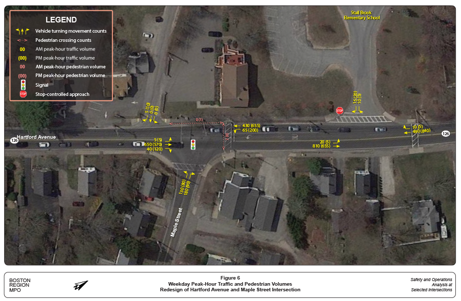
Figure 6 shows the peak-hour turning movement, pedestrian, and bicycle volumes in the study area. The peak hours were 7:00 AM–8:00 AM for the morning peak and 4:30 PM–5:30 PM for the evening peak. There were 19 total pedestrian crossing events observed during the seven-hour observation interval, although only three of those took place during the peak hours. Eight were counted at the beginning of the school day for Stall Brook School (8:30 AM) and five at the end of the school day (2:30 PM). No cyclists were observed.

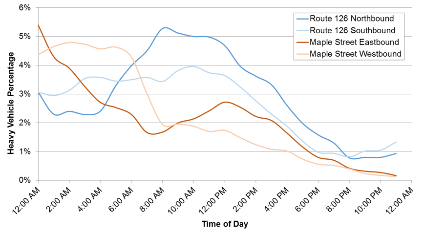
Because heavy vehicles were important to the project objective, MPO staff also investigated the patterns of heavy vehicle traffic through the study intersection. Figure 7 shows the hourly distribution of heavy vehicle traffic, based on ATR classification data. On Route 126, heavy vehicle traffic averages 4 percent of traffic and is highest during the morning peak period. On Maple Street, heavy vehicle traffic averages 3 percent of traffic and is highest overnight.
Figure 7
Hourly Heavy Vehicle Traffic
Heavy vehicles counted in the TMCs were also compared. Over the course of the seven-hour observation interval, 373 total heavy vehicles were recorded, although 80 percent of those passed north south through the intersection along Route 126 without performing a turning movement to access Maple Street. There were 23 heavy vehicles that entered Maple Street from Route 126 southbound and 11 that entered from Route 126 northbound. The pattern of heavy vehicles leaving Maple Street was almost symmetrical, with 23 turning onto Route 126 northbound and 14 turning onto Route 126 southbound.
The observed heavy vehicle volumes indicate that high numbers of trucks are not the primary issue, but rather safety and driver comfort. However, it is likely that more drivers will choose to use the intersection if it is changed to better accommodate their needs.
Twenty crashes were recorded by the Bellingham Police Department over the five-year period between 2011 and 2015. Table 1 breaks these crashes down by type of collision, severity, and factors that may have influenced the crash. It also compares the crash rate (crashes per million entering vehicles) with the District 3 average for signalized intersections. The crash rate calculations are in Appendix C.
Table 1
2011–15 Crash Summary and Crash Rates
Crash Variable |
Number of Crashes |
Crash Severity |
– |
Nonfatal injury |
3 |
Property damage only |
17 |
Manner of Collision |
– |
Angle |
2 |
Head-on |
1 |
Rear-end |
16 |
Sideswipe, opposite direction |
0 |
Sideswipe, same direction |
0 |
Single vehicle crash |
0 |
Unknown |
1 |
Road Surface Conditions |
– |
Dry |
12 |
Snow/ice |
1 |
Wet |
7 |
Ambient Light Conditions |
– |
Dark–lighted roadway |
5 |
Daylight |
14 |
Dusk |
1 |
Other |
0 |
Weather Conditions |
– |
Clear |
12 |
Cloudy |
2 |
Rain |
5 |
Snow |
1 |
Bicyclists and Pedestrians Involved |
– |
Bicyclist |
0 |
Pedestrian |
0 |
Time Period |
– |
Peak period |
14 |
Off-peak period |
6 |
Total Crashes |
20 |
Five-year average (rounded) |
4 |
Crash rate (calculated) |
0.61 |
Crash rate (MassDOT District 3) |
0.89 |
Some highlights of the data include:
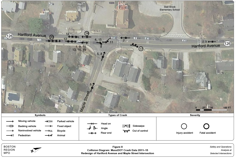
MPO staff also prepared a collision diagram for the study intersection to examine crash patterns. Police reports from the Bellingham Police Department were obtained for the years 2011–15. Figure 8 shows the collision diagram. The index numbers in the collision diagram may be used to cross-reference the crash records in Appendix C. The index numbers with circles around them refer to injury or fatal crashes, depending on the thickness of the circle line.
After analyzing the collision data, MPO staff concluded from the following information that safety was not the primary issue at the study intersection.
The design alternatives presented in this study will nonetheless seek to improve driver and pedestrian safety where possible by bringing the intersection up to MassDOT design standards.
Using the data and information collected, MPO staff built a traffic analysis network (with Synchro)8 for the AM and PM peak periods to assess the capacity and quality of traffic flow at the intersections. Staff conducted the analyses consistent with Highway Capacity Manual (HCM) methodologies.9 The HCM methodology demonstrates the driving conditions at signalized and unsignalized intersections in terms of levels of service (LOS) ratings A through F. LOS A represents the best operating conditions (little to no delay), while LOS F represents the worst operating conditions (very long delay). LOS E represents operating conditions at capacity (limit of acceptable delay). Table 2 shows the control delays associated with each LOS for signalized and unsignalized intersections.
Table 2
Levels of Service and Control Delays at Intersections
Level of Service |
Signalized Intersections Control Delay (seconds per vehicle) |
Unsignalized Intersections Control Delay (seconds per vehicle) |
A |
≤ 10 |
≤ 10 |
B |
> 10–20 |
> 10–15 |
C |
> 20–35 |
> 15–25 |
D |
> 35–55 |
> 25–35 |
E |
> 55–80 |
> 35–50 |
F |
> 80 |
> 50 |
Table 3
Levels of Service of Existing Conditions
Alternative/ Approach |
Move-ment |
AM LOS |
AM Delaya |
AM Queueb |
PM LOS |
PM Delay |
PM Queue |
Route 126 Northbound |
LTR |
C |
25.6 |
430 |
C |
31.2 |
#606 |
Route 126 Southbound |
L |
A |
6.0 |
20 |
B |
16.1 |
99 |
Route 126 Southbound |
TR |
A |
7.1 |
123 |
A |
8.2 |
238 |
Maple Street |
LTR |
E |
59.5 |
#349 |
D |
45.2 |
#191 |
Intersection Average |
All |
C |
26.4 |
– |
C |
22.1 |
– |
L = left turn. LOS = levels of service. R = right turn. T = straight through.
a Delay in seconds per vehicle.
b 95th percentile queue length in feet.
Notes:
# = the 95th percentile volume exceeds capacity.
Source: Central Transportation Planning Staff.
Table 3 presents peak-hour performance in terms of LOS, delay, and queues for existing conditions. The intersection operates near the top of LOS C conditions during both peak hours, which indicates satisfactory levels of delay. More detail on the analyses can be found in Appendix D.
MPO staff developed and analyzed three alternatives to address issues at the study intersection. Because the primary issue identified by the study was the inability of trucks to perform turning movements safely in the intersection, MPO staff designed each alternative with a modified intersection geometry that would accommodate all truck turning movements.
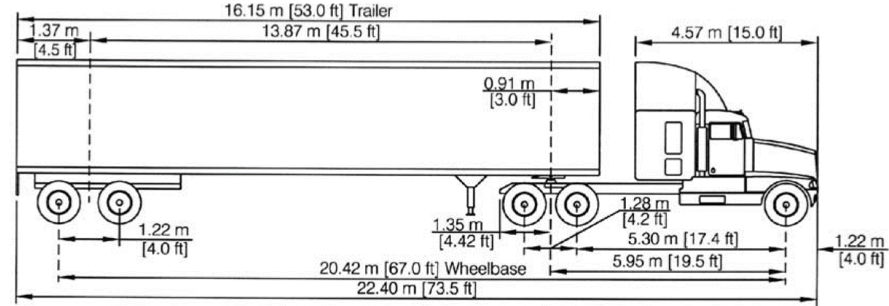
The required intersection dimensions and curb radii were calculated based on AutoTURN truck swept path simulations conducted by MassDOT for the purposes of this study.10 An interstate semitrailer WB-20 (also known as WB-65 or WB-67) was used as the design vehicle in those simulations (Figure 9).
Figure 9
Dimensions of WB-20 Design Vehicle
8 Trafficware Inc., Synchro Studio 9, Synchro plus SimTraffic, Build 914, Sugar Land, Texas.
9 Highway Capacity Manual, HCM 2010, Volume 3: Interrupted Flow, Transportation Research Board of the National Academies, Washington DC, December 2010.
10 Transoft Solutions, AutoTURN Swept Path Analysis Software, Version 10.2. Richmond, British Columbia.
MPO staff did not have direct access to the AutoTURN software so the proposals were based on a set of potential truck paths. Using an iterative approach where the simulation is run multiple times as different geometries are tested would yield more precise (and also more conservative, that is, less land taking) designs. This process can be undertaken later in the design phase.
As shown by the property lines in Figure 10, the right-of-way at the intersection extends only to the back of the sidewalk. Almost any effort to accommodate larger turning radii will therefore require either removing the sidewalk or expanding the right-of-way through land takings. Fortunately, the property at the north corner of Maple Street (2 Maple Street) is used as an auxiliary garage for the fire department and is already owned by the Town. The structures are more than 20 feet from the back of sidewalk, allowing a portion of this property to be used for expansion of the right-of-way. The property at the south corner of Maple Street (3 Maple Street) contains a private residence that is built very close to the existing back of sidewalk. However, the Town believes the property could be acquired and has expressed willingness to include this acquisition in design proposals.
Alternative 1, shown in Figure 10, accommodates truck-turning movements with a combination of wider curb radii and shifted stop lines. Route 126 and Maple Street are maintained on their original alignments.
Figure 11 and Figure 12 show how Alternative 1 accommodates the turning movements of a WB-20 semitrailer. Because the rear wheels of the truck lie so far behind the pivot point at the back of the cab (45.5 feet for a WB-20), the end of the trailer will tend to cut across the inside of any turn these trucks make. During right turns the rear wheels may ride up on the sidewalk and endanger pedestrians if the curb radius is too tight. In Alternative 1 the curb radius on the northern corner of Maple Street is increased to about 77 feet to accommodate trucks turning right from Maple Street onto Route 126 northbound, and the curb radius on the southern corner of Maple Street is increased to about 46 feet to accommodate trucks turning right from 126 northbound onto Maple Street. In both cases the curb would be moved back up to eight feet, and because the existing right-of-way extends only to the back of the sidewalk, roughly 830 ft² of land takings would be required to maintain the six-foot sidewalk present in these locations.
On the other hand, during left turns, the rear wheels of a truck drift into the middle of the roadway. This may bring them into conflict with vehicles waiting at the opposite approach and can endanger those drivers. To address this, the stop lines on the westbound and northbound approaches in Alternative 1 are moved away from the intersection to give the rear wheels on the truck enough space to return to the lane of travel. The stop line on Route 126 northbound is moved back about 35 feet to bring it out of the path of trucks turning left from Maple Street onto Route 126 southbound, and the stop line on Maple Street westbound is moved back about 25 feet to bring it out of the path of trucks turning left from Route 126 southbound onto Maple Street. Because there are no left turns onto Route 126 northbound, the stop line on the southbound approach is not in conflict and is kept in its original position.
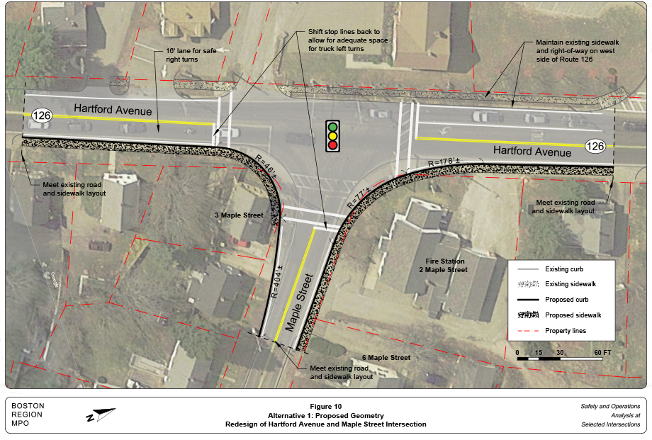
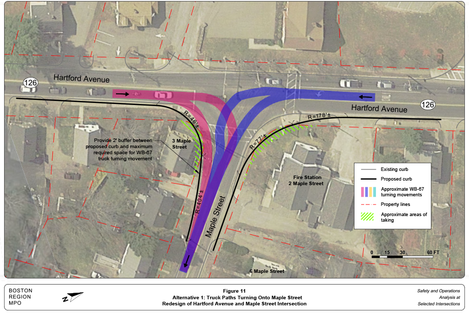

In addition to the geometric modifications already mentioned, Alternative 1 would include the following improvements:
MPO staff estimate the cost of Alternative 1 at between $1 million and $1.5 million. This includes design and construction but excludes potential right-of-way acquisition.
In Alternative 1, the stop lines must be shifted back a significant distance. This has the effect of making the intersection much larger and forces pedestrians to travel further out of their way to reach the crosswalk. Alternative 2, shown in Figure 13, aims to keep the stop lines closer to their original positions. To accomplish this, the Maple Street approach is widened slightly and the Route 126 alignment is shifted eight to 10 feet west. This helps create a more perpendicular approach from Maple Street to avoid forcing vehicles to make a difficult oblique angle turn as they are currently required to do. The degree to which Maple Street can be realigned is limited by the residential property to the east of the garage (6 Maple Street), which is only 100 feet from the intersection and extends to the back of the sidewalk. The stop line on the northbound approach must still be shifted back slightly for left turns from Maple Street and to accommodate the crosswalk. The trajectories of eastbound and westbound truck traffic can be seen in Figure 14 and Figure 15.
Another feature of Alternative 2 is that the driveway on the eastbound leg of the intersection is shifted 40 to 60 feet north and added to the intersection as a signalized approach. This helps to improve safety and reduce the confusion that results from having an unsignalized driveway entering almost directly into the intersection. Aligning this approach also provides some extra maneuvering room for turning heavy vehicles.
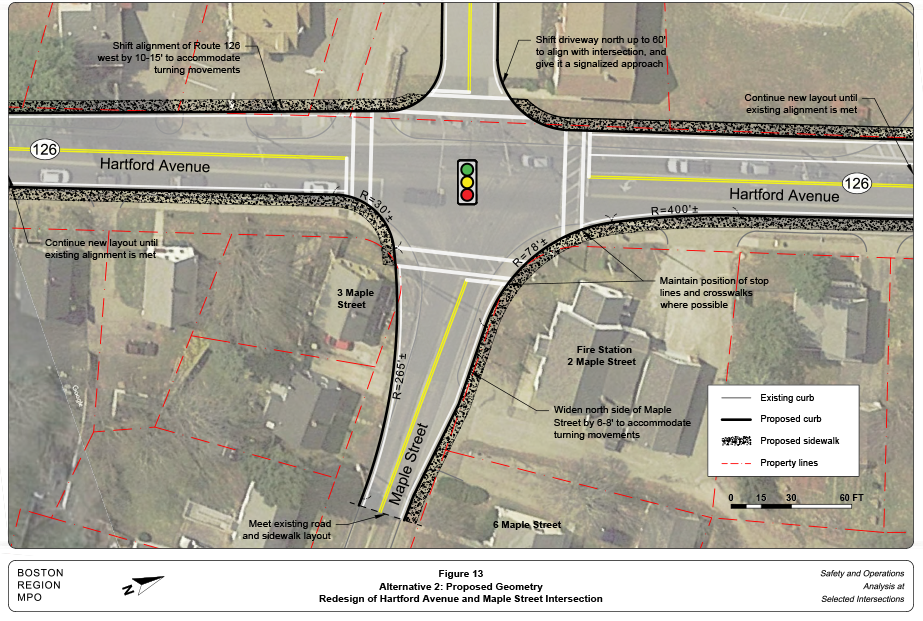
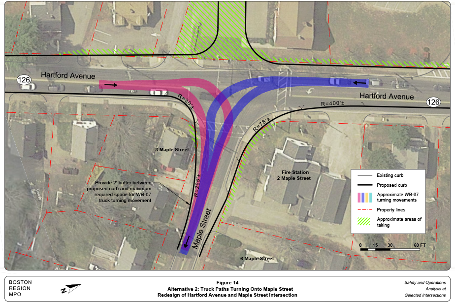
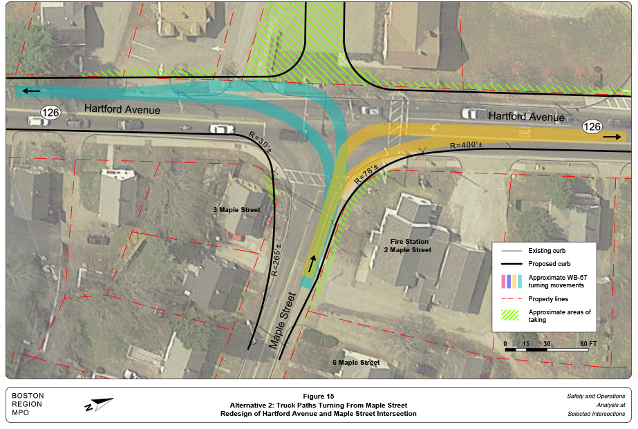
Alternative 2 requires more right-of-way acquisition than Alternative 1. However, because the building corner of 3 Maple Street is so close to the existing right-of-way, it would be expected that the property would have to be acquired as part of either alternative. If that is the case then it would make sense to use as much of that property as necessary.
As drawn, Alternative 2 also calls for some takings on the west side of Route 126, both to shift the alignment of Hartford Avenue west and to shift the eastbound driveway north. The Town believed that takings from this property (324 Hartford Avenue) might also be acquired at a reasonable price and wanted to consider it among the design options at the intersection. The amount of takings, if any, on that side of the intersection could be decided later during the design process.
Alternative 2 also includes the same pedestrian improvements and signal standardizations discussed in Alternative 1. MPO staff estimate the design and construction cost of Alternative 2 to be between $1.5 million and $2 million.
Alternative 3, shown in Figure 16, incorporates some of the suggestions from the Town of Bellingham into the original Alternative 2 design. Although the 2025 level of service is acceptable, the anticipated commercial and industrial growth on Maple Street has the potential to sustain traffic growth well beyond that threshold. Alternative 3 adds a right-turn bay from the Maple Street approach to increase the overall capacity of the intersection with the goal of extending the functional life of the design proposal. Like Alternative 2, this design also assumes that properties adjacent to Maple Street will have to be purchased and seeks to fully use this extra real estate. The estimated cost for Alternative 3 would be similar to the $1.5 million to $2 million range of Alternative 2.
Because it was added at a later stage in the project, MPO staff did not have the opportunity to test Alternative 3 with AutoTURN simulations. The geometry in Figure 16 gives a conceptual design only.
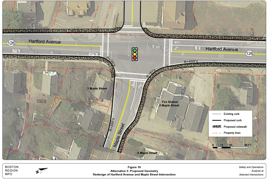
Table 4 summarizes the level of service analysis for the proposed alternatives. The 2025 future conditions project a uniform 5 percent traffic increase in the study area. More detail on the analyses can be found in Appendix D.
Table 4
Levels of Service of Proposed Alternatives
Alternative/ Approach |
Move-ment |
AM |
AM |
AM |
PM |
PM |
PM |
2025 No-Build |
– |
– |
– |
– |
– |
– |
– |
Route 126 Northbound |
LTR |
D |
38.4 |
#642 |
C |
34.5 |
#653 |
Route 126 Southbound |
L |
A |
9.5 |
29 |
C |
21.3 |
123 |
Route 126 Southbound |
TR |
A |
9.4 |
176 |
A |
8.4 |
259 |
Maple Street |
LT |
E |
55.4 |
#347 |
D |
49.5 |
#205 |
Maple Street |
R |
E |
55.4 |
#347 |
D |
49.5 |
#205 |
Intersection Average |
All |
C |
32.4 |
– |
C |
24.5 |
– |
Alternative 1 |
– |
– |
– |
– |
– |
– |
– |
Route 126 Northbound |
LTR |
D |
40.7 |
#648 |
D |
35.5 |
#659 |
Route 126 Southbound |
L |
A |
9.5 |
29 |
C |
20.1 |
118 |
Route 126 Southbound |
TR |
A |
9.4 |
176 |
A |
8.4 |
259 |
Maple Street |
LT |
E |
55.4 |
#347 |
D |
49.9 |
#205 |
Maple Street |
R |
E |
55.4 |
#347 |
D |
49.9 |
#205 |
Intersection Average |
All |
C |
33.4 |
– |
C |
24.8 |
– |
Alternative 2 |
– |
– |
– |
– |
– |
– |
– |
Route 126 Northbound |
LTR |
D |
53.9 |
#719 |
C |
33.2 |
#626 |
Route 126 Southbound |
L |
A |
9.1 |
34 |
A |
8.1 |
59 |
Route 126 Southbound |
TR |
B |
11.4 |
210 |
A |
8.8 |
261 |
Maple Street |
LT |
E |
56.7 |
#358 |
E |
56.4 |
#217 |
Maple Street |
R |
E |
56.7 |
#358 |
E |
56.4 |
#217 |
Driveway |
LTR |
C |
23.0 |
10 |
C |
30.2 |
21 |
Intersection Average |
All |
D |
40.4 |
– |
C |
23.3 |
– |
Alternative 3 |
– |
– |
– |
– |
– |
– |
– |
Route 126 Northbound |
LTR |
C |
26.3 |
511 |
B |
20.0 |
433 |
Route 126 Southbound |
L |
A |
5.2 |
23 |
A |
6.3 |
49 |
Route 126 Southbound |
TR |
A |
6.8 |
144 |
A |
6.2 |
219 |
Maple Street |
LT |
D |
42.7 |
#159 |
D |
40.3 |
99 |
Maple Street |
R |
D |
47.2 |
#222 |
D |
39.6 |
108 |
Driveway |
LTR |
C |
30.4 |
12 |
C |
32.1 |
22 |
Intersection Average |
All |
C |
23.8 |
– |
B |
15.2 |
– |
L = left turn. LOS = levels of service. R = right turn. T = straight through.
a Delay in seconds per vehicle.
b 95th percentile queue length in feet.
Notes:
# = the 95th percentile volume exceeds capacity.
Source: Central Transportation Planning Staff.
The proposed modifications are mostly geometric; only adding a turn lane in Alternative 3 and signalizing the driveway in Alternatives 2 and 3 significantly influenced level of service. Shifting stop lines back in Alternative 1 required an extra one-half second of all-red time on the northbound approach to clear the intersection, but this change had negligible effects on capacity.
The unsignalized intersection at the Stall Brook School driveway was also included in the analysis, although it did not have operational issues under any scenario. Those results can also be found in Appendix D.
The above analyses and evaluation supports the need for renovations that would improve access for heavy vehicles and enhance safety for pedestrians and motorists.
All of the proposed alternatives address the issue of truck maneuvers. The scale of the changes varies, however, with Alternative 1 providing the lowest cost option and Alternative 3 providing the most comprehensive solution.
Deciding between the three alternatives hinges upon:
If found to be suitable after considering the factors listed above, MPO staff recommends Alternative 3 because it represents the most complete solution to the issues encountered at the study intersection.
The Town of Bellingham has jurisdiction of the intersection and is responsible for renovations to improve safety, mobility, connectivity, and operations. This study gives the city an opportunity to review the needs of the intersection and plan for design and engineering. The next step would be to select the preferred alternative that is sensitive to the goals and needs of stakeholders, and then advance the project through the planning process. These steps will depend upon cooperation between MassDOT, the Town of Bellingham, and the MPO to begin the project notification and review process, and complete the project initiation form. After completing the initial steps, the Town of Bellingham and MassDOT can start preliminary design and engineering to place the project in the Transportation Improvement Program. Transportation decision making is complex, and influenced by factors such as financial limitations and agency programmatic commitments. Project development is the process that takes transportation improvements from concept to construction (see Appendix E for an overview of this process).
This study supports the MPO’s visions and goals, which include increasing transportation safety, maintaining the transportation system, advancing mobility and access, reducing congestion, and expanding the opportunities for walking and bicycling, while also making them safer. If implemented, the improvements proposed in this report would increase traffic safety and modernize the roadway to accommodate all users.