Route 138 Priority Corridor Study
Milton, Massachusetts
Project Manager
Seth Asante
Project Principal
Mark Abbott
Data Analysts
Benjamin Erban
Kathy Jacob
Chen Chen
Graphics
Kenneth Dumas
Kim DeLauri
Cover Design
Jane Gillis
The preparation of this document was supported
by Federal Highway Administration through
MPO 3CPL FFY18 Contract #1011725
MPO §5303 FFY18 Contract #102694
Central Transportation Planning Staff
Directed by the Boston Region Metropolitan
Planning Organization. The MPO is composed of
state and regional agencies and authorities, and
local governments.
Abstract
The Boston Region Metropolitan Planning Organization (MPO) selected Route 138 in the Town of Milton as the subject of a corridor study in federal fiscal year (FFY) 2018. The Route 138 Priority Corridor Study focuses on one of the locations identified in a regional needs assessment—conducted as part of the MPO’s Long-Range Transportation Plan, Charting Progress to 2040—used to guide investment decisions regarding transportation infrastructure improvements in the Boston region. The MPO prioritized this location for study after considering a number of factors: the need to address poor safety conditions and traffic congestion; the desire to enhance multimodal transportation; the need to maintain regional travel capacity; the interest in ensuring that, over time, corridor studies are funded in all subregions of the MPO’s planning area; and the potential for recommendations from the study to be implemented. This report details the analyses of the existing conditions and assessments of safety and operational problems in the corridor, discusses options for roadway improvements, and makes recommendations for implementing improvements.
Blue Hills Reservation Area (Southern Segment)
Brush Hill Area (Middle Segment)
Tucker Neighborhood (Northern Segment)
Chapter 2—Study Location, Goals, and Public Participation
2.2...... Study Vision and Goals
2.3...... Public Participation
Chapter 3—Characteristics of the Corridor
3.2...... Signalized Intersections
3.2.1 Route 138 and Brush Hill Road Intersection
3.2.2 Route 138 and Milton Street/Dollar Lane Intersection
3.2.3 Route 138 and Atherton Street/Bradlee Road Intersection
3.2.4 Route 138 and Robbins Street Intersection
3.2.5 Route 138 and Cheever Street/Blue Hill Terrace Street Intersection
3.2.6 Route 138 and Brook Road Intersection
3.3 ..... Unsignalized Intersections
3.3.1 Route 138 and Neponset Valley Parkway Intersection
3.3.2 Route 138 and Blue Jay Way Intersection
3.3.3 Route 138 and Aberdeen Road Intersection
3.3.4 Route 138 and Oak Street Intersection
3.5...... Planned Projects and Studies
3.5.1 Roadway Improvements on Route 138 in Canton and Milton
3.5.2 Road Safety Audit, Route 138 at Atherton Street/Bradlee Road and Milton Street/Dollar Lane
4.2...... Daily Traffic Volumes
4.3...... Turning Movement Volumes
4.4...... Pedestrian and Bicycle Volumes
4.5...... Pedestrian Level of Service
4.7...... Signal Timing and Layout Information
Chapter 5—Existing Conditions Analyses
5.1.2 HSM Methodology: Expected Crashes
5.2...... Traffic Operations Analysis
5.2.1 Intersection Level-of-Service Analysis
5.2.2 Traffic Signal Warrant Analysis
Chapter 6—Community Engagement
6.2...... Milton Wikimap Feedback
Chapter 7—Improvement Concepts
7.1...... Route 138 Segment in the Blue Hills Reservation Area
7.2.1 Alternative 1: Three-Lane Cross-Section with a Multi-Use Path on the East Side of the Roadway
7.2.2 Alternative 2: Two-Lane Cross-Section with Dual Bicycle Lanes and Sidewalks
7.2.2 Redesign of the Canton Avenue and Blue Hill Avenue Intersection
7.3...... Route 138 Segment in the Brush Hill Area
7.3.1 Alternative 1: Two-Lane Cross-Section with a Multi-Use Path on the East Side of the Roadway
7.3.2 Alternative 2: Two-Lane Cross-Section with Dual Bicycle Lanes and Sidewalks
7.3.3 Additional Improvements at Selected Intersections
7.4...... Route 138 Segment in the Tucker Neighborhood
7.4.2 Alternative 2: Two-Lane Cross-Section with Dual Bicycle Lanes and Sidewalks
7.4.3 Additional Improvements at Selected Intersections
Chapter 8—Performance of Future Conditions
8.1...... Intersection Level-of-Service (LOS) Performance
8.2...... Pedestrian Level-of-Service Performance with Improvements
8.3...... Safety Impacts of Proposed Improvemetns
Chapter 9—Conclusion and Next Steps
9.1...... Time Frame and Costs for the Improvements
9.2...... Benefits of the Study
9.3...... Project Implementation
Table 1 Pedestrian Crossing by Type
Table 2 Potential for Safety Improvement
Table 3 Comprehensive Costs of Crashes
Table 4 Intersection Level-of-Service Criteria
Table 5 Summary of Signal Warrant Analysis
Table 6 Route 138 at Brush Hill Road
Table 7 Route 138 at Neponset Valley Parkway
Table 8 Route 138 at Milton Street/Dollar Lane Intersection
Table 9 Route 138 at Atherton Street/Bradlee Road Intersection
Table 10 Route 138 at Robbins Street
Table 111 Route 138 at Cheever Street/Blue Hill Terrace Street
Table 12 Route 138 at Aberdeen Road and Oak Street
Table 13 Route 138 at Brook Road
Figure 1. Regional Map of Study Area and Nearby Roadways
Figure 2. Jurisdiction of Roadways in the Route 138 Study Area
Figure 3. Width of Right of Way and Shoulders on Route 138 in Milton
Figure 4. Locations of Existing Sidewalks on Route 138 in Milton
Figure 5. Study Intersections on Route 138 in Milton
Figure 6. Land Use and Zoning Map along Route 138 in Milton
Figure 7. Weekday and Weekend Average Traffic Volumes on Route 138 in Milton
Figure 8. Weekday and Weekend Hourly Traffic-Volume Distribution on Route 138 in Milton
Figure 9. Turning Movement Volumes on Route 138 in Milton Weekday AM and PM Peak Hour
Figure 10. Turning Movement Volumes on Route 138 in Milton Weekend AM and PM Peak Hour
Figure 11. Peak Period Pedestrian Volumes
Figure 12. Peak Period Bicycle Volumes
Figure 13. Observed Spot Speeds and Posted Speed Limits on Route 138 in Milton
Figure 14. Crashes by Intersection and Segment (2011 - 2015)
Figure 15. Observed and Expected Crashes by Intersection and Segment
Figure 16. Existing Conditions Weekday AM Peak Hour Intersection Level of Service
Figure 17. Existing Conditions Weekday PM Peak Hour Intersection Level of Service
Figure 18. Existing Conditions Weekend PM Peak Hour Intersection Level of Service
Figure 19. Survey Questions and Number of Respondents
Figure 30. Improvement Concept: Alternative 2 - Dual Bicycle Lanes and Sidewalks: Brush Hill Road
Figure 35. Improvement Concept: Alternative 2 - Dual Bicycle Lanes and Sidewalks: Robbins Street
Figure 41. Improvement Concept: Alternative 2 - Dual Bicycle Lanes and Sidewalks: Brook Road
Figure 42. Future Conditions: Weekday AM Peak Hour Intersection Level of Service
Figure 43. Future Conditions: Weekday PM Peak Hour Intersection Level of Service
Figure 44. Future Conditions: Weekend PM Peak Hour Intersection Level of Service
The Boston Region Metropolitan Planning Organization (MPO) selected Route 138 in the Town of Milton as the subject of a corridor study in federal fiscal year (FFY) 2018. The Route 138 Priority Corridor Study focuses on one of the locations identified in a regional needs assessment—conducted as part of the MPO’s Long-Range Transportation Plan (LRTP), Charting Progress to 2040—used to guide investment decisions regarding transportation infrastructure improvements in the Boston region.
The MPO prioritized this location for study after considering a number of factors, including the need to address poor safety conditions and traffic congestion; desire to enhance multimodal transportation; need to maintain regional travel capacity; and the potential to implement the study recommendations. The report analyzes the existing conditions, assesses safety and operational problems in the corridor, and discusses concepts for roadway improvements.
Route 138 in Milton is a two-way, two-lane principal arterial under the jurisdiction of the Massachusetts Department of Transportation (MassDOT). The Town of Milton has jurisdiction of the majority of the crossing streets. The Department of Conservation and Recreation (DCR) has jurisdiction of Green Street and Neponset Valley Parkway; DCR also oversees the Blue Hills Recreational area.
The MassDOT Highway Division, Town of Milton, and Boston Region MPO collected and assembled the data used to assess the existing conditions and identify problems in the corridor, which included vehicular, pedestrian, and bicycle volumes, traffic speeds, crashes, zoning and land uses, and community input data (community survey).
Our analysis rates the corridor as poor based on the quality of vehicular, pedestrian, and bicycle travel it provides. Many locations in the study area experienced a greater-than-expected number of crashes; and two intersections are on the list of Highway Safety Improvement Program (HSIP) crash clusters.1 The roadway is considered unfriendly for pedestrians and bicyclists because of
The traffic safety and operational problems facing roadway users include, but are not limited to
MPO staff, working with an advisory task force (representatives from MassDOT and Town of Milton), developed Complete Streets concepts for the corridor. Presently, MassDOT project #608484: Canton-Milton Roadway Improvements on Route 138, which had already been programmed in the 2020 Transportation Improvement Program (TIP), addresses roadway and related work on Route 138 in Canton and Milton. For the purposes of this study, staff divided the corridor into three segments—southern, middle, and northern—and developed improvement concepts for each segment.
Both Alternatives 1 and 2 provide a pedestrian- and bicyclist-friendly environment. However, Alternative 1 avoids relocating utility poles on the west side of the roadway, which could impact the project schedule because of right-of-way concerns. Alternative 1 also fits the character of the neighborhood and would encourage more people to bicycle and walk. Alternative 2 has better connectivity and reduces pedestrian and bicycle crossings.
Additional improvement concepts that could be incorporated into either alternative include:
In this segment, both Alternatives 1 and 2 provide a pedestrian- and bicyclist-friendly environment. However, Alternative 1 addresses parking needs of the residents and Alternative 2 does not.
The concepts developed in this study provide the Town of Milton, MassDOT, and other stakeholders an opportunity to review, at a conceptual level, options for addressing the deficiencies in the corridor, before committing design and engineering funds to a roadway improvement project. If implemented, the proposed improvements offered in this report would increase traffic safety, make traffic operations more efficient, and modernize the roadway to accommodate all users. MassDOT, DCR, and the Town of Milton are not obligated to make these improvements, but if they were to seek improvements on this roadway, this document would be a good guide.
Chapter 7 describes in detail short-, medium-, and long-term improvements, as well as cost estimates for each improvement, categorized as low (less than $10,000), medium ($10,000 to $500,000), and high ($500,000 or more). The short-term improvements, usually low cost, are relatively uncomplicated and inexpensive to implement, and require minimal design efforts. They include installing signs; pavement markings; in-pavement detection for bicyclists; countdown timers for pedestrians; high-visibility crosswalks; traffic signal retiming; and upgrades to signal-head backplates.
The medium-term improvements, usually low-to-medium cost, are more complicated than their short-term counterparts and require more funding resources and design and engineering efforts. Medium-term improvements include installing pedestrian-activated midblock crosswalks; reconfiguring existing roadway shoulders into bicycle lanes; improving drainage; upgrading signal equipment to include an Opticom system for emergency preemption; reconstructing substandard sidewalks; modifying geometry; and managing driveway access.
The long-term improvements, usually high-cost, typically require more design and engineering efforts, environmental permitting, and more funding resources. They include improving street lights; installing new sidewalks; reconstructing intersections to improve safety; managing capacity and mobility; and installing new traffic signals.
This study aligns with the Boston Region MPO’s goals of modernizing roadways to improve capacity and mobility by expanding the quantity and quality of walking and bicycling infrastructure; making transit service more efficient; reducing congestion; increasing safety on the region’s highway system; and preserving the transportation system.
The Boston Region Metropolitan Planning Organization (MPO) has been conducting studies of roadway corridors identified through the Needs Assessment of the Long-Range Transportation Plan (LRTP) as needing infrastructure improvements to address safety, mobility, and traffic operations problems. Municipalities in the region have been receptive to these studies, which provide them with the opportunity to review, at a conceptual level, what is required to improve a specific arterial segment before committing design and engineering funds to a project. After reviewing their options, if a city or town initiates a project that qualifies for state and federal funds, the study’s documentation may be useful to both MassDOT and the project proponent. The information provided in the study’s report is useful for completing MassDOT Highway Division’s project initiation forms, identifying problems along the corridor, justifying the need for improvements, allocating funding, and providing improvement concepts to advance into the preliminary design and engineering stages.
MPO staff identified a number of arterial roadway segments that should be prioritized because they require maintenance, modernization, and safety and mobility improvements; these roadway segments are listed in the LRTP. To address the problems that exist in some of these arterial segments, a study was included in the federal fiscal year (FFY) 2018 Unified Planning Work Program (UPWP). Through this study, MPO staff recommended conceptual improvements for one or more corridors, or several small sections within a corridor. MPO staff selects locations for study—considering municipal, Subregional, and other public feedback—and collect data, conduct technical analysis, and recommend improvements. Recommendations from the study are sent to implementing agencies, which may choose to fund improvements through various federal, state, and local sources, separately or in combination. By focusing on arterial segments rather than intersections, planners can evaluate multimodal transportation needs comprehensively with the goal of creating Complete Streets.
Chapter 2—Study Location, Goals, and Public Participation
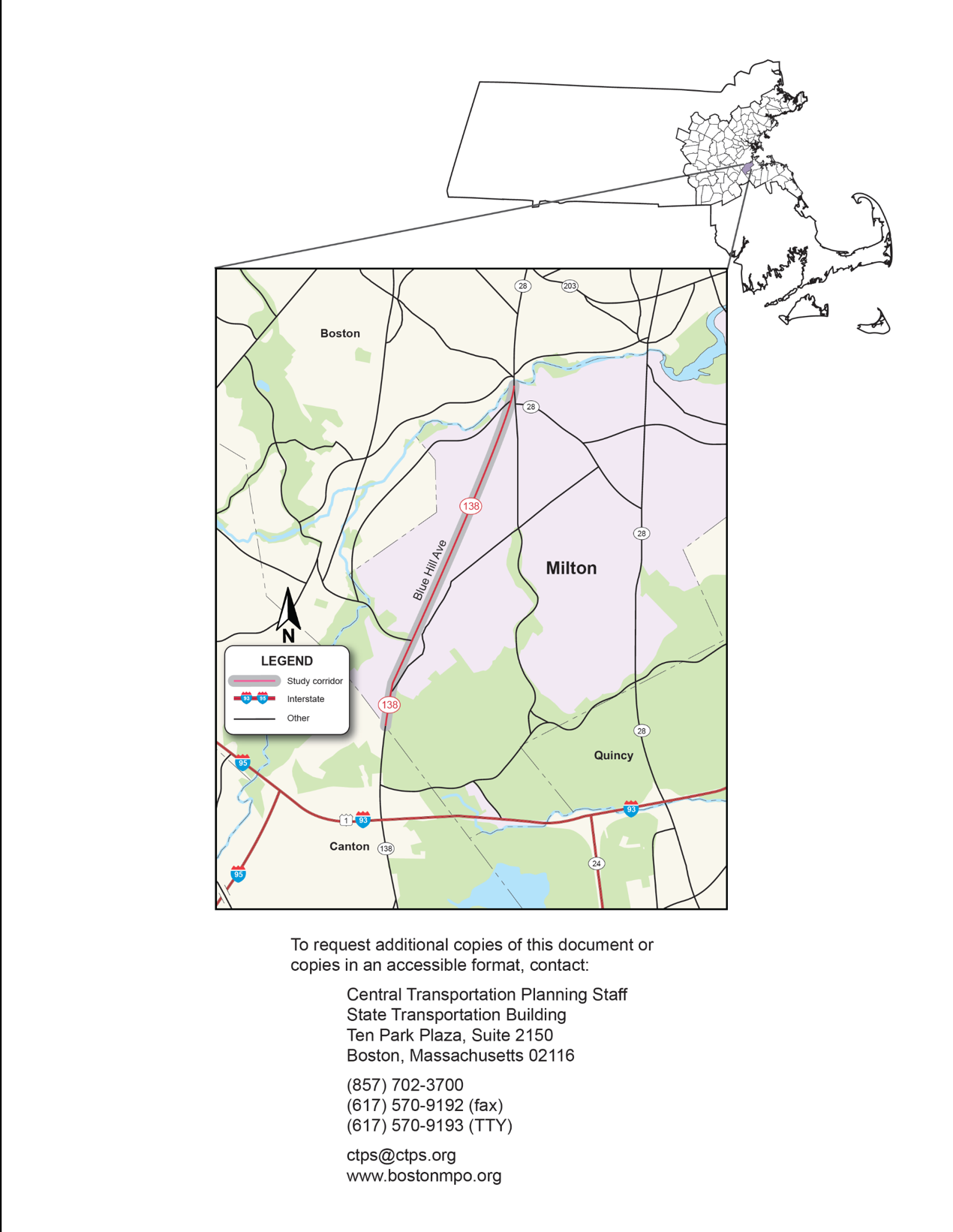
On January 18, 2018, the Boston Region MPO gave approval to its staff to study Route 138 in Milton, following a selection process that involved a review of safety conditions, congestion, multimodal and regional significance of the roadway, regional equity, and the potential for implementing study recommendations.4, 5, 6, 7, 8, 9 The map in Figure 1 shows the arterial roadway segments in the study area. (All figures are included at the end of the report.)
The study location was selected from a list of 44 arterial segments in 33 municipalities in the MPO region.10 A copy of the technical memorandum describing the selection process is included in Appendix A. MassDOT Highway Division District 6, the MassDOT Office of Transportation Planning, and the Town of Milton supported the study of Route 138. They participated by collecting data needed for the analyses, reviewing documentation of existing conditions, identifying problems, and developing improvements to mitigate the problems.
The Town of Milton and MassDOT have shown a commitment to supporting alternative transportation options through the Healthy Transportation Compact. Transforming Route 138 into a Complete Streets format that balances the needs of motorists with the needs of pedestrians and bicyclists by increasing the quantity and quality of infrastructure for walking, biking, and bus transit would make the road more efficient by 11
Toward that end, the objectives of this study were to
An advisory task force—composed of representatives from the Town of Milton and MassDOT—was established to guide this study. MPO staff met with the task force twice. In the first meeting they discussed the work scope and existing problems. In the second meeting, MPO staff presented the existing conditions, analyses, proposed improvements, and received advice from the task force members. This report reflects the task force’s feedback. Appendix A includes a list of task force members and comments.
Chapter 3—Characteristics of the Corridor
Route 138 is a state highway in Massachusetts that runs from Milton south to Fall River. This roadway serves regional and local traffic traveling to Boston to the north and Canton, Stoughton, and Easton to the south. Figure 2 shows the roadway jurisdiction, which identifies the authority and obligation of agencies to administer, control, construct, maintain, and operate a highway subject to the provisions of the Commonwealth of Massachusetts. It is a two-lane, two-way roadway classified as a principal arterial, state designated truck route, and part of the National Highway System (NHS) program.
Figure 3 shows the right-of-way and shoulder widths along roadway. In Milton, the roadway’s right-of-way width varies between 50 and 65 feet and it has six feet or more paved shoulder on either side for the majority of the corridor.12 Figure 4 shows the sidewalk network on Route 138. Approximately, 70 percent of the corridor either lacks sidewalks or has sidewalks that do not meet MassDOT’s standards; thus, a significant portion of the roadway could be retrofitted to include sidewalks and the existing substandard sidewalks could be reconstructed.13
Providing facilities to keep pedestrians and bicyclists separated from vehicular traffic in this corridor is a high priority because of the high volumes of traffic, high vehicle speeds, high volumes of truck traffic, and mixed land uses (residential, educational, and recreational). The utility poles in the corridor are mostly located on the west side of the roadway and many of the properties along the corridor have stone walls marking the boundaries.
Several cross streets and driveways intersect Route 138, which create safety and operations problems not only for motorists but to also for pedestrians and bicyclists. Figure 5, shows the intersections selected for study. There are six signalized intersections in corridor:
All of the traffic signals are equipped with fully actuated traffic-control systems; however, they are very old and lack Opticom systems for emergency preemption. The equipment, along with the existing signal timings and phasing plans, needs to be upgraded. The traffic-signal heads are mounted on mixture of mast-arm and post mounts and they lack backplates. Over-grown vegetation and tree branches obscure some of the signal heads, especially in spring and summer. There are no pedestrian facilities such as sidewalks, crosswalks, and push-button pedestrian-activated signals at two signalized intersections: Brush Hill Road and Milton Street/Dollar Street. MassDOT has jurisdiction over the signalized intersections and is responsible for implementing improvements to the intersections.
Brush Hill Road is a town-owned collector street that intersects Route 138 at an oblique angle to form a four-leg signalized intersection. It is one of the critical intersections in the corridor as there are high traffic volumes on both Route 138 and Brush Hill Road during peak periods. Route 138 has one lane on each approach and Brush Hill Road has two lanes on the westbound approach (an exclusive left-turn lane and a through- right-turn lane) and one travel lane on the eastbound approach. Northbound left turns are prohibited at the intersection; northbound drivers are required to proceed to Brush Hill Road via Canton Avenue. The Thacher Montessori School is in the southwestern corner of the intersection.
Milton Street and Dollar Lane are town-owned collector roads that intersect Route 138 to form a four-leg signalized intersection. Each of the approaches at the intersection has one travel lane. The intersection curb radii are adequate for trucks and buses. The land uses adjacent to the intersection are primarily residential.
Atherton Street and Bradlee Road are town-owned collector roads. They intersect with Route 138 at an oblique angle to form a four-leg signalized intersection. Route 138, Atherton Street, and Bradlee Road have one lane on each approach. There are sidewalks only on the north side of Atherton Street/Bradlee Road and crosswalks with curb ramps and detectable warning plates and pedestrian signals are present at the intersection. The intersection curb radii are adequate for trucks and buses servicing business activities; however, trucks are prohibited on Atherton Street and Bradlee Road. The land uses in the area are residential, and the Milton Fire Department, which experiences cut-through traffic, is located at the intersection.
Robbins Street is a town-owned local roadway; it intersects Route 138 at an oblique angle to form a four-leg signalized intersection. Each approach at the intersection has one lane serving all traffic movements. South of the intersection, there is a sidewalk on the west side of Route 138, which continues on the east side of Route 138, north of the intersection. A crosswalk connects both sidewalks diagonally across Route 138, and the curb ramps are constructed to MassDOT standards. On Robbins Street, the sidewalks are on north side of the roadway east of the intersection, and on the south side west of the roadway. There are functioning push-button pedestrian signals for crossing Route 138. Sight distance at the intersection is poor because Robbins Street intersects Route 138 at an oblique angle and has a slope. The intersection curb radii are adequate for trucks and buses; and the land uses in the area are mostly residential.
Cheever Street and Blue Hill Terrace Street are town-owned, local streets that intersect Route 138 at an oblique angle to form two closely spaced three-leg signalized intersections. The offset between the two intersections is about 100 feet long. Each approach at the intersection has one lane serving all traffic movements. There are sidewalks on either side of the roadways and crosswalks with curb ramps, but the curb ramps lack warning plates. The intersection curb radii are not adequate for trucks and buses. The land use near the intersection is residential.
Brook Road is a town-owned local roadway; it intersects Route 138 at an oblique angle to form a four-leg signalized intersection. The west segment of Brook Road is a two-way, two-lane roadway, and the east segment is a one-way, one lane roadway, that moves traffic away from the intersection (eastbound only). Each approach at the intersection has one lane serving all traffic movements. There are sidewalks along either sides of both roadways, and crosswalks have been installed on all four approaches. The crosswalks have curb ramps but they lack detection-warning plates. Sight distance at the intersection is poor because Brook Road intersects Route 138 at an oblique angle. The intersection curb radii are adequate for trucks and buses. The land use in the area is mostly residential.
All of the selected unsignalized intersections are two-way stop-controlled intersections with one travel lane on each approach. Route 138 is the major street at the all of the intersections and its traffic is not controlled. The minor streets have stop signs. The intersection curb radii are adequate for trucks and buses and the land uses surrounding the intersections are primarily residential.
Neponset Valley Parkway is a principal arterial roadway under the jurisdiction of the Department of Conservation and Recreation (DCR). It intersects Route 138 to form a three-leg unsignalized intersection. A high volume of left-turns off of Route 138 and right turns off of Neponset Valley Parkway occur at the intersection during peak travel periods. There are no pedestrian facilities at the intersection, except for a sidewalk on the north side of Neponset Valley Parkway that terminates at the intersection.
Blue Jay Way is a privately owned local street—the main entrance to Curry College. It intersects Route 138 to form a T-type unsignalized intersection, under the jurisdiction of MassDOT. There is no pedestrian facility at the intersection. The intersection curb radii are adequate for trucks and buses that serve businesses and institutions in the area.
Aberdeen Road is a town-owned roadway that intersects Route 138 to form a T-type unsignalized intersection. Aberdeen Road is stop controlled. There are sidewalks on either side of Route 138 and Aberdeen Road. In addition, there are crosswalks with curb ramps at the intersection; the crosswalk across Route 138 has pedestrian signals with pedestrian-activated pushbuttons. The intersection curb radii are adequate for trucks and buses. The Concord Baptist Church is located on the east side of Route 138 across from Aberdeen Road.
Oak Street is a town-owned roadway that intersects Route 138 to form a four-leg unsignalized intersection. The north and south legs of Oak Street are offset about 40 feet apart. There are sidewalks along either side of Route 138 and Oak Street; and crosswalks have been installed on both roadways; however, the curb ramps lack detection warning plates. Many of the Tucker Elementary School students cross Route 138 at Oak Street, and a school crossing guard is posted at the intersection during school openings and closings. The Tucker Elementary School is located on the east side of Route 138 on Oak Street.
The map in Figure 6 shows the general land-use designations for the area surrounding Route 138. The area is generally zoned residential except for the park and open space of the Blue Hills Reservation. The southern and middle portions of the area surrounding the corridor is lightly settled with one-family detached dwellings, and the northern portion is densely settled with one-family dwellings.
Other land uses in the area include
Transportation projects planned for the Route 138 corridor and previous studies that addressed the study area or its surroundings are described below. The conceptual improvements developed in this study considered and incorporated recommendations from the previous studies.
MassDOT’s project number 608484 will resurface and make Complete Streets improvements on Route 138 in Canton and Milton. Funding for the project is planned to be programmed in the Boston Region MPO’s federal fiscal year (FFY) 2020 Transportation Improvement Program (TIP). As of August, 2018, the project was in the preliminary design stage.14 Some of the recommendations in this study would be incorporated and implemented as part of that project.
In 2015, the Town of Milton, in collaboration with MassDOT, conducted a road safety audit (RSA) for two intersections of Route 138 at Atherton Street/Bradlee Road and Milton Street/Dollar Lane.15 The RSA was conducted because the intersection was identified as a high-crash location based on the 2012 Highway Safety Improvement Program (HSIP) crash cluster data.16 The MassDOT Highway Division’s Traffic and Safety Engineering 25% Design Submission Guidelines require an RSA for all project-related high-crash locations to identify safety enhancements that may be implemented in conjunction with an off-site mitigation project, and other measures that could be programmed for implementation by other agencies or municipalities. The RSA recommended several short-, medium-, and long-term improvements to address safety and operations problems at the intersections. They included provisions for left-turn lanes on Route 138, modifying the signal phasing and timing plans, upgrading signal equipment, geometric enhancements, pavement markings, and new signage.
MassDOT Highway Division’s Traffic Data Collection section conducted automatic traffic recorder (ATR) counts during a six-day period from Tuesday, March 27, 2018 to Sunday, April 1, 2018. The ATR machines count vehicles continuously during the collection period and are used to determine the volume of traffic on a roadway. MassDOT planned counts at 21 sites initially, although equipment issues at five sites (mostly in the northern third of the corridor) prevented data collection at those sites.
MassDOT Highway Division's Traffic Data Collection Section also collected turning-movement counts (TMCs) in the study area on Thursday, March 29, 2018. MassDOT performed TMCs at 17 locations on the Route 138 corridor, conducting the counts during the weekday AM peak travel period (6:00 AM to 9:00 AM) and weekday PM peak travel period (3:00 PM to 6:00 PM). MassDOT performed a second count on Saturday, March 31 at seven of those locations, and at an additional eighth location on a Sunday (in order to capture volumes of churchgoers near the Concord Baptist Church). In all cases, MassDOT recorded heavy vehicles, pedestrians, and bicycles separately.
Figure 7 shows a summary of the Average Daily Traffic (ADT) data recorded using the MassDOT counts. Figure 8 shows the amount of daily traffic variation at four locations along Route 138. The counts on Route 138 show that traffic gradually diminishes toward the north end of the corridor as drivers turn off of Route 138 to access various Boston destinations; this occurs mainly on side streets at Canton Avenue, Brush Hill Road, Neponset Valley Parkway, and Milton Street. Notably, the counts indicate that there is little difference between weekday and weekend volumes, based, in part, on the recreational attractions present in the corridor. Appendix B contains full records of the ATR counts.
Figure 9 shows the turning movement volumes at the major intersections during the weekday AM and PM peak hours. Peak hours in the corridor were recorded as 7:30 AM to 8:30 AM in the morning and 3:00 PM to 4:00 PM in the afternoon peak. The afternoon volumes were remarkably consistent and stayed within four percent of the highest peak volumes throughout the entire afternoon collection period. This kind of “peak spreading” is a common characteristic of urban roadways where demand exceeds available capacity.
Figure 10 shows the turning movement volumes at the eight intersections where an additional weekend count was requested. As with the weekday counts, the weekend counts were conducted during a morning period (8:00 AM–11:00 AM) and an evening period (2:00 PM–5:00 PM). The highest volumes were observed between 3:00 PM and 4:00 PM hour, during which time the total intersection volumes were five percent higher than during the weekday PM peak hour, and only two percent lower than during the weekday AM peak hour. Appendix B contains the turning movement data.
The TMC data were also used to provide staff with information about pedestrian and bicyclist activity during the three-hour collection periods. Figure 11 cites the observed pedestrian volumes; and Figure 12 cites the observed bicyclist volumes. Table 1 also distinguishes the number of pedestrians that crossed Route 138 from those that crossed an adjacent side street.
Table 1
Pedestrian Crossing by Type
Count Period |
Weekday |
Weekend |
||||
Crossing Location |
Route 138 |
Side Streets |
Total |
Route 138 |
Side Streets |
Total |
South Parking Lot Entrance |
0 |
0 |
0 |
21 |
9 |
30 |
South Parking Lot Exit |
0 |
1 |
1 |
2 |
6 |
8 |
North Parking Lot Entrance |
0 |
0 |
0 |
0 |
3 |
3 |
Green Street |
0 |
12 |
12 |
5 |
46 |
51 |
Canton Avenue |
0 |
1 |
1 |
0 |
17 |
17 |
Thacher Montessori School |
0 |
2 |
2 |
0 |
1 |
1 |
Brush Hill Road |
0 |
1 |
1 |
1 |
1 |
2 |
Neponset Valley Parkway |
0 |
2 |
2 |
1 |
2 |
3 |
Milton Street / Dollar Lane |
1 |
2 |
3 |
7 |
2 |
9 |
Blue Jay Way |
3 |
19 |
22 |
-- |
-- |
-- |
Atherton Street / Bradlee Road |
1 |
6 |
7 |
-- |
-- |
-- |
Robbins Street |
2 |
7 |
9 |
-- |
-- |
-- |
Cheever Street / Blue Hill Terrace |
13 |
29 |
42 |
-- |
-- |
-- |
Aberdeen Road |
19 |
51 |
70 |
94 |
143 |
237 |
Oak Street |
102 |
166 |
268 |
-- |
-- |
-- |
Brook Road |
22 |
46 |
68 |
-- |
-- |
-- |
Source: Central Transportation Planning Staff.
The counts show that pedestrian activity is highest in the north section of the corridor where there are dense residential neighborhoods, an elementary school, and a church. The rest of the corridor does not see a lot of pedestrian traffic, although pedestrian traffic increased on Saturday near the Blue Hills Reservation. Bicycle counts were similarly low except near Blue Hills on the weekend. MPO staff attributes the low pedestrian and cyclist volumes primarily to the absence of appropriate facilities in the corridor. Other contributing factors might include cold April weather, high vehicle speeds, and high traffic volumes during peak periods. Bicycle volumes in particular were found to be at their lowest during peak commuting hours.
The quality of pedestrian travel is largely affected by the roadway infrastructure, such as whether there are sidewalks or traffic signals that allow pedestrians time to cross an intersection before vehicles get a green light. To reflect the complex relationship between pedestrians and their travel environments, MPO staff developed a Pedestrian Report Card Assessment tool, which grades a given roadway on its quality of pedestrian travel; and whether it reflects the MPO’s goals for safe pedestrian facilities, expands pedestrian infrastructure, improves connectivity of the transportation network, and enhances economic vitality in the region.17 The ratings in this pedestrian assessment tool (displayed in Appendix F) correlate with the goals emphasized in the MPO’s Long-Range Transportation Plan (LRTP): safety, system preservation, capacity management and mobility, and economic vitality. Based on the tool, Route 138 in Milton was rated good in terms of safety (although vehicle speeds remain an issue), fair in terms of system preservation, and poor in terms of economic vitality and capacity management and mobility. Overall, the assessment indicates that the roadway needs improvements to accommodate pedestrians.
Staff collected vehicle travel speeds and volumes at four of the ATR sites on Route 138. Figure 13 summarizes the speed data and compares it with the posted speed regulations present in the study area. MassDOT data show that several locations had 85th-percentile speeds well above the posted limit. In particular, there were two locations on Route 138 southbound where 85th-percentile speeds of 51 mph and 43 mph were observed in zones with a 35 mph speed limit. Appendix B contains more information on about speed data.
MassDOT provided MPO staff with existing signal timings, as-built traffic signal plans, and signal-phase sequences of the signalized intersections (included in Appendix C). MPO staff used Google Maps and field visits to identify recent modifications to the intersection layouts and signal plans in order to analyze the condition of existing traffic operations.
The Massachusetts Bay Transportation Authority (MBTA) bus Route 716—Cobbs Corner to Mattapan Station—operates throughout the length of the Route 138 corridor in Milton. It provides bus service to Cobbs Corner in Canton, Canton Center Station on the MBTA’s Providence/Stoughton commuter rail line, Royall Street and the nearby business park, Curry College, and the Mattapan Red Line station. Buses run Monday through Friday every 90 minutes from 5:50 AM to 7:20 PM, and hourly on Saturdays from 8:00 AM to 5:55 PM. There is no service on Sundays. Appendix D contains the Route 716 schedule and a map showing the 14 stops in Milton.
A&A Metro Transportation, under contract with the MBTA, operates this bus service. The 716 line has a flexible-stop policy, which allows riders to signal the driver if they wish to board or alight at a location other than a designated stop. However, poor lighting along the corridor can make it difficult for drivers to see those users. The Route 138 corridor also is accessed easily via the red line Mattapan Station, which is just one-quarter mile north of the corridor and is also the terminus of the 716 bus line. From Mattapan, riders can use the Mattapan Trolley and transfer at Ashmont Station for service to downtown Boston.
Chapter 5—Existing Conditions Analyses
To evaluate safety for motorists, pedestrians, and bicyclists in the study area, MPO staff used crash data from MassDOT’s Registry of Motor Vehicles database and from the Milton Police Department from January 2011 through December 2015. The following sections describe the analyses and results of this safety assessment.
Two hundred sixty-two (262) crashes were recorded in the MassDOT database during the five-year analysis period. Figure 14 shows the spatial distribution of these crashes within the study area.
Some features of the dataset include
Appendix E contains figures and tables that break down the crash data.
MPO staff used methods from the 2010 edition of the Highway Safety Manual (HSM) to analyze safety. The techniques in the HSM combine roadway geometry, traffic volumes, crash history, and regional factors into a unified metric—“expected crashes”—that estimates the intrinsic safety conditions at a site by compensating for the random fluctuations typically associated with samples of collision data. Expected crashes may be broken down in several ways such as by manner of collision or degree of injury; and also may be converted into dollar values based on agreed-upon societal cost figures for different types of crashes. They may be used to identify high-risk sites with potential for improvement, and to compare the relative merits of different intervention strategies.18
The HSM methodology had previously been the subject of research by MassDOT in cooperation with faculty from University of Massachusetts Lowell. The result of this study was to refine the formulas and coefficients of the HSM methodology for intersections to match Massachusetts traffic data better. MPO staff used these regionalized versions of the HSM methods for its analysis of intersections.19
Figure 15 summarizes results of the existing-conditions safety analysis. The HSM procedure requires that a corridor is broken down into segments and intersections as each type of facility is analyzed with a distinct method.
Figure 15 shows the 10 intersections and 11 segments into which MPO staff divided the corridor. For each intersection and each segment, the number of expected crashes during a five-year period is shown along with number of crashes that MassDOT recorded between 2011 and 2015. This comparison provides insight into the responsiveness of a particular location to potential safety interventions. If the predicted number of crashes (crashes per year under idealized circumstances) is significantly less than the expected number of crashes it suggests that correctable factors are elevating the crash rate. The difference between these two terms is referred to as the Potential for Safety Improvement (PSI).
Figure 15 cites locations in green with PSI less than 0; yellow for PSI between 0 and 1; and red for PSI greater than 1. Table 2 shows the numerical values of the PSI for the different intersections (shaded green) and segments (shaded white) within the corridor. It also shows the “high risk” site designation, which is a statistical comparison with other Massachusetts intersections developed as part of the MassDOT and UMass research. The last row in Table 2 shows that 15 of 21 sites showed potential for improvement and eight of 10 intersections qualify as high-risk.
Table 2
Potential for Safety Improvement
| Predicted Crashes |
Expected Crashes |
PSI (Potential for Safety Improvement) |
High-Risk Site? |
|
|---|---|---|---|---|
Segment from Parking Lot to Green Street |
1.72 |
1.40 |
-0.32 |
- |
Intersection at Green Street |
2.39 |
1.13 |
-1.26 |
No |
Segment from Green Street to Brush Hill Road |
3.03 |
4.97 |
1.94 |
- |
Intersection at Brush Hill Road |
7.57 |
7.09 |
-0.48 |
No |
Segment from Brush Hill Road to Neponset Valley Parkway |
3.00 |
2.24 |
-0.76 |
- |
Intersection at Neponset Valley Parkway |
3.04 |
4.24 |
1.19 |
Yes |
Segment from Neponset Valley Parkway to Milton Street |
0.80 |
1.13 |
0.33 |
- |
Intersection at Milton Street/Dollar Lane |
4.46 |
6.19 |
1.74 |
Yes |
Segment from Milton Street to Blue Jay Way |
1.27 |
1.25 |
-0.02 |
- |
Intersection at Blue Jay Way |
1.00 |
1.36 |
0.36 |
Yes |
Segment from Blue Jay Way to Atherton Street |
1.25 |
0.93 |
-0.32 |
- |
Intersection at Bradlee Road/Atherton Street |
2.50 |
3.07 |
0.58 |
Yes |
Segment from Atherton Street to Robbins Street |
2.23 |
2.52 |
0.28 |
- |
Intersection at Robbins Street |
1.02 |
1.11 |
0.09 |
Yes |
Segment from Robbins Street to Cheever Street |
2.14 |
2.38 |
0.25 |
- |
Intersection at Blue Hill Terrace/Cheever Street |
1.79 |
1.99 |
0.20 |
Yes |
Segment from Cheever Street to Oak Street |
0.98 |
2.25 |
1.27 |
- |
Intersection at Oak Street |
0.41 |
0.44 |
0.04 |
Yes |
Segment from Oak Street to Brook Road |
0.46 |
0.54 |
0.08 |
- |
Intersection at Brook Road |
1.67 |
2.23 |
0.56 |
Yes |
Segment from Brook Road past Austin Street |
0.55 |
1.42 |
0.87 |
- |
Entire Route 138 Corridor |
43.28 |
49.89 |
15 of 21 |
8 of 10 |
Green shading denotes intersections and white shading denotes segments within the corridor.
Source: Central Transportation Planning Staff.
Staff also used the HSM analysis results to assign a monetary value to the societal burden of traffic collisions. The Federal Highway Administration (FHWA) provides “comprehensive cost” values that take into account both economic costs (lost wages, property damage) and costs from monetizing changes in quality-adjusted life years. These equivalencies are broken down by type and severity of accident. For the purposes of this study, MPO staff used two values: $15,600 per property damage only (PDO) crash, and $260,800 per crash involving a non-capacitating injury. Both values are adjusted to reflect the 2016 Massachusetts cost of living.20
Table 3 shows the total estimated comprehensive societal cost per year that resulted from collisions within the corridor. Estimated costs based on expected crashes and observed crashes are well above $4 million per year, which demonstrates that investing in safety improvements inside the corridor can yield large returns when taking the comprehensive societal cost into consideration. Appendix E presents further detail about the input data, computational steps, and HSM formula outputs.
Table 3
Comprehensive Costs of Crashes
| Crash Severity |
Crashes |
Estimated Cost |
Crashes |
Estimated Cost |
|---|---|---|---|---|
Property Damage Only |
30.4 |
$470,000 |
34.2 |
$530,000 |
Fatal and Injury |
22.0 |
$5,700,000 |
15.7 |
$4,100,000 |
Total |
52.4 |
$6,200,000 |
49.9 |
$4,600,000 |
Source: Central Transportation Planning Staff.
MPO staff prepared collision diagrams (included in Appendix E) for the entire length of the study corridor to examine patterns within the crash data. The associated tables may be used to look up additional detail for specific crash events. Considering all of the available data, MPO staff drew the following conclusions about conditions at different sites within the study area:
As mentioned in section 3.5.2, a Road Safety Audit (RSA) was previously performed in the study area in 2015. MPO staff included the findings of the report in their analysis and recommendations—such as “(Red) Signal Ahead” signs and protected left-turn lanes—into the design proposals discussed in Chapter 7. Chapter 7 also contains further discussions of the safety issues for specific locations, along with their proposed alternatives for improvement.
Staff conducted traffic operations analyses consistent with the Highway Capacity Manual (HCM) methodologies.21 HCM methodology is used to assess traffic conditions at signalized and unsignalized intersections and to rate the level of service (LOS) from A to F. LOS A represents the best operating conditions (little to no delay), while LOS F represents the worst operating conditions (long delay). LOS E represents operating conditions at capacity (the limit of acceptable delay). Table 4 presents the control delays (standards for comparison) associated with each LOS for signalized and unsignalized intersections.
Table 4
Intersection Level-of-Service Criteria
| Level of Service |
Signalized Intersection Control Delay (seconds per vehicle) |
Unsignalized Intersection Control Delay (seconds per vehicle) |
|---|---|---|
A |
<10 |
<10 |
B |
10-20 |
10-15 |
C |
20-35 |
15-25 |
D |
35-55 |
25-35 |
E |
55-80 |
35-50 |
F |
> 80 |
> 50 |
Source: Highway Capacity Manual 2010.
Using the traffic and signal data collected, MPO staff built traffic analysis networks for the weekday AM, weekday PM, and weekend PM peak hours. Synchro traffic analysis software was used to assess the capacity and quality of traffic flow.22 Figures 16 and 18 show the analysis results for the weekday AM, weekday PM, and weekend PM peak periods, respectively. Appendix F presents the existing conditions LOS analysis worksheets.
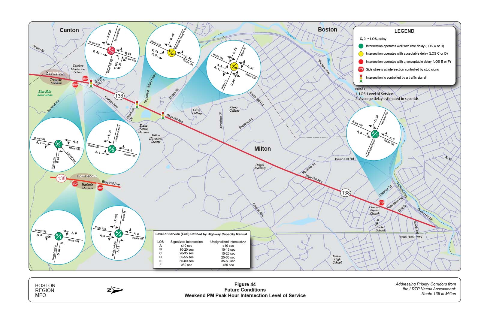
Aside from the intersection at Brush Hill Road, which operates at LOS F and LOS E during the AM and PM peak hours, the capacity analyses show mostly acceptable conditions throughout the corridor. Even the unsignalized side streets in the study area generally experience acceptable levels of delay. The main exception is at Neponset Valley Parkway, which operates at LOS E during the AM peak hour and LOS F during the PM peak hour.
The results of the Synchro model may seem overly optimistic, as congestion is a known issue in this region. But the discrepancy is partially attributed to peak spreading: The HCM uses an analysis period of 15 minutes to calculate delay, whereas the queues in Milton continue building for hours across the lengthy morning and evening peak travel periods. The traffic volumes are also necessarily based on counts at the intersections, which show the entry volume for each intersection. This number may be much smaller than the demand volume during peak hours.
Traffic signals are valuable devices for controlling vehicular and pedestrian traffic. Signals that are properly designed, located, operated, and maintained will provide orderly movement of traffic, reduce congestion, and reduce the frequency and severity of certain types of crashes (especially right-angle collisions). However, traffic control signals are not solutions to all problems at intersections. Poorly designed and maintained, ineffectively placed, improperly operated, or unjustified traffic control signals can result in excessive delays, a significant increase in crashes (especially the rear-end type), and diversion of traffic to less adequate routes as road users attempt to avoid delay produced by signals.
The process of evaluating the suitability of a traffic signal for a given intersection is called “signal warrant analysis.” The Manual on Uniform Traffic and Control Devices (MUTCD) provides a procedure for performing signal warrant analysis based on nine different criteria, referred to as warrants.23 MPO staff selected five warrants based on available data and relevance to the study, and evaluated each at eight of the intersections within the study area. In some cases, performing the warrant analysis was dependent on turning movement data and was therefore limited to peak hours. Table 5 presents results of the traffic signal warrant analyses. Appendix C contains more detailed worksheets.
The signal warrant analysis confirms that the existing signals at Brush Hill Road, Milton Street, Cheever Street, and Brook Road are appropriate because each location satisfies at least one signal warrant. It also shows that Neponset Valley Parkway is an excellent candidate for receiving a signal because it satisfies Warrants 1 through 3. Oak Street was of interest primarily as a pedestrian crossing location. Because vehicular traffic is relatively low, it does not meet traffic signal criteria. However, it does satisfy MUTCD criteria for pedestrian hybrid beacons.24 Chapter 7 discusses this conclusion and incorporates it into the design recommendations.
Table 5
Summary of Signal Warrant Analysis
| Intersection |
Has Signal? |
Warrant 1 |
Warrant 2 |
Warrant 3 |
Warrant 4 |
Warrant 7 |
|---|---|---|---|---|---|---|
Brush Hill Road |
Yes |
Satisfied |
Satisfied |
Satisfied |
Not |
Not |
Neponset Valley Parkway |
No |
Satisfied |
Satisfied |
Satisfied |
Not |
Not |
Milton Street / Dollar Lane |
Yes |
Not |
Satisfied |
Satisfied |
Not |
Not |
Atherton Street / Bradlee Road |
Yes |
Not |
Not |
Not |
Not |
Not |
Robbins Street |
Yes |
Not |
Not |
Not |
Not |
Not |
Cheever Street / Blue Hill Terrace |
Yes |
Not |
Not |
Satisfied |
Not |
Not |
Oak Street |
No |
Not |
Not |
Not |
Not |
Not |
Brook Road |
Yes |
Not |
Satisfied |
Not |
Not |
Not |
Note: Warrants 1–3 at Brook Road, Warrant 3A (peak hour delay) at all intersections, and Warrant 4 at all intersections were evaluated during peak hours only (6:00 AM–9:00 AM and 3:00 PM–6:00 PM).
Source: Central Transportation Planning Staff.
The existing signals at Atherton Street and Robbins Street do not satisfy any of the five warrants used during this study. However, they each have other factors that justify the presence of a signal. The signal at Atherton Street helps reduce confusion caused by the complex five-leg intersection geometry. It also allows safe and rapid access to Route 138 from the fire station immediately adjacent to the intersection. Robbins Street meets Route 138 at an oblique angle, resulting in a very wide intersection with poor visibility. The signal at that intersection helps to mitigate the problems caused by its geometry. A signal is also needed to allow pedestrians to cross from the sidewalk north of Robbins Street, which is only present on the east side of the road, to the sidewalk south of Robbins Street, which is only present on the west side of the road. Therefore, maintaining a signal at both of these locations was deemed appropriate based on engineering judgment.
Chapter 6—Community Engagement
Stakeholder participation is a crucial part of any project, and the residents who use the Route 138 corridor are among the most important stakeholders. Hence, MPO staff used a number of methods to engage the community in planning for improvements to the study area.
MPO staff developed a survey to help determine the public’s opinion about the problems on Route 138 in Milton and to learn their ideas for resolving them. The online survey that was posted on the Town of Milton website received 740 responses between March 22, 2018 and April 29, 2018. The fact that 45 percent of responses came within the first two days of the posting speaks to strong community engagement in Milton. Figure 19 presents the questions contained in the survey, along with the answers received. More than one-third of respondents left significant free-response feedback for one or more questions; those comments are included in Appendix G.
Some notable conclusions drawn from the survey are
Feedback from the survey was very helpful both to gauge community sentiment and to solicit ideas for solutions to the existing problems. Some of the ideas presented in the comments section were used while developing the design alternatives discussed in Chapter 7.
The Town of Milton has set up a map-based community survey for the Milton Complete Streets Prioritization Plan at wikimapping.com. This website allows users to encode a written comment onto a map at a specific location.25 MPO staff examined a sample of these comments in addition to the responses to the town website survey.
Figures 1 through 3 in Appendix G show some of the common comments encountered in the wikimapping data. Overall the responses mirrored many of the themes from the town website survey:
Chapter 7—Improvement Concepts
MPO staff, working with the study’s advisory task force, developed improvement concepts that could transform Route 138 in Milton into a pedestrian-and-bicyclist-friendly transportation corridor that serves all modes of transportation safely and maintains regional travel capacity by connecting people and their destinations. Many of the concepts for improvements that staff developed would be carried out within the existing roadway’s right-of-way and would account for the needs of abutters and roadway users. Most of the improvements could be completed in the short-term as funding for the project had already been allocated and programmed in the 2020 Transportation Improvement Program (TIP).
The corridor was divided into three segments based on land use and traffic volume:
This segment extends is in the southern part of corridor. It is surrounded primarily by the park and open spaces of Blue Hills Reservation, and a low-density residential neighborhood of detached one‐family dwellings. This segment has the highest levels of traffic and congestion in the study area, and carries about 37,000 vehicles per day. Here, the strategy was to evaluate different roadway cross-sections to improve safety and, operations, and make the roadway more pedestrian-and-bicyclist friendly. MPO staff developed two alternatives for consideration based on discussions with the task force.
Alternative 1 (shown in Figures 20 and 21) consists of a three-lane cross-section—one southbound lane and two northbound lanes and a multi-use path on the east side of the roadway.
Advantages
Disadvantages
Alternative 2 (shown in Figures 22 and 23) maintains the existing roadway cross-section—one travel lane each direction, a bicycle lane and sidewalk on either side of the roadway, and a midblock crosswalk in the vicinity of the south parking facility.
Advantages
Disadvantages
Figure 23 shows the improvement concept for the redesign of Route 138 and Canton Avenue. The concept would improve safety for pedestrians and bicyclists by
This segment is the middle part of the corridor. The area surrounding the roadway is primarily low-density residential neighborhoods of detached one‐family dwellings. This segment has medium- to-high traffic volumes (between 15,000 and 25,000 vehicles per day); and congestion and queuing occur primarily during the PM peak period. For this segment, the strategy is similar to that of the Blue Hill Reservation area—to evaluate different roadway cross-sections to improve safety, operations, and make the roadway more pedestrian-and-bicyclist friendly. MPO staff developed two alternatives for consideration based on discussions with the task force.
Alternative 1 (shown in Figures 24 through 29) maintains the two-lane cross-section, installs northbound left-turn lanes at the Neponset Valley Parkway and Milton Street intersections, and builds a multi-use path on the east side of the roadway. Additional improvement concepts include signalizing the intersection of Route 138 and Neponset Valley Parkway.
Advantages
Disadvantages
Alternative 2 (shown in Figures 30 through 35) maintains the existing two-way roadway cross-section, installs left-turn lanes at selected intersections, and a bicycle lane and sidewalk on either side of the roadway. Additional improvement concepts include signalizing the intersection of Route 138 and Neponset Valley Parkway.
Advantages
Disadvantages
Tables 6 through 9 show additional improvement concepts for the intersections that could be incorporated into either alternative. The time frame categorized as short-term is typically less than three years. Short-term improvements are relatively uncomplicated and inexpensive to implement, and require minimal design efforts. Medium-term is typically between three and five years. Medium-term improvements are more complicated than their short-term counterparts and require more funding resources and design and engineering efforts. Long-term improvements typically require five or more years to plan and implement. They require more design and engineering efforts, environmental permitting, and larger funding resources. Cost estimates for each improvement were categorized as low (less than $10,000), medium ($10,000 to $500,000), and high ($500,000 or more). Because there is a funded project for this corridor, some of the medium- or long-term improvements might be incorporated into that project.
Route 138 at Brush Hill Road: Allow Northbound Left Turns
As a result of feedback from the town engineer, MPO staff investigated the effects of permitting left turns from Route 138 northbound onto Brush Hill Road westbound. Currently, this turning movement is prohibited and vehicles are instead required to use Canton Avenue to access Brush Hill Road. The suggestion from the town would restore this movement and add a protected left-turn bay to the northbound approach.
From a safety standpoint, adding a left turn bay would have advantages and disadvantages. The primary benefit, and the main concern as voiced by the town, would be a reduction in weaving maneuvers on the short segment of Brush Hill Road between Canton Avenue and Route 138. Under the existing configuration, most of the left turns from Brush Hill Road westbound come from southbound traffic on Canton Avenue, while most of the through-traffic comes from Route 138 northbound via Canton Avenue. These two traffic streams, which exceed 100 vehicles per hour during the peak periods, must weave past each other within about 200 feet to reach the appropriate lane. Permitting left turns from Route 138 northbound would remove most of the through traffic off Brush Hill Road and eliminate the need for a weave.
The primary safety drawback of using the proposed configuration is that it would come at the cost of adding a second receiving lane on the Route 138 northbound approach. This recommendation, which is illustrated in Figure 24, improves safety at the intersection by removing the need for westbound left turns and eastbound right turns to merge into a single lane during their shared signal phase. The existing right-of-way in the vicinity of Brush Hill Road is 50 feet and would not provide enough space for two southbound lanes and two northbound lanes (one through-lane and one left-turn bay) without land takings. The collision data obtained by CTPS did not show any crashes resulting from either the weave or the merge maneuvers, so it is not clear which of the two issues presents the greater safety risk.
From an operations standpoint, Synchro level-of-service analysis showed slightly increased intersection delay for the PM and weekend peak hours. The increased delay is primarily experienced by southbound traffic that must yield some effective green time to the northbound left-turn traffic. During the AM peak hour, when southbound traffic is lower, the analysis showed slightly decreased delay after the addition of a left-turn bay. These results suggest that the town’s suggestion should be viable operationally, even if it does not represent the optimal traffic configuration. Table F–2 in Appendix F summarizes the level-of-service analysis for this design option.
Table 6
Route 138 at Brush Hill Road
| Issue |
Improvement |
Time Frame |
Cost |
Jurisdiction |
|---|---|---|---|---|
Congestion |
Consider adding a northbound left-turn lane on Route 138 at Brush Hill to reduce weaving on the westbound approach |
Medium |
Medium |
MassDOT |
Congestion |
Optimize traffic signal timings |
Short-term |
Low |
MassDOT |
Safety and congestion |
Upgrade signal equipment |
Medium-term |
Medium |
MassDOT |
Safety and congestion |
Widen the southbound receiving approach to two lanes. |
Short-term |
Medium |
MassDOT |
Safety |
Align signal heads to improve visibility at each approach. |
Short-term |
Low |
MassDOT |
Safety |
Trim vegetation on the approaches to improve visibility of the signal heads. |
Short-term |
Low |
MassDOT |
Safety |
Install crosswalk with ADA curb ramps. |
Medium-term |
Medium |
MassDOT |
Safety and congestion |
Add do not block intersection crosshatch pavement markings to prevent queues from blocking the intersection. |
Short-term |
Low |
MassDOT |
Safety |
Install additional street lighting to improve safety and security for users. |
Medium-term |
Medium |
MassDOT |
Source: Central Transportation Planning Staff.
Table 7
Route 138 at Neponset Valley Parkway
| Issue |
Improvement |
Time Frame |
Cost |
Jurisdiction |
|---|---|---|---|---|
Congestion |
Install new traffic signal
|
Medium-term |
High |
MassDOT |
Safety and congestion |
Add a Route 138 northbound left-turn lane |
Medium-term |
Medium |
MassDOT |
Safety |
Trim vegetation on the approaches to improve visibility of the signal heads. |
Short-term |
Low |
MassDOT |
Safety |
Install crosswalk with ADA curb ramps. |
Short-term |
Low |
MassDOT |
Safety and congestion |
Add do not block intersection crosshatch pavement markings to prevent queues from blocking the intersection. |
Short-term |
Low |
MassDOT |
Safety |
Install additional street lighting to improve safety and security for users. |
Medium-term |
Medium |
MassDOT |
Source: Central Transportation Planning Staff.
Table 8
Route 138 at Milton Street/Dollar Lane Intersection
| Issue |
Improvement |
Time Frame |
Cost |
Jurisdiction |
|---|---|---|---|---|
| Congestion |
Optimize traffic signal timings |
Short-term |
Low |
MassDOT |
Safety and congestion |
Upgrade signal equipment |
Medium-term |
Medium |
MassDOT |
Safety and congestion |
Add a Route 138 northbound left-turn lane |
Medium-term |
Medium |
MassDOT |
Safety |
Install “(RED) SIGNAL AHEAD” advance warning signs to warn road users of upcoming traffic lights |
Short-term |
Medium |
MassDOT |
Safety |
Align signal heads to improve visibility at each approach. |
Short-term |
Low |
MassDOT |
Safety |
Trim vegetation on the approaches to improve visibility of the signal heads. |
Short-term |
Low |
MassDOT |
Safety |
Install crosswalk with ADA curb ramps. |
Medium-term |
Medium |
MassDOT |
Safety and congestion |
Add do not block intersection crosshatch pavement markings to prevent queues from blocking the intersection. |
Short-term |
Low |
MassDOT |
Safety |
Install additional street lighting to improve safety and security for users. |
Medium-term |
Medium |
MassDOT |
Source: Central Transportation Planning Staff.
Table 9
Route 138 at Atherton Street/Bradlee Road Intersection
| Issue |
Improvement |
Time Frame |
Cost |
Jurisdiction |
|---|---|---|---|---|
Congestion |
Optimize traffic signal timings |
Short-term |
Low |
MassDOT |
Safety and congestion |
Upgrade signal equipment |
Medium-term |
Medium |
MassDOT |
Safety and congestion |
Install additional signal heads on Bradlee Road to stop vehicles for emergency preemption. |
Medium-term |
Medium |
MassDOT |
Safety |
Install “(RED) SIGNAL AHEAD” advance warning signs to warn road users of upcoming traffic lights |
Short-term |
Medium |
MassDOT |
Safety and access management |
Open the island in front of the Fire Station to provide emergency vehicles direct access to the intersection when queued vehicles are present on either the Atherton Street or Bradlee Road eastbound approaches. |
Medium-term |
Medium |
MassDOT |
Safety and access management |
Reduce width of the driveways to the Fire Station and add signage/pavement markings to limit access only to fire/rescue equipment. |
Medium-term |
Medium |
MassDOT |
Safety |
Align signal heads to improve visibility at each approach. |
Short-term |
Low |
MassDOT |
Safety |
Trim vegetation on the approaches to improve visibility of the signal heads. |
Short-term |
Low |
MassDOT |
Safety |
Install crosswalk with ADA curb ramps. |
Medium-term |
Medium |
MassDOT |
Safety and congestion |
Add “No Turn on Red” signs to the approaches of Atherton Street and Bradlee Road. |
Short-term |
Low |
MassDOT |
Safety |
Install additional street lighting to improve safety and security for users. |
Medium-term |
Medium |
MassDOT |
Source: Central Transportation Planning Staff.
This is the northern segment of the corridor. The land uses surrounding the roadway consist of high-density residential neighborhoods of one- and two-family dwellings. This segment has the lowest levels of traffic in the corridor (between 10,000 and 12,000 vehicles per day); and has sidewalks and 10-foot wide shoulders on either side of the roadway. The 10-foot wide shoulders are primarily used as on-street parking, but are not authorized. The strategy is to enhance safety for pedestrians and bicycles and make the roadway more pedestrian-and-bicyclist friendly.
Figure 36-38 show the improvements in Alternative 1. Staff developed Alternative 1 (shown in Figures 36 through 38) to address concerns about residential parking. Alternative 1 maintains the two-lane cross-section and sidewalks on either side of the roadway and converts one of the 10-foot shoulders into a two-way bike lane or multi-use path. The other shoulder would provide authorized on-street parking for residents.
Advantages
Disadvantages
Alternative 2 (shown in Figures 39 through 41) maintains the existing two-way roadway cross-section and sidewalks on either side of the roadway, and converts the shoulders into buffered bicycle lanes.
Advantages
.
Disadvantages
One
Tables 10 through 13 present additional improvement concepts for the intersections that could the incorporated into either alternative.
Table 10
Route 138 at Robbins Street
| Issue |
Improvement |
Time Frame |
Cost |
Jurisdiction |
|---|---|---|---|---|
Congestion |
Optimize traffic signal timings |
Short-term |
Low |
MassDOT |
Safety and congestion |
Upgrade signal equipment |
Medium-term |
Medium |
MassDOT |
Safety and congestion |
Add “No Turn on Red” signs to the approaches of Atherton Street and Bradlee Road. |
Short-term |
Low |
MassDOT |
Safety |
Align signal heads to improve visibility at each approach. |
Short-term |
Low |
MassDOT |
Safety |
Trim vegetation on the approaches to improve visibility of the signal heads. |
Short-term |
Low |
MassDOT |
Safety |
Install crosswalk with ADA curb ramps. |
Medium-term |
Medium |
MassDOT |
Safety |
Install additional street lighting to improve safety and security for users. |
Medium-term |
Medium |
MassDOT |
Source: Central Transportation Planning Staff.
Table 11
Route 138 at Cheever Street/Blue Hill Terrace Street
| Issue |
Improvement |
Time Frame |
Cost |
Jurisdiction |
|---|---|---|---|---|
Congestion |
Optimize traffic signal timings |
Short-term |
Low |
MassDOT |
Safety and congestion |
Upgrade signal equipment |
Medium-term |
Medium |
MassDOT |
Safety and congestion |
Add “No Turn on Red” signs to the approaches of Cheever Street and Blue Hill Terrace Street. |
Short-term |
Low |
MassDOT |
Safety |
Align signal heads to improve visibility at each approach. |
Short-term |
Low |
MassDOT |
Safety |
Trim vegetation on the approaches to improve visibility of the signal heads. |
Short-term |
Low |
MassDOT |
Safety |
Upgrade sidewalks and curb ramps |
Medium-term |
Medium |
MassDOT |
Safety |
Add curb bump-outs or extensions to shorten crosswalks and improve visibility at intersections |
Medium-term |
Low |
MassDOT |
Safety |
Install additional street lighting to improve safety and security for users. |
Medium-term |
Medium |
MassDOT |
Source: Central Transportation Planning Staff.
Table 12
Route 138 at Aberdeen Road and Oak Street
| Issue |
Improvement |
Time Frame |
Cost |
Jurisdiction |
|---|---|---|---|---|
Safety and pedestrian accommodation |
Install a pedestrian-activated crossing signal at Oak Street to provide safer crossing for students or Move the pedestrian-activated crossing signal at Aberdeen Road to Tucker Street to serve both students and church activities |
Medium-term |
Medium |
MassDOT |
Pedestrian accommodation |
Upgrade sidewalks, crosswalks, and curb ramps to MassDOT standards. |
Medium-term |
Medium |
MassDOT |
Safety |
Add street curb bump-outs or extensions to shorten crosswalks and improve visibility at intersections |
Medium-term |
Low |
MassDOT |
Source: Central Transportation Planning Staff.
Table 13
Route 138 at Brook Road
| Issue |
Improvement |
Time Frame |
Cost |
Jurisdiction |
|---|---|---|---|---|
Congestion |
Optimize traffic signal timings |
Short-term |
Low |
MassDOT |
Safety and congestion |
Upgrade signal equipment |
Medium-term |
Medium |
MassDOT |
Safety and congestion |
Add “No Turn on Red” signs to the approaches of Cheever Street and Blue Hill Terrace Street. |
Short-term |
Low |
MassDOT |
Safety |
Align signal heads to improve visibility at each approach. |
Short-term |
Low |
MassDOT |
Safety |
Trim vegetation on the approaches to improve visibility of the signal heads. |
Short-term |
Low |
MassDOT |
Safety |
Upgrade sidewalks and curb ramps |
Medium-term |
Medium |
MassDOT |
Safety |
Install additional street lighting to improve safety and security for users. |
Medium-term |
Medium |
MassDOT |
Safety |
Add street curb bump-outs to shorten crosswalks and improve visibility |
Medium-term |
Low |
MassDOT |
Source: Central Transportation Planning Staff.
Chapter 8—Performance of Future Conditions
Planners typically use models to forecast future traffic volumes systematically based on changes in the transportation network or land use. For this study, MPO staff used the statewide travel demand model set. Using this model, staff projected that between now and 2040, traffic volume on Route 138 in Milton would remain at current levels because of congestion and repurposing developments in the corridor.
To test the impact of future traffic conditions that would result from proposed improvements, MPO staff used the projected peak-hour turning movement volumes. Figures 42 through 44 show the expected performance of the signalized and unsignalized intersections after implementing the proposed improvements. The analyses indicate that the intersections would operate satisfactorily during the peak hours. Appendix F contains LOS results for the future conditions.
MPO staff evaluated what would be the future LOS of Route 138 in Milton if the recommendations from this study were implemented. Appendix F contains results of the pedestrian LOS score card analyses, and the ratings, as related to the four goals areas emphasized in the MPO’s Long-Range Transportation Plan (LRTP). Based on the assessment, Route 138 was rated good in terms of meeting the MPO’s goals for capacity management and mobility and economic vitality because of prioritizing safe accommodations for pedestrians and bicyclists, improving connectivity of the pedestrian network, and providing infrastructure for people with disabilities.
Each of the proposed improvements discussed in Chapter 7 was chosen to target specific safety deficiencies present in the study area. The Highway Safety Manual (HSM) cost-benefit analysis is performed on the basis of reduced collisions; in the case of the existing conditions these were mostly vehicular crashes because of the absence of pedestrian and bicycle facilities on a significant portion of the corridor. However, the improvement concepts primarily target pedestrians and bicyclists, as they are Complete Streets solutions. The HSM analysis will show multimodal improvements as having a negative safety impact because increased participation in these modes exposes a larger number of users to risk. Nonetheless, several concepts proposed in the study do have high-quality data to justify their safety benefits.
Chapter 9—Conclusion and Next Steps
MPO staff worked with the study’s advisory task force members to develop solutions for addressing the pedestrian and bicyclist issues, and traffic safety and operations problems identified in the corridor. The concepts include short-, medium-, and long-term improvements. Short-term improvements usually are low-cost improvements and long-term improvements usually are high-cost improvements. MPO staff qualitatively assigned each improvement concept to one of the following cost categories: low cost, less than $10,000; medium cost, $10,000 to $500,000; and high cost, greater than $500,000. These are preliminary cost estimates that do not include the costs of acquiring lands adjacent to the roadway, which may be required for some of the improvements.
The short-term improvements are relatively uncomplicated and inexpensive to implement, and require minimal design efforts. They include sign installation; pavement markings; in-pavement detection for bicycles; countdown timers for pedestrians; high-visibility crosswalks; traffic signal retiming; and upgrades to signal-head backplates.
The medium-term improvements are more complicated and require more funding resources and design and engineering efforts. Medium-term improvements include installing pedestrian-activated midblock crosswalks; reconfiguring existing roadway shoulders into bicycle lanes; drainage improvements; upgrading signal equipment to include an Opticom system for emergency preemption; reconstructing substandard sidewalks; geometric modifications; and managing access to driveways.
The long-term improvements typically require more design and engineering efforts, environmental permitting, and larger funding resources. They include improving street lighting; installing new sidewalks; reconstructing intersections to improve safety; capacity management and mobility; and installing new traffic signals.
If implemented, the improvements proposed in this report would yield the following benefits:
The federal fiscal year (FFY) 2019–23 Transportation Improvement Program (TIP) includes a project (Resurfacing and Related Work on Route 138) programmed in FFY 2020, to address some of the problems identified in this study. Currently, the emphasis is on providing Complete Streets solutions for the corridor and successful implementation would require cooperation between MassDOT Highway Division and the Town of Milton to ensure that sidewalks, bicycle lanes, or multi-use paths are continuous and connected; and to ensure that MassDOT’s standards guide the design of roadway elements. It is important for stakeholders to examine the concepts with all road users in mind. MassDOT owns Route 138 and would be responsible for implementing renovations to the roadway and intersections. The Town of Milton owns the majority of the side streets and would be responsible for implementing renovations on those streets. The Department of Conservation and Recreation (DCR) owns some of the roadways (Neponset Valley Parkway and Green Street) and facilities in the Blue Hills Reservation and would be responsible for implementing improvements for those facilities.
Transportation decision making is complex and is influenced by factors such as financial limitations and agencies’ programmatic commitments. Project development is the process that takes transportation improvements from concept to construction. This process will depend upon cooperation between MassDOT, the Town of Milton, and the Boston Region MPO. This planning study provides the necessary information for the project proponents to initiate the project notification and review process. After completing these initial steps, the proponents can start preliminary design and engineering and begin working with the MPO to program funding for the project in the TIP. Appendix H contains an overview of the project development process.
SA/sa
1 An HSIP crash cluster is a location in which the number and severity of crashes—as measured on the Equivalent Property Damage Only (EPDO) index—ranks the location among the top five percent of crash clusters in the region. The EPDO method assigns weighted values to each crash based on whether the crash resulted in property damage (unweighted), injury (weighted by 5), or a fatality (weighted by 10).
2 Boston Region Metropolitan Planning Organization, Charting Progress to 2040: The New Long-Range Transportation Plan of the Boston Region Metropolitan Planning Organization, endorsed by the Boston Region MPO on July 30, 2015.
3 Boston Region Metropolitan Planning Organization, Unified Planning Work Program, Federal Fiscal Year 2017, endorsed by the Boston Region Metropolitan Planning Organization on July 28, 2016.
4 Safety Conditions: The location has a higher-than-average crash rate for its functional class; contains a crash cluster that makes it eligible for Highway Safety Improvement Program (HSIP) funding; contains a crash location on MassDOT Highway Division’s Top High Crash Locations Report; or has a significant number of pedestrian and bicycle crashes (two or more per mile).
5 Congested Conditions: The travel time index is at least 1.3. The travel time index is the ratio of the peak-period travel time to the free-flow travel time.
6 Multimodal Significance: The roadway carries one or more bus routes or is adjacent to a transit stop or station; the roadway supports bicycle or pedestrian activities or there is a project planned that will support these activities; there is a need to accommodate pedestrians and bicyclists and improve transit on the roadway; or there is a significant amount of truck traffic on the roadway serving regional commerce.
7 Regional Significance: The roadway is on the National Highway System; carries a significant portion of regional traffic (Average Daily Traffic of 20,000 vehicles or more); lies within 0.5 miles of environmental-justice transportation analysis areas or zones; or is essential for the region’s economic, cultural, or recreational development.
8 Reginal Equity: To ensure that, over time, all subregions in the MPO’s planning area receive support from the MPO in the form of Unified Planning Work Program planning studies, during each funding cycle MPO staff select no more than one location per subregion to study, and choose a location in a different subregion from the location studied in the preceding cycle.
9 Implementation Potential: The study location is proposed by the jurisdictional agency or agencies for the roadway; proposed or prioritized by a Subregional group; or identified as a priority for improvement by other stakeholders.
10 Technical Memorandum, dated May 18, 2017, to the Boston Region Metropolitan Planning Organization, Federal Fiscal Year (FFY) 2017 Priority Corridors for Long-Range Transportation Plan (LRTP) Needs Assessment: Selection of Study Locations.
11 This vision aligns with the aims of the Healthy Transportation Compact, a key requirement of the landmark transportation reform legislation, signed into law in June 2009, which aims to facilitate transportation decisions that balance the needs of all transportation users, expand mobility, improve public health, support a cleaner environment, and create stronger communities.
12 Right-of-way is defined as the land, or interest therein, acquired for or devoted to a highway.
13 The minimum width for a sidewalk is five feet excluding the width of the curb. The measurement of a sidewalk sometimes includes the width of the curb. If this method of measurement is used, the minimum width of a sidewalk is 5.5 feet. In addition, sidewalks must have the necessary access features to comply with the federal Americans with Disabilities Act.
14 Data queried on MassDOT Highway Division’s Project Information Database on December 26, 2017. https://www.mass.gov/service-details/massdot-project-info.
15 Road Safety Audit, Blue Hill Avenue (Route 138) at Atherton Street/Bradlee Road and Blue Hill Avenue (Route 138) at Milton Street/Dollar Lane, MassDOT Project #607763, prepared for Massachusetts Department of Transportation, July 7, 2015.
16 An HSIP crash cluster is a location in which the number and severity of crashes—as measured on the Equivalent Property Damage Only (EPDO) index—ranks the location among the top five percent of crash clusters in the region. The EPDO method assigns weighted values to each crash based on whether the crash resulted in property damage (unweighted), injury (weighted by 5), or a fatality (weighted by 10).
17 Ryan Hicks and Casey-Marie Claude, Pedestrian Level-of-Service Memorandum, Technical Memorandum to the Boston Region Metropolitan Planning Organization, January 19, 2017.
18 Highway Safety Manual 2010, American Association of State Highway and Transportation Officials, Washington, DC, December 2010.
19 Yuanchang Xie and Chen (Julian) Chen, Calibration of Safety Performance Functions for Massachusetts Urban and Suburban Intersections. Report prepared for Massachusetts Department of Transportation Office of Transportation Planning, March 2016.
20 Technical Memorandum, dated January 1, 2018, to the Massachusetts Department of Transportation, MassDOT Average Comprehensive Crash Costs.
21 Highway Capacity Manual 2010, Transportation Research Board of the National Academies, Washington, DC, December 2010.
22 Trafficware Inc., Synchro Studio 9, Synchro plus SimTraffic, Build 914, Sugar Land, Texas.
23 Chapter 4C: Traffic Control Signal Needs Studies, Manual on Uniform Traffic Control Devices, 2009 Edition with Revisions 1 and 2, Federal Highway Administration, US Department of Transportation, May 2012.
24 Chapter 4F: Pedestrian Hybrid Beacons, Manual on Uniform Traffic Control Devices.
25 Milton Complete Streets Prioritization Plan. Retrieved March 1, 2018. http://wikimapping.com/wikimap/Milton.html.
26 Crash Modification Factors Clearinghouse, US Department of Transportation Federal Highway Administration, website, http://www.cmfclearinghouse.org/, August 14, 2018
27 Chen, L., C. Chen, and R. Ewing. “The Relative Effectiveness of Pedestrian Safety Countermeasures at Urban Intersections - Lessons from a New York City Experience.” Presented at the 91st Annual Meeting of the Transportation Research Board, January 22-26, Washington, DC, 2012.
28 Alluri et al. “Statewide Analysis of Bicycle Crashes.” Florida Department of Transportation (May 2017).
29 Elvik, R., Christensen, P., and Amundsen, A., “Speed and Road Accidents An Evaluation of the Power Model.” Oslo, Norway, Transportokonomisk Institutt, (2004)
30 Appiah et al. “Safety Effect of Dilemma-Zone Protection Using Actuated Advance Warning Systems.” Transportation Research Record: Journal of the Transportation Research Board, No. 2250, Transportation Research Board of the National Academies, Washington, D.C., 2011, pp. 19-24. DOI: 10.3141/2250-03.
Figure ES1
Summary of Alternatives
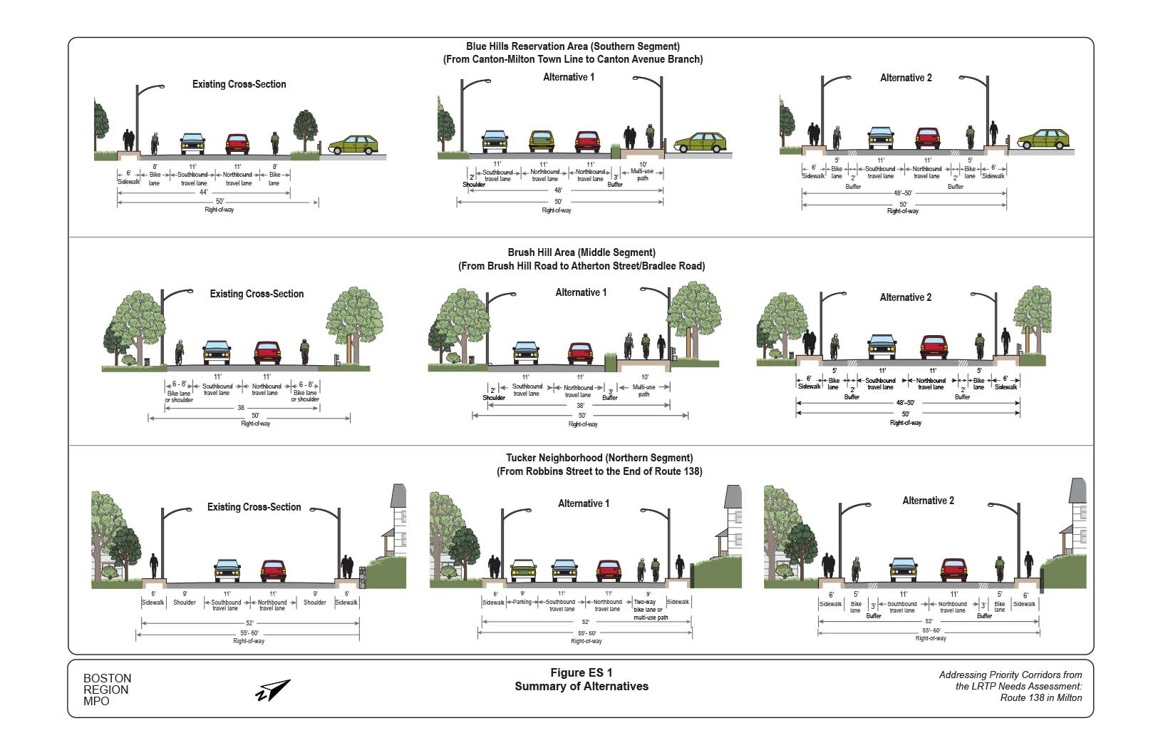
Figure 1
Regional Map of Study Area and Nearby Roadways
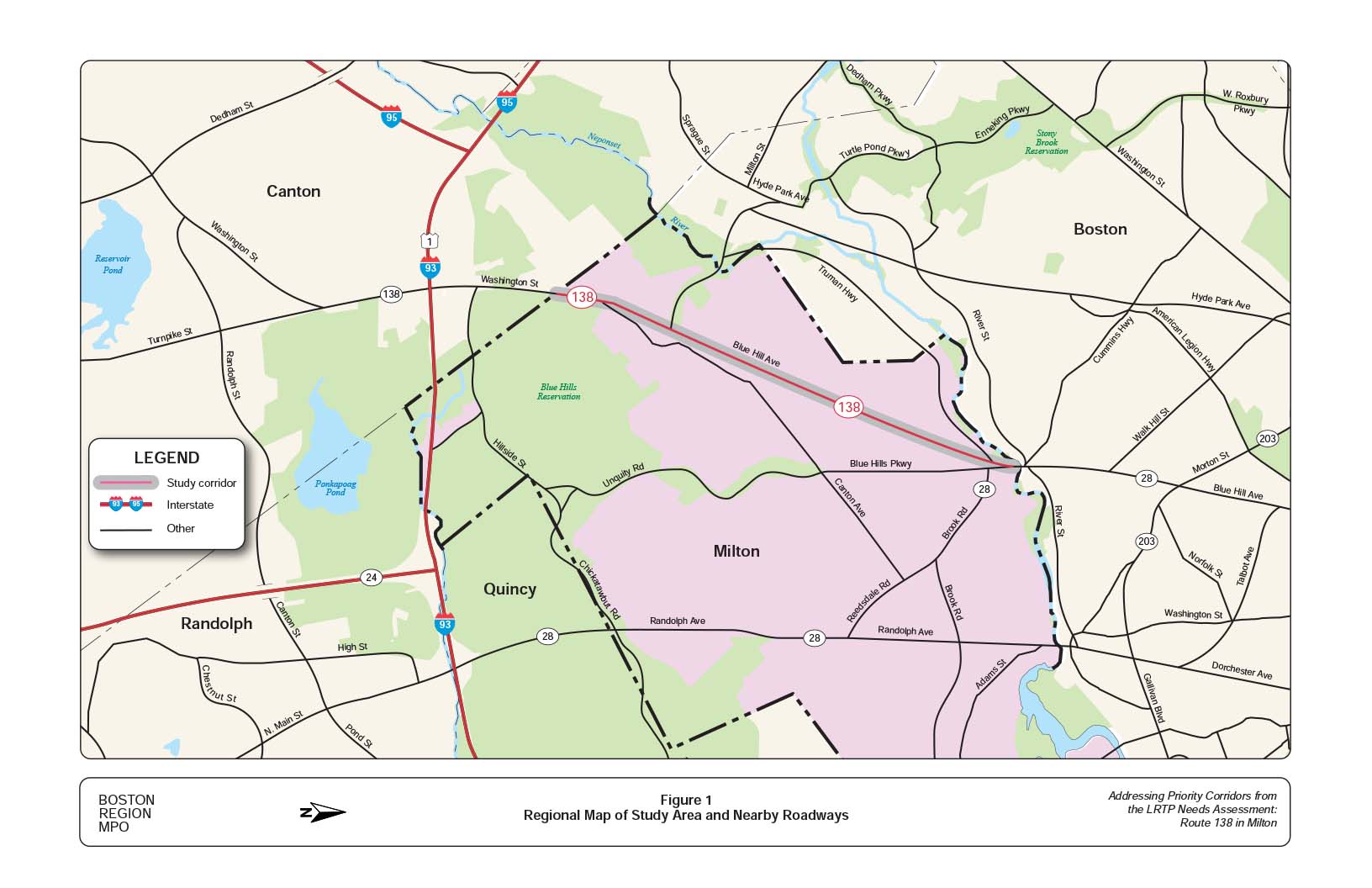
Figure 2
Jurisdiction of Roadways in the Route 138 Study Area
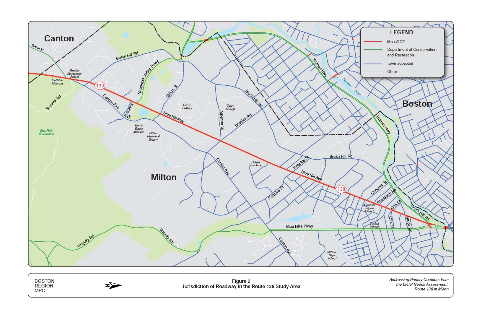
Figure 3
Width of Right of Way and Shoulders on Route 138 in Milton
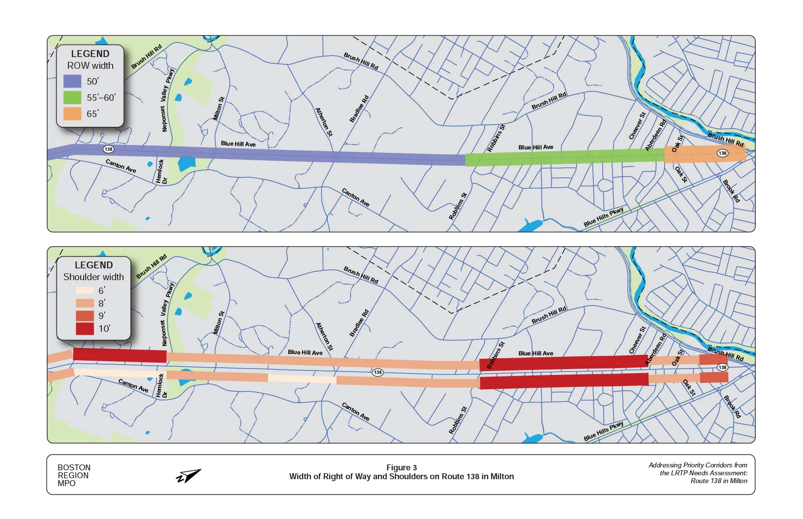
Figure 4
Locations of Existing Sidewalks on Route 138 in Milton
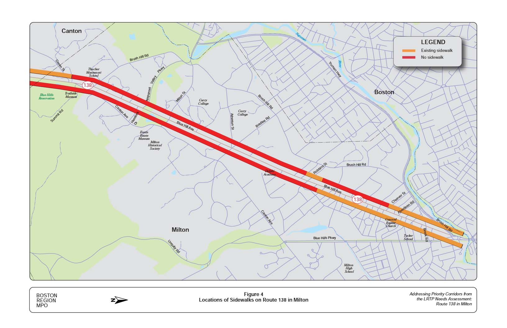
Figure 5
Study Intersections on Route 138 in Milton
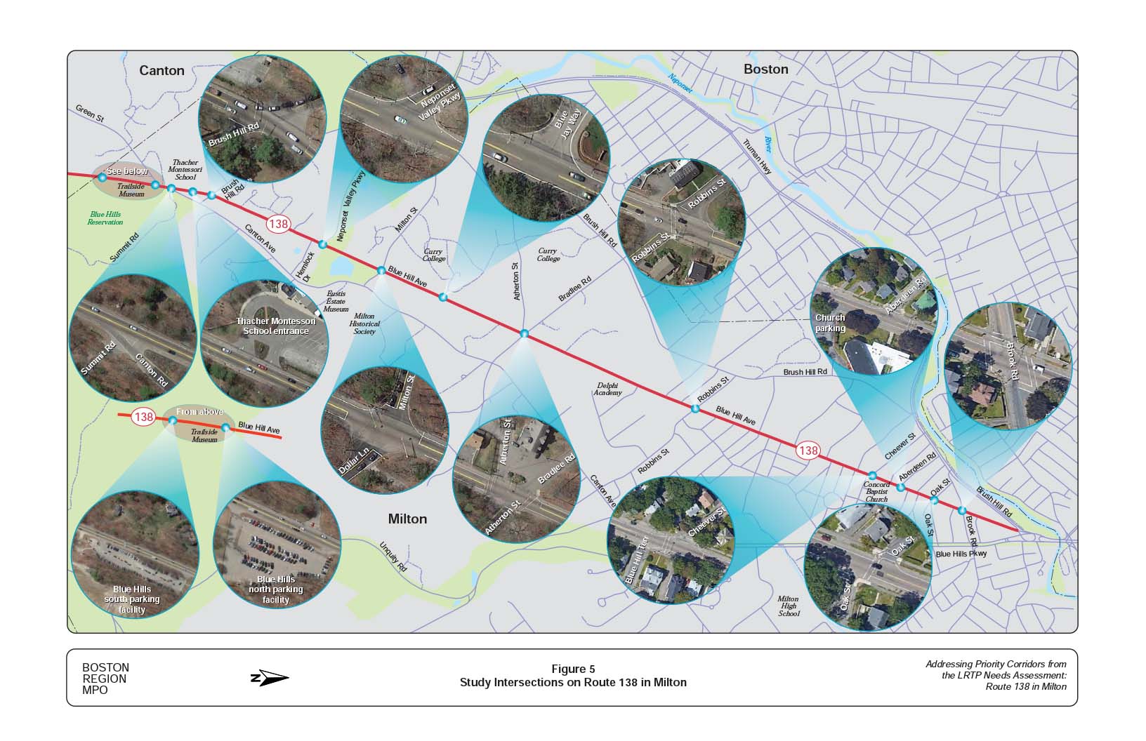
Figure 6
Land Use and Zoning Map along Route 138 in Milton
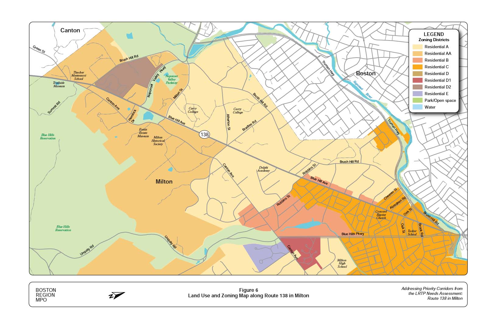
Figure 7
Weekday and Weekend Average Traffic Volumes on Route 138 in Milton
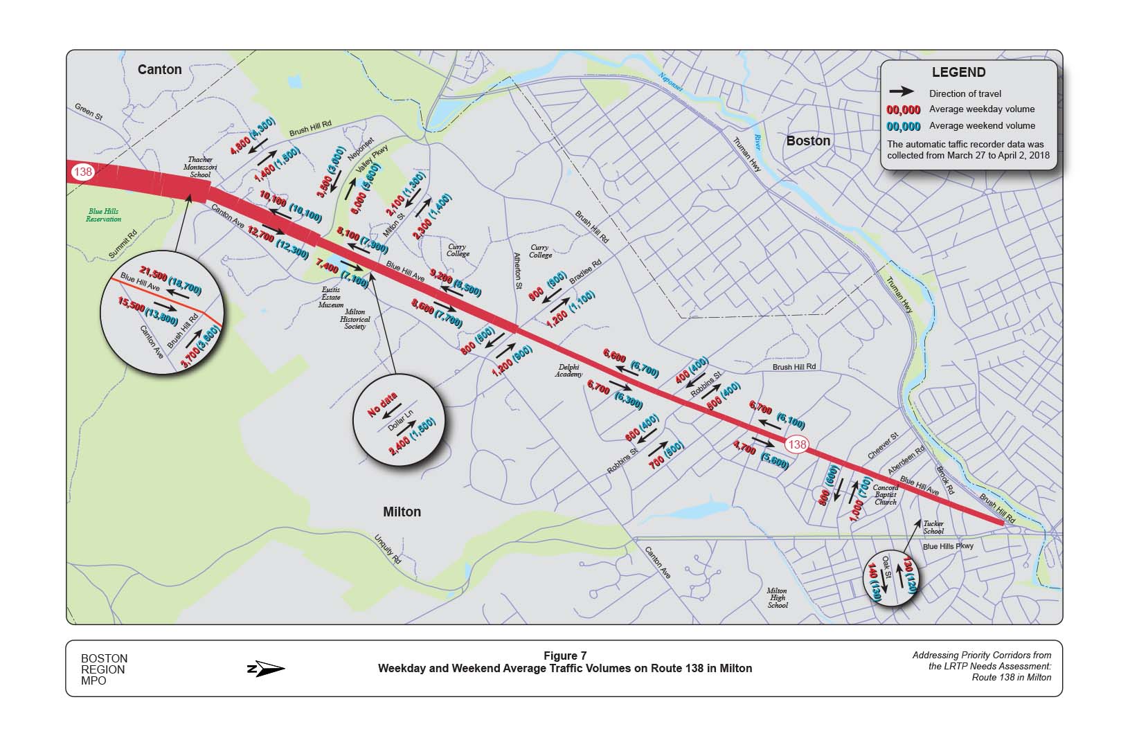
Figure 8
Weekday and Weekend Hourly Traffic-Volume Distribution on Route 138 in Milton
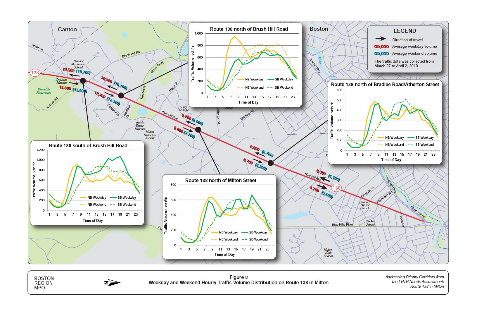
Figure 9
Turning Movement Volumes on Route 138 in Milton
Weekday AM and PM Peak Hour
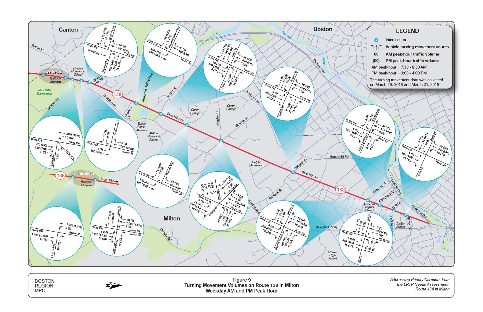
Figure 10
Turning Movement Volumes on Route 138 in Milton
Weekend AM and PM Peak Hour
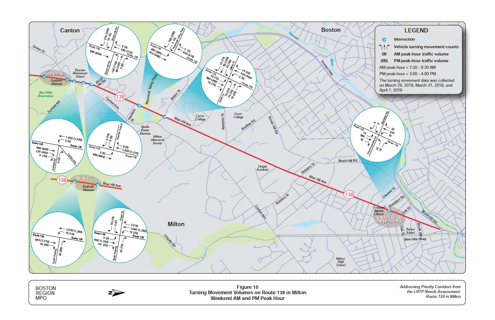
Figure 11
Peak Period Pedestrian Volumes
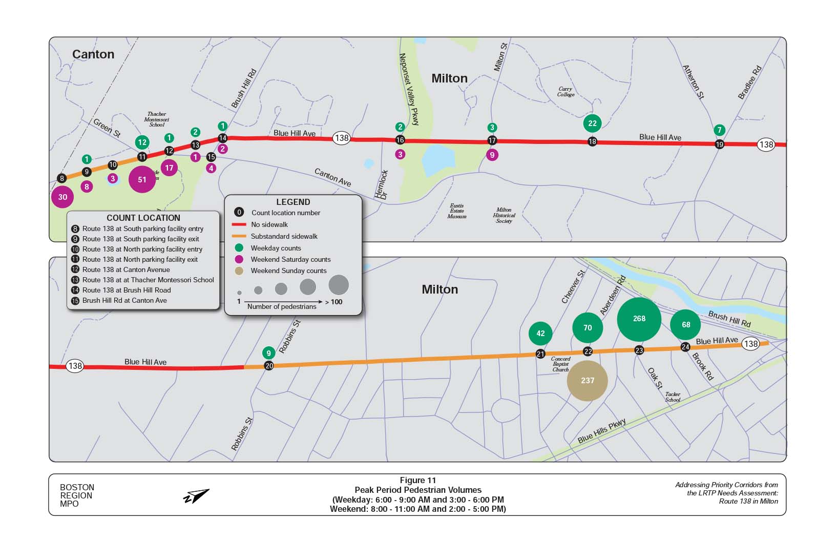
Figure 12
Peak Period Bicycle Volumes
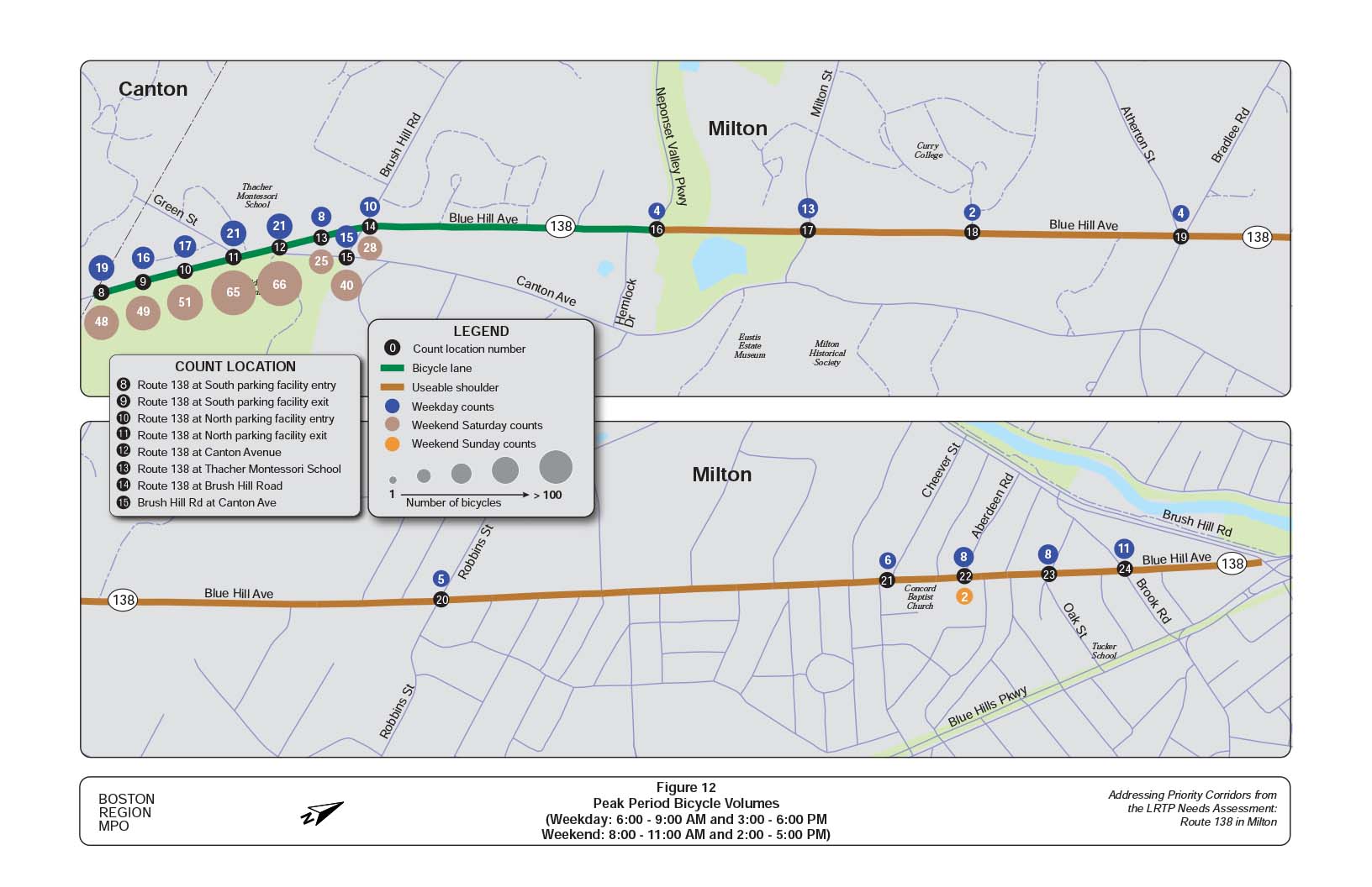
Figure 13
Observed Spot Speeds and Posted Speed Limits on Route 138 in Milton
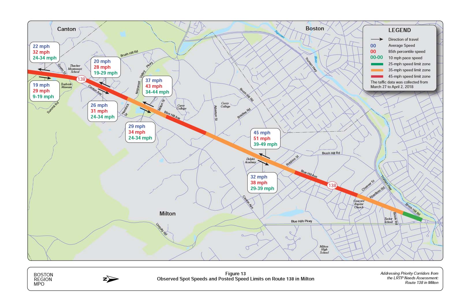
Figure 14
Crashes by Intersection and Segment (2011 - 2015)
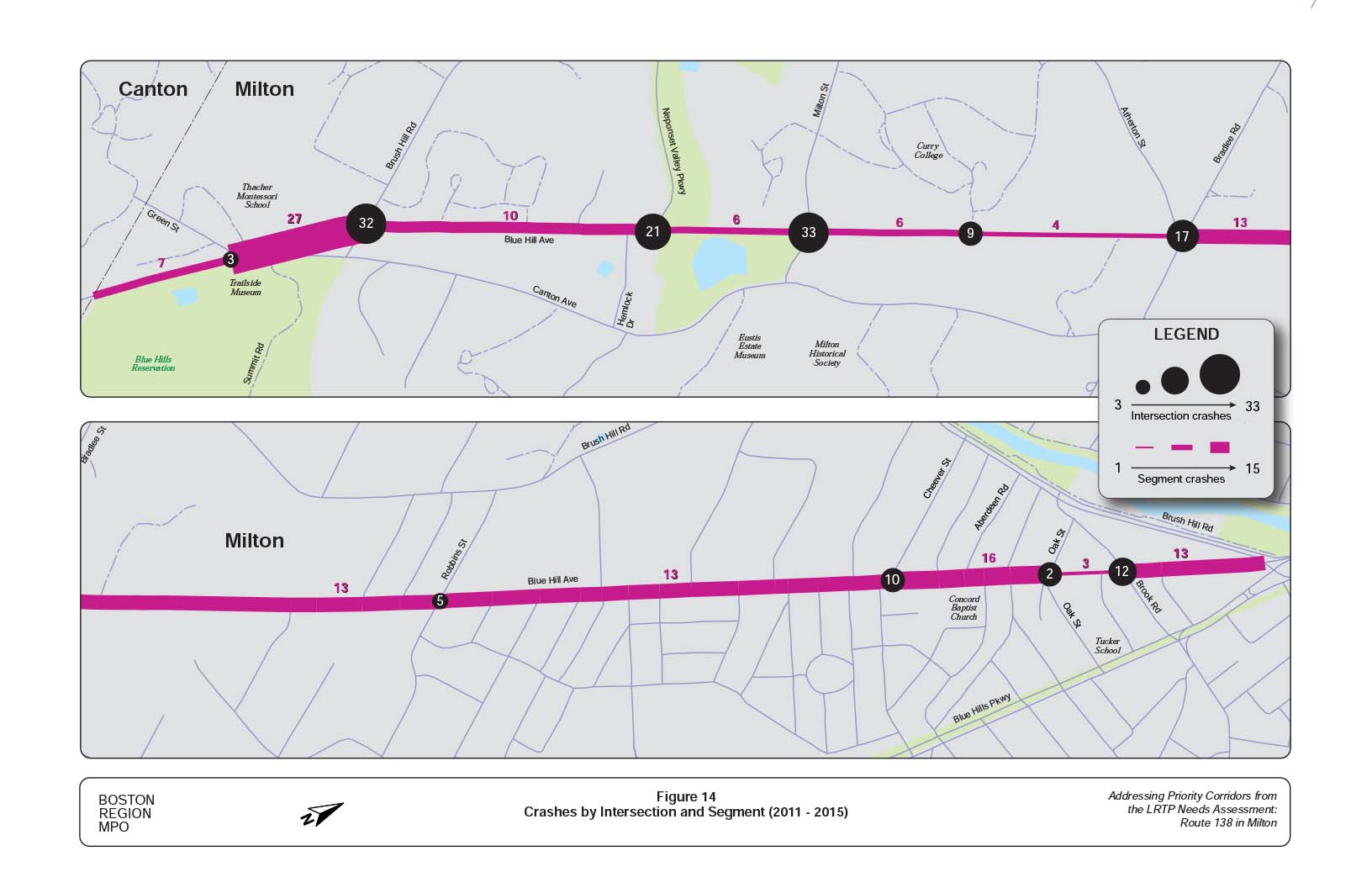
Figure 15 .
Observed and Expected Crashes by Intersection and Segment
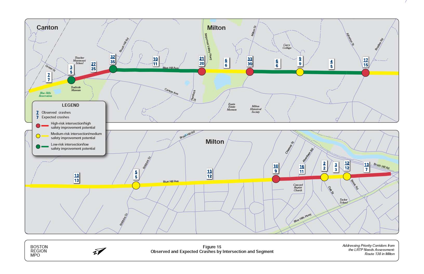
Figure 16
Existing Conditions
Weekday AM Peak Hour Intersection Level of Service

Figure 17
Existing Conditions
Weekday PM Peak Hour Intersection Level of Service
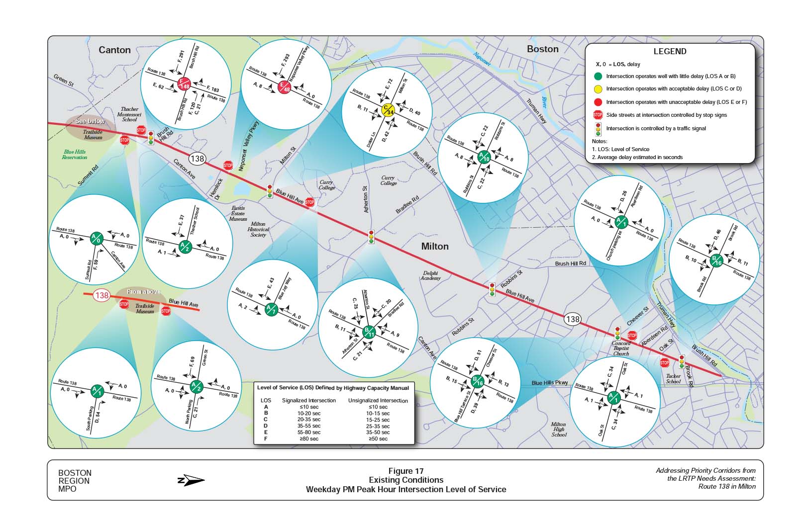
Figure 18
Existing Conditions
Weekend PM Peak Hour Intersection Level of Service
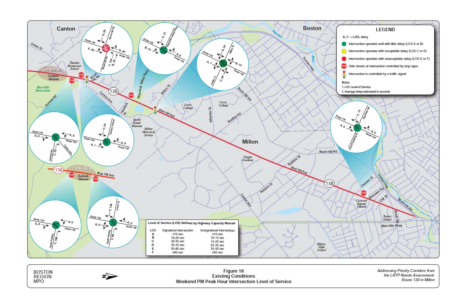
Figure 19
Survey Questions and Number of Respondents
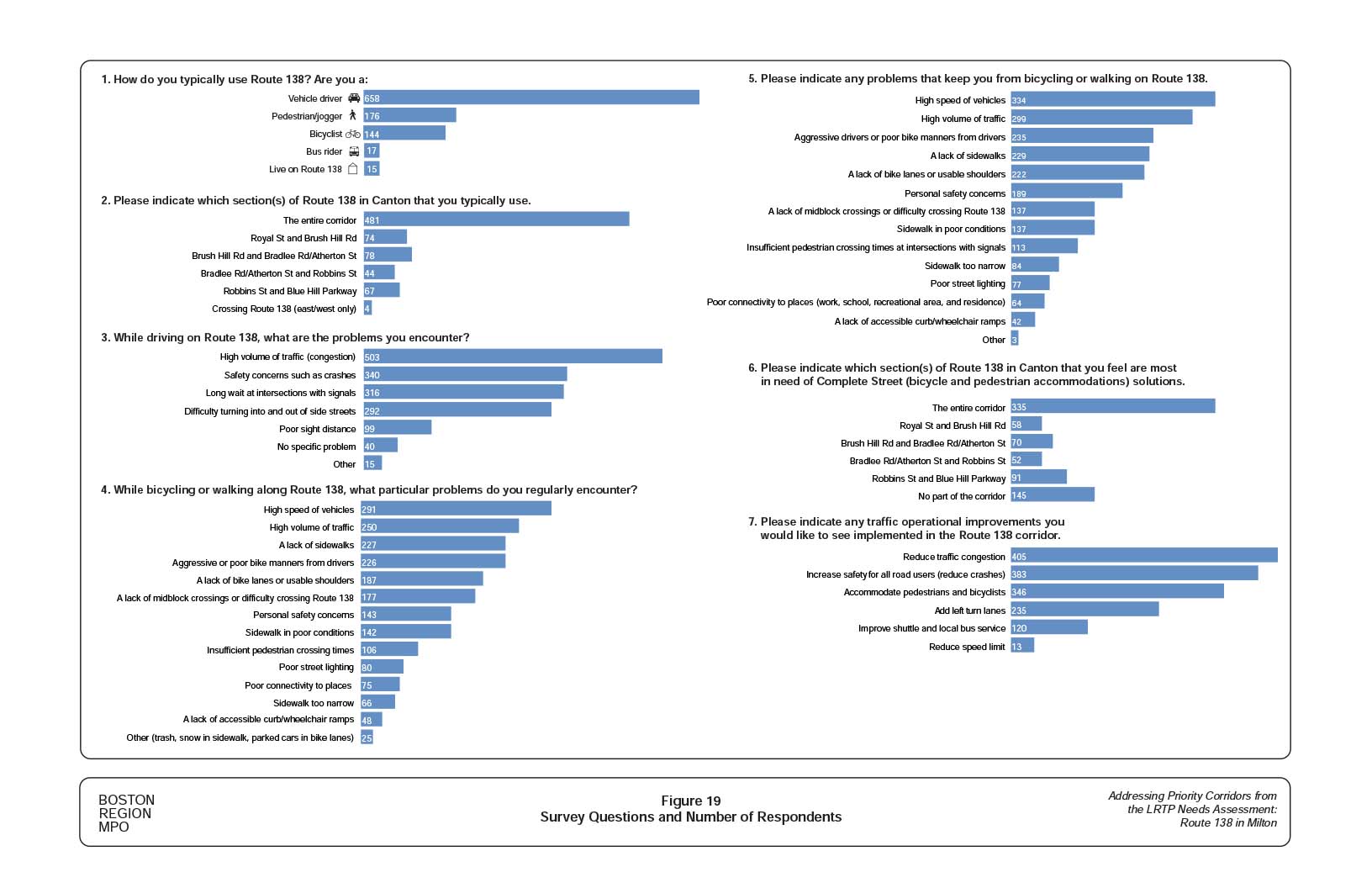
Figure 20
Improvement Concept: Alternative 1- Multi-Use Path on East Side of Roadway: Blue Hills Reservation South Parking Facility Area
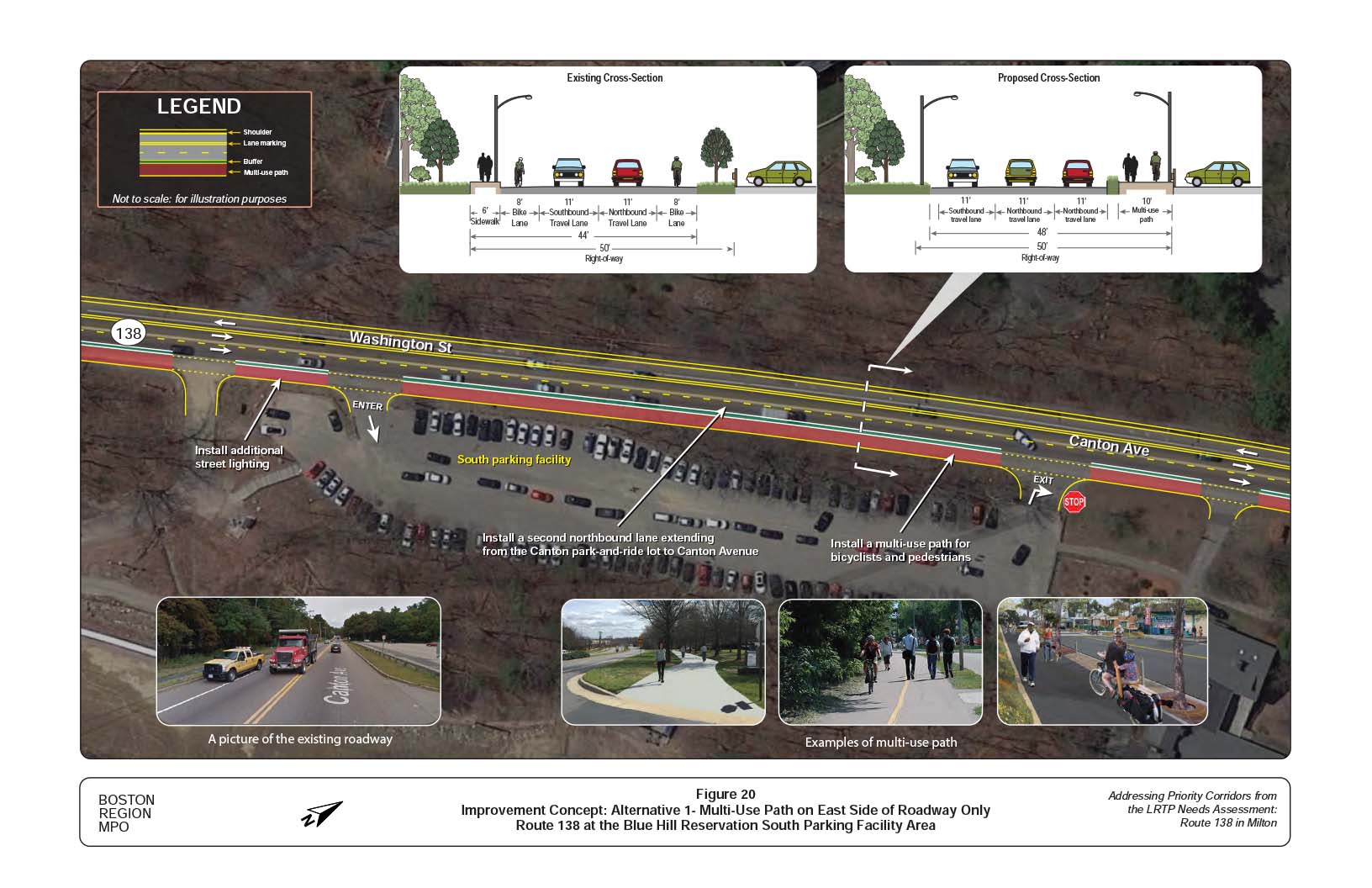
Figure 21
Improvement Concept: Alternative 1 - Multi-Use Path on East Side of Roadway: Green Street to Canton Avenue
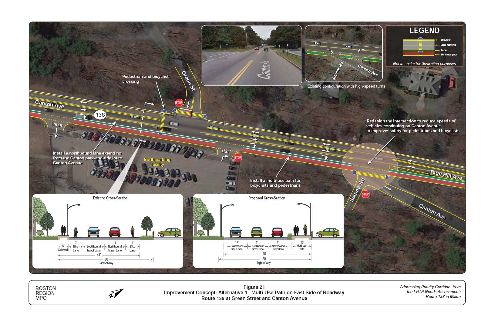
Figure 22
Improvement Concept: Alternative 2 - Dual Bike Lanes and Sidewalks: Blue Hills Reservation South Parking Facility Area
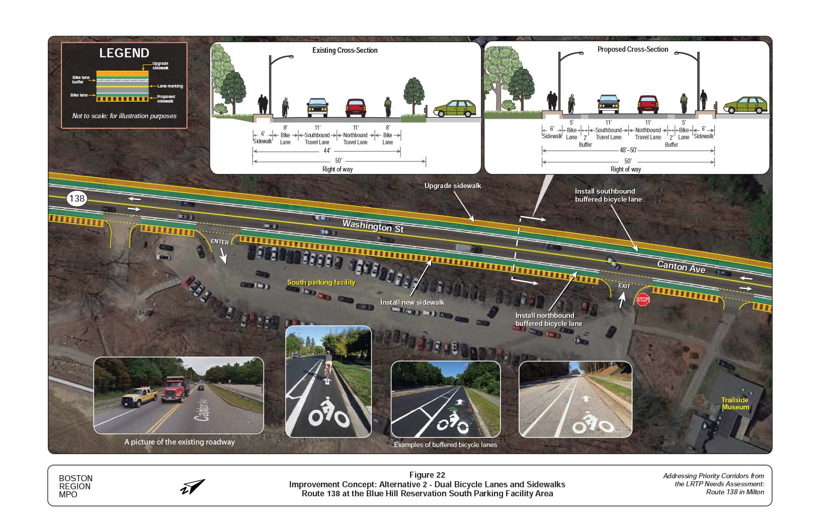
Figure 23
Improvement Concept: Alternative 2 - Dual Bicycle Lanes and Sidewalks: Route 138 at Green Street and Canton Avenue
Figure 24
Improvement Concept: Alternative 1 - Multi-Use Path on East Side of Roadway: Brush Hill Road
Figure 25
Improvement Concept: Alternative 1- Multi-Use Path on East Side of Roadway: Neponset Valley Parkway
Figure 26
Improvement Concept: Alternative 1- Multi-Use Path on East Side of Roadway: Milton Street and Dollar Lane
Figure 27
Improvement Concept: Alternative 1- Multi-Use Path on East Side of Roadway Only: Blue Jay Way (Curry College)
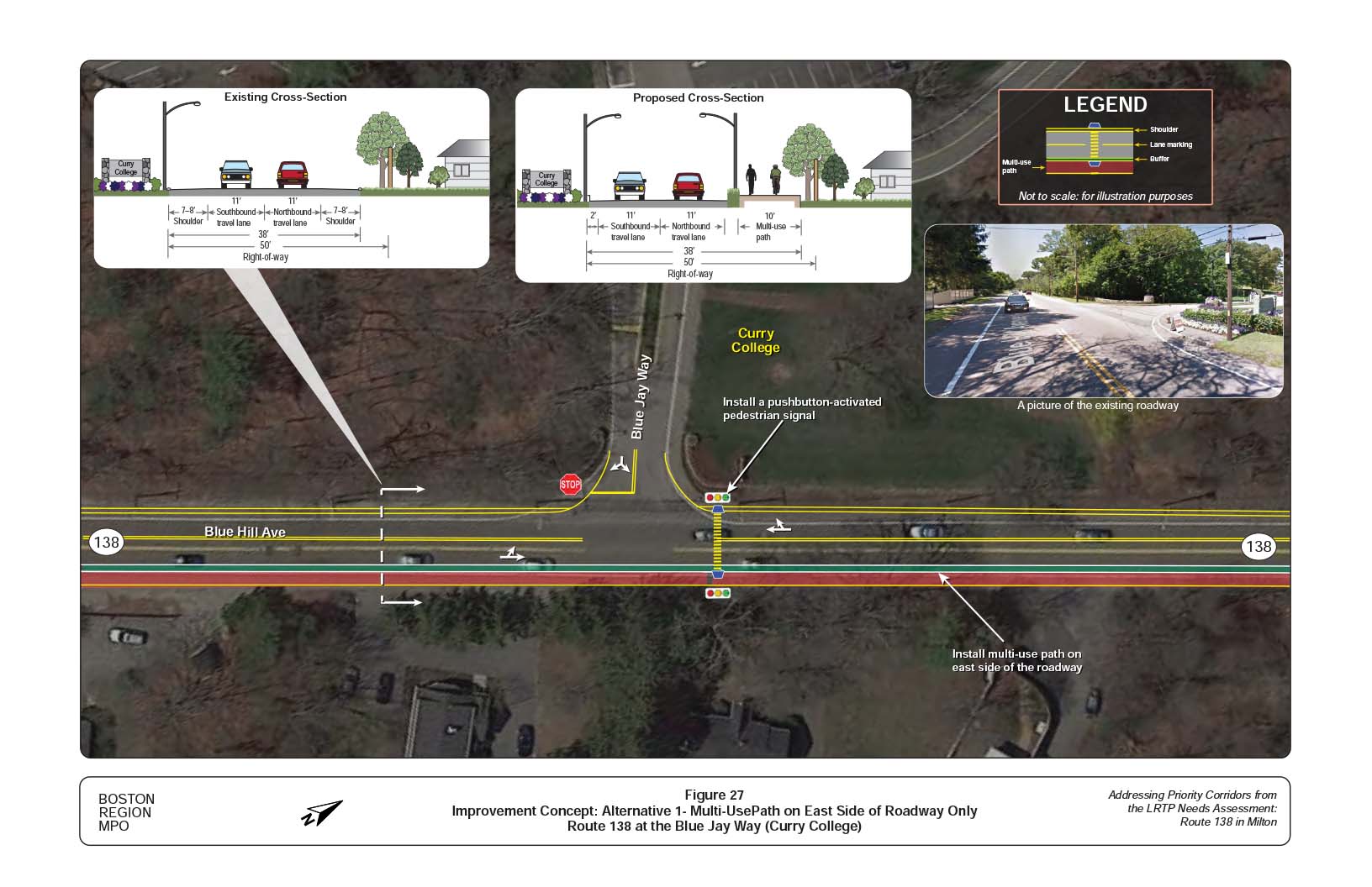
Figure 28
Improvement Concept: Alternative 1- Multi-Use Path on East Side of Roadway Only: Bradlee Road and Atherton Street
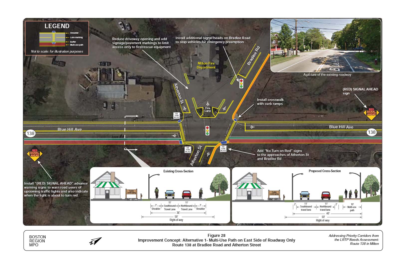
Figure 29
Improvement Concept: Alternative 1 - Two-Way Bicycle Lane on East Side of Roadway: Robbins Street
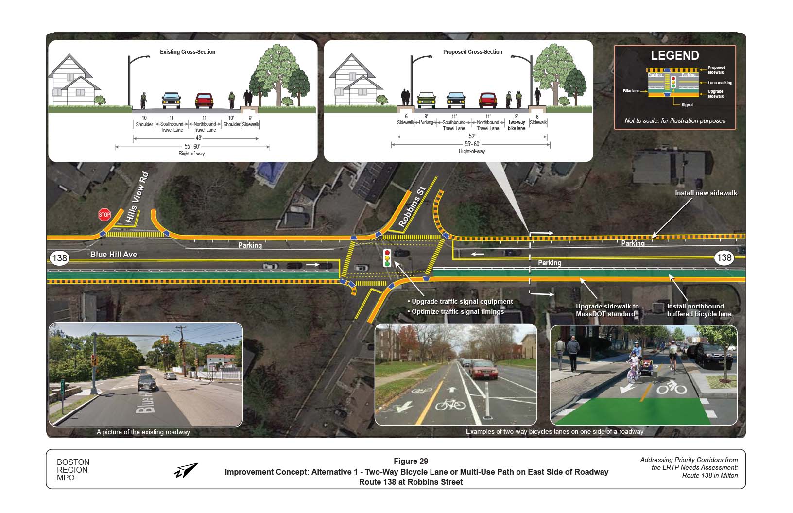
Figure 30
Improvement Concept: Alternative 2 - Dual Bicycle Lanes and Sidewalks: Brush Hill Road
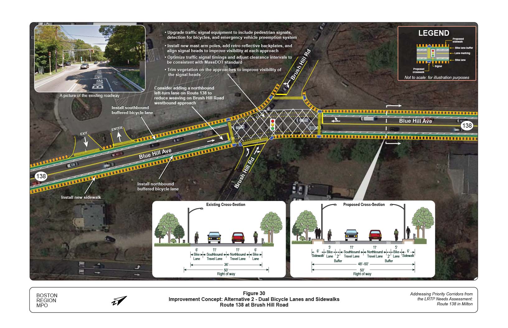
Figure 31
Improvement Concept: Alternative 2: Dual Bicycle Lanes and Sidewalks: Neponset Valley Parkway
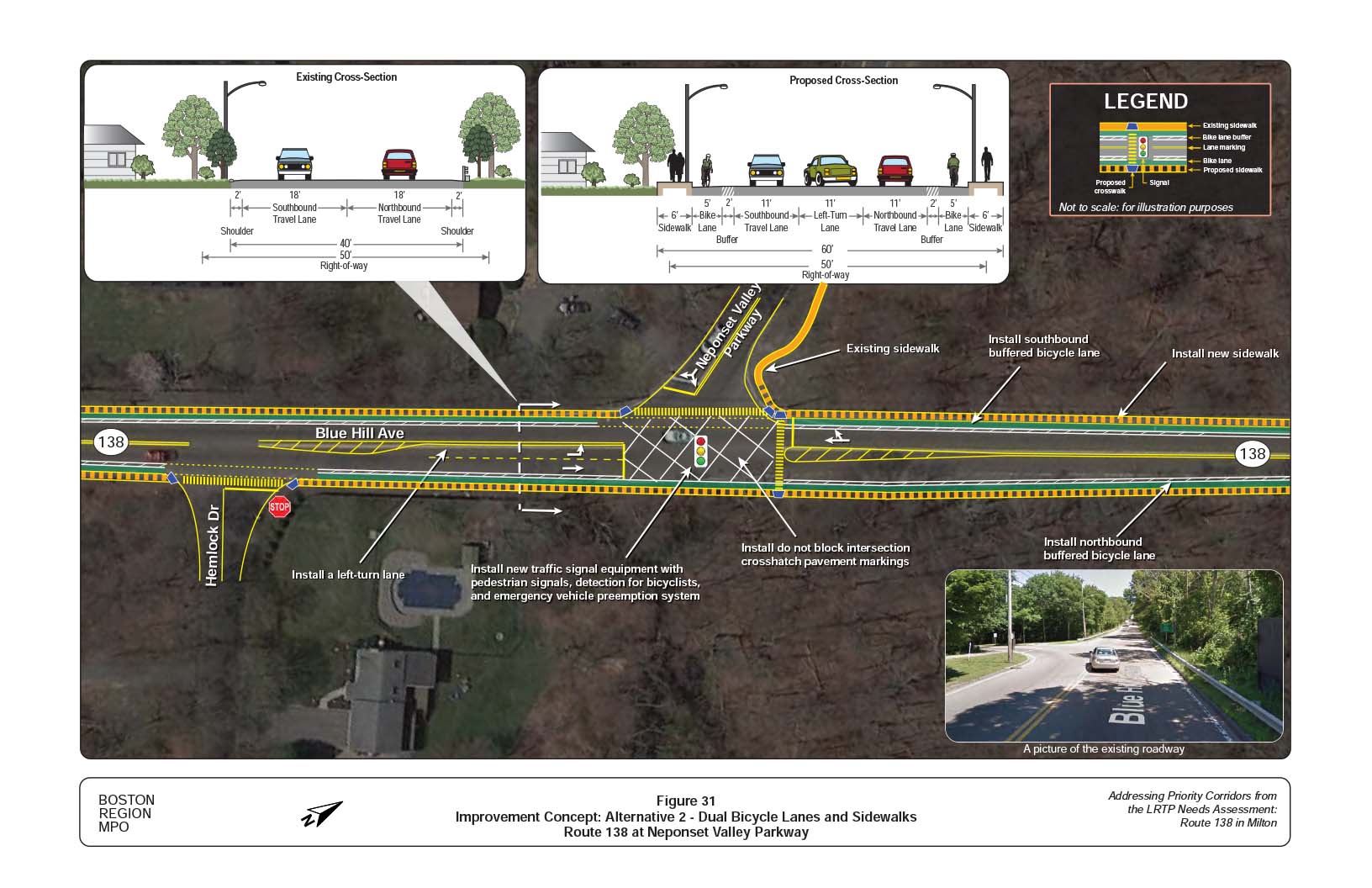
Figure 32
Improvement Concept: Alternative 2 - Dual Bicycle Lanes and Sidewalks: Milton Street and Dollar Lane
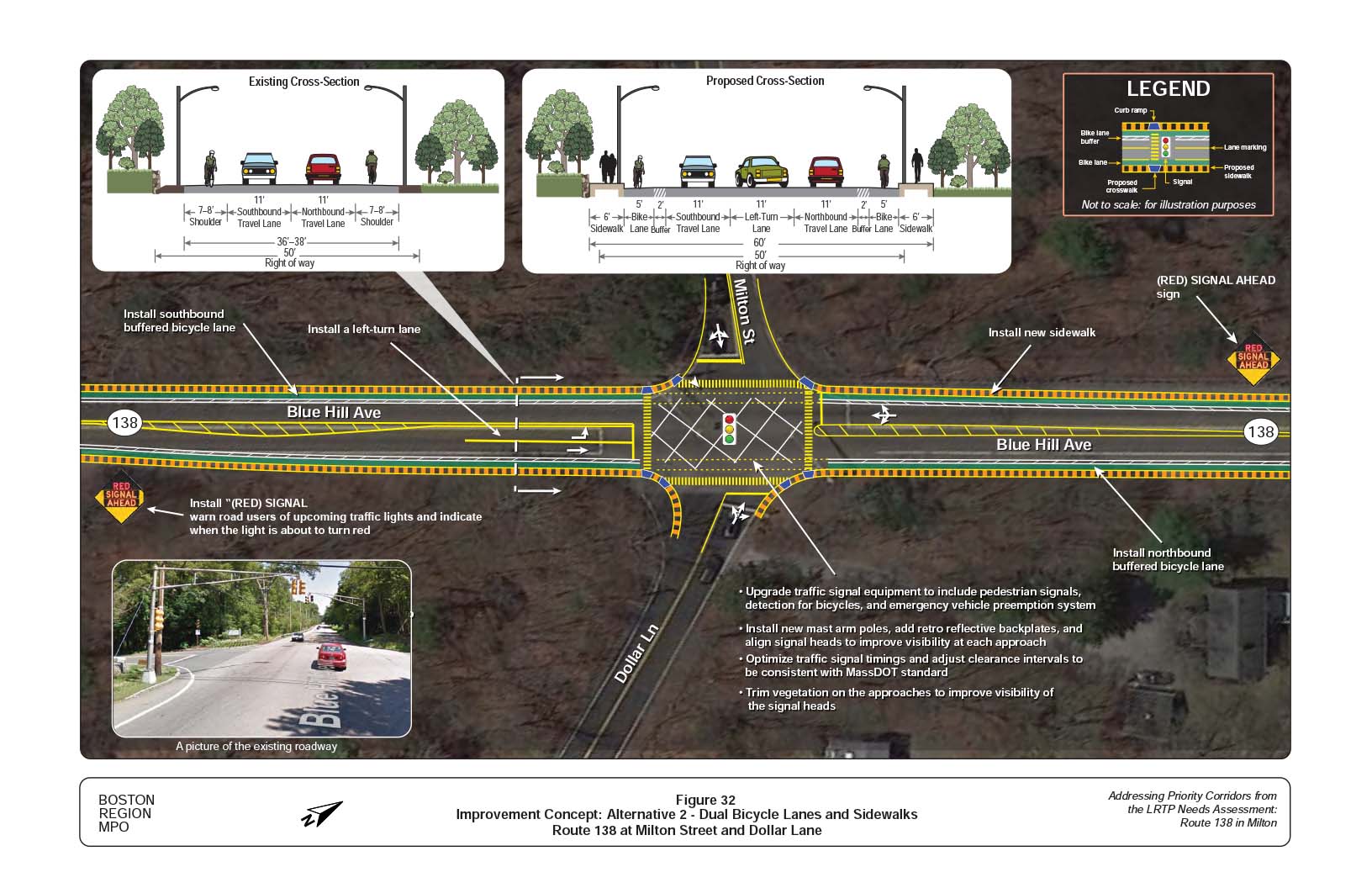
Figure 33
Improvement Concept: Alternative 2 - Dual Bicycle Lanes and Sidewalks: Blue Jay Way (Curry College)
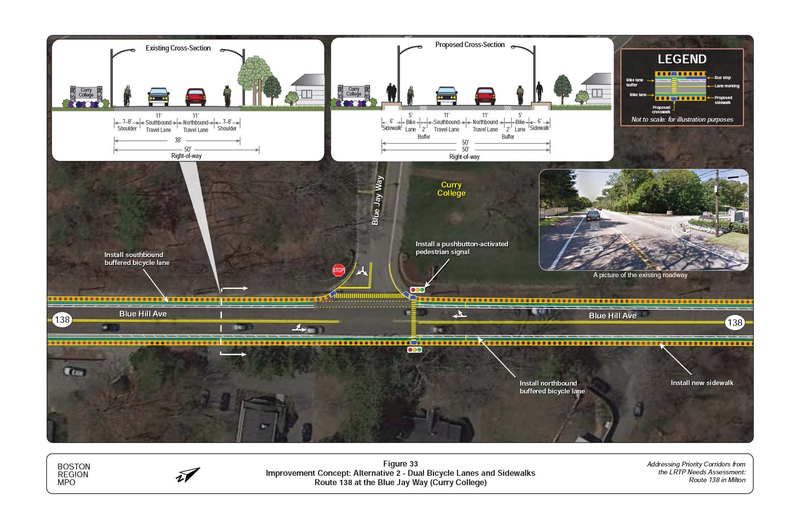
Figure 34
Improvement Concept: Alternative 2 - Dual Bicycle Lanes and Sidewalks: Bradlee Road and Atherton Street
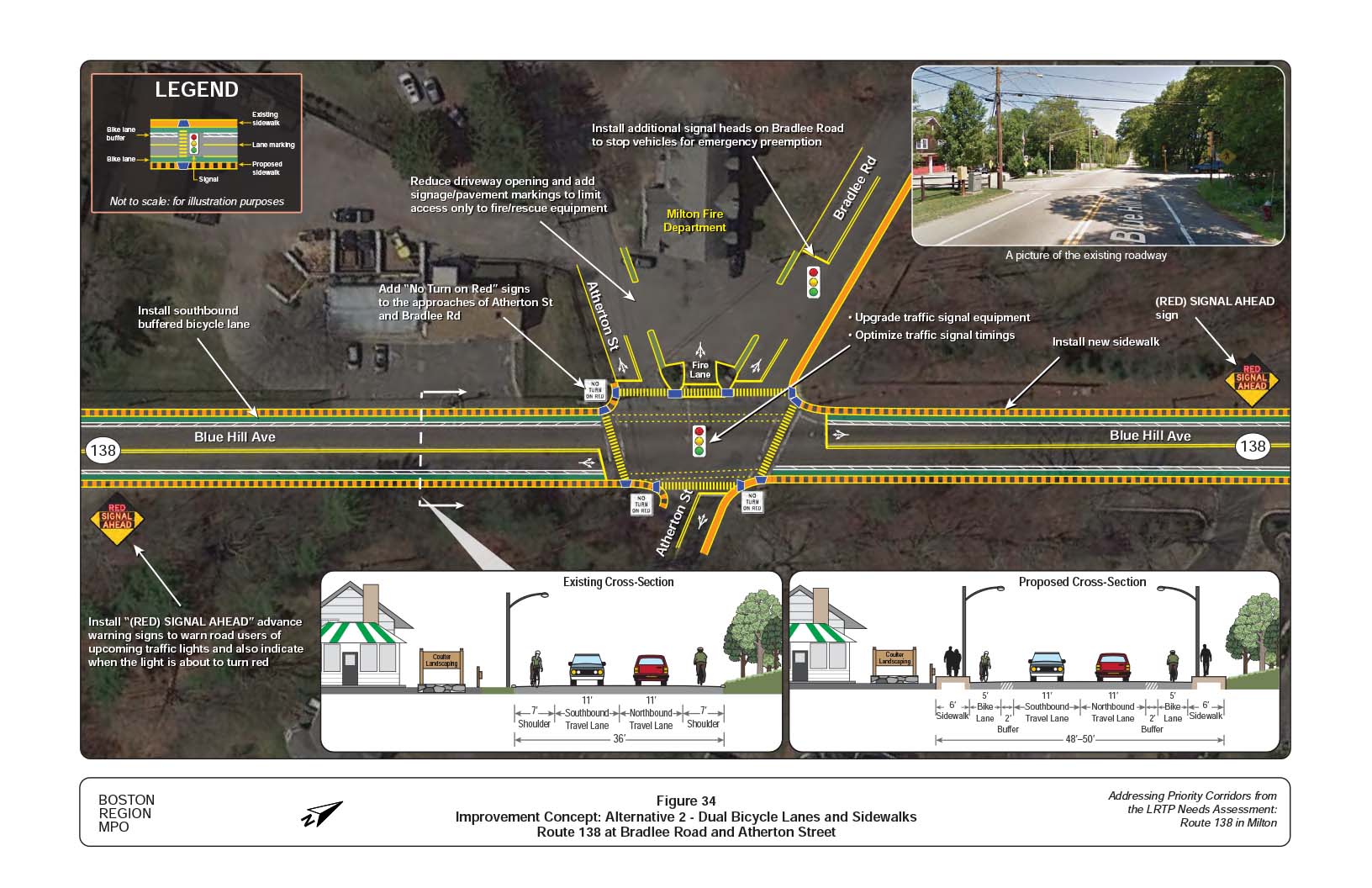
Figure 35
Improvement Concept: Alternative 2 - Dual Bicycle Lanes and Sidewalks: Robbins Street
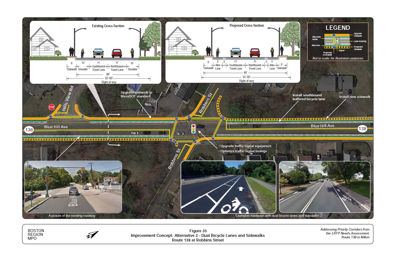
Figure 36
Improvement Concept: Alternative 1- Two-Way Bike Lane on the East Side of the Roadway: Cheever Street and Blue Hill Terrace Street
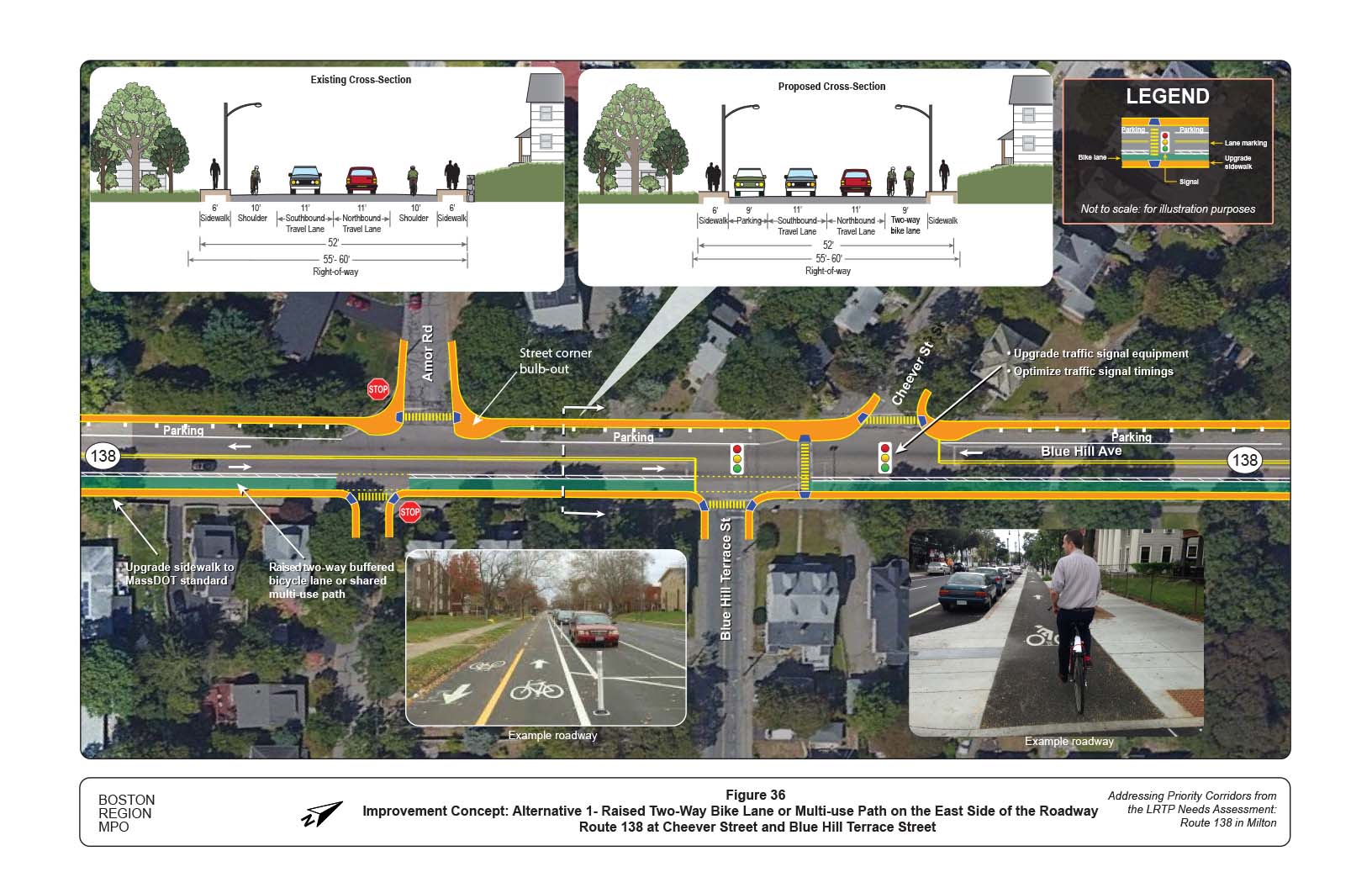
Figure 37
Improvement Concept: Alternative 1 - Two-Way Bicycle Lane on the East Side of Roadway: Aberdeen Road and Oak Street
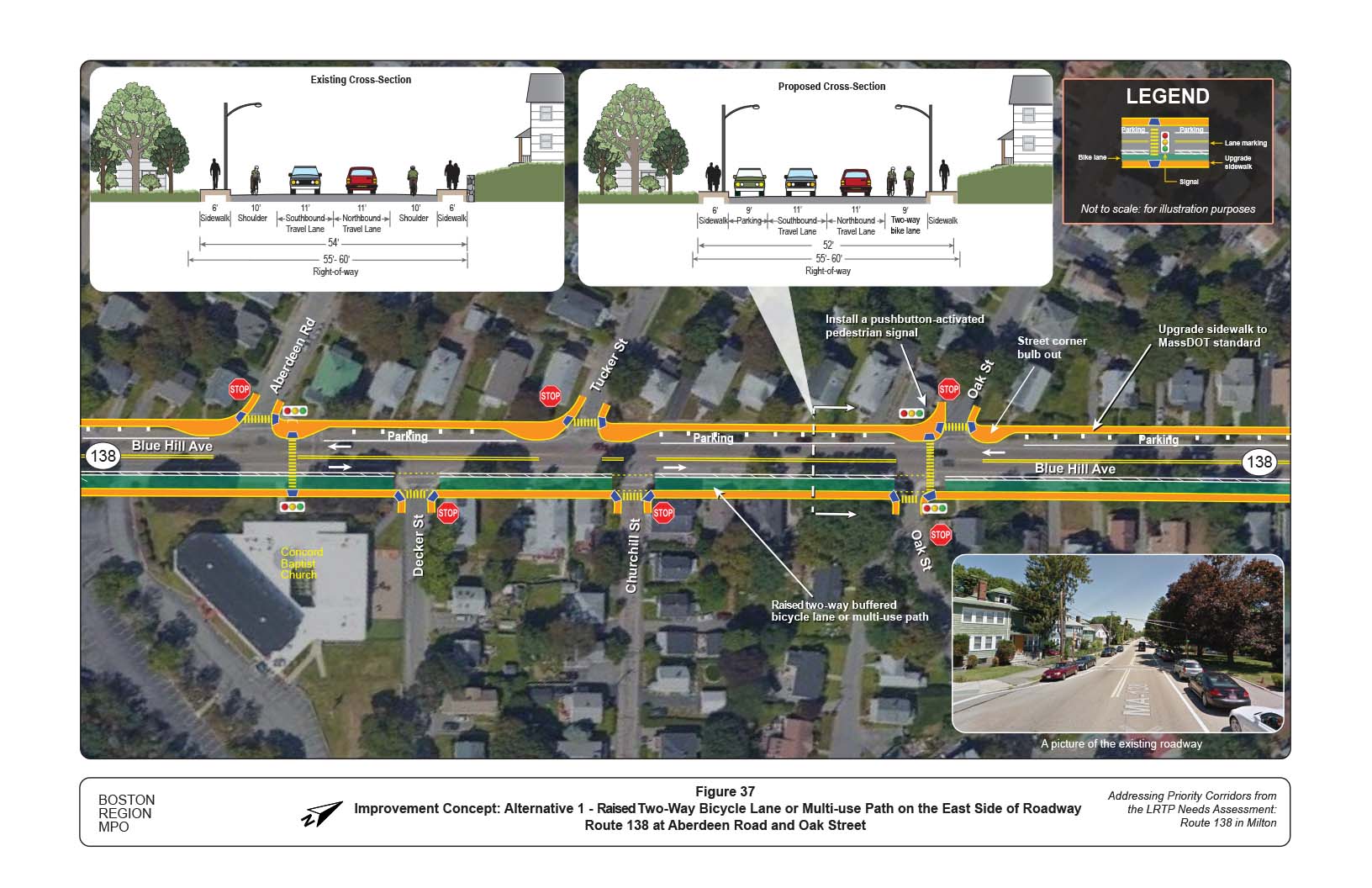
Figure 38
Improvement Concept: Alternative 1: Two-Way Bicycle Lane on East Side of Roadway: Brook Road
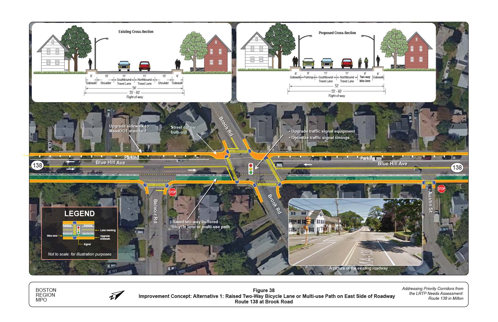
Figure 39
Improvement Concept: Alternative 2 - Dual Bicycle Lanes and Sidewalks: Cheever Street and Blue Hill Terrace Street
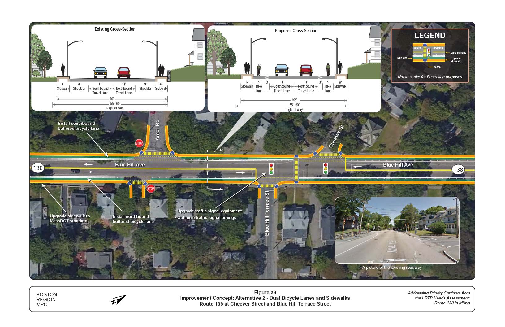
Figure 40
Improvement Concept: Alternative 2 - Dual Bicycle Lanes and Sidewalks: Aberdeen Road and Oak Street
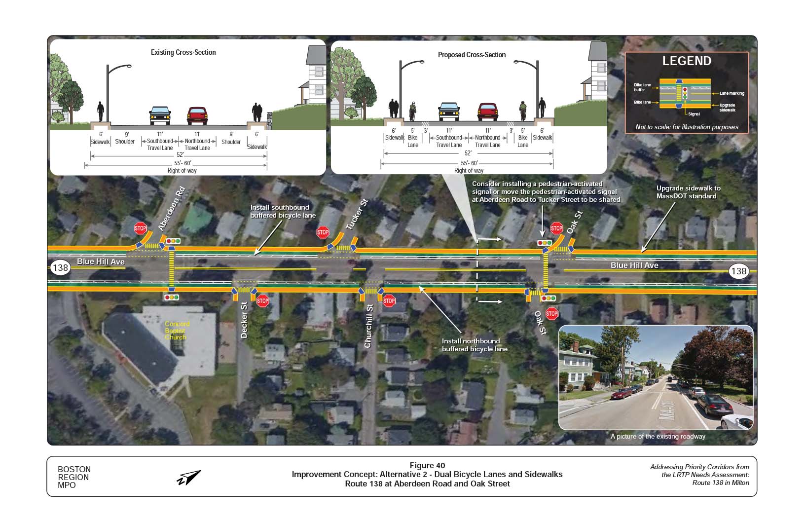
Figure 41
Improvement Concept: Alternative 2 - Dual Bicycle Lanes and Sidewalks: Brook Road
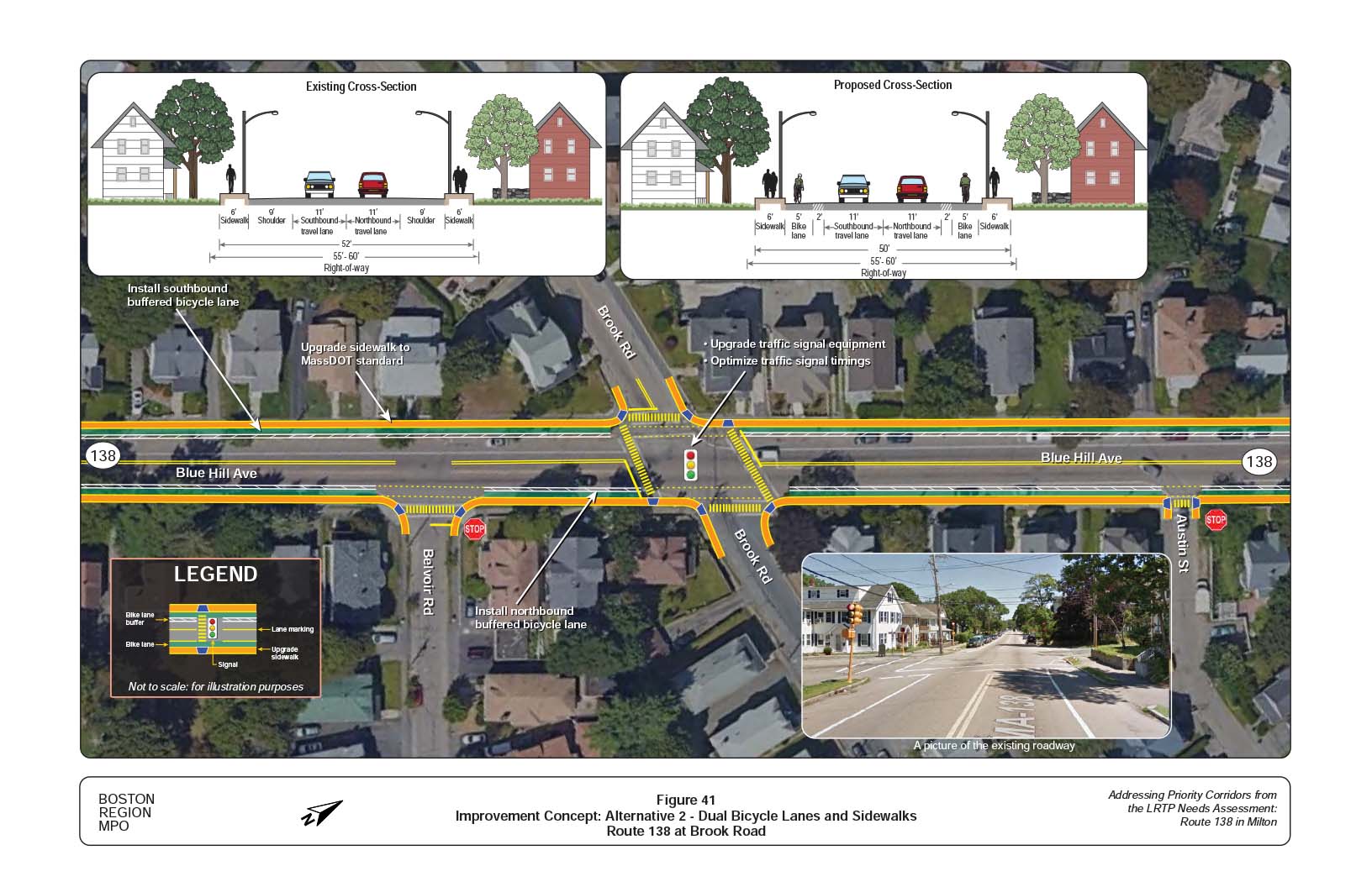
Figure 42
Future Conditions: Weekday AM Peak Hour Intersection Level of Service

Figure 43
Future Conditions: Weekday PM Peak Hour Intersection Level of Service

Figure 44
Future Conditions: Weekend PM Peak Hour Intersection Level of Service