The MPO complies with Title VI of the Civil Rights Act of 1964, the Americans with Disabilities Act (ADA) and other federal and state non-discrimination statutes and regulations in all programs and activities. The MPO does not discriminate on the basis of race, color, national origin, English proficiency, income, religious creed, ancestry, disability, age, gender, sexual orientation, gender identity or expression, or military service. Any person who believes herself/himself or any specific class of persons has been subjected to discrimination prohibited by Title VI, ADA, or other non-discrimination statute or regulation may, herself/himself or via a representative, file a written complaint with the MPO. A complaint must be filed no later than 180 calendar days after the date on which the person believes the discrimination occurred. A complaint form and additional information can be obtained by contacting the MPO (see below) or at www.bostonmpo.org.
For additional copies of this document or to request it in an accessible format, contact:
This document was funded in part through grants from the Federal Highway Administration and Federal Transit Administration of the U.S. Department of Transportation. Its contents do not necessarily reflect the official views or policy of the U.S. DOT.
Decisions about how to spend transportation funds in a metropolitan area are guided by information and ideas from a broad group of people, including elected officials, municipal planners and engineers, transportation advocates, other advocates, and other interested persons. Metropolitan planning organizations (MPOs) are the bodies responsible for providing a forum for this process. Each metropolitan area in the United States with a population of 50,000 or more has an MPO, which decides how to spend federal transportation funds for capital projects and planning studies.
In order to be eligible for federal funds, metropolitan areas are required to maintain a continuing, cooperative, and comprehensive (3C) transportation planning process that results in plans and programs consistent with the planning objectives of the metropolitan area.1 The 3C transportation planning process in the Boston region is the responsibility of the Boston Region Metropolitan Planning Organization (MPO), which has established the following objectives for the process:
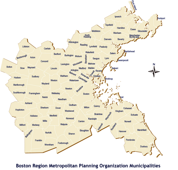
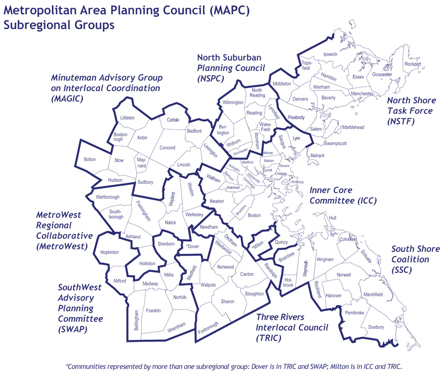
The Boston Region MPO is a 22-member board consisting of state agencies, regional organizations, and municipalities; its jurisdiction extends from Boston to Ipswich on the north, Duxbury on the south, and approximately to Interstate 495 on the west. The 101 cities and towns that make up this area are shown on the map that follows the title page of this document.
As part of its 3C process, the Boston Region MPO annually produces the Transportation Improvement Program (TIP) and the Unified Planning Work Program (UPWP). These documents, along with the Long-Range Transportation Plan (LRTP), are required in order for its process to be certified as meeting federal requirements; this certification is a prerequisite for the receipt of federal transportation funds.
This TIP was developed and approved by the MPO members listed below. The permanent MPO voting members are the Massachusetts Department of Transportation (MassDOT); Metropolitan Area Planning Council (MAPC); MBTA Advisory Board; Massachusetts Bay Transportation Authority (MBTA); Massachusetts Port Authority (Massport); City of Boston, and Regional Transportation Advisory Council. The elected MPO voting members and their respective seats are:
City of Beverly – North Shore Task Force
City of Everett – At-Large City
City of Newton – At-Large City
City of Somerville – Inner Core Committee
City of Woburn – North Suburban Planning Council
Town of Arlington – At-Large Town
Town of Bedford – Minuteman Advisory Group on Interlocal Coordination
Town of Braintree – South Shore Coalition
Town of Framingham – MetroWest Regional Collaborative
Town of Lexington – At-Large Town
Town of Medway – SouthWest Advisory Planning Committee
Town of Norwood – Three Rivers Interlocal Council
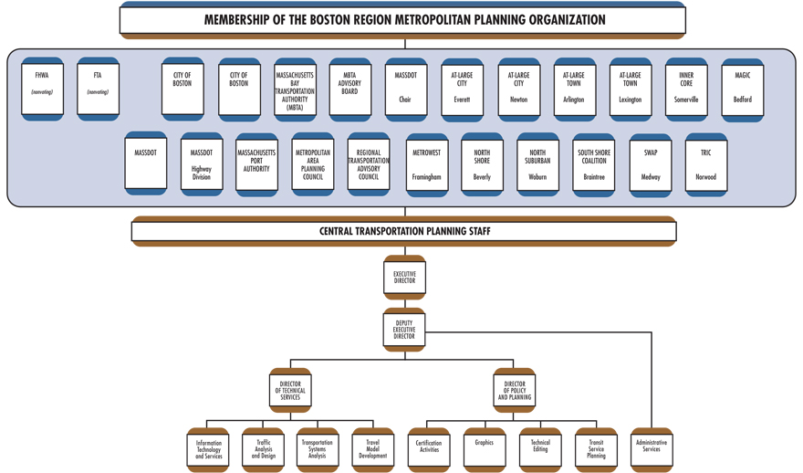
In addition, the Federal Highway Administration (FHWA) and the Federal Transit Administration (FTA) participate in the MPO as advisory (nonvoting) members. The chart on the following page also shows the MPO membership and the organization of the MPO’s staff, the Central Transportation Planning Staff.
Two members participate in the Boston Region MPO in an advisory (nonvoting) capacity, reviewing the Long-Range Regional Transportation Plan (LRTP), the Transportation Improvement Program (TIP), and the Unified Planning Work Program (UPWP) to ensure compliance with federal planning and programming requirements:
Two other entities assist MPO members in carrying out the responsibilities of the MPO’s 3C planning process through policy implementation, technical support, and public participation:
A map of the MAPC Subregional Groups is shown below.
The following section is a brief description of each of the three documents the MPO produces as part of its federally required 3C process:
This legislation requires all MPOs to carry out the 3C process. Activities the MPOs must perform to meet this requirement are:
The MAP-21 legislation establishes national goals for federal highway programs. These goals include:
MAP-21 also establishes performance-based planning as an integral part of the metropolitan planning process. Under MAP-21, states will develop performance goals, guided by the national goals set out in MAP-21, and MPOs will work with state DOTs in developing MPO performance targets. The TIP will integrate the MPO’s performance measures and link transportation investment decisions to progress toward the achievement of performance goals.
The Boston Region Metropolitan Planning Organization (MPO) complies with Title VI of the Civil Rights Act of 1964, the Americans with Disabilities Act (ADA), and other federal and state nondiscrimination statutes and regulations in all programs and activities. The MPO does not discriminate on the basis of race, color, national origin, English proficiency, income, religious creed, ancestry, disability, age, gender, sexual orientation, gender identity or expression, or military service. The major federal requirements are discussed below.
This statute requires that no person be excluded from participation in, be denied the benefits of, or be subjected to discrimination on the basis of race, color, national origin, under any program or activity provided by an agency receiving federal financial assistance.
Executive Order 13166, dated August 11, 2000, extends Title VI protections to persons who, as a result of national origin, have limited English-language proficiency (LEP). Specifically, it calls for improved access to federally conducted and federally assisted programs and activities and requires MPOs to develop and implement a system by which LEP persons can meaningfully participate in the transportation-planning process.
Executive Order 12898, dated February 11, 1994, further expands upon Title VI, requiring each federal agency to achieve environmental justice by identifying and addressing any disproportionately high adverse human health or environmental effects, including interrelated social and economic effects, of its programs, policies, and activities on minority or low-income populations.
On April 15, 1997, the U.S. Department of Transportation issued its Final Order to Address Environmental Justice in Minority Populations and Low-Income Populations. Among other provisions, this order requires programming and planning activities to:
Title III of the Americans with Disabilities Act requires all transportation projects, plans, and programs to be accessible to people with disabilities. At the MPO level, this means that public meetings must be held in accessible buildings and MPO materials must be made available in accessible formats.
Air quality conformity determinations must be performed for capital improvement projects that receive federal funding and for those that are considered regionally significant, regardless of the funding source. These determinations must show that the MPO’s LRTP and TIP will not cause or contribute to any new air quality violations, will not increase the frequency or severity of any existing air quality violations in any area, and will not delay the timely attainment of the air quality standards in any area.
Transportation control measures (TCMs) identified in the State Implementation Plan (SIP) for the attainment of air quality standards are federally enforceable and must be given first priority when using federal funds. Such projects include parking freeze programs in Boston and Cambridge, statewide rideshare programs, rapid transit and commuter rail extension programs, park-and-ride facilities, residential parking sticker programs, and the operation of high-occupancy-vehicle lanes.
The Global Warming Solutions Act (GWSA), which Governor Deval Patrick signed into law in August 2008, makes Massachusetts a leader in setting aggressive and enforceable greenhouse gas (GHG) reduction targets and implementing policies and initiatives to achieve these targets. In keeping with this law, the Massachusetts Executive Office of Energy and Environmental Affairs (EOEEA), in consultation with other state agencies and the public, developed the Massachusetts Clean Energy and Climate Plan for 2020. This implementation plan, released on December 29, 2010, establishes the following targets for overall, statewide GHG emissions:
The transportation sector is the single largest contributor of greenhouse gases, accounting for over a third of GHG emissions, and is therefore a key focus of the Clean Energy and Climate Plan for 2020. MassDOT’s approach to supporting the implementation of the plan is set forth in its GreenDOT Policy Directive, a comprehensive sustainability initiative that sets three principal objectives:
The Commonwealth’s 13 MPOs are integrally involved in helping to achieve the GreenDOT objectives and supporting the GHG reductions mandated under the GWSA. The MPOs seek to achieve these objectives through the prioritization of projects in the LRTP and TIP. The Boston Region MPO’s TIP project evaluation criteria score projects based on greenhouse gas (GHG) emissions impacts, multimodal “complete streets” accommodations, and their ability to support smart-growth development. Tracking and evaluating GHG emissions by project will enable the MPOs to identify the anticipated GHG impacts of the planned and programmed projects and also to use GHG impacts as a criterion in prioritizing transportation investments.
The MPO considered the degree to which a proposed TIP project would advance the policies that guided the development of its LRTP. The MPO also reviewed TIP projects within the context of the recommended projects included in the LRTP.
The MPO aims to implement the recommendations of past studies and reports of the UPWP. This information was considered by the MPO in the development of the draft TIP.
The purpose of the CMP is to monitor transit, roadway, park-and-ride facilities, and bicycle and pedestrian facilities in the MPO region and identify “problem” locations. Projects that help address problems identified in the most recent CMP monitoring were considered for inclusion in this TIP.
In 2009, the MBTA adopted its current PMT, which is the MBTA’s long-range capital plan. The PMT was developed with extensive public involvement and was approved by the MBTA Advisory Board. The PMT includes projects that are currently under design for inclusion in the TIP.
youMove Massachusetts, a statewide initiative designed as a bottom-up approach to transportation planning, developed 10 core themes derived from a broad-based public participation process that articulated the expressed concerns, needs, and aspirations of Massachusetts residents related to their transportation network. These themes formed the basis for the You Move Massachusetts Interim Report (2009), and were considered in the development of this TIP.
weMove Massachusetts (WMM) is MassDOT’s statewide strategic multimodal plan. The initiative is a product of the transportation reform legislation of 2009 and the You Move Massachusetts civic engagement process. WMM will improve how MassDOT does business, responds to customers, and provides transportation services to the commonwealth. Using an analytical approach developed for the WMM process, MassDOT can now prioritize transportation investments for different planning scenarios based on national standards and available funds. The TIP builds on this data-based effort to prioritize transportation investments.
The Healthy Transportation Compact (HTC) is a key requirement of the Massachusetts landmark transportation reform legislation that took effect on November 1, 2009. It is an interagency initiative that will help ensure that the transportation decisions the Commonwealth makes balance the needs of all transportation users, expand mobility, improve public health, support a cleaner environment, and create stronger communities.
The agencies work together to achieve positive health outcomes through the coordination of land use, transportation, and public health policy. HTC membership is made up of the Secretary of Transportation or designee (co-chair), the Secretary of Health and Human Services or designee (co-chair), the Secretary of Energy and Environmental Affairs or designee, the Administrator of Transportation for Highways or designee, the Administrator of Transportation for Mass Transit or designee, and the Commissioner of Public Health or designee.
The HTC also promotes improved coordination among the public sector, private sector, and advocacy groups, as well as among transportation, land-use, and public health stakeholders. As part of the framework for the HTC, MassDOT established a Healthy Transportation Advisory Group comprising advocates and leaders in the fields of land-use, transportation, and public health policy.
The $3 billion Patrick-Murray Accelerated Bridge Program (ABP) represents a monumental investment in Massachusetts bridges. This program will greatly reduce the number of structurally deficient bridges in the state system, while creating thousands of construction jobs on bridge projects.
To complete this program, MassDOT and the Department of Conservation and Recreation (DCR) have relied on the use of innovative and accelerated project development and construction techniques. As a result, projects have been completed on time, on budget, and with minimum disruption to people and to commerce.
Since 2008, the number of former structurally deficient bridges has dropped, from 543 to 436, a decline of 19.7 percent. As of January 1, 2013, the ABP Program has completed 121 bridge projects, with another 48 bridge projects currently in construction and an additional 20 bridge projects scheduled to start construction within the next year. Over the course of the eight-year ABP program, it is expected that more than 200 bridges will be replaced or repaired.
In the fall of 2012, MassDOT announced a statewide mode shift goal of tripling the share of travel in Massachusetts that uses the modes of bicycling, transit, and walking. The mode shift goal aims to foster improved quality of life by improving our environment and preserving the capacity on our highway network. In addition, positive public health outcomes will be achieved by providing more healthy transportation options.
In choosing projects for inclusion in the TIP, the Boston Region MPO considers the degree to which a project forwards the following MPO policies, which were adopted in April 2010, and are the basis for the TIP evaluation process:
Maximizing efficiency, reliability, mobility, and accessibility with our existing infrastructure and within current and ongoing fiscal constraints will require following a program of strategic, needs-based investments. To accomplish this, the MPO will put a priority on programs, services, and projects that:
To make livability a hallmark of communities in the MPO region and to achieve mobility, foster sustainable communities, and expand economic opportunities and prosperity, the MPO will put a priority on programs, services, and projects that:
To improve mobility for people and freight, the MPO will put a priority on programs, services, and projects that:
To protect the environment and minimize the impacts from transportation systems, the MPO will put a priority on programs, services, and projects that:
To provide for the equitable sharing of the benefits and burdens of transportation investments among all residents of the region, the MPO will put a priority on programs, services, and projects that:
To meet the targets for reducing GHG emissions, the MPO will put a priority on programs, services, and projects that:
To provide for maximum transportation safety and to support security in the region, the MPO will put a priority on programs, services, and projects that:
Among the most important decisions faced in planning for the future are those involving how to spend scarce funds to achieve the best transportation value. Transportation is part of the solution to many critical regional, state, national, and even global problems, such as traffic congestion, air pollution, traffic fatalities and injuries, climate change, and environmental justice. With not nearly enough transportation funding available to build all of the needed and worthy projects to address these problems, investments should be guided by policies that help identify the strongest solutions. The TIP seeks to prioritize these transportation investments through its annual development process.
Each year, the MPO conducts a TIP development process to decide how to spend federal transportation funds for capital projects. The Central Transportation Planning Staff to the Boston Region MPO manages the annual development process for the TIP. The MPO staff coordinates the evaluation of project requests, propose programming of current and new projects based on anticipated funding levels, support the MPO in the development a draft document, and facilitate public review of the draft document before the final MPO endorsement.
The first step in the process of allocating federal transportation funds is for a multiyear transportation authorization act to establish a maximum level of federal transportation funding per federal fiscal year. The establishment of this level of funding is referred to as an authorization. The most recent authorization act is Moving Ahead for Progress in the 21st Century (MAP-21), signed into law on July 6, 2012.
Once the authorization level has been established, the United States Department of Transportation annually allocates funding among the states, based on various federal formulas. This allocation is referred to as an apportionment. The annual apportionment rarely represents the actual amount of federal funds that is committed to a state, due to federally imposed limitations on spending in a given fiscal year called obligation authority.
Obligation authority may be imposed in a multiyear authorization act, in the annual appropriations act, or in both. Obligation authority is typically less than a state’s apportionment. In Massachusetts, TIPs are developed based on the estimated obligation authority.
Two of the most important distinctions between apportionment and obligation authority are: (1) apportionment is allocated on a per-program basis, while obligation authority is generally allocated as a lump sum; and (2) unused apportionment carries forward into successive federal fiscal years (FFYs), but unused obligation authority does not. Unused apportionment that is carried forward is referred to as an unobligated balance. Although a state’s unobligated balance can be used to increase the federal aid programmed within a particular funding category in a given FFY, it cannot be used to increase the total amount of the state’s highway apportionment.
Federal regulations require states to “provide MPOs with estimates of Federal and State funds which the MPOs shall utilize in developing financial plans” for TIPs. 3 The FFYs 2014–17 TIP was developed under the assumption that the Statewide Federal Highway Program would be $600 million annually over the next four years. In Massachusetts, federal highway program funding is allocated to several major funding categories. First, MassDOT allocates federal funding to Grant Anticipation Notes (GANs) payments for the Central Artery/Tunnel project in FFY 2014 and the Accelerated Bridge Program in FFYs 2015–17. Over the four years of this TIP, approximately $122.8 million of the Highway Program is dedicated to GANs payments for the Central Artery/Tunnel project and $450 million in federal aid is dedicated to GANs payments for the Accelerated Bridge Program. MassDOT matches the remaining amount of federal funding at an 80 percent (federal) and 20 percent (state) split. Next, funding is allocated to the following funding categories prioritized by MassDOT:
After these needs are satisfied, the remaining federal funding is allocated to the state’s MPOs for programming. This discretionary funding for MPOs is suballocated by formula to determine “regional target” amounts. These targets are developed in consultation with the Massachusetts Association of Regional Planning Agencies. Each MPO can decide how the Regional Target funding is prioritized. Over the next four years, the Boston Region MPO’s total Regional Target Program is approximately $296.8 million, or on average $74.1 million annually. To decide how to spend its Regional Target, the Boston Region MPO engages its 101 cities and towns in an annual development process for this decision making.
The Federal Transit Program is allocated within the Boston Urbanized Area (UZA) by formula to the transit operators. The formula considers passenger-miles, population density, and other factors associated with each transit provider. There are three regional transit authorities (RTAs) in the Boston MPO region: the Massachusetts Bay Transportation Authority (MBTA), the MetroWest Regional Transit Authority (MWRTA), and the Cape Ann Transportation Authority (CATA). The MBTA, with its extensive transit program and infrastructure, is the recipient of the preponderance of federal transit funds in the region.
Many federal-aid transportation programs support transportation activities in metropolitan areas, each having different requirements and program characteristics. Non-federal aid (state funds) for the Statewide Infrastructure Items, Bridge Program, and Central Artery/Tunnel project, is derived from various sources, including the Commonwealth’s Transportation Bond Bill. Under MAP-21, federal programs that fund projects in the FFYs 2014–17 TIP are listed in the following two tables.
TABLE 2-1
Federal Transit Administration Programs
MAP-21 Program |
Eligible Uses |
Examples |
|---|---|---|
Urbanized Area Formula Grants (Section 5307) |
Transit capital and operating assistance in urbanized areas. Under MAP-21, job access and reverse-commute activities (formerly funded under Section 5316) are now eligible for funding under Section 5307. |
Red/Orange Lines – New Vehicle Procurement (MBTA Revenue Vehicles) – FFYs 2014–17 |
Fixed Guideway/Bus (Section 5337) [Replaces the Fixed Guideway Modernization Program (Section 5309)] |
Replacement, rehabilitation, and other state-of-good-repair capital projects. |
Red Line Floating Slab (MBTA Track/Right-of-Way Program) – FFY 2014 |
Bus and Bus Facilities (Section 5339) |
Capital projects to replace, rehabilitate, and purchase buses and related equipment, and to construct bus-related facilities. |
MBTA Systems Upgrades Program – FFYs 2014–17 |
Enhanced Mobility of Seniors and Individuals with Disabilities (Section 5310) |
Capital expenses that support transportation to meet the special needs of older adults and persons with disabilities. Under MAP-21, New Freedom program (Section 5317) activities are now eligible under Section 5310. |
Coordination of Non-Emergency Human Service Transportation (Mystic Valley Elder Services) – FFY 2014 |
TABLE 2-2
Federal Highway Administration Programs
MAP-21 Program |
Eligible Uses |
Examples |
|---|---|---|
Congestion Mitigation and Air Quality Improvement (CMAQ) |
A wide range of projects in air quality nonattainment and maintenance areas for ozone, carbon monoxide, and small particulate matter that reduce transportation-related emissions. |
Lebanon Street (Melrose) – FFY 2014 |
Highway Safety Improvement Program (HSIP) |
Implementation of infrastructure-related highway safety improvements |
Route 2/Crosby’s Corner (Concord & Lincoln) – FFY 2014 |
National Highway Performance Program (NHPP) [Replaces the National Highway System (NHS) and Interstate Maintenance (IM) Programs, and a portion of the Bridge Program] |
Improvements to interstate routes, major urban and rural arterials, connectors to major intermodal facilities, and the national defense network. Also includes replacement or rehabilitation of any public bridge, and resurfacing, restoring, and rehabilitating routes on the interstate highway system. |
Route 128 Improvement Program (Needham & Wellesley) – FFYs 2014–17 Washington Avenue Bridge Replacement (Chelsea) – FFY 2014 |
Surface Transportation Program (STP) [Replaces a portion of the Bridge Program] |
A broad range of surface transportation capital needs, including many roads; transit, sea, and airport access; and vanpool, bicycle, and pedestrian facilities. |
Rantoul Street/Route 1A (Beverly) – FFY 2014 |
Transportation Alternatives Program (TAP) [Replaces the Transportation Enhancements, Recreational Trails, and Safe Routes to School Programs] |
Construction of infrastructure-related projects (e.g., sidewalk, crossing, and on-road bicycle facility improvements). Under MAP-21, Safe Routes to School and Recreational Trails projects are now eligible under TAP. |
Downey Elementary School (Westwood) – FFY 2014 |
High-Priority Projects (HPP) [Carryover from SAFETEA-LU] |
Named projects for which funds are specifically identified from previous authorizations. |
Gainsborough & St. Botoloph Sts. (Boston) – FFY 2014 |
Discretionary Funding |
Specific projects in annual appropriations funded through grant programs such as Transportation, Community and System Preservation Program, Value Pricing Pilot Program, and Transportation Infrastructure Finance and Innovation Act Program. |
|
The MPO’s project selection process for its highway discretionary (“regional target”) funding uses evaluation criteria to help identify and prioritize projects that advance the MPO’s goals. The criteria are based on the MPO’s visions and policies that were adopted for its Long-Range Transportation Plan, Paths to a Sustainable Region.
All projects are required to show consistency with the Long-Range Transportation Plan and other statewide and regional plans (for example, the Program for Mass Transportation and the Massachusetts Statewide Bicycle Transportation Plan).
The MPO staff evaluates each project that is considered for inclusion in the TIP based on the specific criteria that have been developed by the MPO. Other inputs include project readiness and municipal support. Additional background information on the TIP project evaluation process is provided in Appendix B of this document and on the MPO’s website, http://bostonmpo.org/Drupal/tip. The MPO reviews the effectiveness of this evaluation method and makes alterations to the process as appropriate.
The outreach process begins early in the fiscal year, when the MPO staff begins to brief local officials and members of the public on the year’s development process. In December, the MPO staff solicits a listing of priority projects to be considered for federal funding from each of the 101 cities and towns in the region. The MPO also seeks the input from interested parties and members of the general public. The staff then compiles the project funding requests and relevant information into a Universe of Projects list for the MPO. The Universe of Projects list consists of all identified projects being advanced for possible funding and includes projects in varied stages of development, from being in the conceptual stage to being fully designed and ready to be advertised for construction.
New projects must be initiated through the MassDOT Highway Division before they can be considered for programming in the TIP. Details of the project initiation process and relevant documents can be found on the Project Review Committee webpage, http://www.mhd.state.ma.us/default.asp?pgid=content/projectReview&sid=about. Municipal TIP Contacts and the MPO staff coordinate to update each project´s Project Funding Application Form through the MPO´s Interactive TIP Database, http://www.bostonmpo.org/apps/tip9/tip_query.html. The form provides information on each project´s background, infrastructure condition and needs, development status, and ability to help the region attain the visions established by the MPO.
More information on the Project Funding Application Forms can be found in Appendix B of this document.
The MPO has begun to monitor the anticipated greenhouse gas (GHG) emission impacts of planned and programmed projects. This tracking will enable the MPO to consider the anticipated impacts when prioritizing transportation investments. More information on the GHG emission monitoring and evaluation can be found in Appendix C of this document.
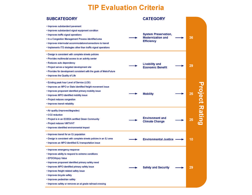
The MPO uses TIP project evaluation criteria to develop a numeric score that gives an indication of how well each project helps the region attain the visions established by the MPO. This score can then be used to guide the MPO in selecting the projects that will be most successful. The MPO’s visions include: to maintain a state of good repair, focus investments on existing activity centers, improve mobility for people and freight, reduce the level of greenhouse gas (GHG) emissions, minimize environmental burdens from transportation facilities on low-income and minority populations, and provide safe transportation for all modes. Projects with components and outcomes that help attain the goals of the MPO receive higher scores.
The project evaluation criteria consist of 35 questions across six policy categories. The TIP evaluation criteria graphic on page 2-7 provides an overview of the policy categories, their point values, and the criteria measures.
The MPO staff requires a Functional Design Report (FDR) to conduct a complete evaluation (see MassDOT’s Project Development and Design Guide for information about what is included in a Functional Design Report). If not enough information is available, a project cannot be fully evaluated across all categories.
The summary of evaluation results for projects being considered for the federal fiscal years (FFYs) 2014–17 TIP is available in table A-1 of Appendix A. The table contains the total project rating for each project. For more details on the evaluation criteria used to score projects, see Appendix B.
The MPO staff uses evaluations and project readiness information to prepare a First-Tier List of Projects. This is a list of the projects with the highest ratings that could be made ready for advertising within the TIP’s time horizon (the next four federal fiscal years). The staff relies on the MassDOT Highway Division to provide information about what year a project would be ready for advertising. In developing the staff recommendation for the draft TIP, the MPO staff strongly considers the First-Tier List of Projects. The MPO staff also factors in projects that are listed in the Long-Range Transportation Plan (LRTP) in order to implement the LRTP, considers geographic equity to help ensure that the list of projects addresses needs throughout the region, and accounts for cost to comply with fiscal constraint.
The project selection criteria for the Bridge Program are based on a continuous, ongoing prioritization process of MassDOT. The underlying basis for this prioritization is the condition of the bridges based largely on information gathered through the Bridge Inspection Management System.
The project selection process for the Statewide Infrastructure Items involves coordination between the MassDOT divisions to review and prioritize projects that advance important statewide policy goals for improving mobility, protecting the environment, promoting economic growth, and improving public health and quality of life. Other prioritization factors include project readiness and consistency with MassDOT’s GreenDOT sustainability policy, the Bay State Greenway Priority 100, and the Safe Routes to School Program.
The process of selecting transit projects for the TIP draws primarily from the Massachusetts Bay Transportation Authority (MBTA) Capital Investment Program (CIP). The CIP is a rolling five-year plan that outlines the transit system´s infrastructure needs and planned investments within that short-range time frame. The MBTA updates the CIP annually. Prioritization of projects for inclusion in the CIP is based on their impacts on the following, as defined in the MBTA’s enabling legislation: the effectiveness of the commonwealth’s transportation system; service quality; the environment, health, and safety; the state of good repair of MBTA infrastructure; and the MBTA’s operating costs and debt service.
Projects that receive the highest priority are those with the greatest benefit and the least cost, as prioritized by the following criteria:
The transit element of the TIP also includes the federal-aid programs of the other two transit authorities in the region, the Cape Ann Transportation Authority (CATA) and MetroWest Regional Transit Authority (MWRTA). CATA and MWRTA coordinate with the MassDOT Rail and Transit Division to develop their capital programs.
The MPO considers the evaluation results, First-Tier List of Projects, and staff recommendation in prioritizing projects for Regional Target funding. They also consider public input, regional importance, and other factors in the development of the draft TIP. In addition to prioritizing the Regional Target funding, the MPO also reviews the Statewide Infrastructure Items and Bridge Programs, and the capital programs for the MBTA, CATA, and MWRTA, before voting to release a draft TIP for public review.
This year, the MPO voted in early May to release the draft federal fiscal years (FFYs) 2014–17 TIP for a 30-day public review and comment period. The MPO invites members of the public, regional and local officials, and other stakeholders from the Boston region to review the proposed program. Several TIP outreach sessions are held during the public comment period to solicit comments on the draft TIP. Summaries of comments received on the draft TIP are provided in Appendix F.
After the comment period ends, the MPO reviews all comments and makes changes to the document as appropriate. This year the MPO is scheduled to take action on the draft FFYs 2014–2017 TIP on June 27, 2013. Once the TIP is endorsed by the MPO, it is incorporated into the State Transportation Improvement Program (STIP) and sent to the Federal Highway Administration and Federal Transit Administration to enable federal approval by September 30, the end of the federal fiscal year.
The TIP is a dynamic program that is amended and adjusted throughout the year. Administrative modifications and amendments often must be introduced due to changes in project status, project cost, or available revenues.
Consistent with federal guidelines, if a project is valued at $5 million or less, the threshold for defining an amendment is a change of $500,000 or more. The threshold for projects valued at greater than $5 million is 10 percent or more of the project value. Changes below these thresholds may be considered administrative modifications. The MPO acts on administrative modifications, and, although no public review period is required, one may be provided at the MPO’s discretion.
Affected municipalities and constituencies are notified of pending amendments. Legal notices of amendments are placed in the region’s major newspaper, in its most widely read minority newspaper and Spanish-language newspaper, and on the MPO’s website. In addition, a notice of a pending amendment is distributed to the MPO’s email listserv, MPOinfo, and, along with the actual amendment, is posted on its website. These notices include information on a 30-day public comment period that precedes MPO action on the amendment. The Regional Transportation Advisory Council is notified and briefed during this period and provides its comments. Municipal representatives and members of the public may also submit written or oral testimony at MPO meetings at which amendments are discussed.
Because the print version of the TIP is prepared prior to the start of each federal fiscal year, it may not reflect all of the changes to the program and projects that occur during the course of the year. The MPO’s website is the best place to find current information about the TIP.
All actions on the draft TIP and the approved actions on the endorsed TIP are available on the TIP webpage on the MPO’s website, http://ctps.org/Drupal/tip. Comments or questions on the draft materials may be submitted directly through the website.
This chapter begins with tables listing, by year, the projects and programs funded in FFYs 2014–17.
Following the tables, information on projects and programs funded in the Highway and Transit Programs is presented. Projects funded under the Highway Program are listed by municipality, while programs funded under the Transit Program are listed by transit agency.
ID Number: Projects in MassDOT’s project-tracking system are given a number; those projects not in the
Project-tracking system have no number. Transit projects are identified by regional transit agency.
Municipality(ies): The municipality (or municipalities) in which a project is located.
Project Name: The location or name of the project.
Project Type: The category of the project (e.g., Major Highway, Arterial and Intersection, or Bicycle and Pedestrian).
Air Quality Status: The air quality status of the project in the MPO’s regional travel demand model.
CO2 Impact: The quantified or assumed annual tons of carbon dioxide reduced by the project.
See Appendix C for more details on greenhouse gas (GHG) emission monitoring and evaluation.
Evaluation Rating: The number of points scored by the project based on the evaluation criteria, if it has been evaluated.
MPO/CTPS Study: Past UPWP-funded studies or reports conducted within the project area.
LRTP Status: The time band that the project is listed in the Long-Range Transportation Plan, if applicable.
Project Length: The length of the project in miles.
Project Description: The description of the project, if available.
Year: The programming year(s) of the project.
Funding Program: The funding program(s) of the project. See Chapter 2 for more details on funding programs.
Total Funding Programmed: The total funding programmed for the project based on the year of expenditure.
Information regarding TIP projects changes periodically. For more information on all projects please visit the Interactive TIP Database at www.ctps.org.
| Project Name | PROJIS | TIP Year | Primary Source | Secondary Source | Total Funds | Federal Funds | Non-Federal Funds |
Additional Information | Analysis of GHG Impact | TIP Document |
|---|---|---|---|---|---|---|---|---|---|---|
| RANDOLPH- QUINCY- BRAINTREE - RESURFACING AND RELATED WORK ON I-93 | 607481 | 2017 | IM | N/A | $11,365,760 | $10,229,184 | $1,136,576 | N/A | No Co2 Impact | Draft FFYs 2014-17 |
| LYNNFIELD- PEABODY - RESURFACING AND RELATED WORK ON ROUTE 1 | 607477 | 2017 | NHPP | N/A | $6,444,386 | $5,155,509 | $1,288,877 | N/A | No Co2 Impact | Draft FFYs 2014-17 |
| BURLINGTON- CHELMSFORD- VARIOUS LOCATION PAVEMENT PRESERVATION ON ROUTE 3 | 607472 | 2014 | NHPP | N/A | $4,446,000 | $3,556,800 | $889,200 | N/A | No Co2 Impact | Draft FFYs 2014-17 |
| WESTWOOD- SAFE ROUTES TO SCHOOL (DOWNEY ELEMENTARY) | 607449 | 2014 | SRTS | N/A | $686,250 | $549,000 | $137,250 | N/A | Assumed Nominal Reduction in CO2 from Bicycle and Pedestrian Infrastructure | Draft FFYs 2014-17 |
| MALDEN- SAFE ROUTES TO SCHOOL (BEEBE SCHOOL) | 607447 | 2014 | SRTS | N/A | $577,500 | $462,000 | $115,500 | N/A | Assumed Nominal Reduction in CO2 from Bicycle and Pedestrian Infrastructure | Draft FFYs 2014-17 |
| MANCHESTER- SAFE ROUTES TO SCHOOL (MEMORIAL ELEMENTARY) | 607441 | 2014 | SRTS | N/A | $625,000 | $500,000 | $125,000 | N/A | Assumed Nominal Reduction in CO2 from Bicycle and Pedestrian Infrastructure | Draft FFYs 2014-17 |
| COHASSET- SUPERSTRUCTURE REPLACEMENT & SUBSTRUCTURE REHABILITATION, C-17-002, ATLANTIC AVENUE OVER LITTLE HARBOR INLET | 607345 | 2016 | Bridge | Off | $5,044,568 | $4,035,654 | $1,008,914 | N/A | No Co2 Impact | Draft FFYs 2014-17 |
| GLOUCESTER- BRIDGE PRESERVATION, G-05-017, ROUTE 128 OVER ANNISQUAM RIVER (PHASE II) | 607338 | 2014 | Bridge | AC | $8,450,000 | $6,760,000 | $1,690,000 | AC Yr 1 of 2; Total Cost = $17,250,000 | Assumed Nominal Reduction in CO2 from Bicycle Infrastructure | Draft FFYs 2014-17 |
| GLOUCESTER- BRIDGE PRESERVATION, G-05-017, ROUTE 128 OVER ANNISQUAM RIVER (PHASE II) | 607338 | 2015 | Bridge | AC | $8,800,000 | $7,040,000 | $1,760,000 | AC Yr 2 of 2; Total Cost = $17,250,000 | Assumed Nominal Reduction in CO2 from Bicycle Infrastructure | Draft FFYs 2014-17 |
| FRANKLIN- BRIDGE DEMOLITION, F-08-005, OLD STATE ROUTE 140 OVER MBTA/CSX & NEW PEDESTRAIN BRIDGE CONSTRUCTION | 607273 | 2015 | Bridge | N/A | $1,780,272 | $1,424,218 | $356,054 | N/A | Assumed Nominal Reduction in CO2 from Bicycle Infrastructure | Draft FFYs 2014-17 |
| CHELSEA- REVERE- RESURFACING & RELATED WORK ON ROUTE 1 | 607174 | 2015 | NHPP | N/A | $8,643,660 | $6,914,928 | $1,728,732 | N/A | No Co2 Impact | Draft FFYs 2014-17 |
| QUINCY- BRIDGE REPLACEMENT, ROBERTSON STREET OVER I-93/US 1/SR 3 | 607133 | 2016 | Bridge | Off | $4,928,663 | $3,942,930 | $985,733 | N/A | No Co2 Impact | Draft FFYs 2014-17 |
| BOSTON- IMPROVEMENTS ALONG GAINSBOROUGH AND ST. BOTOLPH STREETS | 606889 | 2014 | Earmark | HPP (2005) | $1,012,389 | $809,911 | $202,478 | Construction; HPP 2012; SAFETEA-LU Earmark + HPP TI 180 Earmark Total Cost = $3,518,243 | Assumed Nominal Reduction in CO2 from Bicycle and Pedestrian Infrastructure | Draft FFYs 2014-17 |
| BOSTON- IMPROVEMENTS ALONG GAINSBOROUGH AND ST. BOTOLPH STREETS | 606889 | 2014 | Earmark | TI (2005) | $2,505,854 | $2,004,683 | $501,171 | Construction; HPP 2012; SAFETEA-LU Earmark + HPP TI 180 Earmark Total Cost = $3,518,243 | Assumed Nominal Reduction in CO2 from Bicycle and Pedestrian Infrastructure | Draft FFYs 2014-17 |
| ARLINGTON- BIKEWAY CONNECTION AT INTERSECTION ROUTE 3 & ROUTE 60, MASSACHUSETTS AVENUE, PLEASANT STREET & MYSTIC STREET | 606885 | 2014 | CMAQ | N/A | $1,618,954 | $1,295,163 | $323,791 | N/A | 294 | Draft FFYs 2014-17 |
| WEYMOUTH- BRAINTREE- QUINCY - RESURFACING & RELATED WORK ON ROUTE 3 | 606639 | 2014 | NHPP | N/A | $9,912,000 | $7,929,600 | $1,982,400 | N/A | No Co2 Impact | Draft FFYs 2014-17 |
| HOPKINTON- WESTBOROUGH- BRIDGE REPLACEMENT, H-23-006=W-24-016, FRUIT STREET OVER CSX & SUDBURY RIVER | 606632 | 2016 | Bridge | Off | $9,396,713 | $7,517,370 | $1,879,343 | N/A | No Co2 Impact | Draft FFYs 2014-17 |
| FRANKLIN- INTERSTATE MAINTENANCE & RELATED WORK ON I-495 | 606546 | 2016 | IM | N/A | $5,505,408 | $4,954,867 | $550,541 | N/A | No Co2 Impact | Draft FFYs 2014-17 |
| BOSTON- IMPROVEMENTS AT AUDUBON CIRCLE | 606460 | 2017 | CMAQ | N/A | $2,991,236 | $2,392,989 | $598,247 | CMAQ+TAP Total Cost = $5,539,955 | 74 | Draft FFYs 2014-17 |
| BOSTON- IMPROVEMENTS AT AUDUBON CIRCLE | 606460 | 2017 | TAP | N/A | $2,548,719 | $2,038,975 | $509,744 | CMAQ+TAP Total Cost = $5,539,955 | 74 | Draft FFYs 2014-17 |
| BOSTON- IMPROVEMENTS TO COMMONWEALTH AVENUE, FROM AMORY STREET TO ALCORN STREET | 606284 | 2015 | STP | N/A | $7,446,852 | $5,957,482 | $1,489,370 | STP+CMAQ+Earmarks (SAFETEA-LU, Section 125 and 129, STPP, TCSP) Total Cost = $16,866,250 | 57 | Draft FFYs 2014-17 |
| BOSTON- IMPROVEMENTS TO COMMONWEALTH AVENUE, FROM AMORY STREET TO ALCORN STREET | 606284 | 2015 | CMAQ | N/A | $5,000,000 | $4,000,000 | $1,000,000 | STP+CMAQ+Earmarks (SAFETEA-LU, Section 125 and 129, STPP, TCSP) Total Cost = $16,866,250 | 57 | Draft FFYs 2014-17 |
| BOSTON- IMPROVEMENTS TO COMMONWEALTH AVENUE, FROM AMORY STREET TO ALCORN STREET | 606284 | 2015 | Earmark | HPP (2005) | $1,114,501 | $891,601 | $222,900 | Construction; HPP 682; STP+CMAQ+Earmarks (SAFETEA-LU, Section 125 and 129, STPP, TCSP) Total Cost = $16,866,250 | 57 | Draft FFYs 2014-17 |
| BOSTON- IMPROVEMENTS TO COMMONWEALTH AVENUE, FROM AMORY STREET TO ALCORN STREET | 606284 | 2015 | Earmark | § 129 (2008) | $980,000 | $980,000 | $- | Construction; Section 129; STP+CMAQ+Earmarks (SAFETEA-LU, Section 125 and 129, STPP, TCSP) Total Cost = $16,866,250 | 57 | Draft FFYs 2014-17 |
| BOSTON- IMPROVEMENTS TO COMMONWEALTH AVENUE, FROM AMORY STREET TO ALCORN STREET | 606284 | 2015 | Earmark | § 125 (2009) | $475,000 | $475,000 | $- | Construction; Section 125; STP+CMAQ+Earmarks (SAFETEA-LU, Section 125 and 129, STPP, TCSP) Total Cost = $16,866,250 | 57 | Draft FFYs 2014-17 |
| BOSTON- IMPROVEMENTS TO COMMONWEALTH AVENUE, FROM AMORY STREET TO ALCORN STREET | 606284 | 2015 | Discretionary | STPP (2010) | $599,897 | $599,897 | $- | Construction; STPP; STP+CMAQ+Earmarks (SAFETEA-LU, Section 125 and 129, STPP, TCSP) Total Cost = $16,866,250 | 57 | Draft FFYs 2014-17 |
| BOSTON- IMPROVEMENTS TO COMMONWEALTH AVENUE, FROM AMORY STREET TO ALCORN STREET | 606284 | 2015 | Discretionary | TCSP | $1,250,000 | $1,000,000 | $250,000 | Construction; TCSP; STP+CMAQ+Earmarks (SAFETEA-LU, Section 125 and 129, STPP, TCSP) Total Cost = $16,866,250 | 57 | Draft FFYs 2014-17 |
| ACTON- CONCORD- BRUCE FREEMAN RAIL TRAIL CONSTRUCTION (PHASE II-B) | 606223 | 2017 | Statewide CMAQ | N/A | $6,451,200 | $5,160,960 | $1,290,240 | N/A | 152 | Draft FFYs 2014-17 |
| FOXBOROUGH- PLAINVILLE- WRENTHAM- INTERSTATE MAINTENANCE & RELATED WORK ON I-495 (NB & SB) | 606176 | 2016 | IM | N/A | $15,257,117 | $13,731,405 | $1,525,712 | N/A | No Co2 Impact | Draft FFYs 2014-17 |
| SHARON- WALPOLE - INTERSTATE MAINTENANCE & RELATED WORK ON I-95 | 606171 | 2014 | IM | N/A | $9,912,000 | $8,920,800 | $991,200 | N/A | No Co2 Impact | Draft FFYs 2014-17 |
| BOSTON- TRAFFIC SIGNAL IMPROVEMENTS ON BLUE HILL AVENUE AND WARREN STREET | 606134 | 2015 | Earmark | HPP (2005) | $2,377,900 | $1,902,320 | $475,580 | Construction; HPP 2129 |
To Be Determined | Draft FFYs 2014-17 |
| BELLINGHAM- BRIDGE DEMOLITION, B-06-011, ROUTE 126 OVER CSX RAILROAD (ABANDONED) & INSTALLATION OF BIKE PATH CULVERT | 605895 | 2014 | Bridge | On | $1,705,200 | $1,364,160 | $341,040 | N/A | Assumed Nominal Reduction in CO2 from Bicycle Infrastructure | Draft FFYs 2014-17 |
| DEDHAM- BRIDGE REPLACEMENT, D-05-003 (33K), NEEDHAM STREET OVER GREAT DITCH | 605883 | 2015 | Bridge | N/A | $3,029,032 | $2,423,226 | $605,806 | N/A | Assumed Nominal Reduction in CO2 from Bicycle Infrastructure | Draft FFYs 2014-17 |
| BOSTON- RECONSTRUCTION OF MELNEA CASS BOULEVARD (HPP 756 & 4284) | 605789 | 2015 | Earmark | HPP (2005) | $2,429,730 | $1,943,784 | $485,946 | Construction; HPP 756; SAFETEA-LU Earmark (HPP 756)+ SAFETEA-LU Earmark (HPP 4284) =Total Cost $7,437,105 | To Be Determined | Draft FFYs 2014-17 |
| BOSTON- RECONSTRUCTION OF MELNEA CASS BOULEVARD (HPP 756 & 4284) | 605789 | 2015 | Earmark | HPP (2005) | $5,007,375 | $4,005,900 | $1,001,475 | Construction; HPP 4284; SAFETEA-LU Earmark (HPP 756)+ SAFETEA-LU Earmark (HPP 4284) =Total Cost $7,437,105 | To Be Determined | Draft FFYs 2014-17 |
| QUINCY- INTERSECTION & SIGNAL IMPROVEMENTS AT HANCOCK STREET & EAST/WEST SQUANTUM STREETS | 605729 | 2014 | CMAQ | N/A | $3,575,278 | $2,860,222 | $715,056 | 6 | Draft FFYs 2014-17 | |
| MEDWAY- RECONSTRUCTION ON ROUTE 109, FROM HOLLISTON STREET TO 100 FT. WEST OF HIGHLAND STREET, INCLUDES REHAB OF M-13-012 | 605657 | 2016 | STP | N/A | $726,850 | $581,480 | $145,370 | STP+HSIP+CMAQ+TAP Total Cost = $11,275,569 | 352 | Draft FFYs 2014-17 |
| MEDWAY- RECONSTRUCTION ON ROUTE 109, FROM HOLLISTON STREET TO 100 FT. WEST OF HIGHLAND STREET, INCLUDES REHAB OF M-13-012 | 605657 | 2016 | HSIP | N/A | $3,000,000 | $2,400,000 | $600,000 | STP+HSIP+CMAQ+TAP Total Cost = $11,275,569; HSIP pending Road Safety Audit | 352 | Draft FFYs 2014-17 |
| MEDWAY- RECONSTRUCTION ON ROUTE 109, FROM HOLLISTON STREET TO 100 FT. WEST OF HIGHLAND STREET, INCLUDES REHAB OF M-13-012 | 605657 | 2016 | CMAQ | N/A | $5,000,000 | $4,000,000 | $1,000,000 | STP+HSIP+CMAQ+TAP Total Cost = $11,275,569 | 352 | Draft FFYs 2014-17 |
| MEDWAY- RECONSTRUCTION ON ROUTE 109, FROM HOLLISTON STREET TO 100 FT. WEST OF HIGHLAND STREET, INCLUDES REHAB OF M-13-012 | 605657 | 2016 | TAP | N/A | $2,548,719 | $2,038,975 | $509,744 | STP+HSIP+CMAQ+TAP Total Cost = $11,275,569 | 352 | Draft FFYs 2014-17 |
| CONCORD- BRUCE FREEMAN RAIL TRAIL CONSTRUCTION (PHASE II-C) | 605189 | 2016 | Statewide CMAQ | N/A | $5,975,191 | $4,780,153 | $1,195,038 | N/A | To Be Determined | Draft FFYs 2014-17 |
| SALEM- RECONSTRUCTION ON CANAL STREET, FROM WASHINGTON STREET & MILL STREET TO LORING AVENUE & JEFFERSON AVENUE | 605146 | 2014 | STP | N/A | $2,574,201 | $2,059,361 | $514,840 | STP+HSIP+CMAQ Total Cost = $6,574,201 | 8 | Draft FFYs 2014-17 |
| SALEM- RECONSTRUCTION ON CANAL STREET, FROM WASHINGTON STREET & MILL STREET TO LORING AVENUE & JEFFERSON AVENUE | 605146 | 2014 | HSIP | N/A | $2,000,000 | $1,600,000 | $400,000 | STP+HSIP+CMAQ Total Cost = $6,574,201; HSIP pending Road Safety Audit | 8 | Draft FFYs 2014-17 |
| SALEM- RECONSTRUCTION ON CANAL STREET, FROM WASHINGTON STREET & MILL STREET TO LORING AVENUE & JEFFERSON AVENUE | 605146 | 2014 | CMAQ | N/A | $2,000,000 | $1,600,000 | $400,000 | STP+HSIP+CMAQ Total Cost = $6,574,201 | 8 | Draft FFYs 2014-17 |
| BROOKLINE- INTERSECTION & SIGNAL IMPROVEMENTS @ ROUTE 9 & VILLAGE SQUARE (GATEWAY EAST) | 605110 | 2015 | CMAQ | N/A | $4,375,971 | $3,500,777 | $875,194 | CMAQ+ Private Sector Contribution ($1,000,000) Total Cost = $5,375,971 | 22 | Draft FFYs 2014-17 |
| SOUTHBOROUGH- RECONSTRUCTION OF MAIN STREET (RTE 30), FROM SEARS ROAD TO PARK STREET | 604989 | 2017 | STP | N/A | $5,025,260 | $4,020,208 | $1,005,052 | N/A | Model | Draft FFYs 2014-17 |
| LYNN- SAUGUS- BRIDGE REPLACEMENT, L-18-016=S-05-008, ROUTE 107 OVER THE SAUGUS RIVER (AKA - BELDEN G. BLY BRIDGE) | 604952 | 2017 | Bridge | AC | $7,200,000 | $5,760,000 | $1,440,000 | AC Yr 1; Total Cost = $41,432,760 ($7,200,000 programmed within FFYs 2014-17 TIP) | No Co2 Impact | Draft FFYs 2014-17 |
| WOBURN- RECONSTRUCTION OF MONTVALE AVENUE, FROM I-93 INTERCHANGE TO CENTRAL STREET (APPROX. 1,850 FT) | 604935 | 2017 | HSIP | N/A | $4,752,838 | $3,802,270 | $950,568 | HSIP pending Road Safety Audit | Model | Draft FFYs 2014-17 |
| MARLBOROUGH- RECONSTRUCTION OF ROUTE 85 (MAPLE STREET) | 604810 | 2015 | HSIP | N/A | $3,190,122 | $2,552,098 | $638,024 | HSIP+CMAQ Total Cost = $5,190,122; HSIP pending Road Safety Audit | 325 | Draft FFYs 2014-17 |
| MARLBOROUGH- RECONSTRUCTION OF ROUTE 85 (MAPLE STREET) | 604810 | 2015 | CMAQ | N/A | $2,000,000 | $1,600,000 | $400,000 | HSIP+CMAQ Total Cost = $5,190,122 | 325 | Draft FFYs 2014-17 |
| DEDHAM- BRIDGE REPLACEMENT, D-05-033, PROVIDENCE HIGHWAY OVER MOTHER BROOK | 604796 | 2014 | Bridge | AC | $5,859,000 | $4,687,200 | $1,171,800 | AC Yr 1 of 2; Total Cost = $10,868,550 | Assumed Nominal Reduction in CO2 from Bicycle Infrastructure | Draft FFYs 2014-17 |
| DEDHAM- BRIDGE REPLACEMENT, D-05-033, PROVIDENCE HIGHWAY OVER MOTHER BROOK | 604796 | 2015 | Bridge | AC | $5,009,550 | $4,007,640 | $1,001,910 | AC Yr 2 of 2; Total Cost = $10,868,550 | Assumed Nominal Reduction in CO2 from Bicycle Infrastructure | Draft FFYs 2014-17 |
| BOSTON- MULTI-USE TRAIL CONSTRUCTION (SOUTH BAY HARBOR) FROM RUGGLES STATION TO FAN PIER | 604761 | 2014 | TAP | N/A | $2,548,719 | $2,038,975 | $509,744 | Construction; CMAQ+TAP Total Cost = $4,197,981; TAP pending application approval | 846 | Draft FFYs 2014-17 |
| BOSTON- MULTI-USE TRAIL CONSTRUCTION (SOUTH BAY HARBOR) FROM RUGGLES STATION TO FAN PIER | 604761 | 2014 | CMAQ | N/A | $1,649,262 | $1,319,410 | $329,852 | Construction; CMAQ+TAP Total Cost = $4,197,981 | 846 | Draft FFYs 2014-17 |
| MARSHFIELD- BRIDGE REPLACEMENT, M-07-007, BEACH STREET OVER THE CUT RIVER | 604655 | 2017 | Bridge | Off | $3,616,659 | $2,893,327 | $723,332 | N/A | Assumed Nominal Reduction in CO2 from Pedestrian Infrastructure | Draft FFYs 2014-17 |
| STONEHAM- WINCHESTER- WOBURN- TRI-COMMUNITY BIKEWAY | 604652 | 2015 | TAP | N/A | $2,548,719 | $2,038,975 | $509,744 | Construction; CMAQ+TAP Total Cost = $5,429,710; TAP pending application approval | 435 | Draft FFYs 2014-17 |
| STONEHAM- WINCHESTER- WOBURN- TRI-COMMUNITY BIKEWAY | 604652 | 2015 | CMAQ | N/A | $2,880,391 | $2,304,313 | $576,078 | Construction; CMAQ+TAP Total Cost = $5,429,710 | 435 | Draft FFYs 2014-17 |
| ACTON- CARLISLE- WESTFORD- BRUCE FREEMAN RAIL TRAIL (PHASE II-A) | 604532 | 2014 | Statewide CMAQ | N/A | $2,300,000 | $1,840,000 | $460,000 | Statewide TE+Statewide CMAQ Total Cost = $11,088,000 | 108 | Draft FFYs 2014-17 |
| ACTON- CARLISLE- WESTFORD- BRUCE FREEMAN RAIL TRAIL (PHASE II-A) | 604532 | 2014 | Statewide TE | N/A | $8,788,000 | $7,030,400 | $1,757,600 | Statewide TE+Statewide CMAQ Total Cost = $11,088,000 | 108 | Draft FFYs 2014-17 |
| ACTON- MAYNARD- ASSABET RIVER RAIL TRAIL CONSTRUCTION, INCLUDES 4 BRIDGES | 604531 | 2014 | Earmark | HPP (2005) | $769,314 | $615,451 | $153,863 | Design; HPP 1761; Local Match | 183 | Draft FFYs 2014-17 |
| ACTON- MAYNARD- ASSABET RIVER RAIL TRAIL | 604531 | 2015 | Statewide CMAQ | $4,714,428 | $3,771,542 | $942,886 | N/A |
108 | Draft FFYs 2014-17 | |
| CHELSEA- BRIDGE REPLACEMENT, C-09-001, WASHINGTON AVENUE OVER THE MBTA AND B&M RAILROAD | 604428 | 2014 | Bridge | On | $4,581,284 | $3,665,027 | $916,257 | N/A | No Co2 Impact | Draft FFYs 2014-17 |
| BOSTON- BRIDGE REHABILITATION, B-16-016, NORTH WASHINGTON STREET OVER THE CHARLES RIVER | 604173 | 2016 | Bridge | AC | $5,001,881 | $4,001,505 | $1,000,376 | AC Yr 1; Total Cost = $69,501,881 ($21,001,881 programmed within FFYs 2014-17 TIP) | No Co2 Impact | Draft FFYs 2014-17 |
| BOSTON- BRIDGE REHABILITATION, B-16-016, NORTH WASHINGTON STREET OVER THE CHARLES RIVER | 604173 | 2017 | Bridge | AC | $16,000,000 | $12,800,000 | $3,200,000 | AC Yr 2; Total Cost = $69,501,881 ($21,001,881 programmed within FFYs 2014-17 TIP) | No Co2 Impact | Draft FFYs 2014-17 |
| NEEDHAM- WELLESLEY- REHAB/REPLACEMENT OF 6 BRIDGES ON I-95/ROUTE 128: N-04-020, N-04-021, N-04-022, N-04-026, N-04-027 & W-13-023 (ADD-A-LANE - CONTRACT V) | 603711 | 2014 | NHPP | AC | $27,830,281 | 22,264,225 | 5,566,056 | AC Yr 2 of 5; NHS+BR+Statewide Infrastructure Total Cost = $151,333,710 ($122,291,802 programmed within FFYs 2014-17 TIP) | Model | Draft FFYs 2014-17 |
| NEEDHAM- WELLESLEY- REHAB/REPLACEMENT OF 6 BRIDGES ON I-95/ROUTE 128: N-04-020, N-04-021, N-04-022, N-04-026, N-04-027 & W-13-023 (ADD-A-LANE - CONTRACT V) | 603711 | 2014 | Bridge | AC | $8,500,000 | $6,800,000 | $1,700,000 | AC Yr 2 of 5; NHS+BR+Statewide Infrastructure Total Cost = $151,333,710 ($122,291,802 programmed within FFYs 2014-17 TIP) | Model | Draft FFYs 2014-17 |
| NEEDHAM- WELLESLEY- REHAB/REPLACEMENT OF 6 BRIDGES ON I-95/ROUTE 128: N-04-020, N-04-021, N-04-022, N-04-026, N-04-027 & W-13-023 (ADD-A-LANE - CONTRACT V) | 603711 | 2014 | Statewide Infrastructure | AC | $8,500,000 | $6,800,000 | $1,700,000 | AC Yr 2 of 5; NHS+BR+Statewide Infrastructure Total Cost = $151,333,710 ($122,291,802 programmed within FFYs 2014-17 TIP) | Model | Draft FFYs 2014-17 |
| NEEDHAM- WELLESLEY- REHAB/REPLACEMENT OF 6 BRIDGES ON I-95/ROUTE 128: N-04-020, N-04-021, N-04-022, N-04-026, N-04-027 & W-13-023 (ADD-A-LANE - CONTRACT V) | 603711 | 2015 | NHPP | AC | $30,000,000 | $24,000,000 | $6,000,000 | AC Yr 3 of 5; NHS+BR+Statewide Infrastructure Total Cost = $151,333,710 ($122,291,802 programmed within FFYs 2014-17 TIP) | Model | Draft FFYs 2014-17 |
| NEEDHAM- WELLESLEY- REHAB/REPLACEMENT OF 6 BRIDGES ON I-95/ROUTE 128: N-04-020, N-04-021, N-04-022, N-04-026, N-04-027 & W-13-023 (ADD-A-LANE - CONTRACT V) | 603711 | 2016 | NHPP | AC | $25,625,150 | 20,500,120 | 5,125,030 | cost adjustment of $1,125,150; AC Yr 4 of 5; NHS+BR+Statewide Infrastructure Total Cost = $151,333,710 ($122,291,802 programmed within FFYs 2014-17 TIP); was $24,500,000 | Model | Draft FFYs 2014-17 |
| NEEDHAM- WELLESLEY- REHAB/REPLACEMENT OF 6 BRIDGES ON I-95/ROUTE 128: N-04-020, N-04-021, N-04-022, N-04-026, N-04-027 & W-13-023 (ADD-A-LANE - CONTRACT V) | 603711 | 2017 | NHPP | AC | $21,836,371 | 17,469,097 | 4,367,274 | AC Yr 5 of 5; NHS+BR+Statewide Infrastructure Total Cost = $151,333,710 ($122,291,802 programmed within FFYs 2014-17 TIP) | Model | Draft FFYs 2014-17 |
| DUXBURY- INTERSECTION IMPROVEMENTS AT KINGSTOWN WAY (ROUTE 53) & WINTER STREET | 603462 | 2014 | Statewide CMAQ | N/A | $1,683,007 | $1,346,406 | $336,601 | N/A | 24 | Draft FFYs 2014-17 |
| WOBURN- BRIDGE REPLACEMENT, W-43-003, SALEM STREET OVER MBTA | 603008 | 2015 | Bridge | N/A | $5,018,477 | $4,014,782 | $1,003,695 | N/A | Assumed Nominal Reduction in CO2 from Bicycle Infrastructure | Draft FFYs 2014-17 |
| CONCORD- LINCOLN- LIMITED ACCESS HIGHWAY IMPROVEMENTS AT ROUTE 2 & 2A, BETWEEN CROSBY'S CORNER & BEDFORD ROAD, INCLUDES C-19-024 | 602984 | 2014 | HSIP | AC | $5,399,747 | $4,859,772 | $539,975 | AC Yr 4 of 4; STP+HSIP+CMAQ Total Cost = $61,723,980 ($5,399,747 programmed within FFYs 2014-17 TIP | Model | Draft FFYs 2014-17 |
| HOLLISTON- MULTI-USE TRAIL CONSTRUCTION ON A SECTION OF THE UPPER CHARLES RAIL (2 MILES OF PROPOSED 27 MILES - PHASE I) | 602929 | 2017 | Statewide CMAQ | N/A | $2,428,563 | $1,942,850 | $485,713 | N/A | To Be Determined | Draft FFYs 2014-17 |
| HANOVER- RECONSTRUCTION OF WASHINGTON STREET (ROUTE 53) AND RELATED WORK FROM THE ROUTE 3 NORTHBOUND RAMP TO WEBSTER STREET (ROUTE 123) | 602602 | 2014 | STP | N/A | $1,170,881 | $936,705 | $234,176 | N/A | Model | Draft FFYs 2014-17 |
| HOLLISTON- SIGNAL INSTALLATION AT ROUTE 16/126 AND OAK STREET | 602462 | 2016 | Statewide CMAQ | N/A | $1,080,000 | $864,000 | $216,000 | N/A | To Be Determined | Draft FFYs 2014-17 |
| STONEHAM- SIGNAL & INTERSECTION IMPROVEMENTS AT ROUTE 28/NORTH STREET | 602165 | 2016 | Statewide CMAQ | N/A | $3,394,073 | $2,715,258 | $678,815 | N/A | 152 | Draft FFYs 2014-17 |
| RECONSTRUCTION OF WEST STREET, FROM WOBURN CITY LINE TO SUMMER AVE/WILLOW STREET | 601705 | 2014 | STP | N/A | $8,090,698 | $6,472,558 | $1,618,140 | N/A | 8 | Draft FFYs 2014-17 |
| WEYMOUTH- ABINGTON- RECONSTRUCTION & WIDENING ON ROUTE 18 (MAIN STREET) FROM HIGHLAND PLACE TO ROUTE 139 (4.0 MILES) INCLUDES REHAB OF W-32-013, ROUTE 18 OVER THE OLD COLONY RAILROAD (MBTA) | 601630 | 2015 | STP | AC | $9,079,388 | $7,263,510 | $1,815,878 | AC Yr 1 of 3; STP+HSIP+TEA-21 Earmark Total Cost = $40,630,000 | Model | Draft FFYs 2014-17 |
| WEYMOUTH- ABINGTON- RECONSTRUCTION & WIDENING ON ROUTE 18 (MAIN STREET) FROM HIGHLAND PLACE TO ROUTE 139 (4.0 MILES) INCLUDES REHAB OF W-32-013, ROUTE 18 OVER THE OLD COLONY RAILROAD (MBTA) | 601630 | 2015 | HSIP | AC | $1,000,000 | $800,000 | $200,000 | AC Yr 1 of 3; STP+HSIP+TEA-21 Earmark Total Cost = $40,630,000 | Model | Draft FFYs 2014-17 |
| WEYMOUTH- ABINGTON- RECONSTRUCTION & WIDENING ON ROUTE 18 (MAIN STREET) FROM HIGHLAND PLACE TO ROUTE 139 (4.0 MILES) INCLUDES REHAB OF W-32-013, ROUTE 18 OVER THE OLD COLONY RAILROAD (MBTA) | 601630 | 2015 | Earmark | HPP (1998) | $3,420,612 | $2,736,490 | $684,122 | Construction; HPP 1236; AC Yr 1 of 3; STP+TEA-21 Earmark Total Cost = $40,630,000 | Model | Draft FFYs 2014-17 |
| WEYMOUTH- ABINGTON- RECONSTRUCTION & WIDENING ON ROUTE 18 (MAIN STREET) FROM HIGHLAND PLACE TO ROUTE 139 (4.0 MILES) INCLUDES REHAB OF W-32-013, ROUTE 18 OVER THE OLD COLONY RAILROAD (MBTA) | 601630 | 2016 | STP | AC | $7,883,133 | $6,306,506 | $1,576,627 | AC Yr 2 of 3; STP+HSIP+TEA-21 Earmark Total Cost = $40,630,000 | Model | Draft FFYs 2014-17 |
| WEYMOUTH- ABINGTON- RECONSTRUCTION & WIDENING ON ROUTE 18 (MAIN STREET) FROM HIGHLAND PLACE TO ROUTE 139 (4.0 MILES) INCLUDES REHAB OF W-32-013, ROUTE 18 OVER THE OLD COLONY RAILROAD (MBTA) | 601630 | 2016 | Earmark | HPP (1998) | $5,746,867 | $4,597,494 | $1,149,373 | Construction; HPP 1236; AC Yr 2 of 3; STP+HSIP+TEA-21 Earmark Total Cost = $40,630,000 | Model | Draft FFYs 2014-17 |
| WEYMOUTH- ABINGTON- RECONSTRUCTION & WIDENING ON ROUTE 18 (MAIN STREET) FROM HIGHLAND PLACE TO ROUTE 139 (4.0 MILES) INCLUDES REHAB OF W-32-013, ROUTE 18 OVER THE OLD COLONY RAILROAD (MBTA) | 601630 | 2017 | STP | AC | $7,895,719 | $6,316,575 | $1,579,144 | AC Yr 3 of 3; STP+HSIP+TEA-21 Earmark Total Cost = $40,630,000 | Model | Draft FFYs 2014-17 |
| WEYMOUTH- ABINGTON- RECONSTRUCTION & WIDENING ON ROUTE 18 (MAIN STREET) FROM HIGHLAND PLACE TO ROUTE 139 (4.0 MILES) INCLUDES REHAB OF W-32-013, ROUTE 18 OVER THE OLD COLONY RAILROAD (MBTA) | 601630 | 2017 | Earmark | HPP (1998) | $5,604,281 | $4,483,425 | $1,120,856 | Construction; HPP 1236; AC Yr 3 of 3; STP+HSIP+TEA-21 Earmark Total Cost = $40,630,000 | Model | Draft FFYs 2014-17 |
| WAYLAND- SIGNAL & INTERSECTION IMPROVEMENTS AT ROUTE 27 (MAIN STREET) AND ROUTE 30 (COMMONWEALTH ROAD) | 601579 | 2016 | Statewide CMAQ | N/A | $1,980,616 | $1,584,493 | $396,123 | N/A | 115 | Draft FFYs 2014-17 |
| MELROSE- INTERSECTION & SIGNAL IMPROVEMENT TO LEBANON STREET, FROM LYNDE STREET TO MAIN STREET | 601553 | 2014 | CMAQ | N/A | $4,405,030 | $3,524,024 | $881,006 | CMAQ+SAFETEA-LU Earmark Total Cost = $5,034,960 | 206 | Draft FFYs 2014-17 |
| MELROSE- INTERSECTION & SIGNAL IMPROVEMENT TO LEBANON STREET, FROM LYNDE STREET TO MAIN STREET | 601553 | 2014 | Earmark | HPP (2005) | $629,930 | $503,944 | $125,986 | Construction; HPP 1604; CMAQ+SAFETEA-LU Earmark Total Cost = $5,034,960 | 206 | Draft FFYs 2014-17 |
| WINCHESTER- SIGNAL & INTERSECTION IMPROVEMENTS AT 4 LOCATIONS ON CHURCH STREET & ROUTE 3 (CAMBRIDGE ST) | 601019 | 2014 | Statewide CMAQ | N/A | $3,985,903 | $3,188,722 | $797,181 | N/A | 362 | Draft FFYs 2014-17 |
| BOSTON- BRIDGE REPLACEMENT, B-16-237, MASSACHUSETTS AVENUE (ROUTE 2A) OVER COMMONWEALTH AVENUE | 600867 | 2015 | Bridge | AC | $2,916,000 | $2,332,800 | $583,200 | AC Yr 1 of 3; Total Cost = $18,016,000 | No Co2 Impact | Draft FFYs 2014-17 |
| BOSTON- BRIDGE REPLACEMENT, B-16-237, MASSACHUSETTS AVENUE (ROUTE 2A) OVER COMMONWEALTH AVENUE | 600867 | 2016 | Bridge | AC | $9,100,000 | $7,280,000 | $1,820,000 | AC Yr 2 of 3; Total Cost = $18,016,000 | No Co2 Impact | Draft FFYs 2014-17 |
| BOSTON- BRIDGE REPLACEMENT, B-16-237, MASSACHUSETTS AVENUE (ROUTE 2A) OVER COMMONWEALTH AVENUE | 600867 | 2017 | Bridge | AC | $6,000,000 | $4,800,000 | $1,200,000 | AC Yr 2 of 3; Total Cost = $18,016,000 | No Co2 Impact | Draft FFYs 2014-17 |
| LEXINGTON- BRIDGE REPLACEMENT, L-10-009, ROUTE 2 (EB & WB) OVER ROUTE I-95 (ROUTE 128) | 600703 | 2014 | Bridge | AC | $15,000,000 | $12,000,000 | $3,000,000 | AC Yr 2 of 4; Total Cost = $35,108,000 | No Co2 Impact | Draft FFYs 2014-17 |
| LEXINGTON- BRIDGE REPLACEMENT, L-10-009, ROUTE 2 (EB & WB) OVER ROUTE I-95 (ROUTE 128) | 600703 | 2015 | Bridge | AC | $13,200,000 | $10,560,000 | $2,640,000 | AC Yr 3 of 4; Total Cost = $35,108,000 | No Co2 Impact | Draft FFYs 2014-17 |
| LEXINGTON- BRIDGE REPLACEMENT, L-10-009, ROUTE 2 (EB & WB) OVER ROUTE I-95 (ROUTE 128) | 600703 | 2016 | Bridge | AC | $5,108,000 | $4,086,400 | $1,021,600 | AC Yr 4 of 4; Total Cost = $35,108,000 | No Co2 Impact | Draft FFYs 2014-17 |
| BEVERLY- RECONSTRUCTION & SIGNAL IMPROVEMENTS ON RANTOUL STREET (ROUTE 1A) FROM CABOT STREET (SOUTH) TO CABOT STREET (NORTH) | 600220 | 2014 | STP | N/A | $3,748,818 | $2,999,054 | $749,764 | STP+CMAQ Total Cost = $15,748,818 | 294 | Draft FFYs 2014-17 |
| BEVERLY- RECONSTRUCTION & SIGNAL IMPROVEMENTS ON RANTOUL STREET (ROUTE 1A) FROM CABOT STREET (SOUTH) TO CABOT STREET (NORTH) | 600220 | 2014 | CMAQ | N/A | $12,000,000 | $9,600,000 | $2,400,000 | STP+CMAQ Total Cost = $15,748,818 | 294 | Draft FFYs 2014-17 |
| CLEAN AIR AND MOBILITY | 456661 | 2015 | CMAQ | N/A | $- | $- | $- | N/A | To Be Determined | Draft FFYs 2014-17 |
| CLEAN AIR AND MOBILITY | 456661 | 2016 | CMAQ | N/A | $374,850 | $299,880 | $74,970 | N/A | To Be Determined | Draft FFYs 2014-17 |
| CLEAN AIR AND MOBILITY | 456661 | 2017 | CMAQ | N/A | $- | $- | $- | N/A | To Be Determined | Draft FFYs 2014-17 |
| BEDFORD- BILLERICA- BURLINGTON- MIDDLESEX TURNPIKE IMPROVEMENTS, FROM CROSBY DRIVE NORTH TO MANNING ROAD, INCLUDES RECONSTRUCTION OF B-04-006 (PHASE III) | 29492 | 2016 | STP | N/A | $21,691,442 | $17,353,154 | $4,338,288 | STP+ Northern Middlesex Council of Governments contribution ($1,000,000) Total Cost = $22,691,442 | Model | Draft FFYs 2014-17 |
| REVERE- SAFE ROUTES TO SCHOOL (GARFIELD ELEMENTARY & MIDDLE SCHOOL) | 1596 | 2016 | SRTS | N/A | $650,000 | $520,000 | $130,000 | N/A | Assumed Nominal Reduction in CO2 from Bicycle and Pedestrian Infrastructure | Draft FFYs 2014-17 |
| EVERETT- SAFE ROUTES TO SCHOOL (MADELAINE ENGLISH) | 1595 | 2016 | SRTS | N/A | $650,000 | $520,000 | $130,000 | N/A | Assumed Nominal Reduction in CO2 from Bicycle and Pedestrian Infrastructure | Draft FFYs 2014-17 |
| WATERTOWN- SAFE ROUTES TO SCHOOL (HOSMER ELEMENTARY) | 1594 | 2016 | SRTS | N/A | $650,000 | $520,000 | $130,000 | N/A | Assumed Nominal Reduction in CO2 from Bicycle and Pedestrian Infrastructure | Draft FFYs 2014-17 |
| TOPSFIELD- ROWLEY BRIDGE ROAD OVER THE IPSWICH RIVER | 1593 | 2017 | Bridge | Off | $3,921,568 | $3,137,254 | $784,314 | N/A | No Co2 Impact | Draft FFYs 2014-17 |
| WALTHAM- WOERD AVENUE OVER THE CHARLES RIVER | 1592 | 2017 | Bridge | $2,254,560 | $1,803,648 | $450,912 | N/A | No Co2 Impact | Draft FFYs 2014-17 | |
| RED LINE-BLUE LINE CONNECTOR DESIGN | 1572 | 2014 | Other | SIP | $10,000,000 | $- | $10,000,000 | MassDOT made a formal request on Aug. 1, 2011, to remove this project from the State Implementation Plan regulation. The MPO is continuing to reference this project in the document until the process is complete. | No Co2 Impact | Draft FFYs 2014-17 |
| RED LINE-BLUE LINE CONNECTOR DESIGN | 1572 | 2015 | Other | SIP | $29,000,000 | $- | $29,000,000 | MassDOT made a formal request on Aug. 1, 2011, to remove this project from the State Implementation Plan regulation. The MPO is continuing to reference this project in the document until the process is complete. | No Co2 Impact | Draft FFYs 2014-17 |
| RED LINE-BLUE LINE CONNECTOR DESIGN | 1572 | 2016 | Other | SIP | $10,000,000 | $- | $10,000,000 | MassDOT made a formal request on Aug. 1, 2011, to remove this project from the State Implementation Plan regulation. The MPO is continuing to reference this project in the document until the process is complete. | No Co2 Impact | Draft FFYs 2014-17 |
| INTERSECTION IMPROVEMENT PROGRAM | 1571 | 2014 | CMAQ | N/A | $350,000 | $280,000 | $70,000 | N/A | To Be Determined | Draft FFYs 2014-17 |
| INTERSECTION IMPROVEMENT PROGRAM | 1571 | 2015 | CMAQ | N/A | $400,000 | $320,000 | $80,000 | N/A | To Be Determined | Draft FFYs 2014-17 |
| GREEN LINE EXTENSION PROJECT- EXTENSION TO COLLEGE AVENUE WITH THE UNION SQUARE SPUR | 1570 | 2014 | Other | SIP | $131,567,000 | $- | $131,567,000 | The Green Line Extension project is currently in the New Starts pipeline and the Commonwealth anticipates a decision in a Full Funding Grant Agreement in FFY 2015. The cash flows for the project, therefore, provide 100% bond funding for FFYs 2013-14 and begin programming New Starts funding in FFY 2015. The Commonwealth is committed to fully funding this project with bond funds if New Starts is not awarded. | Model | Draft FFYs 2014-17 |
| GREEN LINE EXTENSION PROJECT- EXTENSION TO COLLEGE AVENUE WITH THE UNION SQUARE SPUR | 1570 | 2015 | Other | SIP | $244,428,000 | $100,000,000 | $144,428,000 | The Green Line Extension project is currently in the New Starts pipeline and the Commonwealth anticipates a decision in a Full Funding Grant Agreement in FFY 2015. The cash flows for the project, therefore, provide 100% bond funding for FFYs 2013-14 and begin programming New Starts funding in FFY 2015. The Commonwealth is committed to fully funding this project with bond funds if New Starts is not awarded. | Model | Draft FFYs 2014-17 |
| GREEN LINE EXTENSION PROJECT- EXTENSION TO COLLEGE AVENUE WITH THE UNION SQUARE SPUR | 1570 | 2016 | Other | SIP | $429,584,000 | $100,000,000 | $329,584,000 | The Green Line Extension project is currently in the New Starts pipeline and the Commonwealth anticipates a decision in a Full Funding Grant Agreement in FFY 2015. The cash flows for the project, therefore, provide 100% bond funding for FFYs 2013-14 and begin programming New Starts funding in FFY 2015. The Commonwealth is committed to fully funding this project with bond funds if New Starts is not awarded. | Model | Draft FFYs 2014-17 |
| GREEN LINE EXTENSION PROJECT- EXTENSION TO COLLEGE AVENUE WITH THE UNION SQUARE SPUR | 1570 | 2017 | Other | SIP | $338,012,000 | $100,000,000 | $238,012,000 | The Green Line Extension project is currently in the New Starts pipeline and the Commonwealth anticipates a decision in a Full Funding Grant Agreement in FFY 2015. The cash flows for the project, therefore, provide 100% bond funding for FFYs 2013-14 and begin programming New Starts funding in FFY 2015. The Commonwealth is committed to fully funding this project with bond funds if New Starts is not awarded. | Model | Draft FFYs 2014-17 |
| GREEN LINE EXTENSION PROJECT (PHASE II), MEDFORD HILLSIDE (COLLEGE AVENUE) TO MYSTIC VALLEY PARKWAY/ROUTE 16 | 1569 | 2016 | CMAQ | N/A | $8,100,000 | $6,480,000 | $1,620,000 | Total Cost = $190,100,000 ($38,000,000 programmed with FFYs 2014-17 TIP) | Model | Draft FFYs 2014-17 |
| GREEN LINE EXTENSION PROJECT (PHASE II), MEDFORD HILLSIDE (COLLEGE AVENUE) TO MYSTIC VALLEY PARKWAY/ROUTE 16 | 1569 | 2017 | STP | AC | $9,327,291 | $7,461,833 | $1,865,458 | Total Cost = $190,100,000 ($38,000,000 programmed with FFYs 2014-17 TIP) | Model | Draft FFYs 2014-17 |
| GREEN LINE EXTENSION PROJECT (PHASE II), MEDFORD HILLSIDE (COLLEGE AVENUE) TO MYSTIC VALLEY PARKWAY/ROUTE 16 | 1569 | 2017 | CMAQ | AC | $20,572,709 | $16,458,167 | $4,114,542 | Total Cost = $190,100,000 ($38,000,000 programmed with FFYs 2014-17 TIP) | Model | Draft FFYs 2014-17 |
| FAIRMOUNT IMPROVEMENTS | 1568 | 2014 | Other | SIP | $11,155,536 | $- | $11,155,536 | Lists cash flows (based on state fiscal year) for Fairmount Improvements | Model | Draft FFYs 2014-17 |
| FAIRMOUNT IMPROVEMENTS | 1568 | 2015 | Other | SIP | $6,922,845 | $- | $6,922,845 | Lists cash flows (based on state fiscal year) for Fairmount Improvements | Model | Draft FFYs 2014-17 |
| ACCELERATED BRIDGE PROGRAM- BRIDGE | 1565 | 2015 | GANS | ABP | $150,000,000 | $150,000,000 | $- | Accelerated Bridge Program (ABP) GANs payments begin in FFY 2015 | No Co2 Impact | Draft FFYs 2014-17 |
| ACCELERATED BRIDGE PROGRAM- BRIDGE | 1565 | 2016 | GANS | ABP | $150,000,000 | $150,000,000 | $- | Year 2 of 8 of GANS payments for ABP | No Co2 Impact | Draft FFYs 2014-17 |
| ACCELERATED BRIDGE PROGRAM- BRIDGE | 1565 | 2017 | GANS | ABP | $150,000,000 | $150,000,000 | $- | Year 3 of 8 of GANS payments for ABP | No Co2 Impact | Draft FFYs 2014-17 |
| SAUGUS- SAFE ROUTES TO SCHOOL (VETERANS MEMORIAL) | 1529 | 2015 | SRTS | N/A | $432,000 | $345,600 | $86,400 | N/A | Assumed Nominal Reduction in CO2 from Bicycle and Pedestrian Infrastructure | Draft FFYs 2014-17 |
| SOMERVILLE- SAFE ROUTES TO SCHOOL (HEALEY SCHOOL) | 1528 | 2015 | SRTS | N/A | $768,960 | $615,168 | $153,792 | N/A | Assumed Nominal Reduction in CO2 from Bicycle and Pedestrian Infrastructure | Draft FFYs 2014-17 |
| MILTON- SAFE ROUTES TO SCHOOL (GLOVER ELEMENTARY SCHOOL) | 1525 | 2015 | SRTS | N/A | $624,520 | $499,616 | $124,904 | N/A | Assumed Nominal Reduction in CO2 from Bicycle and Pedestrian Infrastructure | Draft FFYs 2014-17 |
| CENTRAL ARTERY/TUNNEL PROJECT- NATIONAL HIGHWAY SYSTEM | 588 | 2014 | GANS | CAT | $44,450,000 | $44,450,000 | $- | Central Artery/Tunnel Project GANs payments end in FFY 2014 | No Co2 Impact | Draft FFYs 2014-17 |
| CENTRAL ARTERY/TUNNEL PROJECT- STATE TRANSPORTATION PROGRAM/FLEX | 588 | 2014 | GANS | CAT | $58,390,000 | $58,390,000 | $- | Central Artery/Tunnel Project GANs payments end in FFY 2014 | No Co2 Impact | Draft FFYs 2014-17 |
| CENTRAL ARTERY/TUNNEL PROJECT- STATE TRANSPORTATION PROGRAM | 588 | 2014 | GANS | CAT | $20,000,000 | $20,000,000 | $- | Central Artery/Tunnel Project GANs payments end in FFY 2014 | No Co2 Impact | Draft FFYs 2014-17 |
| EVERETT- MEDFORD- BRIDGE REPLACEMENTS, REVERE BEACH PARKWAY (ROUTE 16), E-12-004=M-12-018 OVER THE MALDEN RIVER (WOODS MEMORIAL BRIDGE) & M-12-017 OVER MBTA AND RIVERS EDGE DRIVE | 604660 | 2014 | GANS | ABP | $81,695,030 | $81,695,030 | $- | N/A | No Co2 Impact | Draft FFYs 2014-17 |
| DEDHAM- WESTWOOD- RECONSTRUCTION OF I-95 (SB) OFF- RAMP TO BLUE HILL DRIVE & UNIVERSITY AVENUE | 606086 | 2014 | Other | N/A | $5,000,000 | $- | $5,000,000 | Non-federal aid | To Be Determined | Draft FFYs 2014-17 |
| DEDHAM- WESTWOOD- RECONSTRUCTION OF THE UNIVERSITY AVENUE/CANTON STREET INTERSECTION | 607557 | 2014 | Other | N/A | $5,000,000 | $- | $5,000,000 | Non-federal aid (Executive Office of Housing and Economic Development) | To Be Determined | Draft FFYs 2014-17 |
| CANTON- NORWOOD- WESTWOOD- RAMP CONSTRUCTION ON I-95 (NB) & IMPROVEMENTS ON CANTON STREET/DEDHAM STREET, INCLUDES REPLACEMENT OF C-02-034, REHAB OF C-02-024, C-02-002=N-25-016=W-31-002 & 5 SIGNALIZED INTERSECTIONS | 606146 | 2015 | Other | N/A | $38,000,000 | $- | $38,000,000 | Non-federal aid; MassDOT applied for a Transportation Investment Generating Economic Recovery (TIGER) Discretionary Grant to help fund the project. The project may move up to FFY 2014 if the TIGER Grant is awarded. | To Be Determined | Draft FFYs 2014-17 |
| CANTON- DEDHAM- NORWOOD- WESTWOOD- INTERCHANGE IMPROVEMENTS AT I-95/I-93/ UNIVERSITY AVENUE/I-95 WIDENING | 87790 | 2016 | Other | N/A | $190,000,000 | $- | $190,000,000 | Non-federal aid | To Be Determined | Draft FFYs 2014-17 |
| BROOKLINE- PEDESTRIAN BRIDGE REHABILITATION, B-27-016, OVER MBTA OFF CARLTON STREET | 606316 | 2016 | Statewide CMAQ | N/A | $2,071,988 | $1,657,590 | $414,398 | N/A | Assumed Nominal Reduction in CO2 from Bicycle and Pedestrian Infrastructure | Draft FFYs 2014-17 |
| WAKEFIELD- BRIDGE DECK REPLACEMENT, W-01-021 (2MF), HOPKINS STREET OVER I-95/ST 128 | 607507 | 2017 | NHPP | N/A | $2,469,936 | $1,975,949 | $493,987 | N/A | No Co2 Impact | Draft FFYs 2014-17 |
Transit Agency: Regional transit agency that is the proponent of the project.
Program/Project Name: The description of the program or project.
Air Quality Status: The air quality status of the project in the MPO’s regional travel demand model.
CO2 Impact: The quantified or assumed annual tons of carbon dioxide reduced by the project.
See Appendix C for more details on greenhouse gas (GHG) emission monitoring and evaluation.
Project Description: The description of the program or project, if available.
Year: The programming year(s) of the program or project.
Funding Program: The funding program(s) of the project. See Chapter 2 for more details on funding programs.
Total Funding Programmed: The total funding programmed for the program or project based on the year of expenditure.
Transit Agency: |
MBTA |
|---|---|
Program/Project Name: |
Stations |
Air Quality Status: |
Exempt |
CO2 Impact: |
Assumed Nominal Reduction |
Project Description: |
Funds accessibility improvements at all MBTA heavy rail, light rail, commuter rail, Silver Line, and bus stations. The program also includes major bus transfer stations, bus stops, and shelters. The majority of this program is devoted to renovation of subway stations and systemwide replacement of escalators and elevators. |
Year |
Funding Program |
Federal Funds |
Non-Federal Funds |
Total Funds |
|---|---|---|---|---|
2014 |
Section 5337 |
$40,000,000 |
$10,000,000 |
$50,000,000 |
2015 |
Section 5337 |
$40,000,000 |
$10,000,000 |
$50,000,000 |
2015 |
Section 5307 |
$32,761,068 |
$8,190,267 |
$40,951,335 |
2015 |
Section 5307 |
$25,924,448 |
$6,481,112 |
$32,405,560 |
2016 |
Section 5337 |
$16,000,000 |
$4,000,000 |
$20,000,000 |
|
Total Funding Programmed |
$154,685,516 |
$38,671,379 |
$193,356,895 |
Transit Agency: |
MBTA |
|---|---|
Program/Project Name: |
Revenue Vehicles |
Air Quality Status: |
Exempt |
CO2 Impact: |
To Be Determined |
Project Description: |
Composed primarily of reinvestment in subway, commuter rail and bus fleets. |
Year |
Funding Program |
Federal Funds |
Non-Federal Funds |
Total Funds |
|---|---|---|---|---|
2014 |
Section 5307 |
$52,647,920 |
$13,161,980 |
$65,809,900 |
2014 |
Section 5307 |
$24,000,000 |
$6,000,000 |
$30,000,000 |
2015 |
Section 5307 |
$64,000,000 |
$16,000,000 |
$80,000,000 |
2016 |
Section 5307 |
$64,000,000 |
$16,000,000 |
$80,000,000 |
2017 |
Section 5307 |
$96,000,000 |
$24,000,000 |
$120,000,000 |
|
Total Funding Programmed |
$300,647,920 |
$75,161,980 |
$375,809,900 |
Transit Agency: |
MBTA |
|---|---|
Program/Project Name: |
Bridge & Tunnel Program |
Air Quality Status: |
Exempt |
CO2 Impact: |
No CO2 Impact |
Project Description: |
Upgrades and maintains the 476 systemwide bridges owned by the MBTA. |
Year |
Funding Program |
Federal Funds |
Non-Federal Funds |
Total Funds |
|---|---|---|---|---|
2014 |
Section 5337 |
$60,000,000 |
$15,000,000 |
$75,000,000 |
2015 |
Section 5337 |
$60,000,000 |
$15,000,000 |
$75,000,000 |
2016 |
Section 5337 |
$85,000,000 |
$21,250,000 |
$106,250,000 |
2017 |
Section 5337 |
$100,000,000 |
$25,000,000 |
$125,000,000 |
|
Total Funding Programmed |
$305,000,000 |
$76,250,000 |
$381,250,000 |
Transit Agency: |
MBTA |
|---|---|
Program/Project Name: |
Track/Right-Of-Way |
Air Quality Status: |
Exempt |
CO2 Impact: |
No CO2 Impact |
Project Description: |
Funds maintenance and modernization of infrastructure within the right-of-way such as track, ties, and ballast. |
Year |
Funding Program |
Federal Funds |
Non-Federal Funds |
Total Funds |
|---|---|---|---|---|
2014 |
Section 5337 |
$19,600,557 |
$4,900,139 |
$24,500,696 |
|
Total Funding Programmed |
$19,600,557 |
$4,900,139 |
$24,500,696 |
Transit Agency: |
MBTA |
|---|---|
Program/Project Name: |
Signals |
Air Quality Status: |
Exempt |
CO2 Impact: |
No CO2 Impact |
Project Description: |
Funds ongoing maintenance of the MBTA’s signal system to ensure that proper train separation principles for route integrity, speed control and broken rail protection are employed in the design. |
Year |
Funding Program |
Federal Funds |
Non-Federal Funds |
Total Funds |
|---|---|---|---|---|
2014 |
Section 5307 |
$15,200,000 |
$3,800,000 |
$19,000,000 |
|
Total Funding Programmed |
$15,200,000 |
$3,800,000 |
$19,000,000 |
Transit Agency: |
MBTA |
|---|---|
Program/Project Name: |
Systems Upgrades |
Air Quality Status: |
Exempt |
CO2 Impact: |
To Be Determined |
Project Description: |
Funds upgrades on rapid transit and commuter rail systems. The program includes funding for the Light Rail Accessibility Program (LRAP) for the Green Line to modernize stations, install elevators, raise platforms, and construct new headhouses. |
Year |
Funding Program |
Federal Funds |
Non-Federal Funds |
Total Funds |
|---|---|---|---|---|
2014 |
Section 5307 |
$2,324,134 |
$581,034 |
$2,905,168 |
2014 |
Section 5337 |
$1,589,989 |
$397,497 |
$1,987,486 |
2014 |
Section 5339 |
$5,287,027 |
$1,321,757 |
$6,608,784 |
2015 |
Section 5337 |
$21,190,546 |
$5,297,637 |
$26,488,183 |
2015 |
Section 5339 |
$5,287,027 |
$1,321,757 |
$6,608,784 |
2016 |
Section 5307 |
$58,685,516 |
$14,671,379 |
$73,356,895 |
2016 |
Section 5337 |
$20,190,546 |
$5,047,637 |
$25,238,183 |
2016 |
Section 5339 |
$5,287,027 |
$1,321,757 |
$6,608,784 |
2017 |
Section 5307 |
$26,685,516 |
$6,671,379 |
$33,356,895 |
2017 |
Section 5337 |
$21,190,546 |
$5,297,637 |
$26,488,183 |
2017 |
Section 5339 |
$5,287,027 |
$1,321,757 |
$6,608,784 |
|
Total Funding Programmed |
$173,004,903 |
$43,251,226 |
$216,256,129 |
Transit Agency: |
MBTA |
|---|---|
Program/Project Name: |
Power Program |
Air Quality Status: |
Exempt |
CO2 Impact: |
To Be Determined |
Project Description: |
Responsible for powering the entire network of subway, trackless trolley, light rail lines, commuter rail system, and ferry facilities. |
Year |
Funding Program |
Federal Funds |
Non-Federal Funds |
Total Funds |
|---|---|---|---|---|
2014 |
Section 5307 |
$28,513,462 |
$7,128,366 |
$35,641,828 |
|
Total Funding Programmed |
$28,513,462 |
$7,128,366 |
$35,641,828 |
Transit Agency: |
MBTA |
|---|---|
Program/Project Name: |
Preventative Maintenance |
Air Quality Status: |
Exempt |
CO2 Impact: |
To Be Determined |
Project Description: |
Funds preventative maintenance on buses, vehicles, stations, and other MBTA facilities. |
Year |
Funding Program |
Federal Funds |
Non-Federal Funds |
Total Funds |
|---|---|---|---|---|
2014 |
Section 5307 |
$12,000,000 |
$3,000,000 |
$15,000,000 |
2015 |
Section 5307 |
$12,000,000 |
$3,000,000 |
$15,000,000 |
2016 |
Section 5307 |
$12,000,000 |
$3,000,000 |
$15,000,000 |
2017 |
Section 5307 |
$12,000,000 |
$3,000,000 |
$15,000,000 |
|
Total Funding Programmed |
$48,000,000 |
$12,000,000 |
$60,000,000 |
Transit Agency: |
CATA |
|---|---|
Program/Project Name: |
Preventative Maintenance |
Air Quality Status: |
Exempt |
CO2 Impact: |
To Be Determined |
Project Description: |
Funds preventative maintenance on buses, vehicles, stations, and other CATA facilities. |
Year |
Funding Program |
Federal Funds |
Non-Federal Funds |
Total Funds |
|---|---|---|---|---|
2014 |
Section 5307 |
$325,000 |
$81,250 |
$406,250 |
2015 |
Section 5307 |
$325,000 |
$81,250 |
$406,250 |
2016 |
Section 5307 |
$325,000 |
$81,250 |
$406,250 |
2017 |
Section 5307 |
$325,000 |
$81,250 |
$406,250 |
|
Total Funding Programmed |
$1,300,000 |
$12,000,000 |
$1,625,000 |
Transit Agency: |
MWRTA |
|---|---|
Program/Project Name: |
ADA Paratransit |
Air Quality Status: |
Exempt |
CO2 Impact: |
To Be Determined |
Project Description: |
Funds preventative maintenance on buses, vehicles, stations, and other MWRTA facilities. |
Year |
Funding Program |
Federal Funds |
Non-Federal Funds |
Total Funds |
|---|---|---|---|---|
2014 |
Section 5307 |
$1,000,000 |
$1,000,000 |
$2,000,000 |
2015 |
Section 5307 |
$900,000 |
$900,000 |
$1,800,000 |
2016 |
Section 5307 |
$800,000 |
$800,000 |
$1,600,000 |
2017 |
Section 5307 |
$700,000 |
$700,000 |
$1,400,000 |
|
Total Funding Programmed |
$3,400,000 |
$3,400,000 |
$6,800,000 |
The 1990 Clean Air Act Amendments (CAAA) require metropolitan planning organizations within nonattainment and maintenance areas to perform air quality conformity determinations prior to the approval of Long-Range Transportation Plans (LRTPs) and Transportation Improvement Programs (TIPs), and at such other times as required by regulation. A nonattainment area is one that the United States Environmental Protection Agency (EPA) has designated as not meeting certain air quality standards. A maintenance area is a nonattainment area that now meets the standards and has been redesignated as maintaining the standard. A conformity determination is a demonstration that a region’s plans, programs, and projects are consistent with the State Implementation Plan (SIP) for attaining the air quality standards. The CAAA requirement to perform a conformity determination ensures that federal approval and funding go to transportation activities that are consistent with air quality goals. This chapter presents information and analyses for the air quality conformity determination for the projects in the federal fiscal years (FFYs) 2014–17 TIP, as required by federal regulations (40 CFR Part 93) and the Massachusetts Conformity Regulations (310 CMR 60.03). It also includes the regulatory framework, conformity requirements, planning assumptions, mobile-source emission budgets, and conformity consultation procedures related to the determination.
The 1970 Clean Air Act defined a one-hour national ambient air quality standard (NAAQS) for ground-level ozone. The 1990 CAAA further classified degrees of nonattainment of the one-hour standard based on the severity of the monitored levels of the pollutant. The entire commonwealth of Massachusetts was classified as being in serious nonattainment for the one-hour ozone standard, with a required attainment date of 1999. The attainment date was later extended, first to 2003 and then to 2007.
In 1997, the EPA proposed a new, eight-hour ozone standard that replaced the one-hour standard; the new standards became effective June 15, 2005. Scientific research had shown that ozone could affect human health at lower levels than previously thought, and over longer exposure times than one hour. The new standard was challenged in court, and after a lengthy legal battle, the courts upheld it. It was finalized in June 2004. The eight-hour standard is 0.08 parts per million, averaged over eight hours and not to be exceeded more than once per year. Nonattainment areas were again further classified based on the severity of the eight-hour values. Massachusetts as a whole was classified as being in moderate nonattainment for the eight-hour standard, but it was separated into two nonattainment areas – Eastern Massachusetts and Western Massachusetts. The Eastern Massachusetts Ozone Nonattainment Area includes all of Barnstable, Bristol, Dukes, Essex, Middlesex, Nantucket, Norfolk, Suffolk, and Worcester counties. Because of this nonattainment classification, the CAAA required the Commonwealth to reduce its emissions of volatile organic compounds (VOCs) and nitrogen oxides (NOx), the two major precursors of ozone formation, to achieve attainment of the eight- hour ozone standard by 2009.
In addition, on April 1, 1996, the cities of Boston, Cambridge, Chelsea, Everett, Malden, Medford, Quincy, Revere, and Somerville were classified as being in attainment for carbon monoxide (CO) emissions. As part of the TIP, an air quality conformity analysis must still be completed for these communities, as they have a carbon monoxide maintenance plan approved as part of the SIP. The 2010 CO motor vehicle emission budget established for the Boston CO attainment area with a maintenance plan is 228.33 tons of CO per winter day.
As of April 22, 2002, the community of Waltham was redesignated as being in attainment for CO, with an EPA-approved limited-maintenance plan. In areas that have approved limited-maintenance plans, federal actions requiring conformity determinations under the transportation conformity rule are considered to satisfy the “budget test” (since budgets are not treated as being constraining in these areas for the length of the initial maintenance period). Any requirements for future “project-level” conformity determinations for projects located within this community will continue to use a “hot-spot” analysis to ensure that any new transportation projects in this CO attainment area do not cause or contribute to CO nonattainment.
In March 2008, EPA published revisions to the eight-hour ozone NAAQS that established a level of 0.075 ppm (March 27, 2008; 73 FR 16483). In 2009, the EPA announced it would reconsider this standard because it fell outside of the range recommended by the Clean Air Scientific Advisory Committee. However, the EPA never took final action on the reconsideration so the standard would remain at 0.075 ppm.
After reviewing data from Massachusetts monitoring stations, the EPA sent a letter on December 16, 2011, proposing that only Dukes County would be designated as being in nonattainment for the new, proposed 0.075 ozone standard. Massachusetts concurred with these findings.
On Monday, May 21, 2012, the final rule (77 FR 30088) was published in the Federal Register, defining the 2008 NAAQS at 0.075 ppm, the standard that was promulgated in March 2008. A second rule (77 FR 30160), published on May 21, 2012, revoked the 1997 ozone NAAQS, which was to become effective one year after the 2008 NAAQS became effective (July 20, 2012).
Also on Monday, May 21, 2012, the air quality designations areas for the 2008 NAAQS were published in the Federal Register. In this Federal Register, the only area in Massachusetts that was designated as being in nonattainment was Dukes County. All other counties were classified as unclassifiable/attainment.
Therefore, conformity for ozone in the Boston Region MPO area is required until July 20, 2013, for the 1997 ozone standard. Since this FFYs 2014–17 TIP will be reviewed and approved by the Federal Highway Administration (FHWA) after July 20, 2013, the Boston Region MPO does not have to perform a conformity determination for ozone for this program.
However, the Boston Region MPO is required to continue to perform conformity determinations for the Boston CO Maintenance Area until at least 2020 to comply with regulations requiring continued conformity for an additional 10 years after 2010. In addition, the MPO is required to implement the SIP’s Transportation Control Measures (for example, the Central Artery/Tunnel (CA/T) project mitigation commitments). The Boston Region MPO will also be required to continue to perform conformity determinations for the Waltham CO Limited-Maintenance Area.
Designated MPOs are required to perform conformity determinations by nonattainment or maintenance area for their LRTPs and TIPs. Section 176 of the CAAA defines conformity to a State Implementation Plan to mean conformity to the plan’s purpose of eliminating or reducing the severity and number of violations of the NAAQS and achieving expeditious attainment of the standards. The Boston Region MPO must certify with regard to the activities outlined in the LRTP and TIP that:
The EPA issued final conformity regulations in the November 24, 1993, Federal Register, and the Massachusetts Department of Environmental Protection (DEP) issued conformity regulations that became effective December 30, 1994. They set forth requirements for determining conformity of LRTPs, TIPs, and individual projects. The federal conformity regulations were amended several times through August 2010. The components of the required conformity analysis are listed below and are explained in detail subsequently.
The conformity test must be consistent with emission budgets set forth in the SIP. This conformity determination will show the consistency of the FFYs 2014–17 TIP with the CO emission budget for the Boston, Cambridge, Chelsea, Everett, Malden, Medford, Quincy, Revere, and Somerville maintenance area.
This conformity determination has been prepared in accordance with 40 CFR Part 93, Transportation Conformity Rule Amendments: Flexibility and Streamlining: Final Rule. It shows that the TIP has been prepared following all the guidelines and requirements of the Rule.
The horizon years for regional model analysis were established to comply with 40 CFR 93.106(a) of the Federal Conformity Regulations. The years for which emissions are calculated are shown below.
Section 93.110 of the Federal Conformity Regulations outlines the requirements for the most recent planning assumptions that must be in place at the time of the conformity determination. Assumptions must be derived from current estimates and future projections of population, household, employment, travel, and congestion data developed by the MPO staff. Analysis for the TIP is based on US census data and information obtained from the Metropolitan Area Planning Council (MAPC), the Massachusetts Department of Transportation (MassDOT), and other sources. The sources of data used for model calibration in this analysis are listed below:
The transit service assumptions used in ridership modeling for the TIP were based on MBTA service in the spring of 2009. The model calibration was performed using the following data:
For the FFYs 2014–17 TIP, conformity is determined in relation to the SIP mobile-source CO emission projections that have been set for the nine cities in the Boston area that are classified as being in attainment for CO. An emission attainment inventory for CO of 501.53 tons per winter day was established for all sources of CO emissions (mobile, industrial, and all other sources) for the redesignation year 1993. Of the 501.53 tons, 305.43 tons per winter day was allocated for mobile sources. In addition to the attainment year inventory, the EPA required that emission projections for every five years through 2010 be developed for all sources to ensure that the combination of all CO emissions would not exceed the 501.53 tons per winter day maximum allowance in the future. The mobile-source emission projection of 228.33 tons per winter day was set for 2010. Emissions from those nine towns in the Boston area may not exceed the amount in the last year of the maintenance plan (2010).
The Boston Region MPO estimated the results for the nine towns collectively using the Boston Region MPO’s regional travel demand model set, using the latest planning assumptions for the conformity analysis.
Emission factors used for calculating emission changes were determined using the EPA’s latest emissions model – Motor Vehicle Emissions Simulator (MOVES) 2010b. Emission factors for motor vehicles are specific to each model year, pollutant type, temperature, and travel speed. MOVES requires a wide range of input parameters, including inspection and maintenance program information and other data, such as fuel formulation and supply, speed distribution, vehicle fleet mix, and fleet age distribution.
The inputs used for the years 2016 through 2035 were received from the DEP, and include information on programs that were submitted to the EPA as the strategy for the Commonwealth to attain ambient air quality standards. EPA regulations require that emission factors using the MOVES model be used for all conformity determinations performed after March 2, 2013.
Transportation control measures (TCMs) were required in the SIP in revisions submitted to the EPA in 1979 and 1982 and in those submitted as part of the Central Artery/Tunnel (CA/T) project. The TCMs included in the 1979 and 1982 submissions were accomplished through construction or through implementation of ongoing programs. The only exceptions are the bus immersion-heater program, the Newton Rider bus service, the private bus insurance discount concept, and the pedestrian malls in Lynn, Cambridge, and Needham. Other services have been substituted for these TCMs. These projects were all included in past Boston Region MPO LRTPs and TIPs.
TCMs were also submitted as SIP commitments as part of the Central Artery/Tunnel project mitigation. The status of these projects has been updated using the Administrative Consent Order (ACO) signed by the Executive Office of Transportation and the Executive Office of Environmental Affairs (EOEA), in September 2000 and January 2005, and the SIP – Transit Commitments Status Report, which was submitted by MassDOT to DEP in May 2013. All of the projects are included in the conformity of the FFYs 2014–17 TIP as recommended or completed projects. They include:
MassDOT and DEP went through an extensive process of reevaluating transit TCMs that had been included in the original Central Artery SIP that had not been completed on schedule – the Green Line Arborway Restoration, the Red Line–Blue Line Connector, and the Green Line Extension to Ball Square/Tufts University. This process began in 2004 and was completed in 2008. The outcome included DEP’s agreeing to the following alternative commitments:
MassDOT announced through its State Implementation Plan – Transit Commitments 2011 Status Report, submitted to DEP on July 27, 2011, that they are proposing delays in or changes to these projects. In that submission, MassDOT included a Petition to Delay for the Fairmount Line Improvements project and the 1,000 New Parking Spaces. They also made a formal request to remove the Red Line–Blue Line project and informed DEP that the Green Line Extension to College Avenue would be delayed. MassDOT worked with the DEP to set up a process for addressing these changes and continues to keep the Boston Region MPO informed of this process through its monthly reports at the MPO’s regularly scheduled meetings. The Boston Region MPO will continue to include these projects in the LRTP and TIP until the process has been completed, assuming that any interim projects or programs will provide equal or better emissions benefits. When the process has been completed, the MPO will amend the LRTP and future TIPs and their conformity determinations to include any changes (including any interim projects or programs). The status of each of these projects, as reported in the status report, is provided below.
A more detailed description of the status of these projects can be found on MassDOT’s website at http://www.massdot.state.ma.us/planning/Main/PlanningProcess/StateImplementation Plan/SIPTransit CommitmentSubmissions.aspx.
MassDOT and the MBTA anticipate that the Four Corners and Newmarket stations and their attendant bridges and infrastructure will be incrementally completed in 2013. The Talbot Avenue Station opened in November 2012, with work around the station to be completed in June 2013. A station at Blue Hill Avenue, which had provoked controversy among abutters, is now moving forward, and design is 60 percent complete. Currently, an independent peer review of the location, design, and environmental impacts is being coordinated at the request of elected officials. Once the peer review is completed, the MBTA will develop a schedule for completion; however, given the unexpected delays it is unlikely to be completed before 2015.
MassDOT and the MBTA prepared a Petition to Delay and an Interim Emission Offset Plan to be implemented for the duration of the delay of the Fairmount Line Improvements project. The proposed measures were developed with the input and assistance of Fairmount Line stakeholders, and MassDOT believes that the potential offset measures meet the standard of being within the transit ridership area required in the SIP. The measures include shuttle bus service from Andrew Square to Boston Medical Center and increased bus service on bus Route 31, which serves Dorchester and Mattapan. These measures are currently in place.
Funding Source: the Commonwealth
MassDOT, along with the MBTA, identified a set of parking projects to fulfill the necessary SIP commitments and requirements. These projects include:
All of the projects slated to fulfill the SIP commitment were complete with the opening of Wonderland garage on June 30, 2012. In addition, MassDOT and the MBTA provided interim offset measures for the six-month delay in the fulfillment of the 1,000-parking-space commitment. The offset increased Saturday bus service on MBTA Route 111, the highest-ridership route serving the communities to the northeast of Boston.
Funding Source: the Commonwealth
MassDOT and the MBTA have proposed to nullify the commitment to perform final design of the Red Line–Blue Line Connector due to the unaffordability of the eventual construction of the project. MassDOT has initiated a process to amend the SIP to permanently and completely remove the obligation to perform final design of the Red Line–Blue Line Connector. To this end, MassDOT will work with DEP and with the general public on the amendment process. MassDOT is not proposing to substitute any new projects in place of the Red Line–Blue Line Connector commitment, given the absence of any air quality benefits associated with the current Red Line–Blue Line commitment (final design only). Correspondence from MassDOT to DEP formally initiating the amendment process was submitted on July 27, 2011, and is posted on the MassDOT website.
On September 13, 2012, DEP held two public hearings (at 1:00 PM and 5:00 PM) to take public comment on MassDOT’s proposed amendments to 310 CMR 7.36, Transit System Improvements, including the elimination of the requirement to complete final design of the Red Line/Blue Line Connector. Between the two hearings there were 16 attendees, 10 of whom gave oral testimony. All those who spoke at the hearings spoke in favor of DEP not removing the commitment. DEP accepted written testimony until September 24, 2012.
Funding Source: MassDOT is proposing to nullify this commitment
State-level environmental review (Massachusetts Environmental Policy Act, or MEPA) was completed in July 2010. Federal-level environmental review (National Environmental Policy Act, or NEPA) documents were submitted to the Federal Transit Administration in September 2011, and a public hearing was held on October 20, 2011. A Finding of No Significant Impact (FONSI) was issued by the Federal Transit Administration on July 9, 2012.
MassDOT and the MBTA continue to work with the Federal Transit Administration to seek funding for the Green Line Extension project under the FTA New Starts capital funding program. The Green Line Extension project was selected in June 2012 by the FTA for approval to move into Preliminary Engineering. On January 9, 2013, the FTA published a Federal Register final rule establishing a new regulatory framework for the FTA’s evaluation and rating of major transit capital investments seeking funding under the Moving Ahead for Progress in the 21st Century Act (MAP–21) program. Under the MAP-21 New Starts program rules, the Green Line Extension is considered by the FTA to have advanced into “Engineering.”
The MBTA and its Program Management/Construction Management (PM/CM) team completed Advanced Conceptual Engineering for the Green Line Extension project late in the summer of 2012. The team is advancing the project in accordance with a revised project delivery approach that will divide the project into multiple phases.
Phase 1 will rely on the traditional Design-Bid-Build approach to deliver the contract for the widening of the Harvard Street and Medford Street railroad bridges and the demolition of 21 Water Street. As noted above, the contract award occurred in December 2012 and the Notice to Proceed was issued on January 31, 2013.
Subsequent construction phases will use the Construction Manager/General Contractor (CM/GC) approach, a project delivery method incorporating an integrated team approach to design and construction. The use of CM/GC on the Project was approved as a pilot project by the legislature and signed into law by the Governor on June 19, 2012. The MBTA Board of Directors also approved this project delivery approach at its July 11, 2012 meeting. After a series of meetings was held in September and October, of 2012, the state Office of Inspector General approved MBTA’s plan to move forward with the CM/GC approach on November 29, 2012. After the MBTA had received this final approval, the MBTA issued a request for Letters of Interest on December 7, 2012, to firms for CM/GC services. Responses from interested firms were received on January 4, 2013, and CM/GC Qualification Statements were due in mid-February 2013.
Phase 2/2A will extend service from the (new) Lechmere Station to the Washington Street and Union Square stations, relocate the bus facility at Lechmere Station, and relocate the Green Line vehicle storage facility to another location. Completion dates for this phase are based on assumptions related to two key actions: (1) completion of a New Starts FFY 2015 update and application in September 2013, and (2) that the FTA agree to issue a “Letter of No Prejudice” (permitting certain Phase 2/2A activities to proceed into construction prior to the granting of a Full Funding Grant Agreement) for the project. With these assumptions, this phase is anticipated to have completed construction in late 2016, with testing and startup in early 2017.
Phase 3 will construct the vehicle maintenance facility and storage yard. As the full yard and maintenance facility are not needed to support the initial passenger service to Washington Street and Union Square, this phase has been scheduled to be completed some six months ahead of the date for revenue service to College Avenue.
Phase 4 will provide service from Washington Street Station (completed as part of Phase 2, above) to College Avenue Station by the end of July 2019. The risk evaluation process referred to below indicates that this phase, representing the completion of the Green Line Extension project, has a 50 percent probability of being completed on or before July 2019. These projected dates are also based on the assumption that the FTA approves the project to advance certain utility work at the bridges ahead of the full funding agreement, under pre-award authority, and that most of the construction starts in 2015 after receipt of the Full Funding Grant Agreement.
New Green Line Vehicles: The procurement of the 24 new Green Line vehicles that are needed to support the operation of the Green Line Extension is ongoing. The MBTA advertised for the new vehicles in January 2011 and held a pre-bid meeting for prospective bidders in February 2011. Proposals were submitted to the MBTA by two potential builders of the new Green Line vehicles on June 13, 2011, and are now under review by the MBTA Technical Selection Committee. Approval by the MassDOT board of directors has been postponed as the review continues. To date, pricing in the proposals has been extended month to month by both proposers.
In the 2011 SIP Status Report, MassDOT reported that the Green Line Extension project would not meet the legal deadline of December 31, 2014. At that time, MassDOT projected a time frame for the introduction of passenger service on the Green Line Extension. The points within the time frame are associated with different probabilities, as shown below:
However, the schedule for the overall project completion dates remains in effect.
MassDOT and the MBTA continue to seek measures to accelerate the project time line wherever possible. The phasing approach discussed above should provide for an accelerated delivery of some portions of the project. In addition, MassDOT and the MBTA have succeeded in receiving authorization from the state legislature, the state Office of the Inspector General, and MassDOT board of directors to use the CM/GC delivery method described above, which is expected to aid in completion of the project by the dates above and in overcoming some of the delays related to the FONSI and the approval to enter into preliminary engineering.
An additional major critical-path step is the completion of the next phases in the New Starts process, including being able to complete the design and the finance plan to the extent necessary for completion of the September 2013 New Starts update to the FTA and completion of the package for initiation of the negotiations for a full funding grant agreement by February 2014.
Finally, although the goal of the phased project delivery approach is to complete components in an incremental manner, the time line for the overall project completion listed above represents a substantial delay from the current SIP deadline of December 31, 2014, triggering the need to provide interim emission reduction offset projects and measures for the period of the delay (beginning January 1, 2015). Working with the Central Transportation Planning Staff, MassDOT and the MBTA are currently initiating the process of calculating the reductions of nonmethane hydrocarbons (NMHC), CO, and NOx – reductions equal to or greater than the reductions projected for the Green Line Extension itself, as specified in the SIP regulation – that will be required for the period of the delay. MassDOT and the MBTA have also worked with the public to develop a portfolio of interim projects and/or measures that may meet the requirements, and are currently seeking input from the public on the portfolio.
In June 2012, MassDOT released a list of potential mitigation ideas received from the public that could be used as offset measures. MassDOT received public comments on the potential measures and is now moving forward with further refining – based on technical analyses and on the public comments received – potential portfolios of measures to present to DEP and the public for implementation in 2015.
Funding Source: the Commonwealth
Construction of the Russia Wharf Ferry Terminal was the responsibility of the Central Artery/Tunnel (CA/T) project. Actual ferry service to the wharf is not included in the SIP requirement, and the CA/T project was not responsible for providing that service. In May 2006, the CA/T Project requested a deferral of the construction of the facility from Massachusetts DEP and the Boston Conservation Commission (BCC) pending the availability of ferry service, and resolution of the status of the Old Northern Avenue Bridge, which is inadequate for providing the necessary clearance to vessels of a size or configuration suited to regularly scheduled passenger service. The Massachusetts Turnpike Authority completed a marketing demand study in October 2009 to determine the potential demand for service in this area, the type of service that could be provided, and the inherent physical, operational, and financial constraints. In February 2010, this information was forwarded to MassDOT as part of the ongoing evaluation of this facility. This study was completed and sent to the DEP Waterways Program in February 2012.
MassDOT Secretary Richard Davey approved construction of the permitted ferry facility and a $460,000 ferry service startup subsidy in October 2012. The 2005 facility plans and specifications are being revised to meet the latest MassDOT Highway Division standards. The bid package is expected to be issued this summer (2013), with fabrication and installation to follow, in 2014. Currently, the only water transportation service available at this location is on-call water taxi. There is no regularly scheduled passenger water transportation service, and there are no plans or proposals to provide such a service. The City of Boston, however, is undertaking design and engineering work to address the Old Northern Avenue Bridge's vessel clearance issue, and is purchasing two ferry vessels for Inner Harbor use, which could include this ferry terminal as a destination.
Funding Source: the Commonwealth
The conformity regulations require the MPO to make a conformity determination according to consultation procedures set out in state and federal regulations and to follow public involvement procedures established by the MPO under federal metropolitan transportation-planning regulations.
Both state and federal regulations require that the Boston Region MPO, MassDOT, DEP, EPA, and the Federal Highway Administration (FHWA) consult on the following issues:
These issues have all been addressed through consultation among the agencies listed above.
Title 23 CFR Sections 450.324 and 40 CFR 90.105(e) require that the development of the LRTP, TIP, and related certification documents provide an adequate opportunity for public review and comment.
Section 450.316(b) establishes the outline for MPO public participation programs. The Boston Region MPO’s public participation program was adopted in June 2007, revised in April 2010, and updated in May 2012. The development and adoption of this program conform to these requirements. The program guarantees public access to the LRTP and TIP and all supporting documentation, provides for public notification of the availability of the LRTP and TIP and the public’s right to review the draft documents and comment on them, and provides a public review and comment period prior to the adoption of the LRTP and TIP and related certification documents by the MPO.
On May 19, 2013, a public notice was placed in the Boston Globe informing the public of its right to comment on this draft document. On _________, the Boston Region MPO voted to approve the FFYs 2014–17 TIP and its Air Quality Conformity Determination. This allowed ample opportunity for public comment and MPO review of the draft document. These procedures comply with the associated federal requirements.
Title 23 CFR Section 450.324 and 40 CFR 93.108 require the LRTP and TIP to “be financially constrained by year and include a financial plan that demonstrates which projects can be implemented using current revenue sources and which projects are to be implemented using proposed revenue sources.” This Boston Region MPO’s FFYs 2014–17 TIP is financially constrained to projections of federal and state resources that are reasonably expected to be available during the appropriate time frame. Projections of federal resources are based on the estimated apportionment of the federal authorizations contained in Moving Ahead for Progress in the 21st Century (MAP-21), the two-year transportation reauthorization bill, as allocated to the region by the state or as allocated among the various Massachusetts MPOs according to federal formulas or MPO agreement. Projections of state resources are based on the allocations contained in the current state Transportation Bond Bill and on historic trends. Therefore, this TIP complies with federal requirements relating to financial planning.
The federal conformity regulations set forth specific requirements for determining transportation emissions. The requirements and the procedures used for the TIP are summarized below.
Specific sources of population, household, employment, and traffic information used in the FFYs 2014–17 TIP are listed above in the Latest Planning Assumptions section. Table 4-1, below, outlines recommendations for specific projects for the time period ending in 2035 (as included in the FFYs 2014-17 TIP and the Boston Region MPO’s current LRTP, the amended Paths to a Sustainable Region: Long-Range Transportation Plan of the Boston Region Metropolitan Planning Organization).
Only regionally significant projects are required to be included in the travel-demand modeling efforts. The federal conformity regulations define regionally significant as follows:>
A transportation project (other than an exempt project) that is on a facility that serves regional transportation needs (such as access to and from the area outside of the MPO region; major activity centers in the region; major planned developments, such as new retail malls and sport complexes; and transportation terminals (as well as most terminals themselves) and would be included in the modeling of a metropolitan area’s transportation network, including at a minimum all principal arterial highways and all fixed-guideway transit facilities that offer an alternative to regional highway travel.
In addition, specific projects are exempt from regional modeling emissions analysis.
The categories of exempt projects include:
The Recommended Networks in this conformity determination are composed of projects proposed in the approved TIPs and LRTP, and projects in the MBTA capital budget. A list of the projects that meet these criteria and are included in the recommended transportation networks and this conformity determination is provided in Table 4-1(projects under construction or recently completed) and Table 4-2 (recommended LRTP and TIP projects). The list includes all regionally significant projects in the Boston Region MPO area.
Analysis Year |
Community |
Description of Projects |
|---|---|---|
2016 |
Bedford, Burlington |
Middlesex Turnpike Improvements, Phases 1 and 2 |
2016 |
Bellingham |
Pulaski Boulevard |
2016 |
Boston |
Fairmount Line Improvements |
2016 |
Boston |
East Boston Haul Road/Chelsea Truck Route (new grade-separated roadway) |
2016 |
Concord, Lincoln |
Route 2/Crosby’s Corner (Grade Separation) |
2016 |
Danvers |
Route 128/Route 35 and Route 62 |
2016 |
Hudson |
Route 85 Capacity Improvements from Marlborough Town Line to Route 62 |
2016 |
Marshfield |
Route 139 Widening (to 4 lanes between School Street and Furnace Street) |
2016 |
Quincy |
Quincy Center Concourse, Phase II (new roadway from Parking Way to Hancock Street) |
2016 |
Somerville |
Assembly Square Orange Line Station |
2016 |
Somerville |
Assembly Square Roadways (new and reconfigured) |
2016 |
Weymouth, Hingham, Rockland |
South Weymouth Naval Air Station Improvements |
2016 |
Regionwide |
1,000 New Parking Spaces |
2020 |
Randolph to Wellesley |
Route 128 Additional Lanes |
Analysis Year |
Community |
Description of Projects |
|---|---|---|
2016 |
Beverly |
Beverly Station Commuter Rail Parking Garage |
2016 |
Boston |
Conley Haul Road |
2016 |
Hanover |
Route 53, Final Phase (widening to 4 lanes between Route 3 and Route 123) |
2016 |
Salem |
Salem Station Commuter Rail Parking Garage Expansion |
2016 |
Somerville, Cambridge, Medford |
Green Line Extension to Medford Hillside (College Avenue)/Union Square |
2020 |
Bedford, Burlington, Billerica |
Middlesex Turnpike Improvements, Phase 3 – widening Plank Street to Manning Road |
2020 |
Boston |
Sullivan Square/Rutherford Avenue Improvements |
2020 |
Salem |
Bridge Street widening to 4 lanes between Flint Street and Washington Street |
2020 |
Somerville, Medford |
Green Line Extension from Medford Hillside (College Avenue) to Mystic Valley Parkway (Rte. 16) |
2020 |
Weymouth |
Route 18 Capacity Improvements |
2020 |
Woburn |
Montvale Avenue widening from Central Street to east of Washington Street |
2020 |
Woburn |
New Boston Street Bridge (reestablish connection over MBTA Lowell Line) |
2025 |
Canton |
I-95 (NB)/Dedham Street Ramp/Dedham Street Corridor (new ramp with widening on Dedham Street from I-95 to University Avenue) |
2025 |
Canton |
Interstate 95/Interstate 93 Interchange (new direct connect ramps) |
2025 |
Newton, Needham |
Needham Street/Highland Avenue (includes widening of the Charles River Bridge) |
2035 |
Braintree |
Braintree Split – I-93/Route 3 Interchange |
2035 |
Framingham |
Route 126/135 Grade Separation |
2035 |
Reading, Woburn, Stoneham |
I-93/I-95 Interchange (new direct connect ramps) |
2035 |
Revere, Malden. Saugus |
Route 1 (widening from 4 to 6 lanes between Copeland Circle and Route 99) |
2035 |
Wilmington |
Tri-Town Interchange (new “Lowell Junction” interchange on I-93 between Route 125 and Dascomb Road) |
The Commonwealth requires that any changes in the mix of projects, project design, and construction schedule from the previous conformity determination for the region be identified. The last conformity determination was performed for the Boston Region MPO’s current LRTP amendment in June 2012. The mix of projects included in the conformity determination for this TIP is the same as the mix for the conformity determination for the LRTP amendment. However, the construction schedule has changed for two projects:
In addition, the EPA developed a new emissions model to calculate emission factors. The new model is called MOVES (Motor Vehicle Emission Simulator). New conformity regulations require that MOVES emission factors be used in all conformity determinations after March 2, 2013. This conformity determination uses the MOVES emission factors that were developed in coordination with the Massachusetts DEP.
Finally, the MPO has a new air quality classification for ozone. As of May 2012, the MPO is classified as being in attainment for ozone standards. With the new classification, the requirement to do a conformity determination for ozone lapses after July 20, 2013. Since the endorsed TIP will be submitted to the Federal Highway Administration (FHWA) after that date, ozone no longer has to be included in the conformity determination.
This conformity determination shows that the FFYs 2014–17 TIP is in conformity with the carbon monoxide budget set for the maintenance area for Boston and eight surrounding municipalities. It also shows that the transportation control measures included in the Massachusetts State Implementation Plan are moving forward in a timely manner.
40 CFR Part 93.111 outlines the requirements pertaining to the network-based transportation demand models. These requirements include the modeling methods and functional relationships that are to be used in accordance with accepted professional practice and are to be reasonable for purposes of estimating emissions. The Boston Region MPO used the methods described in the conformity regulations for the analysis in this TIP.
As stated in EPA guidance, all areas of carbon monoxide nonattainment must use the FHWA’s Highway Performance Monitoring System (HPMS) to track daily vehicle-miles of travel (VMT) prior to attainment to ensure that the state is in line with commitments made in reaching attainment of the ambient air quality standards by the required attainment dates. MassDOT provided HPMS information to DEP. DEP used this information in setting the mobile-source budget for CO in all SIP revisions prior to 1997.
An HPMS adjustment factor was developed by comparing the 1990 CO emissions of the nine cities and towns (Boston and eight surrounding communities in the Boston maintenance area) resulting from the 1990 base-year model run to the 1990 HPMS-generated CO emissions data submitted as part of the SIP. The HPMS data were divided by the model data to determine the CO adjustment factor to be applied to all modeled CO emissions for future years. The CO HPMS adjustment factor is 0.71.
The Boston Region MPO conducted an air quality analysis for the Boston Region MPO’s FFYs 2014–17 TIP. The purpose of the analysis was to evaluate the air quality impacts on the SIP of the projects included in the TIP. The analysis evaluated the change in CO emissions due to implementation of the TIP. The modeling procedures and assumptions used in this air quality analysis follow the EPA’s conformity regulations. They are also consistent with the procedures used by the DEP to develop Massachusetts’s “1990 Base-Year Emission Inventory,” “1996 Reasonable Further Progress Plan,” “Post-1996 Reasonable Further Progress Plan,” and “1996 Rate of Progress Report.” All consultation procedures were followed to ensure that a complete analysis of the TIP was performed and was consistent with the SIP.
The primary test for showing conformity with the SIP is demonstrating that the air quality conformity of this TIP is consistent with the emission budget set forth in the SIP. The CO mobile-source attainment inventory for 1993 for the nine cities in the Boston area reclassified as being in attainment is 305.43 tons per winter day. The projection of mobile sources for the Boston maintenance area is 228.33 tons per winter day for 2010. Estimates of CO emissions for the nine cities in the Boston maintenance area for various years are shown in Table 4-3. The CO emissions are less than the CO emission budget.
Year |
Boston Region Action Emission |
Emission Budget |
Difference (Action Minus Budget) |
|---|---|---|---|
2016 |
82.30 |
228.33 |
-146.03 |
2025 |
76.09 |
228.33 |
-152.24 |
2035 |
77.30 |
228.33 |
-151.03 |
The Clean Air Act Amendments of 1990 established air quality conformity requirements for transportation plans, programs, and projects. The EPA published a final rule in the November 24, 1993, Federal Register, with several amendments through January 2008, providing procedures to be followed by the US Department of Transportation in determining conformity of transportation plans, programs, and projects with the SIP for meeting air quality standards. Boston, Cambridge, Chelsea, Everett, Malden, Medford, Quincy, Revere, and Somerville are designated a “maintenance area” for the CO standard. Federal conformity regulations require that the impact of transportation plans, programs, and projects on maintenance areas be evaluated.
The Boston Region MPO conducted an air quality analysis for projects in this TIP. The purpose of the analysis was to evaluate the air quality impacts of the TIP projects on the SIP. The analysis evaluates the change in CO emissions due to the implementation of the FFYs 2014–17 TIP. The modeling procedures and assumptions used in this air quality analysis follow the EPA’s and the Commonwealth’s guidelines and are consistent with all present and past procedures used by the Massachusetts DEP to develop and amend the SIP.
Boston Region MPO has found the emission levels from the Boston area CO Maintenance Area, including emissions resulting from implementation of the TIP, to be in conformance with the SIP according to state and federal conformity criteria. Specifically, the CO emissions for the build scenarios of the MPO’s regional travel demand model set are less than the projections for analysis years 2016 through 2035 for the nine cities in the Boston CO Maintenance area.
In accordance with Section 176(c)(4) of the Clean Air Act as Amended in 1990, the Boston Region MPO has completed this review and hereby certifies that the FFYs 2014–17 TIP, and its latest conformity determination, conditionally conforms with 40 CFR Part 93 and 310 CMR 60.03 and is consistent with the air quality goals in the MassachusettsState Implementation Plan.
The financial constraint of the TIP must satisfy two requirements:
As shown in the tables below, the federal fiscal years 2014–17 TIP complies with both of these requirements.
Transit Program |
FFY 2014 |
FFY 2015 |
FFY 2016 |
FFY 2017 |
FFYs 2014–17 |
|---|---|---|---|---|---|
Section 5307 Authorization |
$134,685,516 |
$134,685,516 |
$134,685,516 |
$134,685,516 |
$538,742,064 |
Section 5307 Program |
$134,685,516 |
$134,685,516 |
$134,685,516 |
$134,685,516 |
$538,742,064 |
Section 5337 Authorization |
$121,190,546 |
$121,190,546 |
$121,190,546 |
$121,190,546 |
$484,762,184 |
Section 5337 Program |
$121,190,546 |
$121,190,546 |
$121,190,546 |
$121,190,546 |
$484,762,184 |
Section 5339 Authorization |
$5,287,027 |
$5,287,027 |
$5,287,027 |
$5,287,027 |
$21,148,108 |
Section 5339 Program |
$5,287,027 |
$5,287,027 |
$5,287,027 |
$5,287,027 |
$21,148,108 |
Regional Target |
FFY 2014 |
FFY 2015 |
FFY 2016 |
FFY 2017 |
FFYs 2014–17 |
|---|---|---|---|---|---|
Regional Target Obligation Authority |
$78,961,899 |
$67,921,442 |
$74,950,144 |
$74,950,144 |
$296,783,629 |
Regional Target Program |
$78,961,899 |
$67,921,442 |
$74,950,144 |
$74,950,144 |
$296,783,629 |
STP |
$15,584,598 |
$16,526,240 |
$30,301,425 |
$22,248,270 |
$84,660,533 |
NHPP* |
$27,830,281 |
$30,000,000 |
$25,625,150 |
$21,836,372 |
$105,291,803 |
HSIP |
$7,399,747 |
$4,190,122 |
$3,000,000 |
$4,752,838 |
$19,342,707 |
CMAQ |
$25,598,554 |
$14,656,361 |
$13,474,850 |
$23,563,945 |
$77,293,710 |
TAP |
$2,548,719 |
$2,548,719 |
$2,548,719 |
$2,548,719 |
$10,194,876 |
* National Highway Performance Program (NHPP) funds are from Surface Transportation Program (STP) target amounts.
Bridge Program |
FFY 2014 |
FFY 2015 |
FFY 2016 |
FFY 2017 |
FFYs 2014–17 |
|---|---|---|---|---|---|
Federal-Aid Bridges* |
$125,790,514 |
$39,753,331 |
$38,579,825 |
$38,992,787 |
$243,116,457 |
Accelerated Bridge Program |
$81,695,030 |
$0 |
$0 |
$0 |
$81,695,030 |
* This amount includes Boston Region Accelerated Bridge Program projects that leverage federal aid.
Bridge Program |
FFY 2014 |
FFY 2015 |
FFY 2016 |
FFY 2017 |
FFYs 2014-17 |
|---|---|---|---|---|---|
Bridge Target |
N/A |
N/A |
N/A |
N/A |
N/A |
Bridge Program |
$0 |
$0 |
$0 |
$0 |
$0 |
Bridge Program |
FFY 2014 |
FFY 2015 |
FFY 2016 |
FFY 2017 |
FFYs 2014-17 |
|---|---|---|---|---|---|
Obligation Authority |
$600,000,000 |
$600,000,000 |
$600,000,000 |
$600,000,000 |
$2,400,000,000 |
Central Artery/ Tunnel Project Share |
$122,840,000 |
$0 |
$0 |
$0 |
$122,840,000 |
Accelerated Bridge Program |
$0 |
$150,000,000 |
$150,000,000 |
$150,000,000 |
$450,000,000 |
One requirement of Moving Ahead for Progress in the 21st Century (MAP-21) is the assessment of the operation and maintenance of the transportation system in the Boston region. State and regional agencies develop estimates of transit and highway operating and maintenance costs through their budgeting process. The information on projects and funding sources presented in Chapter 3 represents operations and maintenance estimates from the implementing agencies: the Cape Ann Transportation Authority (CATA), the MetroWest Regional Transit Authority (MWRTA), the Massachusetts Bay Transportation Authority (MBTA), and the MassDOT Highway Division. The tables on pages 6-2 and 6-3 present the operations and maintenance estimates for state fiscal years (SFYs) 2014 through 2017 for MassDOT projects. The tables on pages 6-4 through 6-6 present operations and maintenance estimates for SFYs 2013 through 2016 for the MBTA, CATA, and the MWRTA.
This appendix lists information about transportation projects that cities and towns in the region identified as their priority projects to be considered for funding through the Boston Region MPO’s Highway Discretionary (“Regional Target”) Program. It also contains the evaluation results of those projects scored by MPO staff based on the evaluation criteria.
Through an outreach process that seeks input from local officials and interested parties, the MPO staff compiles project requests and relevant information into a Universe of Projects list for the MPO. The Universe of Projects list includes projects in varied stages of development, from projects in the conceptual stage to those that are fully designed and ready to be advertised for construction. The MPO staff also collects data on each project in the universe to support the evaluation of projects.
The MPO’s project selection process uses evaluation criteria to make the process of selecting projects for programming in the TIP both more logical and more transparent. The criteria are based on the MPO’s visions and policies that were adopted for its Long-Range Transportation Plan (LRTP), Paths to a Sustainable Region.
The MPO staff uses the project information and evaluations to prepare a First-Tier List of Projects that have high ratings in the evaluation process and could be made ready for advertising in the time frame of the TIP. The MPO staff then prepares a staff recommendation for the TIP taking into consideration the First-Tier list and factors such as the construction readiness of the project, the estimated project cost, community priority, geographic equity (to ensure that needs are addressed throughout the region), and consistency with the MPO’s LRTP.
The MPO discusses the First-Tier List of Projects, the staff recommendation, and other information before voting on a draft TIP to release for a 30-day public review and comment period.
Table A-1 contains a summary of the evaluated projects in this year’s TIP development process. Projects that are programmed in the draft FFYs 2014-17 TIP are in bold type.
| TIP ID | Proponent(s) | Project Name | TIP/ LRTP Funding Status |
Total Rating (154 Points Possible): |
System Preservation, Modernization, and Efficiency Rating (36 Points Possible): |
Livability and Economic Benefit Rating (29 Points Possible): |
Mobility Rating (25 Points Possible): |
Environment and Climate Change Rating (25 Points Possible): |
Environmental Justice Rating (10 Points Possible): |
Safety and Security Rating (29 Points Possible): |
|---|---|---|---|---|---|---|---|---|---|---|
| 606635 | Newton & Needham | Reconstruction of Highland Avenue, Needham Street & Charles River Bridge, from Webster Street to Route 9 | LRTP 2021-25 |
104 | 30 | 17 | 13 | 18 | 6 | 20 |
| 600220 | Beverly | Reconstruction & Signal Improvements on Rantoul Street (Route 1A), from Cabot Street (South) to Cabot Street (North) | 2014 | 98 | 28 | 18 | 15 | 18 | 0 | 19 |
| 606284 | Boston | Improvements to Commonwealth Avenue, from Amory Street to Alcorn Street | 2015 | 96 | 28 | 16 | 15 | 9 | 8 | 20 |
| 606320 | Boston | Reconstruction of Causeway Street (Pedestrian & Bicycle Improvements) | 92 | 32 | 20 | 12 | 6 | 7 | 15 | |
| 605034 | Natick | Reconstruction of Route 27 (North Main Street), from North Avenue to the Wayland Town Line | 86 | 32 | 16 | 14 | 9 | 0 | 15 | |
| 605146 | Salem | Reconstruction on Canal Street, from Washington Street & Mill Street to Loring Avenue & Jefferson Avenue | 2014 | 85 | 22 | 16 | 12 | 10 | 6 | 19 |
| 605313 | Natick | Bridge Replacement, Route 27 (North Main St.) over Route 9 (Worcester St.) and Interchange Improvements | 84 | 34 | 12 | 15 | 8 | 0 | 15 | |
| 605110 | Brookline | Intersection & Signal Improvements at Route 9 & Village Square (Gateway East) | 2015 | 84 | 30 | 19 | 14 | 10 | 0 | 11 |
| 029492 | Bedford, Billerica, & Burlington | Middlesex Turnpike Improvements, from Crosby Drive North to Manning Road (Phase III) | 2016 | 83 | 28 | 9 | 18 | 13 | 3 | 12 |
| 604810 | Marlborough | Reconstruction of Route 85 (Maple Street) | 2015 | 82 | 16 | 14 | 10 | 18 | 6 | 18 |
| 605657 | Medway | Reconstruction on Route 109, from Holliston Street to 100 Feet West of Highland Street | 2016 | 82 | 28 | 13 | 10 | 16 | 0 | 15 |
| 606460 | Boston | Improvements at Audubon Circle | 2017 | 78 | 24 | 14 | 11 | 9 | 7 | 13 |
| 601553 | Melrose | Intersection & Signal Improvement to Lebanon Street, from Lynde Street to Main Street | 2014 | 77 | 26 | 12 | 13 | 11 | 0 | 15 |
| 602261 | Walpole (MassDOT) | Reconstruction on Route 1A (Main Street), from the Norwood Town Line to Route 27 | 76 | 28 | 14 | 10 | 6 | 6 | 12 | |
| 604532 | Acton, Carlisle, & Westford | Bruce Freeman Rail Trail, Phase 2A | 2014 | 75 | 24 | 14 | 8 | 14 | 2 | 13 |
| 604652 | Winchester, Stoneham, & Woburn | Tri-Community Bikeway | 2015 | 75 | 20 | 15 | 9 | 17 | 0 | 14 |
| 605729 | Quincy | Intersection & Signal Improvements at Hancock Street & East/West Squantum Streets | 2014 | 74 | 24 | 11 | 10 | 7 | 5 | 17 |
| 605189 | Concord | Bruce Freeman Rail Trail, Phase 2C | 2016 | 73 | 24 | 14 | 10 | 10 | 2 | 13 |
| 604935 | Woburn | Reconstruction of Montvale Avenue, from I-93 Interchange to Central Street | 2017 | 71 | 26 | 10 | 9 | 8 | 0 | 18 |
| 601704 | Newton | Reconstruction & Signal Improvements on Walnut Street, from Homer Street to Route 9 | 70 | 24 | 16 | 8 | 7 | 0 | 15 | |
| 601579 | Wayland | Signal & Intersection Improvements at Route 27 (Main Street) and Route 30 (Commonwealth Road) | 2016 | 70 | 24 | 10 | 10 | 12 | 0 | 14 |
| 601513 | Saugus (MassDOT) | Interchange Reconstruction at Walnut Street & Route 1 (Phase II) | 69 | 22 | 12 | 15 | 7 | 0 | 13 | |
| 606885 | Arlington | Bikeway Connection at Intersection Route 3 & Route 60, Massachusetts Avenue, Pleasant Street & Mystic Street | 2014 | 69 | 18 | 17 | 10 | 8 | 2 | 14 |
| 602077 | Lynn | Reconstruction on Route 129 (Lynnfield Street), from Great Woods Road to Wyoma Square | 69 | 20 | 8 | 11 | 9 | 5 | 16 | |
| 604989 | Southborough | Reconstruction of Main Street (Route 30), from Sears Road to Park Street | 2017 | 69 | 22 | 13 | 12 | 7 | 0 | 15 |
| 604531 | Acton & Maynard | Assabet River Rail Trail | 2015 | 68 | 16 | 14 | 10 | 13 | 2 | 13 |
| 602310 | Danvers | Reconstruction on Collins Street, from Sylvan Street to Centre & Holten Streets | 68 | 20 | 13 | 14 | 6 | 2 | 13 | |
| 604377 | Gloucester | Washington Street and Railroad Avenue | 65 | 12 | 15 | 9 | 8 | 4 | 17 | |
| 606117 | Boston | Traffic Signal Improvements at 9 Locations | 65 | 16 | 11 | 12 | 7 | 5 | 14 | |
| 604231 | Marlborough | Intersection & Signal Improvements on Route 20 (East Main Street/Boston Post Road) at Concord Road | 64 | 24 | 4 | 16 | 7 | 3 | 10 | |
| 607258 | Quincy | Intersection Improvements at Quincy Avenue & East Howard Street | 64 | 18 | 7 | 8 | 12 | 5 | 14 | |
| 601705 | Reading | Reconstruction of West Street, from Woburn City Line to Summer Ave/Willow Street | 2014 | 63 | 24 | 10 | 11 | 6 | 0 | 12 |
| 601019 | Winchester | Signal & Improvements at 4 Locations on Church Street & Route 3 (Cambridge Street) | 2014 | 62 | 18 | 9 | 11 | 17 | 0 | 7 |
| 604996 | Woburn | Bridge Replacement, New Boston Street over MBTA | LRTP 2016-20 |
62 | 12 | 19 | 11 | 13 | 0 | 7 |
| 605721 | Weymouth | Intersection Improvements at Middle Street, Libbey Industrial Parkway and Tara Drive | 60 | 20 | 9 | 16 | 4 | 0 | 11 | |
| 600518 | Hingham (MassDOT) | Intersection Improvements at Derby Street, Whiting Street (Route 53) and Gardner Street | 59 | 22 | 10 | 13 | 2 | 0 | 12 | |
| 602000 | Weston | Intersection & Signal Improvements at Route 30 (South Ave) & Wellesley Street | 58 | 18 | 5 | 12 | 12 | 0 | 11 | |
| 606002 | Duxbury | Signal Installation at Route 3 (NB & SB) Ramps & Route 3A (Tremont St) | 57 | 20 | 4 | 17 | 3 | 0 | 13 | |
| 604923 | Swampscott | Reconstruction of Humphrey Street and Salem Street | 57 | 6 | 17 | 9 | 10 | 0 | 15 | |
| 602602 | Hanover (MassDOT) | Reconstruction of Washington Street (Route 53) and Related Work From the Route 3 Northbound Ramp to Webster Street (Route 123) | 2014 | 56 | 20 | 9 | 11 | 7 | 0 | 9 |
| 603739 | Wrentham | Construction of I-495/Route 1A Ramps | 55 | 18 | 1 | 15 | 10 | 0 | 11 | |
| 604697 | Marlborough | Reconstruction of Farm Road, from Cook Lane to Route 20 (Boston Post Road) | 55 | 20 | 7 | 6 | 8 | 3 | 11 | |
| 605857 | Norwood | Intersection Improvements at Route 1 & University Avenue/Everett Street | 54 | 22 | 8 | 12 | 3 | 0 | 9 | |
| 606130 | Norwood | Intersection Improvements at Route 1A & Upland Road/Washington Street & Prospect Street/Fulton Street | 53 | 20 | 5 | 10 | 5 | 0 | 13 | |
| 606316 | Brookline | Pedestrian Bridge Rehabilitation over MBTA off Carlton Street | 53 | 10 | 7 | 8 | 11 | 5 | 12 | |
| 604638 | Danvers & Peabody (MassDOT) | Mainline Improvements on Route 128 (Phase II) | 47 | 12 | 1 | 18 | 3 | 0 | 13 | |
| 605743 | Ipswich | Resurfacing & Related Work on Central & South Main Streets | 47 | 6 | 13 | 8 | 6 | 0 | 14 | |
| 601359 | Franklin | Reconstruction of Pleasant Street, from Main Street to Chestnut Street | 45 | 12 | 11 | 6 | 4 | 0 | 12 | |
| 601607 | Hull | Reconstruction of Atlantic Avenue and Related Work, from Nantasket Avenue to Cohasset Town Line | 43 | 6 | 11 | 2 | 8 | 0 | 16 | |
| 604811 | Marlborough | Reconstruction of Route 20 (East Main Street), from Main Street Easterly to Lincoln Street | 42 | 6 | 4 | 11 | 7 | 3 | 11 | |
| 603462 | Duxbury (MassDOT) | Intersection Improvements at Kingstown Way (Route 53) & Winter Street | 2014 | 40 | 10 | 4 | 11 | 4 | 0 | 11 |
| 604745 | Wrentham | Reconstruction of Taunton Street (Route 152) | 36 | 6 | 10 | 2 | 4 | 0 | 14 |
A full list of the Universe of Projects (including those project that were evaluated and those projects that were not evaluated) is contained in Table A-2. Projects in bold type are programmed in the draft FFYs 2014–17 TIP.
1067| TIP ID | Project Name | TIP/ LRTP Funding Status |
|---|---|---|
| 604531 | Assabet River Rail Trail | 2015 |
| 604532 | Bruce Freeman Rail Trail, Phase 2A | 2014 |
| 606885 | Bikeway Connection at Intersection Route 3 & Route 60, Massachusetts Avenue, Pleasant Street & Mystic Street | 2014 |
| 604123 | Reconstruction on Route 126 (Pond Street), from the Framingham T.L. to the Holliston T.L. | |
| 029492 | Middlesex Turnpike Improvements, from Crosby Drive North to Manning Road (Phase III) | 2016 |
| 604369 | Reconstruction & Improvements on Route 128 (Interchange 19) at Brimbal Avenue, Sohier Road, Dunham Road, Otis Road | |
| 600220 | Reconstruction & Signal Improvements on Rantoul Street (Route 1A), from Cabot Street (South) to Cabot Street (North) | 2014 |
| 606460 | Improvements at Audubon Circle | 2017 |
| 606453 | Improvements on Boylston Street, from Intersection of Brookline Avenue & Park Drive to Ipswich Street | |
| 606284 | Improvements to Commonwealth Avenue, from Amory Street to Alcorn Street | 2015 |
| 604761 | Multi-Use Trail Construction (South Bay Harbor) From Ruggles Station to Fort Point Channel | 2014 |
| 053001 | Northern Avenue Connector Roads (Phase 1) | |
| 606320 | Reconstruction of Causeway Street (Pedestrian & Bicycle Improvements) | |
| 605789 | Reconstruction of Melnea Cass Boulevard | 2015 |
| 606226 | Reconstruction of Rutherford Avenue, from City Square to Sullivan Square | LRTP 2016-20 |
| 601274 | Reconstruction of Tremont Street, from Court Street to Boylston Street | |
| 606117 | Traffic Signal Improvements at 9 Locations | |
| 606134 | Traffic Signal Improvements on Blue Hill Avenue and Warren Street | 2015 |
| 605110 | Intersection & Signal Improvements at Route 9 & Village Square (Gateway East) | 2015 |
| 606316 | Pedestrian Bridge Rehabilitation over MBTA off Carlton Street | |
| 900 | East-West Connector, between Pleasant St. & Route 138 | |
| 603883 | Reconstruction on Route 138, from I-93 to Dan Road | |
| 87790 | Interchange Improvements at I-95/I-93 (University Avenue, Dedham Street) | LRTP 2021-25 |
| 606146 | Ramp Construction on I-95 (NB) & Improvements on Dedham Street | LRTP 2021-25 |
| 1063 | Beacham and Williams Street | |
| 1443 | Broadway Reconstruction | |
| 953 | Spruce Street | |
| 605189 | Bruce Freeman Rail Trail, Phase 2C | 2016 |
| 602091 | Improvements & Upgrades to Concord Rotary (Routes 2/2A/119) | |
| 1450 | Route 117 (Fitchburg Turnpike) | |
| 1441 | Route 62 (Main St) Phase 3 | |
| 602984 | Limited Access Highway Improvements at Route 2 & 2A, Between Crosby's Corner & Bedford Road | 2013-14 |
| 606223 | Bruce Freeman Rail Trail Construction, Phase II-B | 2017 |
| 602310 | Reconstruction on Collins Street, from Sylvan Street to Centre & Holten Streets | |
| 604638 | Mainline Improvements on Route 128 (Phase II) | |
| 942 | Intersection Improvements at Route 3A and Route 139 | |
| 600650 | Route 3A (Tremont Street) Bridge | |
| 606002 | Signal Installation at Route 3 (NB & SB) Ramps & Route 3A (Tremont St) | |
| 603462 | Intersection Improvements at Kingstown Way (Route 53) & Winter Street | 2014 |
| 1313 | Bike to the Sea/ Northern Strand Community Trail | |
| 649 | TeleCom Boulevard, Phase 2 | |
| 602038 | Edgell Road Corridor Project | |
| 606109 | Intersection Improvements at Route 126/135/MBTA & CSX Railroad | LRTP 2026-30 |
| 356 | Route 126 (Hollis Street) | |
| 955 | Route 126 (Route 9 to Lincoln Street) | |
| 601359 | Reconstruction of Pleasant Street, from Main Street to Chestnut Street | |
| 604377 | Washington Street and Railroad Avenue | |
| 602602 | Reconstruction of Washington Street (Route 53) and Related Work From the Route 3 Northbound Ramp to Webster Street (Route 123) | 2014 |
| 607309 | Reconstruction and related work on Derby Street from Pond Park Road to Cushing Street | |
| 600518 | Intersection Improvements at Derby Street, Whiting Street (Route 53) and Gardner Street | |
| 602260 | Abington Avenue-Plymouth Street | |
| 607255 | Intersection Improvements and Related Work at Weymouth Street/Pine Street/Sycamore Street | |
| 606501 | Reconstruction of Union Street (Route 139), from Linfield Street to Centre Street/Water Street | |
| 602929 | Multi-Use Trail Construction on a Section of the Upper Charles Trail (2 Miles of Proposed 27 Miles) | |
| 1006 | School Street/W. Main Street Intersections | |
| 606043 | Signal & Intersection Improvements on Route 135 | |
| 1488 | Lincoln St. at Cox St. and Packard St. | |
| 1047 | South Street | |
| 603345 | Reconstruction on Routes I-290 & 495 and Bridge Replacement | |
| 1139 | Assabet River Rail Trail (through Stow) | |
| 601906 | Bridge Replacement, Cox Street over the Assabet River | |
| 601607 | Reconstruction of Atlantic Avenue and Related Work, from Nantasket Avenue to Cohasset Town Line | |
| 605743 | Resurfacing & Related Work on Central & South Main Streets | |
| 1157 | East Mass Ave Intersections | |
| 604619 | Route 4/225 (Bedford Street) and Hartwell Avenue | |
| 1141 | West Lexington Greenway | |
| 1324 | Blue Line Extension (Wonderland Connection) | |
| 944 | Boston Street - Hamilton Street | |
| 943 | Broad Street/Lewis Street /Route 129 | |
| 374 | Lynn Garage | |
| 602077 | Reconstruction on Route 129 (Lynnfield Street), from Great Woods Road to Wyoma Square | |
| 1320 | Route 1 (Copeland Circle, Fox Hill Bridge) | |
| 1454 | Route 1 South (Jug handle lights at Goodwin Circle) | |
| 602093 | Route 107 (Western Avenue) | |
| 602081 | Route 107 (Western Avenue)/ Eastern Avenue | |
| 1319 | Route 129 (Boston St./Washington St.) | |
| 1323 | Route 1A Lynn (GE Bridge Nahant Rotary) | |
| 1321 | Route 1A Lynnway at Blossom Street | |
| 1322 | Route 1A Lynnway intersection at Market St. | |
| 601138 | Traffic Signals at 4 Locations (Contract E) | |
| 351 | Bike to the Sea, Phase 2 | |
| 1454 | Route 1 South (Jug handle lights at Goodwin Circle) | |
| 605012 | Reconstruction & Widening on Route 1, from Route 60 to Route 99 | LRTP 2031-35 |
| 604231 | Intersection & Signal Improvements on Route 20 (East Main Street/Boston Post Road) at Concord Road | |
| 604697 | Reconstruction of Farm Road, from Cook Lane to Route 20 (Boston Post Road) | |
| 604811 | Reconstruction of Route 20 (East Main Street), from Main Street Easterly to Lincoln Street | |
| 604810 | Reconstruction of Route 85 (Maple Street) | 2015 |
| 604655 | Bridge Replacement, Beach Street over the Cut River | 2017 |
| 605664 | Resurfacing & Related Work on Route 3A | |
| 1146 | Medford Square Parking | |
| 1455 | Medford Square Phase 2 Improvements | |
| 1457 | Medford Square Transit Center | |
| 1456 | Medford Square Water Taxi Landing and related Park Improvements | |
| 1458 | Mystic River Linear Park | |
| 605657 | Reconstruction on Route 109, from Holliston Street to 100 Feet West of Highland Street | 2016 |
| 602134 | Resurfacing & Related Work on a Section of Village Street | |
| 1167 | Route 109 (Milford Street) | |
| 601553 | Intersection & Signal Improvement to Lebanon Street, from Lynde Street to Main Street | 2014 |
| 601551 | Intersection & Signal Improvements at Main Street & Essex Street | |
| 967 | Veteran's Memorial Drive/Alternate Route | |
| 602364 | Reconstruction of Village Street, from Main Street (Route 109) to the Medway Town Line | |
| 605313 | Bridge Replacement, Route 27 (North Main St.) over Route 9 (Worcester St.) and Interchange Improvements | |
| 1066 | Cochituate Rail Trail, Phase Two | |
| 605034 | Reconstruction of Route 27 (North Main Street), from North Avenue to the Wayland Town Line | |
| 607312 | Superstructure Replacement, Marion Street over MBTA | |
| 603711 | Rehab/Replacement of 6 Bridges on I-95/Route 128 (Add-a-Lane Contract 5) | 2013-16 |
| 601704 | Reconstruction & Signal Improvements on Walnut Street, from Homer Street to Route 9 | |
| 600932 | Reconstruction on Route 30 (Commonwealth Avenue), from Weston Town Line to Auburn Street | |
| Washington St., Phase 2 | ||
| 606635 | Reconstruction of Highland Avenue, Needham Street & Charles River Bridge, from Webster Street to Route 9 | LRTP 2021-25 |
| 605857 | Intersection Improvements at Route 1 & University Avenue/Everett Street | |
| 606130 | Intersection Improvements at Route 1A & Upland Road/Washington Street & Prospect Street/Fulton Street | |
| 605729 | Intersection & Signal Improvements at Hancock Street & East/West Squantum Streets | 2014 |
| 607258 | Intersection Improvements at Quincy Avenue & East Howard Street | |
| 1451 | Quincy Center Multimodal MBTA Station | |
| 601705 | Reconstruction of West Street, from Woburn City Line to Summer Ave/Willow Street | 2014 |
| 600986 | Boston Street | |
| 1311 | Canal Street Bikeway | |
| 005399 | Reconstruction of Bridge Street, from Flint Street to Washington Street | LRTP 2016-20 |
| 605146 | Reconstruction on Canal Street, from Washington Street & Mill Street to Loring Avenue & Jefferson Avenue | 2014 |
| 601513 | Interchange Reconstruction at Walnut Street & Route 1 (Phase II) | |
| 1461 | Community Path (Phase 3) - Lowell to Lechmere | |
| N/A | Green Line Extension Project (Phase II), Medford Hillside (College Avenue) to Mystic Valley Parkway/Route 16 | 2016-17 |
| 600831 | I-93 Mystic Avenue Interchange (Design and Study) | |
| 1064 | Cordaville Road/Route 85 Rehabilitation | |
| 604989 | Reconstruction of Main Street (Route 30), from Sears Road to Park Street | 2017 |
| 1164 | Bruce Freeman Rail Trail, Phase 2D | |
| 1305 | Bruce Freeman Rail Trail, Phase 2E | |
| 971 | Old Sudbury Road (Route 27) | |
| 1037 | Route 20/Horsepond Road | |
| 607249 | Route 20/Landham Road Intersection | |
| 1069 | Route 20/Wayside Inn Road | |
| 604923 | Reconstruction of Humphrey Street and Salem Street | |
| 997 | Coney Street Interchange with Route 95 | |
| 1152 | Elm St Improvements | |
| 1151 | Walpole Central Business District | |
| 600671 | Reconstruction of Route 1A, from Common Street to the Norfolk Town Line | |
| 602261 | Reconstruction on Route 1A (Main Street), from the Norwood Town Line to Route 27 | |
| 601579 | Signal & Intersection Improvements at Route 27 (Main Street) and Route 30 (Commonwealth Road) | 2016 |
| 602000 | Intersection & Signal Improvements at Route 30 (South Ave) & Wellesley Street | |
| 605721 | Intersection Improvements at Middle Street, Libbey Industrial Parkway and Tara Drive | |
| 601630 | Reconstruction & Widening on Route 18 (Main Street), from Highland Place to Route 139 | 2015-17 |
| 601019 | Signal & Improvements at 4 Locations on Church Street & Route 3 (Cambridge Street) | 2014 |
| 604652 | Tri-Community Bikeway | 2015 |
| 604996 | Bridge Replacement, New Boston Street over MBTA | LRTP 2016-20 |
| 604935 | Reconstruction of Montvale Avenue, from I-93 Interchange to Central Street | 2017 |
| 1449 | Route 38 (Main St.) Traffic Lights | |
| 950 | South Bedford Street | |
| 1153 | Woburn Loop Bikeway Project | |
| 603739 | Construction of I-495/Route 1A Ramps | |
| 604745 | Reconstruction of Taunton Street (Route 152) |
This appendix provides an explanation of the project funding application form for roadway projects that is used to understand requests for funding and to evaluate projects for possible programming. MPO staff and project proponents update these project funding application forms when new information becomes available. The forms are used to evaluate projects using criteria that reflect MPO visions and policies. Some information is provided specifically by the project proponent and other information is provided by MPO staff or by various state agencies.
Project funding application forms are available on the MPO website, http://www.ctps.org/. Proponents enter the project information on-line. Other information is input by MPO staff or automatically updated through links to other databases.
The MassDOT Project Information System (PROJIS) number assigned to the project. If the project does not have a PROJIS number, an identification number will be assigned to the project by the MPO for internal tracking purposes.
The municipality (or munipalities) in which the project is located.
The name of the project. (Source: MassDOT)
(determined by MPO staff):
The MassDOT Highway District in which the project is located.
The MAPC subregion in which the project is located.
The MAPC community type in which the project is located as defined by land use and housing patterns, recent growth trends, and projected development patterns.
The estimated total cost of the project. (Source: MassDOT)
The estimated total available federally earmarked funds for the project.
A description of the project, including its primary purpose, major elements and geographic limits. (Source: MassDOT).
The number of points scored by the project, if it has been evaluated.
Total length of project in miles.
Total lane miles of project.
Total additional lane miles to be constructed by project.
The priority rank of the project as determined by the community. (Source: Proponent)
Indicates if the project has additional conditions or approvals (Source: MPO database):
“Readiness” is a determination of the appropriate year of programming for a project. In order to make this determination, the MPO tracks project development milestones and coordinates with the MassDOT Highway Division to estimate when a project will be ready for advertising.
All non-transit projects programmed in the first year of the Transportation Improvement Program (TIP) must be advertised before the end of the federal fiscal year (September 30). That funding authorization is not transferred to the next federal fiscal year, therefore any “leftover” funds are effectively “lost” to the region. If a project in the first year of the TIP is determined as “not ready to be advertised before September 30,” it will be removed from the TIP and replaced with another project by amendment.
For projects in the first year of the TIP, it is important to communicate any perceived problems to the Boston Region MPO as soon as possible.
Programmed, Pre-TIP, or Conceptual (Source: MPO database):
Completed (Year)
Current design status of the project in the MassDOT Highway Division Environmental, Design and Right-of-Way Process. Dates are provided where available. (Source: MassDOT Project Info)
(Source: MassDOT Project Info):
Required – ROW action is required for completion of the project
Not Required – No ROW action required for completion of the project
(Source: MassDOT Project Info):
MassDOT Responsibility – Providing the required right-of-way is the responsibility of MassDOT.
Municipal Responsibility – Providing the required right-of-way is the responsibility of the municipality.
Municipal Approval – Municipal approval has been given to the right-of-way plan (with date of approval):
(Source: MassDOT Project Info):
Expected – Expected date of ROW plan and order of taking
Recorded – Date the ROW plan and order of taking were recorded at the Registry of Deeds
Expires – Expiration date of the rights of entry, easements, or order of taking
Permits required by the Massachusetts Environmental Policy Act (MEPA). (Source: MassDOT Project Info.) Possible required permits include:
System Preservation, Modernization, and Efficiency of our roadway is important to the vitality of our region. The evaluation criteria below serve as a way to measure the MPO’s efforts to emphasize the preservation, modernization and efficiency of the existing transportation system. The MPO has expressed these measures in the following policies:
(Source: MassDOT Roadway Inventory File)
Pavement Roughness (IRI) – International Roughness Index (IRI) rating reflects the calibrated value in inches of roughness per mile. IRI ratings are classified as follows:
Existing signal equipment condition. (Source: CMP, Massachusetts permitted signal information, municipal signal information, referencing submitted design).
Identifies a project that is located within a Boston Region MPO Congestion Management Process (CMP) area.
Please include additional pavement information from municipal pavement management programs. In addition, qualitative descriptions of existing problems or anticipated needs can be provided. When applicable, this information should be consistent with project need information provided in the MassDOT Project Need Form. (Source: Proponent)
Please include detail regarding the pavement management system employed by the community or agency, and of how this system will maximize the useful life of any pavement repaired or replaced by the project. (Source: Proponent)
System Preservation, Modernization and Efficiency Evaluation Scoring (36 total points possible):
Improves substandard pavement (up to 6 points)
+6 IRI rating greater than 320: Poor and pavement improvements are included in the project
+4 IRI rating between 320 and 191: Fair and pavement improvements are included in the project
0 IRI rating less than 190: Good or better
Improves substandard signal equipment condition (up to 6 points)
+6 Poor condition and all equipment will be replaced
+4 Mediocre condition, replacement of majority of equipment will occur
+2 Fair condition, partial replacement will occur
0 All other values
Improves traffic signal operations (signal equipment upgrades, including for adaptive signal controls and coordination with adjacent signals (ITS) (up to 6 points)
+6 Meets or addresses criteria to a high degree
+4 Meets or addresses criteria to a medium degree
+2 Meets or address criteria to a low degree
0 Does not meet or address criteria
In a Congestion Management Process Identified Area (up to 6 points)
+6 CMP data indicates project area is in one of the most highly congested project areas monitored
+4 CMP data indicates project area is in one of the most congested project areas monitored
+2 CMP data indicates project area is in a congested project areas monitored
0 CMP data indicates project area is in the top 80 to 51 % of the most congested project areas monitored
Improves intermodal accommodations/connections to transit (up to 6 points)
+6 Meets or addresses criteria to a high degree
+4 Meets or addresses criteria to a medium degree
+2 Meets or address criteria to a low degree
0 Does not meet or address criteria
>Implements ITS strategies other than traffic signal operations (improve traffic flow as identified by an ITS strategy for the municipality or state (e.g. variable message signs) (up to 6 points)
+6 Meets or addresses criteria to a high degree
+4 Meets or addresses criteria to a medium degree
+2 Meets or address criteria to a low degree
0 Does not meet or address criteria
The livability and economic benefit of our roadway is important to the vitality of our region. The evaluation criteria below serve as a way to measure the MPO’s efforts to emphasize and implement their livability policies. The MPO has expressed these measures in the following policies:
Using the current available zoning coverage, the following calculations will be made by MAPC:
For all new development, a Transportation demand management (TDM) program is required that implements at least four of the following components:
In addition, this criteria can be met if the community is taking steps to significantly reduce single-occupant travel as part of the project or in the project area.
(Source: MassDOT Bicycle Facility Inventory and Roadway Inventory File and MPO bicycle GIS coverage)
The project is listed on MassDOT’s Bay State Greenway (BSG) Priority 100. The BSG Priority 100 lists the next 100 miles of shared use paths and rail trails to be funded across the state.
Existing Areas of concentrated development area defined based on the combined 2010 population and 2011 employment, per acre, measured at the scale of 250 meter grid cells. Proposed thresholds by community type:
For purposes of the criteria, we would define “mostly serves” as: >50% of ¼ mile project area is in grid cells that meet the criteria for the community type and the project improves access to or within those areas of concentrated development.
For purposes of the criteria, we would define “partly serves” as >10% of ¼ mile project area is in grid cells that meet the criteria for the community type and the project improves access to or within those areas of concentrated development.
A targeted development area is located within ½ mile of the project area. Eligible targeted development areas include 43D, 43E, and 40R sites, Regionally Significant Priority Development Areas, Growth District Initiatives, and MBTA transit station areas.
The proposed project will improve access to or within a commercial district served by a Main Street organization, local business association, Business Improvement District, or comparable, geographically targeted organization (i.e., not a city/town-wide chamber of commerce).
Describe what improvements are in the project for pedestrians, bicyclists, and public transportation, and what level of improvement will be achieved over existing conditions. (Source: Proponent)
Explain how this project will support existing or proposed local land use policies. (Source: Proponent)
Will the project have an impact on adjacent land uses? Please review the land use information if the project is expected to have an impact on land use. Is there a local project currently under development that would provide a better balance between housing and jobs in this corridor? If so, please provide details on the project status. (Source: Proponent)
Explain how this project will support economic development in the community or in the project area (Source: Proponent)
Livability and Economic Benefit Evaluation Scoring (29 total points possible):
Design is consistent with complete streets policies (up to 4 points)
+1 Project is a “complete street”
+1 Project provides for transit service
+1 Project provides for bicycle facilities
+1 Project provides for pedestrian facilities
0 Does not provide any complete streets components
Provides multimodal access to an activity center (up to 3 points)
+1 Project provides transit access (within a quarter mile) to an activity center
+1 Project provides bicycle access to an activity center
+1 Project provides pedestrian access to an activity center
0 Does not provide multimodal access
Reduces auto dependency (up to 8 points)
+3 Project provides for a new transit service
+1 Project is identified in MassDOT’s Bay State Greenway Priority 100
+1 Project completes a known gap in the bicycle or pedestrian network
+1 Project provides for a new bicycle facility
+1 Project provides for a new pedestrian facility
+1 Project implements a transportation demand management strategy
0 Does not provide for any of the above measures
Project serves a targeted development site (40R, 43D, 43E, Regionally Significant Priority Development Area, Growth District Initiative, or eligible MBTA transit station areas) (up to 6 points)
+2 Project provides new transit access to or within a site
+1 Project improves transit access to or within a site
+1 Project provides for bicycle access to or within a site
+1 Project provides for pedestrian access to or within a site
+1 Project provides for improved road access to or within a site
Provides for development consistent with the compact growth strategies of MetroFuture (up to 5 points)
+2 Project mostly serves an existing area of concentrated development+1 Project partly serves an existing area of concentrated development
+1 Project complements other local efforts to improve design and access
+2 Project complements other local financial or regulatory support to foster economic revitalization
0 Does not provide for any of the above measures
Project improves Quality of Life (up to 3 points)
+1 Reduces cut through within the project area
+1 Implements traffic calming measures
+1 Improves the character of the project area
Increased travel choices and improved access for and across all modes—pedestrian, bicycle, public transportation, and vehicular—is a key mobility issue. Mobility is not merely about moving motor vehicles more quickly through an intersection or along a roadway segment, but includes increasing access and promoting use of all modes. The evaluation criteria below serve as a way to measure the MPO’s efforts to emphasize and implement their mobility policies. The MPO has expressed these measures in the following policies:
Peak- hour level of service. (Source: Boston Region MPO’s Congestion Management Process (CMP) data, calculations from Functional Design Reports, Environmental Impact Reports, and/or staff field work)
Identifies the fixed route transit vehicles using the roadway
Number of trucks on the roadway per average weekday
The average peak period, through vehicle travel speed along a corridor, for both directions of travel.
The level of service (LOS) based on the average peak period, through vehicle travel speed index along a corridor, for both directions of travel. The speed index is the ratio of the average observed peak period travel speed to the posted speed limit. The LOS associated with the speed index is loosely based on the definition provided by the Highway Capacity Manual (HCM) 2000 for urban streets:
LOS A > 0.9
LOS B > 0.7
LOS C > 0.5
LOS D > 0.4
LOS E > 0.33
LOS F < 0.33
LOS A indicates traffic conditions at primarily free flow or speed limit values, and LOS F indicates the worst traffic conditions, characterized by extremely low speeds and likely congestion at critical signalized locations.
Describe the need for the project from a local and a regional perspective. What are the existing or anticipated mobility needs the project is designed to address? Please include information on how the project improves level of service and reduces congestion, provides multimodal elements (for example, access to transit stations or parking, access to bicycle or pedestrian connections), enhances freight mobility, and closes gaps in the existing transportation system. For roadway projects, it is MPO and MassDOT policy that auto congestion reductions not occur at the expense of pedestrians, bicyclists, or transit users. Please explain the mobility benefits of the project for all modes. When applicable, this information should be consistent with project need information provided in the MassDOT Project Need Form. (Source: Proponent)
Examples of ITS elements include new signal systems or emergency vehicle override applications. (Source: Proponent)
Mobility Evaluation Scoring (25 total points possible):
Existing peak hour level of service (LOS) (up to 3 points)
+3 Source data indicates project area has an LOS value of F at peak travel times
+2 Source data indicates project area has an LOS value of E at peak travel times
+1 Source data indicates project area has an LOS value of D at peak travel times
0 All other values
Improves or completes an MPO or State identified freight movement issue (Identified in MPO or State published freight plan) (up to 3 points)
+3 Project implements a solution to an MPO or State identified freight movement issue
+2 Project supports significant improvements or removes barriers to an existing MPO or State identified freight movement issue
+1 Project supports improvements to an existing MPO or State identified freight movement issue
0 All other results
Address proponent identified primary mobility need (Project design will address the primary mobility need identified by the proponent in the question P7 and evaluated by staff) (up to 3 points)
+3 Meets or addresses criteria to a high degree
+2 Meets or addresses criteria to a medium degree
+1 Meets or address criteria to a low degree
0 Does not meet or address criteria
Address MPO-identified primary mobility need (Project design will address the primary mobility need identified by MPO staff) (up to 3 points)
+3 Meets or addresses criteria to a high degree
+2 Meets or addresses criteria to a medium degree
+1 Meets or address criteria to a low degree
0 Does not meet or address criteria
Project reduces congestion (up to 6 points)
+6 Meets or addresses criteria to a high degree
+4 Meets or addresses criteria to a medium degree
+2 Meets or address criteria to a low degree
0 Does not meet or address criteria
Improves transit reliability (up to 7 points)
+2 Implements queue jumping ability for transit
+2 Project prioritizes signals for transit vehicles (ITS)
+2 Project provides for a dedicated busway
+1 Project provides for a bus bump out
The evaluation criteria below serve as a way to measure the MPO’s efforts to emphasize and implement their environmental policies. The MPO has expressed these measures in the following:
The quantified or assumed annual tons of carbon dioxide estimated to be reduced by the project. (Source: MPO Database)
The annual tons of carbon dioxide estimated to be reduced by the project divided by the estimated total federal participating cost of the project. (Source: MPO Database)
Project is in an Executive Office of Energy and Environmental Affairs (EOEEA) certified Green Community. (Source: EOEEA)
Areas designated as Areas of Critical Environmental Concern by the Massachusetts Secretary of Environmental Affairs. (Source: MassGIS)
Hydrographic (water related) features, including surface water (lakes, ponds, reservoirs), flats, rivers, streams, and others from MassGIS. Two hundred feet from the hydrographic feature is the distance protected by the Massachusetts Rivers Protection Act. (Source: MassGIS)
Is the project located in an existing community or neighborhood center or other pedestrian-oriented area? Explain the community context (cultural, historical, other) in which the project will occur and indicate the positive or negative effect this project will have on community character. (Source: Proponent)
How will this project improve air quality, improve water quality, or reduce noise levels in the project area and in the region? Air quality improvements can come from reductions in the number or length of vehicle trips or from reductions in vehicle cold starts. Water quality improvements can result from reductions in runoff from impervious surfaces, water supply protection, and habitat protection. Noise barriers can reduce noise impacts. (Source: Proponent)
Environment and Climate Change Evaluation Scoring (25 total points possible):
Air Quality (improves or degrades) (up to 5 points)
+5 Project significant improves air quality
+3 Project includes major elements improving air quality
+1 Project includes minor elements improving air quality
0 Project has no significant air quality impacts
CO2 reduction (up to 5 points)
+5 Project will provide for significant movement towards the goals of the
Global Warming Solutions act
+3 Project will provide for movement towards the goals of the Global
Warming Solutions Act
+1 Project will provide a minor air quality benefit
0 Project will no additional benefit to air quality
Project is in an Executive Office of Energy and Environmental Affairs (EOEEA) certified “Green Community” (up to 4 points)
+4 Project is in a “Green Community”
0 Project is not in a “Green Community”
Project reduces VMT/VHT (up to 7 points)
+3 Project provides for a new transit service
+1 Project provides for improved transit access
+1 Project provides for a new bicycle facility
+1 Project provides for a new pedestrian facility
+1 Project implements a transportation demand management strategy
0 Does not provide for any of the above measures
Addresses identified environmental impacts (Project design will address the environmental impacts identified by the proponent in the question P9 and/or identified by MPO staff) (up to 4 points)
+4 Meets or addresses criteria to a high degree
+2 Meets or addresses criteria to a medium degree
+1 Meets or address criteria to a low degree
0 Does not meet or address criteria
The MPO developed its Transportation Equity Program to provide a systematic method of considering environmental justice in all of its transportation planning work. There are twenty-eight environmental justice (EJ) areas identified by the MPO based on percentage of minority residents and percentages of households with low incomes.
The evaluation criteria below serve as a way to measure the MPO’s efforts to emphasize and implement their environmental justice policies. The MPO has expressed these measures in the following policies:
Twenty-eight areas were identified by the MPO based on percentage of minority residents and percentages of households with low incomes. The following thresholds were determined by the MPO for low-income and minority environmental justice areas (Source: 2010 U.S. Census):
The MPO’s thresholds for low-income and minority population zones are less restrictive, and therefore include many more TAZs:
Explain how this project would provide needed or additional access to a transit facility. (Source: Proponent)
Explain how this project would provide needed or additional safety improvements to the facility identified. (Source: Proponent)
Explain how this project would provide needed or additional air quality improvements to the area. (Source: Proponent)
The MPO conducts outreach to the EJ communities and compiles a list of identified needs. Is this project addressing one of these needs? (Source: Proponent)
This answer should only be addressed by those projects in an Environmental Justice area or population zone that address an environmental justice need. Please be specific. (Source: Proponent)
Environmental Justice Evaluation Scoring (10 total points possible):
Improves transit for an EJ population (up to 3 points)
+3 Project is located within half-mile buffer or affects an MPO environmental justice area or population zone and will provide new transit access
+1 Project is located within half-mile buffer or affects an MPO environmental justice area or population zone and will provide improved access
0 Project provides no improvement in transit access or is not in an MPO environmental justice area or population zone
Design is consistent with complete streets policies in an EJ area (up to 4 points)
+1 Project is located within half-mile buffer or affects an MPO environmental justice area or population zone and is a “complete street”
+1 Project is located within half-mile buffer or affects an MPO environmental justice area or population zone and provides for transit service
+1 Project is located within half-mile buffer or affects an MPO environmental justice area or population zone and provides for bicycle facilities
+1 Project is located within half-mile buffer or affects an MPO environmental justice area or population zone and provides for pedestrian facilities
0 Does not provide any complete streets components
Addresses an MPO-identified EJ transportation issue (up to 3 points)
+3 Project located within half-mile buffer or affects an MPO environmental justice area or population zone and the project will provide for substantial improvement to an MPO identified EJ transportation issue
+2 Project located within half-mile buffer or affects an MPO environmental justice area or population zone and the project will provide for improvement to an MPO-identified EJ transportation issue
Project provides no additional benefit and/or is not in an MPO environmental justice area or population zone
–10 Creates a burden in an EJ area
The evaluation criteria below serve as a way to measure the MPO’s efforts to emphasize and implement their safety and security policies. The MPO has expressed these measures in the following policies:
Ranks of highest crash intersection clusters in the project area listed within MassDOT’s top 200 high crash intersection locations. The crash rankings are weighted by crash severity as indicated by Equivalent Property Damage Only (EPDO) values. (Source: MassDOT Highway Division 2009 Top Crash Locations Report)
An estimated value of property damage. Fatal crashes are weighted by 10, injury crashes are weighted by 5 and property damage only or nonreported is weighted by 1. (Source: MassDOT Highway Division, 2008-2010)
Intersection projects list the crash rate as total crashes per million vehicle entering the intersection. Arterial projects list the crash rate as total crashes per mile. (Source: MassDOT Highway Division, 2008-2010)
Total bicycle involved crashes. (Source: MassDOT Highway Division, 2008-2010)
Total pedestrian involved crashes. (Source: MassDOT Highway Division, 2008-2010)
Total truck involved crashes. (Source: MassDOT Highway Division, 2008-2010)
Describe the need for the project from a local and a regional perspective. What are the existing safety needs/improvements the project is designed to address? How will this design accomplish those needed improvements? Please be as specific as possible. When applicable, this information should be consistent with project need information provided in the MassDOT Highway Division Project Need Form. (Source: Proponent)
Safety and Security Evaluation Scoring (29 total points possible):
Improves emergency response (up to 2 points)
+1 Project improves an evacuation route, diversion route, or alternate diversion route
+1 Project improves an access route to or in proximity to an emergency support location
Design affects ability to respond to extreme conditions (up to 6 points)
+2 Project addresses flooding problem and/or sea level rise and enables facility to function in such a condition
+1 Project addresses facility that serves as a route out of a hurricane zone
+1 Project brings facility up to current seismic design standards
+1 Project improves access to an emergency support location
+1 Project addresses critical transportation infrastructure
EPDO/Injury Value Using the Commonwealth’s listing for Estimated Property Damage Only (EPCO) or Injury Value information (up to 3 points)
+3 If the value is in the top 20% of most assessed value
+2 If the value is in the top 49 to 21% of most assessed value
+1 If the value is in the top 50 to 1% of the most assessed value
0 If there is no loss
Design addresses proponent identified primary safety need (Project design will address the primary safety need identified by the proponent in the question P4) (up to 3 points)
+3 Meets or addresses criteria to a high degree
+2 Meets or addresses criteria to a medium degree
+1 Meets or address criteria to a low degree
1 Does not meet or address criteria
Design addresses MPO-identified primary safety need (Project design will address the primary MPO-identified safety need) (up to 3 points)
+3 Meets or addresses criteria to a high degree
+2 Meets or addresses criteria to a medium degree
+1 Meets or address criteria to a low degree
0 Does not meet or address criteria
Improves freight related safety issue (Project design will be effective at improving freight related safety issues including truck crashes) (up to 3 points)
+3 Meets or addresses criteria to a high degree
+2 Meets or addresses criteria to a medium degree
+1 Meets or address criteria to a low degree
0 Does not meet or address criteria
Improves bicycle safety (Project design will be effective at improving bicycle related safety issues including crashes) (up to 3 points)
+3 Meets or addresses criteria to a high degree
+2 Meets or addresses criteria to a medium degree
+1 Meets or address criteria to a low degree
0 Does not meet or address criteria
Improves pedestrian safety (Project design will be effective at improving pedestrian related safety issues including crashes) (up to 3 points)
+3 Meets or addresses criteria to a high degree
+2 Meets or addresses criteria to a medium degree
+1 Meets or address criteria to a low degree
0 Does not meet or address criteria
Improves safety or removes an at grade railroad crossing (up to 3 points)
+3 Project removes an at grade railroad crossing
+2 Project significantly improves safety at an at grade railroad crossing
+1 Project improves safety at an at grade railroad crossing
0 Project does not include a railroad crossing
These two measures of cost per unit are derived by dividing project cost by quantified data in the MPO database. These measures can be used to compare similar types of projects.
Cost divided by ADT (ADT for roadway projects or other user estimate)
Cost divided by proposed total lane miles
MassDOT coordinated with MPOs and regional planning agencies (RPAs) on the implementation of greenhouse gas (GHG) tracking and evaluation in the development of the MPOs’ 2035 long-range transportation plans (LRTPs), which were adopted in September 2011. The list of GHGs is made up of multiple pollutants, including carbon dioxide (CO2), methane, nitrous oxide, and fluorinated gases. CO2 and methane are the most predominant GHGs. CO2 comprises approximately 84 percent of all GHG emissions and enters the atmosphere primarily through the burning of fossil fuels. Methane comprises approximately 10 percent of GHGs and is emitted during the production and transport of coal, natural gas, and oil. GHG emissions from the transportation sector are primarily through the burning of fossil fuels; therefore, reductions of GHG were measured by calculating reductions in emissions of CO2 associated with projects listed in the LRTP.
Working together, MassDOT and the MPOs have attained the following milestones:
In addition to monitoring the GHG impacts of capacity-adding projects in the LRTP, it is also important to monitor and evaluate the GHG impacts of all transportation projects that are programmed in the TIP. The TIP includes both the larger, capacity-adding projects from the LRTP and smaller projects, which are not included in the LRTP, that may have impacts on GHG emissions. The principal objective of this tracking is to enable the MPOs to evaluate the expected GHG impacts of different projects and to use this information as a criterion for prioritizing and programming projects in future TIPs.
In order to monitor and evaluate the GHG impacts of TIP projects, MassDOT and the MPOs have developed approaches for identifying the anticipated GHG emission impacts of different project types. All TIP projects have been sorted into two main categories for analysis: projects with quantified impacts and projects with assumed impacts. Projects with quantified impacts consist of capacity-adding projects from the LRTP and projects from the TIP that underwent a CMAQ spreadsheet analysis. Projects with assumed impacts include projects that would be expected to produce a minor decrease or increase in emissions and projects that would be assumed to have no CO2 impact.
| MassDOT Project ID | MassDOT Project Description | Analysis of GHG Impact |
|---|---|---|
| 588 | CENTRAL ARTERY/TUNNEL PROJECT- STATE TRANSPORTATION PROGRAM | No CO2 Impact |
| 1525 | MILTON- SAFE ROUTES TO SCHOOL (GLOVER ELEMENTARY SCHOOL) | Assumed Nominal Reduction in CO2 from Bicycle and Pedestrian Infrastructure |
| 1528 | SOMERVILLE- SAFE ROUTES TO SCHOOL (HEALEY SCHOOL) | Assumed Nominal Reduction in CO2 from Bicycle and Pedestrian Infrastructure |
| 1529 | SAUGUS- SAFE ROUTES TO SCHOOL (VETERANS MEMORIAL) | Assumed Nominal Reduction in CO2 from Bicycle and Pedestrian Infrastructure |
| 1565 | ACCELERATED BRIDGE PROGRAM- BRIDGE | No CO2 Impact |
| 1568 | FAIRMOUNT IMPROVEMENTS | Model |
| 1569 | GREEN LINE EXTENSION PROJECT (PHASE II), MEDFORD HILLSIDE (COLLEGE AVENUE) TO MYSTIC VALLEY PARKWAY/ROUTE 16 | Model |
| 1570 | GREEN LINE EXTENSION PROJECT- EXTENSION TO COLLEGE AVENUE WITH THE UNION SQUARE SPUR | Model |
| 1571 | INTERSECTION IMPROVEMENT PROGRAM | Assumed Nominal Reduction in CO2 from Traffic Operation Improvements |
| 1572 | RED LINE-BLUE LINE CONNECTOR DESIGN | No CO2 Impact |
| 1592 | WALTHAM- WOERD AVENUE OVER THE CHARLES RIVER | No CO2 Impact |
| 1593 | TOPSFIELD- ROWLEY BRIDGE ROAD OVER THE IPSWICH RIVER | No CO2 Impact |
| 1594 | WATERTOWN- SAFE ROUTES TO SCHOOL (HOSMER ELEMENTARY) | Assumed Nominal Reduction in CO2 from Bicycle and Pedestrian Infrastructure |
| 1595 | EVERETT- SAFE ROUTES TO SCHOOL (MADELAINE ENGLISH) | Assumed Nominal Reduction in CO2 from Bicycle and Pedestrian Infrastructure |
| 1596 | REVERE- SAFE ROUTES TO SCHOOL (GARFIELD ELEMENTARY & MIDDLE SCHOOL) | Assumed Nominal Reduction in CO2 from Bicycle and Pedestrian Infrastructure |
| 29492 | BEDFORD- BILLERICA- BURLINGTON- MIDDLESEX TURNPIKE IMPROVEMENTS, FROM CROSBY DRIVE NORTH TO MANNING ROAD, INCLUDES RECONSTRUCTION OF B-04-006 (PHASE III) | Model |
| 456661 | CLEAN AIR AND MOBILITY | To Be Determined |
| 600220 | BEVERLY- RECONSTRUCTION & SIGNAL IMPROVEMENTS ON RANTOUL STREET (ROUTE 1A) FROM CABOT STREET (SOUTH) TO CABOT STREET (NORTH) | 294 tons of CO2 reduced |
| 600703 | LEXINGTON- BRIDGE REPLACEMENT, L-10-009, ROUTE 2 (EB & WB) OVER ROUTE I-95 (ROUTE 128) | No CO2 Impact |
| 600867 | BOSTON- BRIDGE REPLACEMENT, B-16-237, MASSACHUSETTS AVENUE (ROUTE 2A) OVER COMMONWEALTH AVENUE | No CO2 Impact |
| 601019 | WINCHESTER- SIGNAL & INTERSECTION IMPROVEMENTS AT 4 LOCATIONS ON CHURCH STREET & ROUTE 3 (CAMBRIDGE ST) | 367 tons of CO2 reduced |
| 601553 | MELROSE- INTERSECTION & SIGNAL IMPROVEMENT TO LEBANON STREET, FROM LYNDE STREET TO MAIN STREET | 206 tons of CO2 reduced |
| 601579 | WAYLAND- SIGNAL & INTERSECTION IMPROVEMENTS AT ROUTE 27 (MAIN STREET) AND ROUTE 30 (COMMONWEALTH ROAD) | 115 tons of CO2 reduced |
| 601630 | WEYMOUTH- ABINGTON- RECONSTRUCTION & WIDENING ON ROUTE 18 (MAIN STREET) FROM HIGHLAND PLACE TO ROUTE 139 (4.0 MILES) INCLUDES REHAB OF W-32-013, ROUTE 18 OVER THE OLD COLONY RAILROAD (MBTA) | 178 tons of CO2 increased |
| 601705 | RECONSTRUCTION OF WEST STREET, FROM WOBURN CITY LINE TO SUMMER AVE/WILLOW STREET | 46 tons of CO2 reduced |
| 602165 | STONEHAM- SIGNAL & INTERSECTION IMPROVEMENTS AT ROUTE 28/NORTH STREET | 154 tons of CO2 reduced |
| 602462 | HOLLISTON- SIGNAL INSTALLATION AT ROUTE 16/126 AND OAK STREET | To Be Determined |
| 602602 | HANOVER- RECONSTRUCTION OF WASHINGTON STREET (ROUTE 53) AND RELATED WORK FROM THE ROUTE 3 NORTHBOUND RAMP TO WEBSTER STREET (ROUTE 123) | 31 tons of CO2 increased |
| 602929 | HOLLISTON- MULTI-USE TRAIL CONSTRUCTION ON A SECTION OF THE UPPER CHARLES RAIL (2 MILES OF PROPOSED 27 MILES - PHASE I) | To Be Determined |
| 602984 | CONCORD- LINCOLN- LIMITED ACCESS HIGHWAY IMPROVEMENTS AT ROUTE 2 & 2A, BETWEEN CROSBY'S CORNER & BEDFORD ROAD, INCLUDES C-19-024 | Model |
| 603008 | WOBURN- BRIDGE REPLACEMENT, W-43-003, SALEM STREET OVER MBTA | Assumed Nominal Reduction in CO2 from Pedestrian Infrastructure |
| 603462 | DUXBURY- INTERSECTION IMPROVEMENTS AT KINGSTOWN WAY (ROUTE 53) & WINTER STREET | 24 tons of CO2 reduced |
| 603711 | NEEDHAM- WELLESLEY- REHAB/REPLACEMENT OF 6 BRIDGES ON I-95/ROUTE 128: N-04-020, N-04-021, N-04-022, N-04-026, N-04-027 & W-13-023 (ADD-A-LANE - CONTRACT V) | Model |
| 604173 | BOSTON- BRIDGE REHABILITATION, B-16-016, NORTH WASHINGTON STREET OVER THE CHARLES RIVER | No CO2 Impact |
| 604428 | CHELSEA- BRIDGE REPLACEMENT, C-09-001, WASHINGTON AVENUE OVER THE MBTA AND B&M RAILROAD | No CO2 Impact |
| 604531 | ACTON- MAYNARD- ASSABET RIVER RAIL TRAIL | 183 tons of CO2 reduced |
| 604532 | ACTON- CARLISLE- WESTFORD- BRUCE FREEMAN RAIL TRAIL (PHASE II-A) | 150 tons of CO2 reduced |
| 604655 | MARSHFIELD- BRIDGE REPLACEMENT, M-07-007, BEACH STREET OVER THE CUT RIVER | Assumed Nominal Reduction in CO2 from Pedestrian Infrastructure |
| 604761 | BOSTON- MULTI-USE TRAIL CONSTRUCTION (SOUTH BAY HARBOR) FROM RUGGLES STATION TO FAN PIER | 846 tons of CO2 reduced |
| 604796 | DEDHAM- BRIDGE REPLACEMENT, D-05-033, PROVIDENCE HIGHWAY OVER MOTHER BROOK | No CO2 Impact |
| 604810 | MARLBOROUGH- RECONSTRUCTION OF ROUTE 85 (MAPLE STREET) | 325 tons of CO2 reduced |
| 604935 | WOBURN- RECONSTRUCTION OF MONTVALE AVENUE, FROM I-93 INTERCHANGE TO CENTRAL STREET (APPROX. 1,850 FT) | 46 tons of CO2 reduced |
| 604952 | LYNN- SAUGUS- BRIDGE REPLACEMENT, L-18-016=S-05-008, ROUTE 107 OVER THE SAUGUS RIVER (AKA - BELDEN G. BLY BRIDGE) | No CO2 Impact |
| 604989 | SOUTHBOROUGH- RECONSTRUCTION OF MAIN STREET (RTE 30), FROM SEARS ROAD TO PARK STREET | 101 tons of CO2 reduced |
| 605110 | BROOKLINE- INTERSECTION & SIGNAL IMPROVEMENTS @ ROUTE 9 & VILLAGE SQUARE (GATEWAY EAST) | 22 tons of CO2 reduced |
| 605146 | SALEM- RECONSTRUCTION ON CANAL STREET, FROM WASHINGTON STREET & MILL STREET TO LORING AVENUE & JEFFERSON AVENUE | 18 tons of CO2 reduced |
| 605189 | CONCORD- BRUCE FREEMAN RAIL TRAIL CONSTRUCTION (PHASE II-C) | 79 tons of CO2 reduced |
| 605657 | MEDWAY- RECONSTRUCTION ON ROUTE 109, FROM HOLLISTON STREET TO 100 FT. WEST OF HIGHLAND STREET, INCLUDES REHAB OF M-13-012 | 352 tons of CO2 reduced |
| 605729 | QUINCY- INTERSECTION & SIGNAL IMPROVEMENTS AT HANCOCK STREET & EAST/WEST SQUANTUM STREETS | 179 tons of CO2 reduced |
| 605789 | BOSTON- RECONSTRUCTION OF MELNEA CASS BOULEVARD (HPP 756 & 4284) | To Be Determined |
| 605883 | DEDHAM- BRIDGE REPLACEMENT, D-05-003 (33K), NEEDHAM STREET OVER GREAT DITCH | No CO2 Impact |
| 605895 | BELLINGHAM- BRIDGE DEMOLITION, B-06-011, ROUTE 126 OVER CSX RAILROAD (ABANDONED) & INSTALLATION OF BIKE PATH CULVERT | No CO2 Impact |
| 606134 | BOSTON- TRAFFIC SIGNAL IMPROVEMENTS ON BLUE HILL AVENUE AND WARREN STREET | To Be Determined |
| 606171 | SHARON- WALPOLE - INTERSTATE MAINTENANCE & RELATED WORK ON I-95 | No CO2 Impact |
| 606176 | FOXBOROUGH- PLAINVILLE- WRENTHAM- INTERSTATE MAINTENANCE & RELATED WORK ON I-495 (NB & SB) | No CO2 Impact |
| 606223 | ACTON- CONCORD- BRUCE FREEMAN RAIL TRAIL CONSTRUCTION (PHASE II-B) | To Be Determined |
| 606284 | BOSTON- IMPROVEMENTS TO COMMONWEALTH AVENUE, FROM AMORY STREET TO ALCORN STREET | 57 tons of CO2 reduced |
| N/A | REGIONWIDE- HOV LANE MOVABLE BARRIER TRANSFER VEHICLES | Assumed Nominal Reduction in CO2 from ITS |
| 606460 | BOSTON- IMPROVEMENTS AT AUDUBON CIRCLE | 74 tons of CO2 reduced |
| 606546 | FRANKLIN- INTERSTATE MAINTENANCE & RELATED WORK ON I-495 | No CO2 Impact |
| 606632 | HOPKINTON- WESTBOROUGH- BRIDGE REPLACEMENT, H-23-006=W-24-016, FRUIT STREET OVER CSX & SUDBURY RIVER | No CO2 Impact |
| 606639 | WEYMOUTH- BRAINTREE- QUINCY - RESURFACING & RELATED WORK ON ROUTE 3 | No CO2 Impact |
| 606885 | ARLINGTON- BIKEWAY CONNECTION AT INTERSECTION ROUTE 3 & ROUTE 60, MASSACHUSETTS AVENUE, PLEASANT STREET & MYSTIC STREET | 8 tons of CO2 reduced |
| 606889 | BOSTON- IMPROVEMENTS ALONG GAINSBOROUGH AND ST. BOTOLPH STREETS | To Be Determined |
| 607133 | QUINCY- BRIDGE REPLACEMENT, ROBERTSON STREET OVER I-93/US 1/SR 3 | No CO2 Impact |
| 607174 | CHELSEA- REVERE- RESURFACING & RELATED WORK ON ROUTE 1 | No CO2 Impact |
| 607273 | FRANKLIN- BRIDGE DEMOLITION, F-08-005, OLD STATE ROUTE 140 OVER MBTA/CSX & NEW PEDESTRAIN BRIDGE CONSTRUCTION | Assumed Nominal Reduction in CO2 from Pedestrian Infrastructure |
| 607338 | GLOUCESTER- BRIDGE PRESERVATION, G-05-017, ROUTE 128 OVER ANNISQUAM RIVER (PHASE II) | No CO2 Impact |
| 607345 | COHASSET- SUPERSTRUCTURE REPLACEMENT & SUBSTRUCTURE REHABILITATION, C-17-002, ATLANTIC AVENUE OVER LITTLE HARBOR INLET | No CO2 Impact |
| 607441 | MANCHESTER- SAFE ROUTES TO SCHOOL (MEMORIAL ELEMENTARY) | Assumed Nominal Reduction in CO2 from Bicycle and Pedestrian Infrastructure |
| 607447 | MALDEN- SAFE ROUTES TO SCHOOL (BEEBE SCHOOL) | Assumed Nominal Reduction in CO2 from Bicycle and Pedestrian Infrastructure |
| 607449 | WESTWOOD- SAFE ROUTES TO SCHOOL (DOWNEY ELEMENTARY) | Assumed Nominal Reduction in CO2 from Bicycle and Pedestrian Infrastructure |
| 607472 | BURLINGTON- CHELMSFORD- VARIOUS LOCATION PAVEMENT PRESERVATION ON ROUTE 3 | No CO2 Impact |
| 607477 | LYNNFIELD- PEABODY - RESURFACING AND RELATED WORK ON ROUTE 1 | No CO2 Impact |
| 607481 | RANDOLPH- QUINCY- BRAINTREE - RESURFACING AND RELATED WORK ON I-93 | No CO2 Impact |
| 606086 | RECONSTRUCTION OF THE I-95 SOUTHBOUND BLUE HILL DRIVE OFF RAMP | To Be Determined |
| 607557 | RECONSTRUCTION OF THE UNIVERSITY AVENUE/CANTON STREET INTERSECTION | To Be Determined |
| 604660 | EVERETT- MEDFORD- BRIDGE REPLACEMENTS, REVERE BEACH PARKWAY (ROUTE 16), E-12-004=M-12-018 OVER THE MALDEN RIVER (WOODS MEMORIAL BRIDGE) & M-12-017 OVER MBTA AND RIVERS EDGE DRIVE | No CO2 Impact |
| 606146 | CANTON- NORWOOD- WESTWOOD- RAMP CONSTRUCTION ON I-95 (NB) & IMPROVEMENTS ON CANTON STREET/DEDHAM STREET, INCLUDES REPLACEMENT OF C-02-034, REHAB OF C-02-024, C-02-002=N-25-016=W-31-002 & 5 SIGNALIZED INTERSECTIONS | Model |
| 606316 | BROOKLINE- PEDESTRIAN BRIDGE REHABILITATION, B-27-016, OVER MBTA OFF CARLTON STREET | Assumed Nominal Reduction in CO2 from Bicycle and Pedestrian Infrastructure |
| 87790 | CANTON- DEDHAM- NORWOOD- WESTWOOD- INTERCHANGE IMPROVEMENTS AT I-95/I-93/ UNIVERSITY AVENUE/I-95 WIDENING | Model |
| 607507 | WAKEFIELD- BRIDGE DECK REPLACEMENT, W-01-021, HOPKINS STREET OVER I-95/ST 128 | No CO2 Impact |
| Regional Transit Authority | Project Description | Analysis of GHG Impact |
|---|---|---|
| MBTA | POWER PROGRAM | Assumed Nominal Reduction in CO2 from Transit Infrastructure |
| MBTA | STATIONS - GOVERNMENT CENTER | Assumed Nominal Reduction in CO2 from Transit Infrastructure |
| MBTA | STATIONS & FACILITIES | Assumed Nominal Reduction in CO2 from Transit Infrastructure |
| MBTA | ELEVATORS & ESCALATORS | Assumed Nominal Reduction in CO2 from Transit Infrastructure |
| MBTA | BRIDGES & TUNNELS | No CO2 Impact |
| MBTA | RED LINE LEAK REPAIRS | No CO2 Impact |
| MBTA | RED LINE FLOATING SLAB | No CO2 Impact |
| MBTA | RED LINE SIGNAL UPGRADES | No CO2 Impact |
| MBTA | PREVENTATIVE MAINTENANCE | No CO2 Impact |
| MBTA | SYSTEM UPGRADES | To Be Determined |
| MBTA | REVENUE VEHICLES (GREEN LINE #8 UPGRADES) | To Be Determined |
| MBTA | REVENUE VEHICLES (RED AND ORANGE LINE - NEW VEHICLE PROCUREMENT) | To Be Determined |
| CATA | PREVENTATIVE MAINTENANCE | To Be Determined |
| CATA | EQUIPMENT AND FACILITIES | |
| Bus Replacement | To Be Determined | |
| Van Replacement | To Be Determined | |
| Rehabilitation/Renovation of Maintenance Facility | No CO2 Impact | |
| Equipment | No CO2 Impact | |
| Acquire Support Vehicles | To Be Determined | |
| MWRTA | ADA PARATRANSIT | To Be Determined |
| MWRTA | EQUIPMENT AND FACILITIES | |
| Purchase Signage | No CO2 Impact | |
| Acquire - Mobile Surveillance/Security Equipment | No Co2 Impact | |
| Acquisition of Bus Support Equipment/Facilities | No Co2 Impact |
Capacity-adding projects included in the long-range transportation plan and analyzed using the travel demand model set. No independent TIP calculations were done for these projects.
The Office of Transportation Planning at MassDOT provided spreadsheets that are used for determining Congestion Management and Air Quality (CMAQ) Improvement Program eligibility. The data and analysis required by MPO staff to conduct these calculations is typically derived from functional design reports submitted for projects at the 25 percent design phase. Estimated projections of CO2 for each project in this category are shown in tables C-1 and C-2. A note of “To Be Determined” is shown for those projects for which a functional design report was not yet available. Analyses are done for the following types of projects:
An intersection reconstruction or signalization project that typically reduces delays and therefore idling.
A shared-use path that would enable increased walking and biking and reduce automobile trips.
Calculations can be performed on the following project types, however there are no projects of these types in the TIP.
A new bus or shuttle service that reduces automobile trips.
A facility that reduces automobile trips by encouraging HOV travel through carpooling or transit
A new bus that replaces an old bus with newer, cleaner technology.
Projects that would be expected to produce a minor decrease or increase in emissions that cannot be calculated with any precision. Examples of such projects include roadway repaving or reconstruction projects that add a new sidewalk or new bike lanes. Such a project would enable increased travel by walking or bicycling, but for which there may not be sufficient data or analysis to support any projections of GHG impacts. These projects are categorized as an assumed nominal increase or decrease from pedestrian and/or bicycle infrastructure, intelligent transportation systems (ITS) and/or traffic operational improvements, transit infrastructure, and freight infrastructure.
Projects that do not change the capacity or use of a facility (for example, a resurfacing project that restores a roadway to its previous condition, and a bridge rehabilitation/replacement that restores the bridge to its previous condition) would be assumed to have no CO2 impact.
More details on each project, including a description of each project’s anticipated CO2 impacts, are in Chapter 3. The following tables display the GHG impact analyses of projects funded in the Highway Program (Table C-1) and Transit Program (Table C-2).
This appendix lists information about the status of roadway projects in the federal fiscal year 2013 element of the FFYs 2013–16 TIP.
TABLE D-1
Advanced Construction Projects
Project Number |
Project Description |
District |
Funding Source(s) |
|---|---|---|---|
602984 |
Concord- Lincoln- Limited Access Highway Improvements at Route 2 & 2A, between Crosby's Corner & Bedford Road, includes C-19-024 |
4 |
HSIP |
TABLE D-2
Projects Advertised in FFY 2013
Project Number |
Project Description |
District |
Funding Source(s) |
|---|---|---|---|
603654 |
Boston- Bridge Replacement, B-16-163, Morton Street over the MBTA & CSX Railroad |
6 |
ABP-GANS |
606521 |
Braintree- Safe Routes To School (Ross Elementary School) |
6 |
SRTS |
606498 |
Braintree- Quincy- Milton- Boston- HOV Lane Barrier Transfer Vehicle (BTV) Operator Contract |
6 |
STP-Flex |
607111 |
Concord- Bridge Preservation, Old Stow Road Over MBTA & Bm Railroad |
4 |
BR-Off |
605596 |
Foxborough- Interstate Maintenance & Related Work On I-95 |
5 |
IM |
607179 |
Franklin- Interstate Maintenance & Related Work On I-495 |
3 |
IM |
605774 |
Hopkinton- Bridge Betterment, H-23-012, I-90 Ramp Over I-495 |
3 |
BR-On |
605597 |
Lynnfield- Wakefield- Interstate Maintenance & Related Work On I-95 |
4 |
IM |
606126 |
Middleton- Resurfacing & Related Work On Route 114 |
4 |
NHS |
606235 |
Quincy- Adams Green Transportation Improvements |
6 |
HPP (2005) |
606516 |
Wakefield- Safe Routes To Schools (Dolbeare School) |
4 |
SRTS |
605602 |
Weymouth- Resurfacing & Related Work On Route 3 |
6 |
NHS |
604879 |
Wilmington- Woburn- Interstate Maintenance & Related Work On Route I-93 |
4 |
IM |
TABLE D-3
Projects Expected to be Advertised in FFY 2013
Project Number |
Project Description |
District |
Funding Source(s) |
|---|---|---|---|
604687 |
Arlington- Reconstruction Of Massachusetts Avenue, From Pond Lane To The Cambridge C.L. |
4 |
STP-TE |
605121 |
Beverly- Salem- Harborfront Walkway & Causeway Park Construction |
4 |
STP-TE |
606448 |
Boston- Deck Patching & Superstructure Repairs On B-16-365 (Bowker Overpass) |
6 |
BR-On |
605188 |
Cambridge- Common Improvements At Waterhouse Street, Mass Ave & Garden Street |
6 |
STP-TE |
601825 |
Danvers- Reconstruction Of Liberty Street, From Route 128 To Water/High Street Intersection, Includes D-03-004 & D-03-014 |
4 |
STP-Flex |
606137 |
Framingham- Bike Path Construction & Improvements On Cochituate Rail Trail, From School Street To Route 30 |
3 |
STP-TE |
606209 |
Framingham- Reconstruction Of Route 126 (Concord Street) |
3 |
HPP (1998) |
604988 |
Franklin- Reconstruction Of Route 140, Main Street & Emmons Street (Downtown Enhancements) |
3 |
HPP (2005) |
606283 |
Hopkinton To Andover- Installation Of Cameras, Message Signs & Communication Infrastructure On I-495 (Design/Build ITS) |
3 & 4 |
CMAQ |
600703 |
Lexington- Bridge Replacement, L-10-009, Route 2 (Eb & Wb) Over Route I-95 (Route 128) |
4 |
BR-AC |
606170 |
Lexington- Burlington- Interstate Maintenance & Related Work On I-95 |
4 |
IM |
602094 |
Lynn- Reconstruction Of Route 129 (Broadway), From Wyoma Square To Boston Street |
4 |
CMAQ |
603711 |
Needham- Wellesley- Rehab/Replacement Of 6 Bridges On I-95/Route 128: N-04-020, N-04-021, N-04-022, N-04-026, N-04-027 & W-13-023 (Add-A-Lane - Contract V) |
6 |
BR-AC |
607209 |
Somerville- Reconstruction Of Beacon Street, From Oxford Street To Cambridge C.L. |
4 |
STP-Flex |
TABLE D-4
Projects That Will Be Advertised in a Future TIP Element
Project Number |
Project Description |
District |
Funding Source(s) |
|---|---|---|---|
606885 |
Arlington- Bikeway Connection At Intersection Route 3 And Route 60 |
4 |
CMAQ |
606432 |
Burlington- Woburn- Reading- Expansion Of Fiber, CCTV, VMS & Traffic Sensor Network On I-95 |
4 |
CMAQ |
604660 |
Everett- Medford- Bridge Replacements, Revere Beach Parkway (Route 16), E-12-004=M-12-018 Over The Malden River (Woods Memorial Bridge) & M-12-017 Over MBTA And Rivers Edge Drive |
4 |
ABP-GANS |
601630 |
Weymouth- Abington- Reconstruction & Widening On Route 18 (Main Street) From Highland Place To Route 139 (4.0 Miles) Includes Rehab Of W-32-013, Route 18 Over The Old Colony Railroad (MBTA) |
6 |
STP-AC |
TABLE D-5
Projects That Were Removed From the TIP
Project Number |
Project Description |
District |
Funding Source(s) |
|---|---|---|---|
607110 |
Bedford- Bridge Preservation, Sr 4 (Great Road) Over The Shawsheen River |
4 |
BR-Off |
| AFFILIATION | NAME | PROJECT(S) / ISSUE(S) | REQUEST/ SUPPORT/ OPPOSE |
COMMENT |
|---|---|---|---|---|
| Town of Acton, Board of Selectmen | Janet K. Adachi, Chairman | Assabet River Rail Trail | Support | Support inclusion of the Assabet River Rail Trail in Acton and Maynard in the FFYs 2014-17 TIP, and express appreciation to both the Boston MPO and MassDOT for solidifying funding for the project. This project provides a significant transportation connection that will strengthen regional economic and environmental sustainability by connecting to the South Acton Commuter Rail Station, downtown Maynard, and the Assabet River National Wildlife Refuge. Note that this project has been a priority project for the five ARRT communities of Acton, Maynard, Stow, Hudson, and Marlborough. |
| Friends of the Bruce Freeman Rail Trail | Thomas S. Michelman, President | Bruce Freeman Rail Trail, Phase 2A (Acton, Carlisle, and Westford) | Request | Request inclusion of Phase 2A of the BFRT in the draft 2014-2017 TIP. This phase of the project will pass through commercial districts, schools, parks, and neighborhoods. Future phases (Phases 2B and 2C) of the trail will provide a connection to the West Concord Commuter Rail Station. Notes that the 75% design plans for the project are complete. |
| Town of Acton, Board of Selectmen | Janet K. Adachi, Chairman | Bruce Freeman Rail Trail, Phase 2A (Acton, Carlisle, and Westford) | Support | Support inclusion of the Bruce Freeman Rail Trail, Phase 2A in Acton, Carlisle, and Westford in the FFYs 2014-17 TIP, and express appreciation to both the Boston MPO and MassDOT for solidifying funding for the project. Note that work is underway towards completion of the 100% design plans. |
| Town of Concord, Board of Selectmen | Jeffrey Wieand, Chair | Bruce Freeman Rail Trail, Phase 2B (Acton and Concord) and Phase 2C (Concord) | Support | Support inclusion of funding for Phases 2B and 2C of the Bruce Freeman Rail Trail in the FFYs 2014-17 TIP. The project supports the GreenDOT policy by providing the healthy transportation options of walking, bicycling, and connecting residents to schools, the village center, and the commuter rail station. The project also aligns with the town's ongoing and persistent public support for multi-use rail trails and sustainable transportation options. |
| Massachusetts Senate | James B. Eldridge, State Senator | Governor's Transportation Revenue Proposal | Support | Strongly supports the Governor's transportation revenue proposal and greater investment in the transportation system. Voted in favor of the Senate bill after significant revenues were adopted. States that the Commonwealth must invest in its transportation infrastructure and generate new revenue for transportation projects like bike and pedestrian trails. Notes that he will continue to seek and support revenue sources that will provide enough funding to sustain and grow our transportation system over the long term. |
| Resident, Town of Sudbury | Pat Brown | Green House Gas (GHG) reduction determination for multi-use path projects | Request | Expresses concern regarding the project evaluations of multi-use paths in the FFYs 2014-17 TIP and requests clarification from the MPO regarding the assumptions used to calculate Greenhouse Gas (GHG) emissions for Phase 2A of the Bruce Freeman Rail Trail. Attached GHG calculations of the Bruce Freeman Rail Trail, Phase 2A and states that she thinks that the calculations conducted by MPO staff are higher than we can reasonably expect. |
| Resident, City of Medford | Doug Carr | Green Line Extension Project (Phase 2), College Avenue to Mystic Valley Parkway/Route 16 | Support | Supports inclusion of the Green Line Extension to the Mystic Valley Parkway/Route 16 in the FFYs 2014-17 TIP. States that the Route 16/Mystic Valley Parkway area is the best terminus location for the project because it will serve a greater population including environmental justice communities in the area, fulfill the legal requirement of the SIP, provide excellent connectivity to shared use paths along the Mystic River, and offer opportunities for transit-oriented development. |
| Resident, City of Medford | Elisabeth Bayle | Green Line Extension Project (Phase 2), College Avenue to Mystic Valley Parkway/Route 16 | Support | Supports inclusion of the Green Line Extension to the Mystic Valley Parkway/Route 16 in the FFYs 2014-17 TIP. States that the Route 16/Mystic Valley Parkway terminus is critical to the success of the project because it will offer robust opportunities for transit-oriented development in an environmental justice community and serve a larger number of citizens in Medford, Somerville, and Arlington. Also notes that it will fulfill the legal committment to extend rail service to Medford Hillside. |
| Resident, City of Medford | Laurel Ruma | Green Line Extension Project (Phase 2), College Avenue to Mystic Valley Parkway/Route 16 | Support | Supports inclusion of the Green Line Extension to the Mystic Valley Parkway/Route 16 in the FFYs 2014-17 TIP. States that the Route 16/Mystic Valley Parkway terminus is critical to the success of the project because it will offer robust opportunities for transit-oriented development in an environmental justice community and serve a larger number of citizens in Medford, Somerville, and Arlington. Also notes that it will fulfill the legal committment to extend rail service to Medford Hillside. |
| Resident, City of Somerville | Lee Auspitz | Green Line Extension Project (Phase 2), College Avenue to Mystic Valley Parkway/Route 16 | Support | Supports inclusion of the Green Line Extension to the Mystic Valley Parkway/Route 16 in the FFYs 2014-17 TIP. States that the project will increase the coverage of the transit extension, serve seven disadvantaged census tracts in both Somerville and Medford, comply with the legal requirements of the SIP, ease traffic congestion, and create development opportunities. Also states that the project is necessary in order to not disrupt New Starts funding and cost reduction opportunities. Notes that the project possesses overwhelming support. Suggests amending the extension to Route 16 into the SIP to maintain compliance with the legal requirements of the SIP. |
| City of Medford | Michael J. McGlynn, Mayor | Green Line Extension Project (Phase 2), College Avenue to Mystic Valley Parkway/Route 16 | Support | Supports the continued inclusion of the Green Line Extension beyond College Avenue to Mystic Valley Parkway in the FFYs 2014-17 TIP. States that the project will provide air quality, transportation and economic benefits to the region and to the City of Medford. Notes that the $8.1 million programmed in FFY 2016 will support the planning and design process and that the additional $29.9 million in FFY 2017 will continue the Route 16 Station planning. |
| Massachusetts Senate, House of Representatives, City of Medford, and City of Somerville | Michael J. McGlynn, Mayor of Somerville; Joseph A. Curtatone, Mayor of Somerville; Patricia D. Jehlen, State Senator; Sean Garballey, Carl M. Sciortino, and Denise Provost, State Representatives | Green Line Extension Project (Phase 2), College Avenue to Mystic Valley Parkway/Route 16 | Support | Support the continued inclusion of the Green Line Extension beyond College Avenue to Mystic Valley Parkway in the FFYs 2014-17 TIP. State that the project will improve air quality and decrease vehicle congestion, as well as significantly impact the commute and livelihoods of their constituents in the surrounding communities of Medford, Somerville, and Arlington. Note that the $8.1 million programmed in FFY 2016 will support the planning and design process and that the additional $29.9 million in FFY 2017 will continue the Route 16 Station planning. |
| Resident, City of Medford | Mike Korcynski | Green Line Extension Project (Phase 2), College Avenue to Mystic Valley Parkway/Route 16 | Support | Supports inclusion of the Green Line Extension to the Mystic Valley Parkway/Route 16 in the FFYs 2014-17 TIP and commends the MPO for including $29.9 million in FFY 2017 and $8.1 million in FFY 2016 to continue planning and design of the Mystic Valley Parkway station. States that the Route 16/Mystic Valley Parkway terminus is best for the region and will provide access for more people in more communities. |
| Town of Arlington, Transportation Advisory Committee | Howard Muise and Richard G. Turcotte, Co-Chairs | Green Line Extension Project (Phase 2), College Avenue to Mystic Valley Parkway/Route 16 and Minuteman Bikeway Connection |
Support | Support inclusion of the Green Line Extension to the Mystic Valley Parkway/Route 16 and the Minuteman Bikeway Connection in the FFYs 2014-17 TIP. State that the Green Line Extension will provide Arlington residents with a new travel option to Somerville, Medford, and Boston, and will result in air quality improvements and environmental and social benefits. State that the Minuteman Bikeway Connection will help facilitate safe bike travel through Arlington Center, and help relieve congestion at this busy intersection. |
| Sierra Club, Massachusetts Chapter | John Kyper, Transportation Chair | Green Line Extension Project (Phase 2), College Avenue to Mystic Valley Parkway/Route 16 |
Support | Support inclusion of the Green Line Extension to the Mystic Valley Parkway/Route 16 in the FFYs 2014-17 TIP. State that this phase of the project will create a logical desination, both geographically and economically, for the new line. Note that the project will also better serve Medford, Arlington, and other neighboring communities. |
| Resident, City of Medford | John Roland Elliott | Green Line Extension Project (Phase 2), College Avenue to Mystic Valley Parkway/Route 16 |
Support | Supports inclusion of the Green Line Extension to the Mystic Valley Parkway/Route 16 in the FFYs 2014-17 TIP. Insists that the Route 16/Mystic Valley Parkway area is the preferred terminus for the project because it will satisfy the SIP mandate, offer opportunities for transit-oriented development, and serve elderly citizens and environmental justice populations in the area. |
| Resident, City of Somerville | Ellin Reisner | Green Line Extension Project (Phase 2), College Avenue to Mystic Valley Parkway/Route 16, Minuteman Bikeway Connection, Tri-Community Bikeway, and Bruce Freeman Rail Trail |
Support | Supports inclusion of the Green Line Extension to the Mystic Valley Parkway/Route 16 in the FFYs 2014-17 TIP. States that the project is critically important to MassDOT's GreenDOT efforts because it will increase transit ridership and promote more active transportation through aligned bike/ped improvements. Also supports funding for the Minuteman Bikeway Connection in Arlington, the Tri-Community Bikeway in Stoneham, Woburn, and Winchester, and the extension of the Bruce Freeman Rail Trail through Westford, Carlisle, and Acton. |
| Conservation Law Foundation | Rafael Mares, Staff Attorney | Green Line Extension to Route 16, Greenhouse Gas (GHG) Modeling, and Air Quality Conformity | Support Request |
Strongly support continued inclusion of both phases of the Green Line Extension in the FFYs 2014-17 TIP and express appreciation for providing information about estimated greenhouse gas (GHG) emissions on projects during the project selection process. Also request that projected GHG emission information become available for all projects with a significant positive or negative impact in the future. Notes that the College Avenue to Route 16 segment of the Green Line Extension will reduce GHG emissions, and help meet the Commonwealth's obligations to the Global Warming Solutions Act and GreenDOT. Also notes that the project will help MassDOT comply with the State Implementation Plan (SIP), which requires construction of the Green Line from Lechmere Station to Medford Hillside. States that the MPO will need to evaluate GHG emissions for each project in order to be able to compare projects under consideration, make appropriate choices, assess the total GHG emissions profile of the TIP, and assure it is decreasing over time. Urges the MPO to maintain funding for the Red Line/Blue Line Connection in the TIP, and requests that MassDOT expend the funds provided. |
| Regional Transportation Advisory Council | Steven H. Olanoff, Chair | Green Line Extension, Arlington Bikeway Connection, Tri-Community Bikeway, Assabet River Rail Trail, South Bay Harbor Trail |
Support Request |
Support the MPO's visions and policies used for selecting projects for the TIP, and prefer that the MPO place more weight on project evaluation ratings in its project choices. Also support the Green Line Extension project and pedestrian and bicycle improvements through facilities such as the Tri-Community Bikeway, South Bay Harbor Trail, Assabet River Rail Trail, and the Minuteman Bikeway Connection. Request that more TIP resources be spent on air quality improvements that encourage mode shift. |
| Resident, City of Medford | Kenneth Krause | Green Line Extension, Arlington Bikeway Connection, Tri-Community Bikeway, Bruce Freeman Rail Trail, Montvale Avenue, Safe Routes to School |
Support | Supports inclusion of the following projects in the FFYs 2014-17 TIP: Green Line Extension to Somerville and Medford, Arlington Bikeway Connection, Tri-Community Bikeway in Stoneham, Woburn, and Winchester, Bruce Freeman Rail Trail in Westford, Carlisle, and Acton, Montvale Avenue Reconstruction in Woburn, and Safe Routes to Schools projects in Milton, Saugus, and Somerville. Expresses concern that MassDOT has requested to remove the Red Line-Blue Line Connector from its of State Implementation Plan (SIP) committment projects, and hopes that it ultimately will be restored to the SIP. |
| Town of Winchester, Board of Selectmen | Doug Marmon, Chairman | Tri-Community Bikeway (Winchester, Stoneham, and Woburn) | Support | Support inclusion of the Tri-Community Bikeway in Winchester, Stoneham, and Woburn in the draft FFYs 2014-17 TIP. This project will improve access and connection to parks, recreational fields, schools, commuter rail stations, commercial districts, historic resources, libraries, and civic buildings. The creation of a safe, multi-modal path will provide environmental and economic benefits, and create opportunities for future linkage with the Minuteman Bikeway and Green Line Extension to Route 16/Mystic Valley Parkway. |
| Massachusetts Senate and House of Representatives | Jason Lewis, State Representative, Patricia Jehlin, State Senator, Kenneth Donnelly, State Senator, James Dwyer, State Representative, Katherine Clark, State Senator | Tri-Community Bikeway (Winchester, Stoneham, and Woburn) | Support | Support inclusion of the Tri-Community Bikeway in Winchester, Stoneham, and Woburn in the draft FFYs 2014-17 TIP. This project will connect residential, commercial, recreational and civic areas. The project has received funding through the Transportation Enhancement Program and the communities have worked to ensure that the bikeway meets the highest standards for users and residents. The project will promote economic development and provide a more environmentally friendly means of transportation. |
| Town of Stoneham Bikeway/ Greenway Committee | Anthony Wilson, Chairman | Tri-Community Bikeway (Winchester, Stoneham, and Woburn) | Support | Support inclusion of the Tri-Community Bikeway in Winchester, Stoneham, and Woburn in the draft FFYs 2014-17 TIP. This project will provide a valuable resource for the towns for recreational and transportation purposes. The Greenway will connect residents to downtown and between towns providing a link to the commuter rail and connections to several schools. The committee has collected 1,000 email addresses of people who want to stay up to date on the project. |
| Town of Brookline, Economic Development Advisory Board | Anne Meyers and Paul Saner, Co-Chairs | Intersection and Signal Improvements, Route 9 and Village Square/Gateway East (Brookline) | Support | Strongly support inclusion of Brookline's Gateway East/Village Square project in the FFYs 2014-17 TIP. This project will increase regional mobility by providing on-street bicycle accommodations and enhanced crossing opportunities along Route 9. These improvements will provide better access to the MBTA Green Line to connect to the Longwood Medical Area in Boston and other destinations. The proposed improvements will also improve the function of an existing commercial area as well as enhance the large development of 2 Brookline Place as a new medial office building. Notes that the Town has moved forward with the 25% design plans for the project. |
| Town of Brookline, Planning Board | Mark J. Zarrillo, Chair | Intersection and Signal Improvements, Route 9 and Village Square/Gateway East (Brookline) | Support | Strongly support inclusion of funding for Gateway East in the FFYs 2014-17 TIP. This project will improve pedestrian mobility and and provide better access to the MBTA Green Line and Longwood Medical Area in Boston. A new crossing will be built to replace the old pedestrian bridge over Route 9. Note that the Town has moved forward with the 25% design plans for the project. |
| Children's Hospital Boston | Charles Weinstein, Vice President of Real Estate, Planning and Development | Intersection and Signal Improvements, Route 9 and Village Square/Gateway East (Brookline) |
Support | Strongly support inclusion of funding for Gateway East in the FFYs 2014-17 TIP. This project is vital for improved access to the proposed development of Two Brookline Place. This project represents a significant step forward in making the area more livable and walkable for residents and will improve regional mobility. Notes that the Town has submitted 25% design plans for the project and it is under review by MassDOT. |
| Massachusetts Senate | Cynthia Stone Creem, State Senator | Intersection and Signal Improvements, Route 9 and Village Square/Gateway East (Brookline) |
Support | Supports inclusion of funding for the Gateway East project in Brookline in the FFYs 2014-17 TIP. This project is vital in promoting regional mobility to the residents of Brookline and the region. This project will make the corridor more accessible for all modes, particularly pedestrians and bicyclists, and will provide better access to the MBTA Green Line, Brookline Village, and Longwood Medical Area. The replacement of the closed pedestrian bridge with a new, at-grade ADA-compliant crossing will provide a vital link to the neighborhoods to the south of Route 9, including many of the Town's low- and moderate-income residents who live at developments operated by the Brookline Housing Authority. Notes that the Town has submitted 25% design plans for the project to MassDOT. |
| Massachusetts House of Representatives | Frank I. Smizik, State Representative | Intersection and Signal Improvements, Route 9 and Village Square/Gateway East (Brookline) |
Support | Supports inclusion of funding for the Gateway East project in Brookline in the FFYs 2014-17 TIP. This project is vital in promoting regional mobility to the residents of Brookline and the region. This project will make the corridor more accessible for all modes, particularly pedestrians and bicyclists, and will provide better access to the MBTA Green Line, Brookline Village, and Longwood Medical Area. The replacement of the closed pedestrian bridge with a new, at-grade ADA-compliant crossing will provide a vital link to the neighborhoods to the south of Route 9, including many of the Town's low- and moderate-income residents who live at developments operated by the Brookline Housing Authority. Notes that the Town has submitted 25% design plans for the project to MassDOT. |
| Massachusetts House of Representatives | Edward Coppinger, State Representative | Intersection and Signal Improvements, Route 9 and Village Square/Gateway East (Brookline) |
Support | Supports inclusion of funding for the Gateway East project in Brookline in the FFYs 2014-17 TIP. This project is vital in promoting regional mobility to the residents of Brookline and the region. This project will make the corridor more accessible for all modes, particularly pedestrians and bicyclists, and will provide better access to the MBTA Green Line, Brookline Village, and Longwood Medical Area. The replacement of the closed pedestrian bridge with a new, at-grade ADA-compliant crossing will provide a vital link to the neighborhoods to the south of Route 9, including many of the Town's low- and moderate-income residents who live at developments operated by the Brookline Housing Authority. Notes that the Town has submitted 25% design plans for the project to MassDOT. |
| Medical Academic and Scientific Community Organization, Inc. (MASCO) | Tom Yardley, Senior Planner | Melnea Cass Boulevard, South Bay Harbor Trail, Improvements at Audubon Circle, Mass Ave/Route 2A Bridge (Boston) Replacement, and Gateway East (Brookline) | Support | Support the inclusion of the following projects in the FFYs 2014-17 TIP. Support the Reconstruction of Melnea Cass Boulevard and the multi-modal opportunities afforded by the adjacent South Bay Harbor Trail to continue to reduce the percentage of MASCO commuters that drive alone. Believe that fully or partially removing buses from mixed traffic along Melnea Cass Blvd will greatly improve travel times. Also support Improvements at Audubon Circle that will improve multi-modal safety and access for crosstown commuters. Support replacment of the Mass Ave/Route 2A bridge that spans Commonwealth Avenue and carries 855,000 passengers per annum across the bridge on MASCO's M2 shuttles. Support the Gateway East project in Brookline that will improve park crossings within the Emerald Necklace system and enhance pedestrian and bicycle access for Longwood Medical Area bicycle commuters. |
| Northern Middlesex Council of Governments | Beverly A. Woods, Executive Director | Middlesex Turnpike Improvements, Phase III (Bedford, Billerica, and Burlington) | Request | Request inclusion of the Middlesex Turnpike Improvements, Phase III in Bedford, Billerica, and Burlington in the FFYs 2014-17 TIP. This project will alleviate traffic congestion, improve safety, encourage bicycling and walking, promote economic development, and create jobs. The three communities have already collectively spent $5 million on design, permitting, and right-of-way acquisitions. Phase I of the corridor is already complete, Phase II is currently under construction, and it is imperative that the final phase be programmed and advanced to construction. It is anticipated that the improvements planned through Phase II will support an additional 1.7 million square feet of new commercial, industrial and residential development, which translates into approximately 2,500 new office, R&D, and industrial jobs. |
| Town of Bedford, Selectmen of Bedford | Willliam S. Moonan, Chair | Middlesex Turnpike Improvements, Phase III (Bedford, Billerica, and Burlington) | Request | Request inclusion of the Middlesex Turnpike Improvements, Phase III in Bedford, Billerica, and Burlington in FFY 2016 of the draft FFYs 2014-17 TIP. The Middlesex Turnpike is a major regional arterial roadway that supports residential, retail, office, and industrial land use. Improvements to the roadway will reduce commuting time, improve air quality, provide for pedestrian and bicycle use, and create a gateway to the businesses that front the Turnpike. Notes that the Town of Bedford has invested significant resources in engineering, permit, and right-of-way acquisition, and has also obtained all necessary right-of-way for Phase III in Bedford. |
| Town of Billerica | John C. Curran, Town Manager | Middlesex Turnpike Improvements, Phase III (Bedford, Billerica, and Burlington) | Support | Support inclusion of the Middlesex Turnpike Improvements, Phase III in Bedford, Billerica, and Burlington in FFY 2016 of the draft FFYs 2014-17 TIP. The Middlesex Turnpike is a major roadway that supports residential, retail, office, and industrial land use. Improvements to the roadway will reduce commuting time, improve air quality, provide for pedestrian and bicycle use, and create a gateway to the businesses that front the Turnpike. Note that the project will help the Middlesex 3 Coalition achieve its vision to foster economic development, job growth and retention, diversification of the tax base, and enhance quality of life in the this region. |
| Town of Burlington | John D. Petrin, Town Administrator | Middlesex Turnpike Improvements, Phase III (Bedford, Billerica, and Burlington) | Support | Support inclusion of the Middlesex Turnpike Improvements, Phase III in Bedford, Billerica, and Burlington in FFY 2016 of the draft FFYs 2014-17 TIP. The Middlesex Turnpike is a major regional arterial roadway that supports residential, retail, office, and industrial land use. Improvements to the roadway will reduce commuting time, improve air quality, provide for pedestrian and bicycle use, and create a gateway to the businesses that front the Turnpike. Notes that the project will help the Middlesex 3 Coalition achieve its vision to foster economic development, job growth and retention, diversification of the tax base, and enhance quality of life in the this region. |
| Town of Chelmsford | Paul E. Cohen, Town Manager | Middlesex Turnpike Improvements, Phase III (Bedford, Billerica, and Burlington) | Support | Support inclusion of the Middlesex Turnpike Improvements, Phase III in Bedford, Billerica, and Burlington in FFY 2016 of the draft FFYs 2014-17 TIP. The Middlesex Turnpike is a major roadway that supports residential, retail, office, and industrial land use. Improvements to the roadway will reduce commuting time, improve air quality, provide for pedestrian and bicycle use, and create a gateway to the businesses that front the Turnpike. Note that the project will help the Middlesex 3 Coalition achieve its vision to foster economic development, job growth and retention, diversification of the tax base, and enhance quality of life in the this region. |
| Resident, City of Somerville | Alan Moore | Prioritization of Bike Path Investments and Minuteman Bikeway Connection | Support Request |
Supports the significant increase in TIP funding for bicycle and pedestrian projects, yet requests that the money be spread around the region rather than concentrated on a few expensive projects. Also requests that funding be withheld from the Minuteman Bikeway Connection until a better crossing design is proposed. Suggests design plans for the project that include a short section of cycletracks along Mass Ave. Attached a letter to MassDOT and the Town of Arlington regarding detailed comments on the 25% design plans of the project. |
| Massachusetts Senate and House of Representatives | Richard J. Ross and Michael F. Rush, State Senators and Denise C. Garlick, State Representative | Reconstruction of Highland Avenue, Needham Street & Charles River Bridge (Newton and Needham) | Request | Request inclusion of the Reconstruction of Highland Avenue and Needham Street project in the FFYs 2014-17 TIP. This project will improve capacity, open up opportunities for safe and comfortable pedestrian walkways and bicycle travel, and enhance the visual quality of the corridor. These improvements will have an immediate and positive impact on the regional network, and contribute significantly to area economic development. The Town of Needham and the City of Newton remain committed to a collaborative effort to realize this goal. |
| City of Newton and Town of Needham | Setti D. Warren, Mayor and Daniel P. Matthews, Board of Selectmen Chairman | Reconstruction of Highland Avenue, Needham Street & Charles River Bridge (Newton and Needham) | Request | Request inclusion of the Reconstruction of Highland Avenue and Needham Street project in the FFYs 2014-17 TIP. This project will improve capacity, open up opportunities for safe and comfortable pedestrian walkways and bicycle travel, and enhance the visual quality of the corridor. These improvements will have an immediate and positive impact on the regional network, and contribute significantly to area economic development. The project has strong support from both the City of Newton and the Town of Needham and it has the number one ranking on the list of evaluated projects. |
| Resident, Town of Southborough | Deidre Secrist | Reconstruction of Main Street/Route 30 (Southborough) | Request | Requests that Main Street in Southborough be repaved before the Reconstruction of Route 30/Main Street project is advertised for construction in federal fiscal year 2017. Notes that the roadway is in bad condition between Mauro's Cafe and the Southborough Library, and it presents a safety issue for users, especially those on bicycles. |
| Resident, Town of Southborough | Jonathan L. Alford | Reconstruction of Main Street/Route 30 (Southborough) | Request | Requests that Main Street in Southborough be repaved before the Reconstruction of Route 30/Main Street project is advertised for construction in federal fiscal year 2017. Notes that the roadway is in bad condition and presents a safety issue for users, especially those on bicycles. |
| Southborough School Committee | Charles E. Gobron, Ed.D., Superintendent of Schools | Reconstruction of Main Street/Route 30 (Southborough) | Support | Support inclusion of the Reconstruction of Main Street/Route 30 in Southborough in the FFYs 2014-17 TIP. This project will improve student safety by repairing sidewalks and pedestrian crossings. These improvements will allow students to safely access Woodward School and the library. |
| Town of Southborough, Economic Development Committee | Christopher Robbins | Reconstruction of Main Street/Route 30 (Southborough) | Support | Support inclusion of the Reconstruction of Main Street/Route 30 in Southborough in the FFYs 2014-17 TIP. This project will improve traffic flow and enhance overall safety for drivers, bicyclists, and pedestrians. The project will make Common Street a one-way street to improve traffic flow. It will also add left-turn lanes at the traffic light, formalize parking, and upgrade sidewalks to address safety issues. |
| Town of Southborough, Police Department | Jane T. Moran, Chief of Police | Reconstruction of Main Street/Route 30 (Southborough) | Support | Support inclusion of the Reconstruction of Main Street/Route 30 in Southborough in the FFYs 2014-17 TIP. This project will provide much needed upgrades to improve pedestrian and traffic safety. The addition of a traffic signal at the public safety exit, and its coordination with the intersection of Main St. and Route 85, will improve emergency response time. The project will designate formal parking spaces, add sidewalks with curbing, and enhance crossings to improve bicycle and pedestrian safety. |
| Town of Southborough, Fire Department | Joseph C. Mauro, Fire Chief and Emergency Management Director | Reconstruction of Main Street/Route 30 (Southborough) | Support | Support inclusion of the Reconstruction of Main Street/Route 30 in Southborough in the FFYs 2014-17 TIP. This project will improve access and safety along the downtown area between Sears Road and Park Street by adding sidewalks with curbing, designating formal parking spaces, and making Common Street one way. The project will also enhance access for emergency vehicles through intersection improvements at Main Street and Cordaville Road. |
| Property Owners, Town of Southborough | Nancy and Stephen Morris | Reconstruction of Main Street/Route 30 (Southborough) | Support | Support inclusion of the Reconstruction of Main Street/Route 30 in Southborough in the FFYs 2014-17 TIP. This project will alleviate traffic congestion during rush hours and improve safety for pedestrians through left-turn lanes at the intersection, formalized parking along Main Street, construction of a sidewalk from Route 85 to the Woodward School driveway. Note that numerous public meetings have been held to discuss and review the project, and several revisions have been made to the design plans based on public input. |
| Pilgrim Congregational Church | Rev. Jon Wortmann, Senior Minister | Reconstruction of Main Street/Route 30 (Southborough) | Support | Support inclusion of the Reconstruction of Main Street/Route 30 in Southborough in the FFYs 2014-17 TIP. This project will improve access and safety near the Church and the downtown area by adding sidewalks with curbing, designating formal parking spaces, and making Common Street one way. These improvements will increase parking for Sunday services and provide safe passage to the Church. |
| Massachusetts Senate and House of Representatives | State Senator James B. Eldridge and State Representative Carolyn Dykema | Reconstruction of Main Street/Route 30 (Southborough) | Support | Support inclusion of the Reconstruction of Main Street/Route 30 in Southborough in the FFYs 2014-17 TIP. This project will improve a vital commuting corridor in the MetroWest area by upgrading the intersection of Route 30 and Route 85, the drainage system, and the pedestrian and bicycle facilities. The roadway also serves multiple municipal buildings, several churches, two private schools, commercial areas, and numerous residents. Notes that the project is widely supported by the boards, committees, and residents of Southborough. |
| Fay School | Alan A. Clarance, Director of Finance & Operations | Reconstruction of Main Street/Route 30 (Southborough) | Support | Support inclusion of the Reconstruction of Main Street/Route 30 in Southborough in the FFYs 2014-17 TIP. Main Street is the main access point to the Fay School campus, and this project will significantly improve safety for students, staff, and faculty by adding sidewalks with curbing that provide access to the downtown, designating formal parking spaces to enhance drivers' visibility of pedestrians, and installing pedestrian signals at the intersection of Main Street and Route 85. These improvements will improve the safety for all residents and encourage residents to walk into town. |
| Town of Southborough, Board of Selectmen | Mark J. Purple, Town Administrator | Reconstruction of Main Street/Route 30 (Southborough) | Support | Support inclusion of the Reconstruction of Main Street/Route 30 in Southborough in the FFYs 2014-17 TIP. This project will provide traffic flow improvements and improve safety at the intersection of Main Street and Route 85 through geometry changes and signal upgrades. The project will also improve pedestrian safety along the busiest sidewalk in town by constructing a formal sidewalk with curbing. Lastly, the project will improve drainage along Main Street to increase the useful life span on the pavement. |
| Massachusetts Senate and House of Representatives | Jamie Eldridge, State Senator and Carolyn Dykema, State Representative | Reconstruction of Main Street/Route 30 (Southborough) | Support | Support inclusion of the Reconstruction of Main Street/Route 30 in Southborough in the FFYs 2014-17 TIP. Main Street is a very important road to Southborough, as the Town House, Town Common, Public Library, Fire Station, several churches, two private schools, the "downtown" commercial areas and numerous residences are located along this stretch of road. This project includes upgrades to the Route 30 and Route 85 intersection, improvements to the pedestrian, bicycle, and motor vehicle use of the road, as well as upgrades to the drainage system. Note that the project has been through many public meetings and public comment periods, and has widespread support. |
| Cummings Properties | Dennis A. Clarke, President and CEO | Reconstruction of Montvale Avenue (Woburn) | Support | Support funding in the FFYs 2014-17 TIP for Reconstruction of Montvale Avenue. This project will provide improvements to traffic flow, safety, and quality of life for residents. Also notes that addressing these needed infrastructure improvements will boost commerce for the businesses located in the area. |
| Cummings Foundation | Joel B. Swets, Executive Director | Reconstruction of Montvale Avenue (Woburn) | Support | Support funding in the FFYs 2014-17 TIP for Reconstruction of Montvale Avenue. Montvale Avenue is a vital corridor for residents and businesses of Woburn, Stoneham, and Winchester. This project will provide the necessary infrastructure improvements to improve traffic flow and safety, especially for emergency vehicles on their way to Winchester Hospital. |
| Woburn Business Association | Paul J. Meaney, Community Liason and Michael P. Meaney, Executive Director |
Reconstruction of Montvale Avenue (Woburn) | Support | Support funding in the FFYs 2014-17 TIP for Reconstruction of Montvale Avenue. This project is a major roadway that brings economic development to the business community represented by the Woburn Business Association. The majority of the businesses located on Montvale Avenue have signed a petition in favor of this project and have also voluntarily given up land in front of their properties for the widening of the road. |
| SouthWest Advisory Planning Committee | Gino Carlucci, Chair | Reconstruction of Route 109/Main Street (Medway) | Support | Support the inclusion of the Reconstruction of Route 109/Main Street in Medway in the FFYs 2014-17 TIP. The reconstruction of Route 109 will provide sidewalks and street lighting in Medway's business district. This important corridor connects several communities in the subregion and the project is a SWAP priority. |
| Walpole Chamber of Commerce, Inc. | Beth Pelick, President | Reconstruction of Route 1A/Main St. (Walpole) | Request | Request inclusion of Reconstruction of Route 1A/Main St. in Walpole in the FFYs 2014-17 TIP. This project will provide much needed traffic and pedestrian improvements along Route 1A, from downtown to the Norwood town line. The project will add four new traffic signals to improve safety for pedestrians and vehicles that traverse the roadway. |
| Massachusetts Senate and House of Representatives | James E. Timilty, State Senator; John H. Rogers, Louis L. Kafka, Paul McMurtry, and Daniel B. Winslow, State Representatives | Reconstruction of Route 1A/Main St. (Walpole) | Request | Request inclusion of Reconstruction of Route 1A/Main St. in Walpole in the FFYs 2014-17 TIP. This stretch of Route 1A passes through several residential areas, has two public schools in the vicinity, and also serves many local businesses as well as larger commercial plazas. This project will bring much needed traffic and pedestrian safety improvements to one of the Town's main commercial corridors. Note that this project has been in the works for over 15 years. |
| Town of Walpole, Board of Selectmen | Mark E. Gallivan, Chairman; Michael C. Berry, Vice-Chairman; Nancy Mackenzie, Clerk; Christopher G. Timson and Clifton K. Snuffer, Members | Reconstruction of Route 1A/Main St. (Walpole) | Request | Request inclusion of Reconstruction of Route 1A/Main St. in Walpole in the FFYs 2014-17 TIP. This stretch of Route 1A passes through several residential areas, has two public schools in the vicinity, and also serves many local businesses as well as larger commercial plazas. This project will bring much needed traffic and pedestrian safety improvements to one of the Town's main commercial corridors. Note that this project has been in the works for over 15 years and received a higher score over other projects funded in the draft TIP. |
| Three Rivers Interlocal Council (TRIC) | Stephanie Mercandetti, Chair | Reconstruction of Route 1A/Main St. (Walpole) | Request | Request inclusion of Reconstruction of Route 1A/Main St. in Walpole in the FFYs 2014-17 TIP. This project has a number of attributes which warrant its inclusion: it is among the most highly rated of evaluated projects; has been in the discussion/planning stage for more than 15 years; is at the 25% design stage; located in the recently underserved TRIC subregion; and sufficient funding is available to fund this project and at least one other. Notes that this section of roadway is an economic center for the Town of Walpole, housing over 100 businesses in a wide variety of uses. Improvements will allow these businesses to reach their potential, bringing additional tax revenue to Walpole and jobs to its citizens. |
| Neponset Valley Chamber of Commerce, Inc. | Tom O'Rourke, President and CEO | Reconstruction of Route 1A/Main St. (Walpole) | Request | Request inclusion of Reconstruction of Route 1A/Main St. in Walpole in the FFYs 2014-17 TIP. This project has a number of attributes which warrant its inclusion: it is among the most highly rated of evaluated projects; has been in the discussion/planning stage for more than 15 years; is at the 25% design stage; located in the recently underserved TRIC subregion; and sufficient funding is available to fund this project and at least one other. Notes that this section of roadway is an economic center for the Town of Walpole, housing over 100 businesses in a wide variety of uses. Improvements will allow these businesses to reach their potential, bringing additional tax revenue to Walpole and jobs to its citizens. |
| Town of Hanover, Route 53 Study Committee | John Connolly, Chairman | Reconstruction of Washington Street/Route 53 (Hanover) | Support | Support the widening of Washington St. in the FFYs 2014-17 TIP. This project will help to mitigate traffic congestion, which has steadily increased and is expected to intensify with the development of new businesses. The addition of sidewalks on both sides and turning lanes will improve pedestrian access and the flow of traffic. |
| Town of Hanover, Planning Board | Richard Deluca, Chairman | Reconstruction of Washington Street/Route 53 (Hanover) | Support | Support the widening of Washington St. in the FFYs 2014-17 TIP. This project will help to mitigate traffic congestion, which has steadily increased and is expected to intensify with the development of new businesses. The addition of sidewalks on both sides and turning lanes will improve pedestrian access and the flow of traffic. |
| Town of Hanover, Board of Selectmen | Troy BG Clarkson, Town Manager | Reconstruction of Washington Street/Route 53 (Hanover) |
Support | Support the Reconstruction of Washington St./Route 53 in Hanover in the FFYs 2014-17 TIP. This project will complete the final phase of work along the corridor and will provide improved access for businesesses and residents. |
| Massachusetts Senate | Brian A. Joyce, State Senator | Reconstruction of the I-93/I-95 Interchange (Canton) | Support | Supports inclusion of the Reconstruction of the I-93/I-95 Interchange in Canton in the draft FFYs 2014-17 TIP. This project will address serious local and regional traffic concerns by eliminating congestion caused by two disruptive weaving maneuvers on I-95. The project is located in an area of high economic growth and increased economic activity. Improved traffic flow at the I-93/I-95 Interchange will alleviate congestion and encourage further economic growth in the communities along I-95 south of Route 128. |
| M. Donahue Associates, Inc. | Taber Keally, Vice President | Reconstruction of the I-93/I-95 Interchange (Canton) | Support | Support inclusion of the Reconstruction of the I-93/I-95 Interchange in Canton in the draft FFYs 2014-17 TIP. An improved interchange will advance the economic prospects not only for all of those businesses along I-95, but also along Route 128 and Route 24. The success of major developments (University Station in Westwood and Shawmut Park in Canton) are dependent upon this project. Notes that interchange improvements will also improve safety particularly for trucks carrying hazardous materials, ease traffic congestion that currently clogs secondary roads, and benefit the environment by restoring more than 30 acres of the Blue Hills Reservation. |
| Neponset Valley Chamber of Commerce, Regional Working Group | Thomas O'Rourke, President and CEO (NVCC), Town Administrators William Friel (Canton), William Keegan (Dedham), Michael Boynton (Walpole), Michael Jaillet (Westwood), and General Manager John Carroll (Norwood) |
Reconstruction of the I-93/I-95 Interchange (Canton) | Support | Support inclusion of the Reconstruction of the I-93/I-95 Interchange in Canton in the draft FFYs 2014-17 TIP. The current interchange has proved dangerous and inefficient in handling the traffic volumes resulting in serious traffic congestion during peak travel hours, and the region has suffered years of negative impacts. Crashes have resulted in serious personal injury and fatalities, but also the release of hazardous materials in an area of environmental concern. Traffic congestion has reduced the air quality of the region and impeded the ability of the area communities to effectively compete for economic development. This project is vital in order to address these impacts and benefit the region. |
| Emerald Holdings, LLC | Kevin F. Harrington, Manager | Reconstruction of the I-93/I-95 Interchange (Canton) | Support | Support inclusion of the Reconstruction of the I-93/I-95 Interchange and Dedham Street Ramp in Canton in the draft FFYs 2014-17 TIP. These projects are vital in dealing with traffic problems associated with University Station. These improvements will provide significant benefits to the surrounding residents and businesses by easing traffic congestion and the associated economic and quality of life impacts. |
| Town of Westwood, Economic Development Advisory Board | Chris McKeown, Economic Development Officer | Reconstruction of the I-93/I-95 Interchange (Canton) | Support | Support inclusion of the Reconstruction of the I-93/I-95 Interchange in Canton in the draft FFYs 2014-17 TIP. This project is a top priority for the enhancement of economic development in the Neponset Valley Region and the Commonwealth. The initial phase of the project that involves the re-alignment of the Blue Hill Drive I-95 southbound off-ramp and redesign of the Blue Hill Drive/University Ave. and Canton Street/University Ave. intersections is critical to the timing of the University Station development. The recently approved University Station mixed-use transit-oriented development will create new affordable housing, temporary construction jobs, and permanent employment opportunities. Notes that the project will also improve access to the Route 128 T/Amtrak Station. |
| Regional Transportation Advisory Council | Steven H. Olanoff, Chair | Reconstruction of the I-93/I-95 Interchange (Canton) | Support | Support inclusion of the Reconstruction of the I-93/I-95 Interchange in Canton in the draft FFYs 2014-17 TIP. This project will serve not only the economic development concerns of the nearby municipalities, but also improve the movement of people and goods throughout the entire region as a result of the reduced traffic congestion. The Canton Interchange is currently among the worst bottleneck locations in the region, and measures the worst in both AM and PM peak period in volume-to-capacity ratio. The project will also go far to address safety issues at the interchange, which ranks in the top five percent of crash cluster locations in the Southwest Corridor of the Needs Assessment. |
| Town of Westwood, Board of Selectmen | Nancy C. Hyde, Chairman | Reconstruction of the I-93/I-95 Interchange (Canton) | Support | Support inclusion of the Reconstruction of the I-93/I-95 Interchange in Canton in the draft FFYs 2014-17 TIP. This project is one of the top priorities for the enhancement of economic development in the region and the Commonwealth. This project would eliminate the traffic congestion problem, be a logical next step to the Route 128 Add-a-Lane project under construction, and fulfill the commitment the Commonwealth made when the region was asked to support the Route 128/University Park Station. The initial phase of this project would immediately facilitate the approved University Station project that consists of the redevelopment of the 140 acres of University Office Park into a transit-oriented development containing new retail, commercial office and residential uses. This development will create new affordable housing, hundreds of temporary construction jobs, and significant permanent employment opportunities. Notes that the project will also improve access to the Route 128 T/Amtrak Station. |
| Town of Westwood, Planning Board | Nora Loughnane, Town Planner | Reconstruction of the I-93/I-95 Interchange (Canton) | Support | Support inclusion of the Reconstruction of the I-93/I-95 Interchange in Canton in the draft FFYs 2014-17 TIP. This project is one of the top priorities for the enhancement of economic development in the region and the Commonwealth, and it will provide long-awaited access and safety improvements. The initial phase of the project that involves the re-alignment of the Blue Hill Drive I-95 southbound off-ramp and redesign of the Blue Hill Drive/University Ave. and Canton Street/University Ave. intersections is crucial to the timing of the opening of the University Station development. This transit oriented development containing new retail, commercial office and residential uses will create new affordable housing, hundreds of temporary construction jobs, and significant permanent employment opportunities. Notes that the project will also improve access to the Route 128 T/Amtrak Station.. |
| Town of Needham | Kate Fitzpatrick, Town Manager | Reconstruction of the I-93/I-95 Interchange (Canton) | Support | Support inclusion of the Reconstruction of the I-93/I-95 Interchange in Canton in the draft FFYs 2014-17 TIP. This project is a top priority for the enhancement of economic development and improvement of transportation flow in the region and the Commonwealth. Note that the Needham Board of Selectmen voted unanimously to support the Commonwealth's TIGER Grant Application to fund the I-95/Dedham Street Ramp and Dedham Street Corridor Widening project and attached the Needham Board of Selectmen's letter of support for the Commonwealth's TIGER Grant Application. |
| Congress of the United States, House of Representatives | Stephen F. Lynch, Congressman | Reconstruction of the I-93/I-95 Interchange (Canton) | Support | Support inclusion of the Reconstruction of the I-93/I-95 Interchange in Canton in the draft FFYs 2014-17 TIP. This project is highly significant to the region as a whole, to residents and property owners in the surrounding communities, and to the success of planned economic development activities in the immediate area. The initial phase of the project that involves the re-alignment of the Blue Hill Drive I-95 southbound off-ramp and redesign of the Blue Hill Drive/University Ave. and Canton Street/University Ave. intersections is critical to the timing of the University Station development. The recently approved University Station mixed-use transit-oriented development is poised to create new affordable housing, temporary construction jobs, and permanent employment opportunities. Notes that the project will also improve access to the Route 128 T/Amtrak Station. |
| Three Rivers Interlocal Council | Stephanie Mercandetti, Chair | Reconstruction of the I-93/I-95 Interchange (Canton), Reconstruction of Route 1A/Main St. (Walpole), Reconstruction of Highland Avenue, Needham Street & Charles River Bridge (Newton and Needham) | Support/ Request |
Support inclusion of the Reconstruction of the I-93/I-95 Interchange in Canton in the draft FFYs 2014-17 TIP. This project is a top priority for the enhancement of economic development in the region and the Commonwealth, and it will provide long-awaited access and safety improvements. The initial phase of the project that involves the re-alignment of the Blue Hill Drive I-95 southbound off-ramp and redesign of the Blue Hill Drive/University Ave. and Canton Street/University Ave. intersections is crucial to the timing of the opening of the University Station development. This mixed-use transit-oriented development containing new retail, commercial office and residential uses is poised to create affordable housing, temporary construction jobs, and permanent employment opportunities. These roadway improvements will also result in better access to the Route 128 T/Amtrak Station. Note that TRIC voted unanimously to support the proposed changes to LRTP and TIP. Request consideration be given to the Reconstruction of Highland Avenue/Needham Street in Newton and Needham for inclusion in the FFYs 2014-17 TIP. Also request that funding be made available for the Reconstruction of Route 1A in Walpole in the FFYs 2014-17 TIP. |
| Town of Canton, Office of the Selectmen | Gerald Salvatori, Chairman, Avril Elkort, Vice-Chairman, Robert Burr, Clerk, John Connolly, Member, Victor Del Vecchio, Member | Reconstruction of the I-93/I-95 Interchange (Canton) | Support | Support inclusion of the Reconstruction of the I-93/I-95 Interchange in Canton in the draft FFYs 2014-17 TIP. This project will address a significant safety issue on the regional interstate roadway system. Due to this condition, the Town of Canton endures high levels of congestion on its local roadways during peak hours. The proposed University Station development will generate additional trips and will add to the heavy levels of congestion. The widening of Dedham Street will provide the Town of Canton with an important measure of relief from congestion caused by the diversion of trips from the interstate system. The Town is aware of the concerns raised by Transportation for Massachusetts but this should not slow down the efforts to advance this project. |
| Conservation Law Foundation | Rafael Mares, Staff Attorney | Reconstruction of the I-93/I-95 Interchange (Canton) | Oppose | Oppose inclusion of the Reconstruction of the I-93/I-95 Interchange in Canton in the draft FFYs 2014-17 TIP. This project would require an investment of an estimated $238 million over five years that may lead to a call on discretionary federal funds in the future or would put significant pressure on the MPO to pay for other projects that the state could otherwise fund. Given that the new transportation revenue will not allow for all of the projects listed in The Way Forward: A 21st Century Transportation Plan to be funded, the MPO should take a look at the interactive, online calculator CLF and Transportation for Massachusetts ("T4MA") created; it is available at http://goo.gl/AKvVL. States that programming the I-95/I-93 Interchange in Canton at this time would be premature since the pending tax bill creates a project selection advisory council with the mission of prioritizing the list of transportation projects to be funded over the next five years. Express concern that while increasing capacity of the interchange might reduce congestion in the short-term, it is unlikely to provide long-term relieve as the added capacity can be expected to be filled soon by drivers who are currently taking other routes or traveling at different times and those who shift from transit to driving, take longer trips, or decide to make a trip when they did not before. Also express concern about the safety merits of the project and note that there are at least 34 more dangerous intersections and interchanges in the region that are not funded. State that the environmental impacts of the project should be considered more closely due to the addition of impervious land area and CO2 emissions. |
| Transportation for Massachusetts | T4MA, LISC Greater Boston, CLF, MACDC, ELM, E2, Massachusetts Public Health Association, Saunders Hotel Group, MASSPIRG, Livable Streets, Institute for Human Centered Design, MCAN, Neighbor to Neighbor, Massachusetts Smart Growth Alliance, ACE, Fairmount/Indigo Line CDC Collaborative, Groundwork Lawrence, MassBike, WalkBoston, SCC, and STEP |
Reconstruction of the I-93/I-95 Interchange (Canton) | Oppose | Oppose inclusion of the Reconstruction of the I-93/I-95 Interchange in Canton in the draft FFYs 2014-17 TIP. This project would increase CO2 emissions by 12 tons per summer day by 2035, and does not help the Commonwealth reach the Global Warming Solutions Act goals to reduce CO2 emissions by 25% by 2020 and 80% by 2050. Request that the climate emissions be modeled for this project, including a reasonable estimate of induced traffic, and that data be provided to MPO members and the public before any further action is taken on the project. Express concern that while increasing capacity of the interchange might reduce congestion in the short-term, it is unlikely to provide long-term relieve as the added capacity can be expected to be filled soon by drivers who are currently taking other routes or traveling at different times and those who shift from transit to driving, take longer trips, or decide to make a trip when they did not before. Support MassDOT's mode shift goal of tripling the number of people that walk, bike, and take transit, and suggest that transportation investments should be prioritized for multi-modal projects that advance the mode shift goal. Request that the MPO not fund the interchange project until the proposed project selection advisory council has an opportunity to develop project selection criteria to prioritize spending new transportation funds and MassDOT has an opportunity to develop a five-year capital plan to prioritize the state's transportation needs. States that programming the I-95/I-93 Interchange in Canton at this time would be premature. |
| Massachusetts Public Interest Research Group | John Ferrante, Transportation Advocate | Reconstruction of the I-93/I-95 Interchange (Canton) | Oppose | Asks that the Reconstruction of the I-93/I-95 Interchange in Canton not be included in the draft FFYs 2014-17 TIP. He submitted written testimony to that effect along with Transportation for Massachusetts and reiterated that in oral testimony. The Transportation Bill passed and includes funding for transportation and establishes a commission charged with choosing new projects. This TIP Amendment seeks to use this new funding but ignores the role of the commission. MassPIRG asks the MPO to wait for the project selection committee to be established before funding the project. |
| Resident, City of Somerville | Alan Moore | Prioritization of Bike Path Investments, Minuteman Bikeway Connection (Arlington), and Reconstruction of the I-93/I-95 Interchange (Canton) | Support/ Request |
Supports the significant increase in TIP funding for bicycle and pedestrian projects, yet requests that the money be spread around the region rather than concentrated on a few expensive projects. Also requests that funding be withheld from the Minuteman Bikeway Connection until a better crossing design is proposed. Suggests design plans for the project that include a short section of cycletracks along Mass Ave and attached a conceptual plan. Attached a letter to MassDOT and the Town of Arlington regarding detailed comments on the 25% design plans of the project. Expresses concern that programming funding for the Reconstruction of the I-93/I-95 Interchange would leapfrog the legislature's proposal to set up a process for prioritizing how new transportation funds would be spent and MassDOT's 5-year capital plan. Also states that the project would increase CO2 emissions and does nothing to help triple the number of people walking, biking, and taking transit. Attached a letter from Transportation for Massachusetts ("T4MA") in opposition to the interchange project. |
| Friends of the Community Path | Alan Moore and Lynn Weissman, Co-Presidents | Green Line Extension (Somerville & Medford), Bruce Freeman Rail Trail, Assabet River Rail Trail, Prioritization of Bicycle, Pedestrian and Transit Investments, Reconstruction of the I-93/I-95 Interchange (Canton), Tri-Community Bikeway, Safe Routes to School, Clean Air and Mobility Program, and Minuteman Bikeway Connection (Arlington) | Support/ Request |
Support inclusion of funding in the FFYs 2014-17 TIP for the following projects: Green Line Extension (Somerville and Medford), Bruce Freeman Rail Trail, Assabet River Rail Trail, Tri-Community Bikeway, and Safe Routes to School projects in Milton, Saugus, and Somerville. Request that the MPO continue to increase funding for bicycle, pedestrian, and transit projects in light of MPO goals to reduce Greenhouse Gas emissions, TIP evaluation criteria, and MassDOT's mode shift goal to triple the bike/walk/transit travel share. Express concern that programming funding for the Reconstruction of the I-93/I-95 Interchange would bypass the legislature's process for prioritizing how new transportation funds would be spent and the development of MassDOT's 5-year capital plan. Also state that the project would increase CO2 emissions and does nothing to help triple the number of people walking, biking, and taking transit. Also request that funding be withheld from the Minuteman Bikeway Connection until a better crossing design is proposed. Suggest design plans for the project that include a short section of cycletracks along Mass Ave. |
| 495/MetroWest Partnership | Paul F. Matthews, Executive Director and Jessica Strunkin, Deputy Director | Support approximately 50 projects in the MetroWest subregion (see comment for full details) |
Request Support |
Express concern that the project scoring system favors dense urban communities and urge the MPO to consider regional equity when scoring projects. Encourage the MPO to consider the "economic benefit" of projects and recommend that the scoring system be based on a percentage of possible points. Support the inclusion of Reconstruction of Main Street in Southborough in the FFYs 2014-17 TIP. Also support a list of projects located in the MetroWest area advertised in FFY 2013, expected to be advertised in FFY 2013, currently programmed in FFYs 2014-16, and newly added to FFY 2017. Reiterate continued support for approximately 35 MetroWest projects that are listed in the MPO's Universe of Projects due to limited transportation funding. Commend the MPO for providing a reliable funding stream to the MetroWest RTA and support the capital projects included in the TIP for the MWRTA to continue and expand their service. |
| A Better City | Richard A. Dimino, President and CEO | Support Multiple Projects and Programs in the Inner Core area (see comment for full details) |
Support Request |
Support inclusion of the following projects and programs in the FFYs 2014-17 TIP that will be very important components of the regional transportation system: Commonwealth Avenue Improvements, Reconstruction of Melnea Cass Boulevard, and Fairmount Line Improvements in Boston; Green Line Extension in Somerville and Medford; and MBTA programs to purchase subway cars and commuter rail locomotives, upgrade signals and power systems, improve track and right-of-way, rehabilitate bridges and tunnels, and renovate stations and facilities. Suggest that the Washington Avenue Bridge replacement in Chelsea should be compatible with the Silver Line Gateway Project and that the South Bay Harbor Trail should be compatible with the redesign of Melnea Cass Boulevard. Urge the MPO to continue to consider transportation improvements in the Urban Ring corridor, Silver Line Phase III, and design of the Red Line-Blue Line Connector. |
| Minuteman Advisory Group on Interlocal Coordination (MAGIC) | Keith A. Bergman, Chair | Support projects in the MAGIC subregion (see comment for full details) |
Support Request |
Support for the following MAGIC priority projects in the FFYs 2014-17 TIP: Phases 2A, 2B, and 2C of the Bruce Freeman Rail Trail in Acton, Carlisle, Westford, and Concord; Assabet River Rail Trail in Acton and Maynard; Middlesex Turnpike/Crosby Drive Phase 3 in Bedford, Burlington, and Billerica; and Crosby's Corner (Route 2) in Concord and Lincoln. Request that the MPO give strong consideration to the Washington Street Bridge in Hudson and Hartwell Avenue Intersections in Lexington. |
| AFFILIATION | NAME | PROJECT(S) / ISSUE(S) | REQUEST/ SUPPORT/ OPPOSE |
COMMENT |
|---|---|---|---|---|
| N/A | Katerina Panagiotakis Koudanis | Access to Downtown, Pedestrian and Bicycle Access in Lynn | Request | 1. Approach to Downtown via Rte. 1a From the Lynnway a stop light currently interrupts flow into downtown. I imagine a rotary here which encourages traffic flow onto Market St and into Broad St. Improve Broad St and Lewis St as the original Rt1a flow of traffic to commercial side, rather than traffic flowing by Lynn Shore Drive which was intended to be a recreational area. 2. Accessibility Need snow plowing adoptive programs where businesses and residents plow the sidewalks enough for accessible access. 3. Pedestrian Friendly Need to add more pedestrian sidewalks. Around parks, add entire length as pedestrian crossing to heighten the awareness of neighborhood accessibility. Would love to see this especially along all of Lynn Shore Drive which is a park in itself. Secondly, would love to see this around Lynn Commons 4. Bicycle Friendly Currently there are bike paths from Salem Woods to Spring Pond Woods to Lynn Woods. There are no bicycle paths connecting to the sea or downtown. There could be bicycle paths on Eastern Ave, by moving parking to one side of the street. Bicycle paths are also needed along Broadway to Boston St, and thru Washington St if allowed. Around the Commons to Downtown and then the ocean. The Bike to the Sea program is proposing take trails to rails. This is good but the idea could creatively fit with the neighborhood... meaning the homes here do not have back yards and do not want a fast lane to be used by punks with motor bikes. Propose to add community gardens on the trails, curvy paths to slow down the path and make it enjoyable for all. I have more thoughts on transportation such as not paving everywhere where there is low traffic. Use colored asphalt to reduce heat island sink effect, the biggest cause of global warming. |
| N/A | April Lowe | Assabet River Rail Trail | Support | The ARRT has been a wonderful addition to the Marlborough/Hudson area with my family using it regularly. It would be even better and draw more people to it if it could continue its expansion. Therefore I am in support of the ARRT Acton-Maynard construction funding being restored to the 2015 TIP. |
| Resident, Town of Maynard | Ari Kiirikki | Assabet River Rail Trail | Support | I'm a lifelong resident of Maynard, MA, a graduate of Maynard High School, Brandeis University and Suffolk Univ. Law School raising my family in the town I love. I'm an avid outdoor enthusiast and a strong supporter of the Acton-Maynard ARRT extension. The investment into the ARRT would be returned many times over in both the economic activity spurred by the new recreational activities created and also the greatly enhanced quality of life such a resource would bring to our town and the surrounding area. We have our challenges in Maynard, but we are on the verge of becoming a jewel and this project can make a huge difference! Thank you for the opportunity to express my personal thoughts/input! |
| N/A | Bill Barry | Assabet River Rail Trail | Support | I am a regular user of the ARRT in Marlborough and Hudson and would really like to see it completed to Acton. I am therefore in support of the ARRT Acton to Maynard construction funding being restored to the 2015 TIP. |
| Resident, Town of Maynard | Brian Burns | Assabet River Rail Trail | Support | As a Maynard resident living on Acton street, and in close proximity to the proposed rail trail. I would like to express my support for the ARRT. |
| Residents, Town of Acton | Bugalter Family (Irina, Boris, Ben and Max) | Assabet River Rail Trail | Support | We're Acton residents since 1999 and are raising 2 kids; the trail has become our weekend lifeline; please make us see the trail completed before kids will leave to college! We have been supporting the trail construction by donations for the past 5 years and plan to continue. |
| N/A | Carol Leary | Assabet River Rail Trail | Support | I am writing to express my strong support of Assabet River Rail Trail Acton-Maynard construction funding being restored to the 2015 TIP. That trail connection will provide safe non-car transportation access from/to Maynard to the South Acton MBTA station (a huge boon for commuters and the environment) and to the Assabet River Wildlife Refuge (an amazing natural resource). In addition, large economic benefits will be realized by bringing users into Maynard center to use the shops there and recreational options will benefit the health and quality of life of area residents. |
| Resident, Town of Acton | Clare Siska | Assabet River Rail Trail | Support | I am writing to support the 2015 construction funding of the Assabet River Rail Trail from Acton to Maynard. The ARRT committee, numerous volunteers, legislators, and the town of Acton have worked very hard to make this trail a reality. In particular, a subcommittee of Acton's Conservation Restriction Committee has worked diligently in the past year to resolve any questions regarding the location of the trail on or near a town-owned farmland, "paving the way," (literally) for the trail to go through and meet up with the new South Acton commuter rail station, currently under construction. Construction of the ARRT in 2015 will bring commuters directly to the train station, reducing carbon emissions, road congestion and parking problems in South Acton. Further, numerous families and individuals will be able to enjoy the beauty of historic farmland, wetlands, a pond, and the wildlife that inhabit it. Funding the Maynard-Acton branch of the ARRT as soon as possible will be a wise investment. Than you for your support!! |
| N/A | Colleen Strahs | Assabet River Rail Trail | Support | I'm writing in support of restoring the funding to the ARRT in Acton-Maynard, for the 2015 TIP. This is an area that has little in the way of off-road cycling options. The portion of the trail that is already open in Hudson is hugely successful, and I and my family can't wait to see the Maynard portion completed. |
| N/A | David Mark | Assabet River Rail Trail | Support | Please keep the Assabet River Rail Trail in TIP and start construction as soon as possible. People from Acton, Maynard and Stow need a way to safely commute from town to town (and to and from the Acton train station) if they chose to walk or bicycle. Route 27 is not safe for bicycle and foot traffic, as it has narrow lanes and in parts, no sidewalk. |
| N/A | Elizabeth Steiner Milligan | Assabet River Rail Trail | Support | Please support this project. It was highlighted in the Pilot Planning Committee report that was prepared by a local committee - of which I was Vice-Chair - that was made possible by the Massachusetts Pilot Planning Initiative back in the '90s. It would help to preserve the natural beauty of this area from rapidly increasing development, enable citizens to enjoy that beauty and the small town and its resources, afford families much needed exercise and recreation, and enhance economic development by bringing consumers to our small and highly walkable town. I was also a member of the Industrial Development and Finance Authority - another state authority. I hope you will consider funding this project through completion and then come and enjoy the results! I plan to be at the public hearing in Maynard on the 13th and look forward to meeting you then and hearing what is said there. |
| Resident, Town of Maynard | Fred White | Assabet River Rail Trail | Support | I support the ARRT Acton-Maynard construction funding being restored to the 2015 TIP. In addition to the general desirability of encouraging clean, healthful alternative transportation, this particular section provides much-needed access to public transportation from Maynard and beyond, via its connection to the South Acton commuter rail station. |
| Resident, Town of Acton | Harry Kellett | Assabet River Rail Trail | Support | I would like to express my strong support for the proposal to restore funding for construction of the ARRT in Acton and Maynard. I live on Maple Street in Acton - the terminus of the trail and an area that will be affected by the traffic that users will bring. I personally believe that despite such drawbacks, the trail will be an asset to the neighborhood -- letting more people bike rather than drive to the train station, and enabling our family to bike to the stores and restaurants of Downtown Maynard. Thank you for your consideration. |
| Resident, Town of Maynard | Holt Ennis | Assabet River Rail Trail | Support | As a resident of Maynard, I am writing to express my strong support of ARRT Acton-Maynard construction funding being restored to the 2015 TIP. For a small town like Maynard which does not have many recreational opportunities for adults, it would be a very welcome addition to have the Assabet River Rail Trail in our community - I love to bicycle and find the local roads heavily congested with traffic and dangerous. I know that many of my neighbors and friends would similarly welcome this opportunity for themselves and their families. We have waited a long time for this and I hope that you will support its funding for the 2015 TIP. |
| N/A | Jane Roselund | Assabet River Rail Trail | Support | As a senior I am definitely in support of ARRT Acton-Maynard funding being restored to the 2015 TIP. How wonderful to walk/ride on a safe and even path. |
| N/A | Jennifer Chen | Assabet River Rail Trail | Support | I am writing in full support of the ARRT being restored to the 2014-2017 TIP funding. I live up the street from the Acton end of the trail and have been eagerly awaiting the arrival of the rail trail since we moved here 15 years ago. I understand that we have been moved up a year, into the 2015 fiscal year! Please consider voting in favor of the ARRT. We and our friends in neighboring towns are looking forward to using the trail for recreation and commuting to the soon to be new train station here in Acton. |
| N/A | Jim Snyder-Grant | Assabet River Rail Trail | Support | I was thrilled to see that the Maynard/Acton section of the Assabet River Rail Trail (ARRT) was rescheduled to 2015 in the latest TIP. The South Acton commuter rail parking is chronically filled with cars very early in the morning, and having an additional safe way for many bicyclers to get there from farther South is a great move, and should help a number of commuters make the switch from car to bike. |
| Resident, Town of Maynard | Kelly Nadeau | Assabet River Rail Trail | Support | I live in Maynard and bike to the south Acton t station each day. A rail trail would provide safe passage for the commuters of Maynard going to the train station. This would promote public transportation. Thank you for your work on this very important project for the residents in the Maynard and Acton areas. |
| Resident, Town of Stow | Michael Duclos | Assabet River Rail Trail | Support | I'm a resident of Stow, MA, and frequently cycle in the area of this project to go to a gym, stores, other shopping and running errands. I'm writing to express my enthusiastic support of ARRT Acton-Maynard construction funding being restored to the 2015 TIP. This project addresses auto traffic congestion, cyclist safety, global warming, fitness and health, family recreation in a safe environment, inter-modal transportation to the Acton MBTA station, increased property values, better access to local shopping - what's not to like ! |
| N/A | Priscilla Alpaugh Cotter | Assabet River Rail Trail | Support | Please restore funding for the construction of the Acton-Maynard ARRT in 2015! This section of the Rail Trail has been a long time coming and will be a boon for the community, both that of the local area and the Commonwealth in general. So many great things are happening in Maynard these days, it will be great to add the ARRT to our list of things to celebrate. We all love Maynard, let's continue to share the love with others! |
| Resident, Town of Maynard | Priscilla Ryder | Assabet River Rail Trail | Support | I am writing to encourage your strong support for the Assabet River Rail Trail (ARRT) Acton-Maynard construction funding being restored in the FY 2015 TIP. I work for the city of Marlborough and live in the town of Maynard. The ARRT section in Marlborough and Hudson are a huge asset to these communities and we are all anxiously waiting for the Maynard and Acton sections of the trail to be constructed to complete this linear trail. Having this funding available for construction in FY 2015 TIP would be wonderful. Your support and funding allocation for this project would be so much appreciated by all 5 communities and their many citizens, including me and my family!! Thank you in advance for your support!! |
| N/A | Richard Perkins | Assabet River Rail Trail | Support | The new train station under construction at South Acton now adds further importance to getting the rail trail link to Maynard completed. It will be a major new commuting option for riders of the commuter rail system. Please advance this funding to keep pace with the commuter rail improvements!!! |
| Resident, Town of Maynard | Ron Labbe | Assabet River Rail Trail | Support | It's great to see our tax funds going to worthwhile projects. ARRT Acton-Maynard construction funding being restored to the 2015 TIP would be one of those great things, it helps get families outside, discovering their local world safely and getting exercise while at it. |
| N/A | Ron Willig | Assabet River Rail Trail | Support | I want the Acton/Maynard construction funding to be restored to the Transportation Improvement Plan (TIP). I would like a bike trail from Maynard to the Acton train station. |
| Resident, Town of Maynard | Sara Hartman | Assabet River Rail Trail | Support | As a resident of Maynard, I am writing to express my strong support of ARRT Acton-Maynard construction funding being restored to the 2015 TIP. For a small town like Maynard which does not have many recreational opportunities for adults, it would be a very welcome addition to have the Assabet River Rail Trail in our community - I love to bicycle and find the local roads heavily congested with traffic and dangerous. I know that many of my neighbors and friends would similarly welcome this opportunity for themselves and their families. We have waited a long time for this and I hope that you will support its funding for the 2015 TIP. |
| N/A | Sarah Jeppson Zitter | Assabet River Rail Trail | Support | Please restore the Draft FFYs 2014-17 Transportation Improvement Program in the 2015 TIP. We have SO wanted to have a way to commute by bikes around this area, between Stow, Maynard and Acton (Concord also), where we shop. We support this effort wholeheartedly! we also love jogging and walking, which this trail will be useful for. |
| N/A | Sarah Johnson | Assabet River Rail Trail | Support | I am writing to express my strong support of the restoration of ARRT Acton-Maynard construction funding to the 2015 TIP. I am in the process of moving to Maynard from Hudson, and my only reluctance toward this huge change in my family's life is that Maynard does not the established trail like Hudson does right now. I was amazed this past weekend at the ice cream shop how many people were coming off the trail in Hudson -- so many people exercising, enjoying their community, and taking part in a local business. We want this for Maynard and are eager to see it be a reality. Thank you for supporting this project. |
| N/A | Sherry Jeppson Zitter | Assabet River Rail Trail | Support | I am writing in support of ARRT Acton-Maynard construction funding being restored to the 2015 TIP. This funding is essential for 1. improving congestion on our roads near the commuter station, which can get backed up bumper-to-bumper for over 2 miles at times; 2. improving our air quality 3. reducing our global gas emissions 4. supporting healthier families and kids; combatting obesity and 5. greatly reducing safety concerns for all, especially people unable to afford a car in the suburbs - the trail will give them safe access to public transit and increase chances of working and reducing the public burden to care for their families. Thank you for your consideration. |
| N/A | Susan Rubel | Assabet River Rail Trail | Support | I am giving my wholehearted support for the expansion of the ARRT through Maynard to the Acton station. This project has so much value to our local communities: it provides a safe vehicle for cycling to the train station and beyond at a time when cycling isn't just for recreational purposes but for a viable means of transportation that is low on one's carbon footprint. The fact that it provides an alternative means of recreation to the community is crucial at a time when our nation faces obesity issues in proportions unparalleled. Finally, it is such a valuable way to re-use an existing rail trail and will help to connect neighboring communities. Please support this effort. |
| N/A | Timothy O'Neil | Assabet River Rail Trail | Support | I would like to offer my support for the ARRT Acton-Maynard construction funding being restored to the 2015 TIP. I believe this will be a good thing for both communities and the Commonwealth. |
| N/A | William Latimer | Assabet River Rail Trail | Support | Please give top priority to the Assabet River rail trail. It has been cut short for years and will encourage connection finalization thru Stow with the hi-frequency MBTA S. Acton station. Also with the state's top greenway priority, the Mass Central. |
| N/A | John E. McNamara | Assabet River Rail Trail | Support | I would like to comment in favor of the Acton/Maynard ARRT construction funding. It would be a useful adjunct to the MassRIDES program and would complement the new South Acton train station. It would also be an excellent economic stimulus for downtown Maynard businesses and hopefully reduce the number of empty storefronts. |
| N/A | Bryce Connors | Assabet River Rail Trail and Bruce Freeman Rail Trail | Support | Please add my voice of support to the constructing funding for Phases 2A, 2B, and 2C of the Bruce Freeman Rail Trail. I use the Bruce Freeman Rail Trail to walk or rollerblade with a friend on a weekly basis spring - fall. I also use the Bruce Freeman Rail Trail for bike runs with my family on the weekends. We live in Acton, but currently have to drive to the current end of the rail trail in order to enjoy it. Completing Phases 2A, 2B and 2C will allow our family easier access to this most valuable resource. I am in support of constructing funding for the Assabet River Rail Trail. Please approve this project so that this important rail trail can get completed and provide access for Acton residents. Many thanks! |
| N/A | Jack Johnson | Assabet River Rail Trail and Bruce Freeman Rail Trail | Support | I'm writing to support construction funding for Phases 2A, 2B, and 2C of the Bruce Freeman Rail-Trail as well as the Assabet River Rail-Trail. These trails would improve transportation and recreation choices that connect neighborhoods and communities in Carlisle, Westford, Concord, Acton, and Maynard. Thanks for your consideration. |
| Resident, Town of Acton | John Corke | Assabet River Rail Trail and Bruce Freeman Rail Trail | Support | I am writing to express my support for funding of the Bruce Freeman Rail Trail (BFRT) Phase II-A in 2014 as well as II-C in 2016 and II-B in 2017. I have used the Phase I section of the BFRT numerous times as well as the rail trail in Ayer. Completion of these phases of the BFRT will help complete the transformation of the rail line into a valuable, useful, alternative transportation mode, not just a nice place to ride a bike. In conjunction with the completion of the Assabet rail trail connection in South Acton, the rail trail network will truly become a way for people to shop, commute to work and visit friends, in a safe, enjoyable, healthy way. I applaud your support for these programs. |
| N/A | Ken Leonard | Assabet River Rail Trail and Bruce Freeman Rail Trail | Support | I am delighted to see funding for Phases 2A, 2B, and 2C of the Bruce Freeman Rail Trail and the Assabet River Rail Trail and ask that the TIPs continue to support such efforts across the state. Massachusetts has been coming up short when compared to similar states regarding recreational trails and conversion of old railbeds to rail trails, but I've seen things start to change in recent years. Rail trails are a boon to community business and to the health of the citizens. This is why I support them. According to Iron Horse Preservation Society's Joe Hattrup, there are 300 miles of rail in Massachusetts that are unused or abandoned, so there's opportunity here to turn Massachusetts into a tourist destination for rail trail enthusiasts (some states see big business from this!), create improvements in our transportation infrastructure (imagine a state covered with Minuteman Bikeways), and allow for improvements in the health of the people in rail trail communities. Last year I rode my bike from Bedford Depot to Marlborough over the Reformatory Branch Trail (unimproved) and Assabet River Rail Trail (partially improved). Along the way I crossed over the future Bruce Freeman in Sudbury. And on return I rode for dinner in Lexington on the Minuteman (supporting local business). But there's lots of on-road in between the various points--but the TIP plans and other trail opportunities will help close these gaps. I support the state's effort to get these trails into the TIP for benefit of all in the state and all who visit. |
| N/A | Sue Felshin | Assabet River Rail Trail and Bruce Freeman Rail Trail | Support | I'm so happy to read the news that you are funding construction of the BFRT through Concord (Phases 2A, 2B, and 2C). Concord has many unpaved trails, most of them hilly, but it will be wonderful to have a trail for people who need a flat, even surface. Also, maybe I can use it to get around by bike, say, to Acton. I hope many people will use it to travel without cars, or for recreation. Maybe people will come out from Boston, taking bicycles on the train, to use the BFRT. I see you're funding the Assabet River Rail Trail, too, and that it also connects with a train station. It's wonderful to see the state supporting transportation that has a lower carbon footprint! |
| Resident, Town of Framingham | Susan Haney | Assabet River Rail Trail and Bruce Freeman Rail Trail | Support | I was very pleased to see the Acton section ("2A") of the Bruce Freeman Rail Trail and also the Assabet River Rail Trail in the 2014-2017 TIP. I also support the safe routes to school projects in the TIP. I am a resident of Framingham, and also a bike commuter and mother of two children. The suburbs lack pedestrian and bike friendly infrastructure and Massachusetts is woefully behind in this area because of the byzantine process needed to plan and fund the projects. Thank you for helping these worthy projects become reality and improving my quality of life. |
| Resident, Town of Stow | Tom Dermody | Assabet River Rail Trail and Bruce Freeman Rail Trail | Support | I am 66 yrs. old & live in Stow, MA. As much as I can, I would like to limit my use of a car and increase the use of my bike (and recumbent tricycle) for local travel and also some travel out-of-state. I would like MPO and DOT to continue to expand the area's network of paved trails and bike paths. In my area, these would include the Assabet River Rail Trail, Bruce Freeman Trail, and the Central Mass Trail. |
| N/A | Pat Brown | Assabet River Rail Trail and GHG Monitoring and Evaluating | Just in general, page numbers would be REALLY helpful in commenting on the document. Please include them in future drafts. As it is, comments refer to the page identified when viewing the document in Preview. 1) The picture/map concerning the Assabet River Rail Trail (project id 604531) is incorrect. The proposed trail does not extend from route 225 in Westford to Route 2 in Acton, but rather begins at the South Acton Train Station and continues south through Maynard and part of Stow as is stated in the text. 2) Appendix C2, Greenhouse Gas Monitoring and Evaluation, does not, in fact, monitor greenhouse gas emissions--an exceedingly difficult measurement. Rather, MassDOT and the MPOs "have attained the following milestones. * Modeling and long-range statewide projections for GHG emissions resulting from the transportation sector. * Including GHG emission projections in their LRTPs." The accuracy of these projections is based upon models which are somewhat explained in following text. For example, the Bicycle and Pedestrian Infrastructure calculation depends upon workers residing in the communities, bicycle and pedestrian mode share, and so forth. Nowhere does the TIP give the base numbers (workers in the community, mode share, & etc.) for any of the projects. Nor does it list either the source or the vintage of these numbers. Given the startling claims for greenhouse gas reduction made by the MPO, the base numbers should be provided. Further, MPO should test and refine the models employed as well. Thank you for your willingness to accept public input. |
|
| Resident, Town of Acton | David Black | Assabet River Rail Trail, Bruce Freeman Rail Trail, and Minuteman Bikeway Connection | Support | I write to strongly support the inclusion of the Bruce Freeman and Assabet River Rail Trail projects in the 2014-17 Transportation Improvement Program, as well as the Minuteman Bikeway connection project in Arlington. As a cyclist and resident of Acton, I already use the completed portion of the Bruce Freeman Rail Trail and strongly support extending it into Acton to make it more accessible to Acton residents such as myself. The Assabet River Rail Trail will open up new cycling possibilities to the south into Maynard, and I look forward to using it. I also visit Arlington every so often, and can see the inconvenience caused to cyclists by the lack of continuity of the Minuteman Bikeway through the Mass. Ave intersection with Pleasant and Mystic streets. All of these projects are worthy of funding and should remain in the program. |
| Resident, Town of Natick | James Hildreth | Bicycle Safety | Request | I am an avid cyclist and I would like the MPO to work untiringly toward increasing the safety of cyclists on roads. Several recent motor vehicle / bicycle accidents have been fatal to the cyclists. Suggestions: 1) install bike lanes on more roads and streets; 2) educate the public on their need to not only share the road but to allow a lot of room around a bike; 3) educate cyclists on their need to ride single file whenever there is traffic near them; and 4) improve the roads so that cyclists can ride near the white line without encountering pot holes, grates, asphalt cracks and rough patches, and similar hazards that cause cyclists to veer into traffic to avoid them. Bad roads cause cyclists to ride toward the center of the road instead of near the edge. Bad drivers head toward cyclists and try to squeeze them off the road. This region is a great place to cycle with many beautiful roads to travel and great scenery to enjoy. Please make the roads safe for cyclists. |
| Resident, Town of Concord | Judith K. Sprott | Bruce Freeman Rail Trail | Oppose | I live near White Pond in Concord and see the proposed trail as a serious problem in general for the pond and its watershed. Of particular concern is the fact that the Sudbury-Concord boundary is at the White Pond end of the trail in Concord and the future of the trail in Sudbury is uncertain. Sudbury is reportedly not sure what kind of trail they want in their town. It is possible that, for all practical purposes, the trail will end in Concord. It has never been clear to residents and users of White Pond that there is any cost benefit in building a new recreational resource, the rail trail, that brings further degradation to an irreplaceable recreational resource, White Pond, from a significant increase in visitors. I oppose bringing the trail past Route 2, with the resulting problems of safely getting visitors through West Concord center, then bringing it through the Jennie Duggan wetlands and very close to White Pond, especially in view of Sudbury's hesitancy about a paved, full scale extension of the rail trail through their town. I hope the Boston MPO will look closely at the upsides and the downsides of extending the trail through Concord, especially before Sudbury decides what to do. I would much rather see TIP money used for the repair and replacement of bridges and other vital infrastructure so important to us all. |
| N/A | Cathy Lifschultz | Bruce Freeman Rail Trail | Request | I sure hope that there is some way a rail trail can get completed through our town of Sudbury. As a runner, cyclist, parent, and lover of nature, I have enjoyed many wonderful experiences on rail trails in different areas, both in and outside of MA. I feel that it would prove to be beneficial in so many ways to the citizens of our area to be able to enjoy the beauty of nature without the worry of cars, trucks, noise, etc. As human beings, it is so very important for us to have places where we can go to get back in touch with what really matters-not concrete jungles or jettisoning from place to place or being in a hurry-a space for recreation, beneficial and healthful exercise, and a slice of peace. Please consider how much of a positive effect this will have on so many lives-thank you! |
| N/A | William Latimer | Bruce Freeman Rail Trail | Request | Regarding Bruce freeman section 2C; the bridge over Rte. 2: Rte. 2 is in the 100-year floodplain of the brook at the crossing. With increased storm severity Rte. 2 will need to be shut down more often and both it and the trail will be severely damaged. Also, any major storm will carry along trees, buildings etc. that float well above the water level, causing a dam at the crossing. PLEASE raise the road base 5-10 feet above the flood plain before installing a trail bridge. |
| N/A | Ada Vassilovski | Bruce Freeman Rail Trail | Support | I support funding for constructing Phases 2A, 2B, and 2C of the Bruce Freeman Rail Trail. Converting the old rail beds to bike trails provides an alternative to driving, which lessens congestion and pollution in our communities. The BFRT will encourage healthy lifestyles for our citizens, and especially our children. The BFRT will beautify our communities and add value to our property by bringing a wonderful recreation and commuting asset to our towns. |
| N/A | Alan Mertz | Bruce Freeman Rail Trail | Support | I support the construction funding for Phases 2A, 2B, and 2C of the BFRT. This is money well spent now to help reduce the congestion on our streets, to provide safe recreation and to provide alternative ways to get around that are both healthy and safe. I would use the BFRT in Acton, Carlisle and Concord if it were available today. Please continue to support the funding of all three phases as soon as possible. I can think of no better way to spend these funds. Thank you for your support. |
| N/A | Alan Whitney | Bruce Freeman Rail Trail | Support | I strongly support and am delighted that the constructions phases of the Bruce Freeman Rail Trail through Westford, Acton and Concord are all scheduled for the next 3-4 years. What a wonderful resource this will be for our communities. |
| N/A | Anne Gardulski | Bruce Freeman Rail Trail | Support | I strongly support the construction funding for Phases 2A, 2B, and 2C of the Bruce Freeman Rail Trail. The network of trails in MA provide benefits for commuting without adding to greenhouse gas emissions. They enhance physical fitness (thereby reducing health care costs in the long run), and expose more citizens to the peace and energizing atmosphere of walking or biking on these trails. They are important for recreation and for increasing options in our transportation infrastructure in the state - not everyone always needs to drive a car or ride the train! |
| N/A | Barbara Pike | Bruce Freeman Rail Trail | Support | I strongly support the funding for the Bruce Freeman Rail Trail - 3 sections- over the next 4 years. When these sections are complete and connected to the existing trail, it will provide a meaningful alternative transportation corridor, with a connection to the West Concord train station. It also will provide recreational opportunities for people of all ages and abilities. |
| N/A | Bill Davenport | Bruce Freeman Rail Trail | Support | I support the construction of rail trails in Massachusetts. I believe they create a nice asset for towns providing recreation and transportation options for bikers. I look forward to the construction of the BFRT and support the funding for Phases 2A, 2B, and 2C of the Bruce Freeman Rail Trail. |
| N/A | Bill Smith | Bruce Freeman Rail Trail | Support | I would like to voice my support for the Bruce Freeman Rail Trail's inclusion in the 2014 TIP. More rail trails for commuters and recreationists is very important to me and others that I know. Please make sure this get included so we can finally start construction next year. |
| N/A | Bob Armstrong | Bruce Freeman Rail Trail | Support | I was very pleased to see that funding for the Bruce Freeman Rail Trail for Sections 2A, 2b, and 2c have been provided in the newly revised TIP. Once this construction is completed, people will be very excited with this newly created transportation corridor and the connection to the West Concord MBTA rail station. Congratulations for seeing the value of these off road corridors for both commuting opportunities and for recreational purposes. Keep up the good work! |
| Resident, Town of Concord | Brian Crounse | Bruce Freeman Rail Trail | Support | I support the construction of Phases 2A, 2B, and 2C of the Bruce Freeman Rail Trail. I use the existing dirt trail that makes up part of the 2C phase often. With improvement, it would be an even more valuable asset to the community. I could use this trail as part of my commute to work. I am an avid bike commuter. Also, once 2A, 2B, and 2C are complete, my kids will be able to safely ride their bikes to their grandparents' house in Acton. While I realize not many people would be as well served by the BFRT as my family would, I think this is a pretty cool example of how infrastructure such as the BFRT can strengthen communities. |
| N/A | Carol Domblewski | Bruce Freeman Rail Trail | Support | I strongly support funding for the construction of Phases 2A, 2B, and 2C of BFRT. I am looking forward to the time when I can safely run errands by bike along 2A in Acton and at other places served by the trail. Please help alleviate traffic problems on crammed roads and provide a place for safe exercise, alternative modes of transportation, and, also, a little joy. |
| N/A | Chris Barrett | Bruce Freeman Rail Trail | Support | Please continue to support the Bruce Freeman Rail Trail. People are dying to have Phase 2 completed. The current Phase 1 section of the trail is packed on the weekends. |
| N/A | Christopher Dornin | Bruce Freeman Rail Trail | Support | I bike every day as part of my commute. On weekends I bike for pleasure and exercise. Biking in traffic is dangerous for the biker, but also cars. Everyone, especially children, need safe places to exercise and bike. I am very happy to see strong support for expansion of rail trails, in particular, funding for phases 2A, 2B, and 2C of the Bruce Freeman rail trail. |
| N/A | Clyde Newton | Bruce Freeman Rail Trail | Support | I want to indicate my strong support for the funding and construction of the rest of the Bruce Freeman Rail Trail all the way to Framingham 2A,2B,2C, and any other associated project. This trail when completed will give so many an opportunity to recreate whether it be cycling, jogging, walking, cross-country skiing safely free from car and truck traffic. It will be a great and very attractive asset for the communities involved and the area in general, enhancing the quality of life of all. |
| N/A | Daniel Nicholson | Bruce Freeman Rail Trail | Support | I strongly support funding for construction for Phases 2A, 2B, and 2C of the BFRT. The Bruce Freeman Trail is sure to become an invaluable asset that will enhance the quality of life in our neighborhood. Thanks for hearing my heartfelt support!! |
| N/A | Daphne G. Freeman | Bruce Freeman Rail Trail | Support | We need a continuation of the already established and very well used Bruce Freeman Bike Path and it is a great way for bikers to travel, especially as it is safe for family biking. Please hear our plea for funds to made available for such a good cause as this. So many other areas have bike paths available to their community so why not us. |
| N/A | David Clarke | Bruce Freeman Rail Trail | Support | I support construction funding for Phases 2A, 2B, and 2C of the BFRT. This will be an important transportation corridor for Concord as well as a well-used recreation site. Please fund it. |
| N/A | David Enos | Bruce Freeman Rail Trail | Support | I fully support funding for Phases 2A, 2B, and 2C of the BFRT. I feel strongly that we need to exponentially build off road infrastructure for pedestrian and bike travel. Projects like the Bruce Freeman Rail Trail are a good start for regional non-motorized transit. With luck, someday it might be part of a connected network. |
| N/A | David G. Fox | Bruce Freeman Rail Trail | Support | I strongly urge construction funding for the BFRT Phases 2A, 2B, and 2C. The BFRT and other paved trails provide many transportation benefits, and very importantly contribute to better long term health of youngsters, and senior citizens. |
| N/A | David Martin | Bruce Freeman Rail Trail | Support | I'm an enthusiastic supporter and user of the Bruce Freeman Rail Trail; I'm delighted to see that Phases 2A, 2B and 2C of the rail trail are included in the current Draft Transportation Improvement Plan. It's critical to support construction of transportation projects such as the BFRT that provide an alternative to personal automobiles - and that provide a safe venue for those who do choose to travel by bicycle or on foot. |
| N/A | Dick Williamson | Bruce Freeman Rail Trail | Support | Having worked since 1988 for the construction of the Bruce Freeman Rail Trail, I am gratified that the TIP includes funding for Phases 2A, 2B and 2C of the Trail. The goal is to complete the trail that has started with construction in Chelmsford and Westford (Phase 1). The projects in the TIP go a long way toward accomplishing this goal. The Bruce Freeman Rail Trail will be a premier transportation and recreational asset. |
| N/A | Don & Betty Galya | Bruce Freeman Rail Trail | Support | We support funding for construction for phases 2a, 2b and 2c of the Bruce Freeman Rail Trail. We use the trail CONSTANTLY! My husband used to work in Chelmsford and he was able to cycle there safely using the rail trail. We go to Agway and Chelmsford Center and the library, and also Hart Pond without having to use Rt. 27. It's great for walking and running. Everybody in the neighborhood uses it. It's just great. |
| Resident, Town of Acton | Elizabeth Horber | Bruce Freeman Rail Trail | Support | I'm a resident of Acton and an avid cyclist. We need a place to be able to safely ride especially for our elderly and young or anyone who is intimidated riding on the road. Please support the Bruce Freeman Rail Trail in Acton. |
| N/A | Emily Teller | Bruce Freeman Rail Trail | Support | Thank Heavens (and the Boston MPO members) that Enhancement Funding has FINALLY been committed to this long-planned regional transportation and recreational (and clean-air!) project!! Phases 2A, B and C are really fantastic "legs" of the total Bruce Freeman Rail Trail, and residents in the adjacent towns, as well as thousands of regional users, will be thrilled to use the BFRT SOON - and their health and well being will improve, as well as everyone's sense of "connection" in this linear neighborhood! Personal connection with others is being reduced by online pseudo connection! Thank you for helping in so many ways by supporting the BFRT!!! |
| N/A | Eric Hudson | Bruce Freeman Rail Trail | Support | I support the constructing funding for Phases 2A, 2B, and 2C of the BFRT. I presently commute between Acton and Waltham by bike about twice a week and am very excited about this trail. All steps that we take in eastern Massachusetts to help our towns be more bike friendly are essential. These steps help to reduce pollution, enable more to commute by bike or ride for pleasure (make people more healthy) , and help to reduce our human impact on the earth. |
| Resident, Town of Acton | Eric Kilburn | Bruce Freeman Rail Trail | Support | I strongly support the continued funding of phases 2A, 2B, and 2C of the BFRT. As a longtime Acton resident and someone who bikes to work about 180 days per year, this expansion of the BFRT will be gladly received by the Acton community. |
| N/A | Geraldine Abrams | Bruce Freeman Rail Trail | Support | I strongly support construction funding for Phases 2A, 2B, and 2C of the BFRT. I use the trails for biking and walking, both here and in many other states especially in New England. When I use them out of state and in distances further away than an hours drive, I use motels and restaurants which helps communities that have trails. If you will build them we will fill them with walkers, bikers, skaters and people in wheelchairs. Haven't you seen all the bikers and walkers on the roads? It would be much safer for them to be on a paved trail. Thank you very much for reading this. |
| N/A | Hale Powell | Bruce Freeman Rail Trail | Support | I strongly support the extension of the Bruce Freeman Rail Trail in the new TIP (sections 2A,b and c). I am an abutter to the existing trail near its terminus in Westford. I find the rail trail to be of great value to the community in terms of the ready accessibility of bike travel, access to natural areas and potential reduction in road traffic. Please convey my support of the BFRT extension to the appropriate authorities. |
| N/A | Henry T. Keutmann | Bruce Freeman Rail Trail | Support | I strongly support the proposed Bruce Freeman Rail Trail Phases 2A, B and C set forth in the current Draft, and am grateful to the MPO for its foresight and wisdom in including all three phases in the TIP. In the overall regional picture, its north-south alignment provides an important link between several towns and population corridors now reached in radial fashion from Boston. The benefits will be both economic and recreational in scope. The trail will permit biking and walking among the shops and services along Rte 2A and on into West Concord (hence the importance of 2B as a component), greatly reducing local traffic in the crowded 2A and Rotary area. Between the towns and on south through Concord are attractive scenic and historic areas for recreational travel, such as Ice House Pond, the old Prison Cemetery and surrounding farmlands, the Assabet River and Jennie Dugan Swamp with its profuse wildlife. These are all difficult to reach readily (or pleasantly) by road, and (as seen already in Chelmsford and along other rail-trails) the environmental impact on these areas will be minimal--especially considering the reduced pollution afforded by using the trail as an alternative to automobiles. |
| N/A | Irwin Abrams | Bruce Freeman Rail Trail | Support | Please support the construction funds for Phases 2A, 2B, and 2C of the BFRT. I use the BFRT and other trails like it all over the US. Usually we stay in motels and go to restaurants in this pursuit. It is wonderful to see people in wheelchairs have a place to go to be in nature and to get good exercise. Please come to see the trails, especially on a weekend with good weather. You will see hundreds of people enjoying themselves getting good exercise. I'm 80 years old and really enjoy the exercise when I bike 20 miles a day. |
| N/A | James Kelsey | Bruce Freeman Rail Trail | Support | I have been riding and walking the Bruce Freeman Trail since it was constructed. I went from riding a hundred miles a year to 1000+. My health (physical and mental) have been improved tremendously. Extending the BFRT can only help others realize the benefits that I have gotten from having this resource. I hope that you can make this happen as soon as possible. |
| N/A | Janet Rothrock | Bruce Freeman Rail Trail | Support | I live about a mile from the future BFRT where it crosses rte. 2 and I look forward to accessing the trail without taking my bike on a car up to Carlisle to do so. It would have been great to have the section of the BFRT near our house when my children were riding bikes. I think the trail will increase property values for houses near it. It will be wonderful to have a safe way to cross rte. 2 without getting in a car. Please continue with this wonderful project! |
| N/A | Jeanne Griffith | Bruce Freeman Rail Trail | Support | I'm writing in support of the construction funding for Phases 2A, 2B and 2C of the BFRT. I think the BFRT will be a great way to get around in the Metro West area without a car. This will be a benefit for all: car drivers will have fewer bicyclist to worry about, and people will have an alternate way to reach commuter rail stations. It would be wonderful to safely cross Route 2 without a car. |
| N/A | Jennifer Brown | Bruce Freeman Rail Trail | Support | I support for construction funding for Phases 2A, 2B, and 2C of the Bruce Freeman Rail Trail. I am in support of this project because: * biking is healthy * biking is fun * biking burns body fat instead of gasoline * biking doesn't pollute the environment or contribute to global warming * the suburbs don't have enough infrastructure for biking and walking * the roads already have too many cars. The more people we can encourage to bike, the fewer cars will be on the roads. This will lead to safer roads, healthier citizens, and a cleaner environment. |
| N/A | Jim Snyder-Grant | Bruce Freeman Rail Trail | Support | I am strongly in favor of the proposal to bring Phases 2A, 2B, and 2C of the Bruce Freeman Rail Trail to completion in the next few years, as shown in the latest TIP. There is a LOT of traffic back and forth between Concord and Acton, and currently the transportation infrastructure makes it is difficult for any of these drivers to make the transition to a bicycle: taking a bicycle anywhere near the Concord rotary is dangerous. Phase 2A has the additional advantage of taking bicycles off of a significantly dangerous portion of Rte. 2A in Acton. |
| N/A | Jo-Ann Berry | Bruce Freeman Rail Trail | Support | I am writing to support construction funding for Phases 2A, 2B, and 2C of the Bruce Freeman Rail Trail in Westford, Carlisle, Acton and Concord. This extension of the trail will provide a useful link within these communities that will allow bike riders to get off the road. I expect to take advantage of the trail for recreation and for getting places more safely. |
| Resident, Town of Belmont | John Dieckmann | Bruce Freeman Rail Trail | Support | I strongly support including Phases 2A, 2B, and 2C in the 2014-2017 transportation improvement program. The benefits in health (through increased opportunity for more exercise through active recreation), transportation, recreation and economic stimulus are tremendous. Personally, I live in Belmont and will not benefit to the extent that I will if and when the Mass Central Rail Trail is constructed, but bringing the trail to Concord and Acton will put it within a short drive of Belmont and nearby communities, making it much easier for me and other Belmont-Waltham-Watertown-Lexington residents to access and enjoy the BFRT. With the added mileage of Phase 2, the natural beauty of its ROW and the many businesses and amenities it reaches, I think that the BFRT will become a major destination and attraction that will provide significant economic stimulus to the region. |
| N/A | Karla Smith | Bruce Freeman Rail Trail | Support | I want the Bruce Freeman Rail Trail to be included in the 2014 TIP. |
| N/A | Katarina Tkacik | Bruce Freeman Rail Trail | Support | Please incorporate, fund and execute the construction of Phases 2A, 2B, and 2C of the BFRT. This project is important to help fight obesity and subsequent diabetes epidemic by providing citizens of the area convenient means for daily walking, biking, or roller blading. Sharing the road with often distracted drivers is not the best solution. Having the BFRT will allow spending weekends enjoying gorgeous nature views while getting places without using the pollution generating transportation options. This is one step of many we must take to save the health of people and the environment. |
| N/A | Kate Crosby | Bruce Freeman Rail Trail | Support | I am thrilled to learn that the funding for the Bruce Freeman Rail Trail (phases 2A, 2B and 2C) is included in the draft 2014-2017 TIP plan. Funding & constructing our rail trails will help to get people out of cars and onto bikes in a big way, thereby lowering air pollution and CO2 production, improving the health of our citizens and reducing the amount of foreign oil we're buying with our Massachusetts dollars. This is fantastic news and I commend you for your vision in prioritizing this project. |
| Resident, Town of Acton | Katherine A. Reiner | Bruce Freeman Rail Trail | Support | I am writing in support of the Bruce Freeman Rail Trail construction funding of Phase 2,B, and C. This rail trail is a wonderful community resource. I've seen people using bicycles, tricycles, wheelchairs, rollerblades and feet to enjoy this trail. If you fund these phases, people will have a safe way to commute to their jobs and the train. Thank you for your consideration. |
| Resident, Town of Acton | Kathy Peebles | Bruce Freeman Rail Trail | Support | I am writing to ask for support for construction funding for Phases 2A, 2B, and 2C of the Bruce Freeman Rail Trail. I work in Concord approximately 5 miles from my home in Acton. There are so many days when it would be so much more pleasant for me to ride my bike rather than driving this relatively short distance. Before living in Acton, I would ride my bike from Cambridge to Billerica using the Minuteman Bike Trail for a portion of the trip. I don't feel safe riding on School Street or Lawsbrook Road during commuting hours and would especially appreciate a safe way to cross Route 2. I look forward to riding on each portion of the trail as it becomes available. |
| Resident, Town of Acton | Kirk Companion | Bruce Freeman Rail Trail | Support | I write in strong support of construction funding for Phases 2A, 2B, and 2C of the Bruce Freeman Rail Trail. As an Acton resident, I know that the Town is strongly in favor of the Trail. Besides all the multiple benefits of a rail trail, there is a safety issue riding along 2A. Where I live(Davis Road) I must take 2A(Great Road) to go anywhere. The traffic on the road makes cycling along it very unpleasant and unsafe. The sidewalk along 2A (Great Road) heading eastbound makes several dangerous crossings. Crossing the sidewalk along Strawberry Hill Road, for example, is nearly Russian Roulette at rush hour. Cars attempting to turn right on 2A from Strawberry Hill Rd. do not respect the sidewalk, nor do they look for cyclists. The same applies for cars turning on to Strawberry Hill from 2A. Thank you for your time and consideration! |
| Resident, Town of Acton | Laura Robb | Bruce Freeman Rail Trail | Support | I was so thrilled to learn that the 2014 TIP includes funding for Phase 2A portion of the development of the Bruce Freeman Rail Trail and the acceleration of the Phases 2B and 2C. I have lived in Acton for 11 years and the completion of the Phase 2A will allow me to safely commute by bike to my job in Westford and provide my husband, son and me with a safer option for riding bikes together. This is a significant positive development for the towns of Acton, Concord and Sudbury. |
| Resident, Town of Acton | Lily Leavitt | Bruce Freeman Rail Trail | Support | I am so excited to show my support for constructing funding for Phases 2A, 2B, and 2C of the BFRT!!! It will be a great recreational and health opportunity for families throughout the region. |
| Resident, Town of Concord | Louis Hills | Bruce Freeman Rail Trail | Support | Strongly support Bruce Freeman Rail Trail Phases 2A, 2B and 2C in the Draft FFYs 2014-17 TIP, plus support Phase 2D in future TIP revisions . The earliest possible FY funding of Phase 2C in the current draft is particularly important, providing multi-modal low carbon transportation access to a very active Commuter Rail Station and local community schools. Support excellent achievement by TIP Meeting Chairman and Central Transportation Planning Manager and Staff. There effort to provide citizen review, informative frequent public meetings and Online services is very professional. The Chairman and staff should be rewarded and congratulated on a job well done. |
| N/A | Maile Hulihan | Bruce Freeman Rail Trail | Support | I urge you to provide funding to design and construct phase 2A, 2B and 2C of the BFRT so that the trail may soon reach Sudbury. Our family has waited a long time to be able to ride our bikes from our home in Sudbury on a car-free path. Our son rode a tricycle when we moved here and this year he graduated from LSRHS while the BFRT has moved at a snail's pace. We are grateful for the recommendation to spend $11 million for the next phases and would even more grateful if the money was spent on this fabulous project. |
| Resident, Town of Acton | Maria Kuffner | Bruce Freeman Rail Trail | Support | I am writing in support of the Bruce Freeman Rail Trail, specifically to encourage the planned construction of Phase 2A that will connect the towns of Acton, Carlisle, and Westford in a delightful manner promoting outdoor fitness for all residents and visitors alike. I am a resident of North Acton and we have many active neighbors who currently enjoy the conservation area the abuts the former railway near Nashoba Brook. It is a lovely, serene setting with bountiful, natural flora and fauna. A paved trail along the railway would improve the area for recreation and travel to neighboring towns and is a most welcome addition to a wonderful place to live. We are looking forward to this improvement with the start of construction next spring, 2014. |
| Resident, Town of Acton | Mark Childs | Bruce Freeman Rail Trail | Support | I just want to let you know that I am thrilled you've decided to support construction funding for Phases 2A, 2B, and 2C of the Bruce Freeman Rail Trail. The existing portion of the trail is already very popular and extending its length will make it even more so. I think the trail will be an excellent asset for all surrounding communities, their residents, and nearby businesses. |
| Resident, Town of Acton | Martin Burke | Bruce Freeman Rail Trail | Support | I'm writing to support the construction funding for Phases 2A, 2B, and 2C of the Bruce Freeman Rail Trail. Our property abuts section 2A of the trail in Acton and we look forward to having the additional transportation and recreation opportunities that it will provide. It will be a great day when we are able to walk or ride to NARA Park and to many of the business along Great Rd. and beyond without having to hop in the car. |
| N/A | Matthew Garrigue | Bruce Freeman Rail Trail | Support | My wife and I are in total support of the constructing funding for Phases 2A, 2B, and 2C of the Bruce Freeman Rail Trail. We can't wait for this trail to be completed, as we enjoy riding our bicycles for our health and for pure enjoyment, but we feel much safer riding on a trail like this one than on the roads. We have a number of friends in the area who feel the same way. When these phases are complete, we will have only a short ride on roads to get to the trail, whereas now we have to put our bicycles on our car and drive a distance, which is not green! |
| Residents, Town of Acton | May & Bert Shepard | Bruce Freeman Rail Trail | Support | As Acton residents for over sixty years we applaud and support the plans to proceed with the construction of the BFRT. |
| N/A | Melinda Goodick | Bruce Freeman Rail Trail | Support | I'm writing to add my support to the funding for the next phase of the Bruce Freeman Rail Trail. It has been a major asset to the town of Chelmsford, and we look forward to using the trail to connect with other communities. |
| N/A | Melinda Goodick | Bruce Freeman Rail Trail | Support | I am writing to support the Bruce Freeman Rail Trail, phases 2A,2B, 2C. Phase 1 of the trail is very successful and is an important and popular asset to my town of Chelmsford. It is regularly used by many people for both recreation and transportation. |
| N/A | Mike Couch | Bruce Freeman Rail Trail | Support | As an outdoor enthusiast--I bike, run and walk all over town--I had hoped as I enter my 73rd year to have a safe place to tread without having to worry about cars. For this reason, I hope you will approve the $11 million for the BFRT. Thank you for your consideration. |
| Resident, Town of Acton | Mykola Konrad | Bruce Freeman Rail Trail | Support | I urge constructing funding for Phases 2A, 2B, and 2C of the Bruce Freeman Rail Trail. As an resident of Acton and metro west I feel there are a dearth of bike ways. I commute to work by bike 2-3 times per week and an extended rail trail would allow me to stay off of congested routes with no proper bike lanes. |
| N/A | Nancy Kerr | Bruce Freeman Rail Trail | Support | I am very excited to hear the expansion of the Bruce Freeman Rail Trail is ahead of schedule! Please pass this funding for Phases 2A, 2B, and 2C of the BFRT. Our region needs safe, accessible places to bike. We all need the exercise, and we might keep a few cars off the roads. Thank you! |
| N/A | Nancy Powers | Bruce Freeman Rail Trail | Support | I enthusiastically support the state's funding support for further building of the Bruce Freeman Rail Trail. The Phase 1 from Lowell south is wonderful to ride on and we need more of these made available locally. Like many areas in Massachusetts, this area has much traffic congestion and older, narrow, winding roads without sidewalks. Bike riding and walking is not safe in these conditions. Linear parkways such as the Bruce Freeman Rail Trail offer wonderful, safe ways to get out to exercise and enjoy nature. |
| N/A | Neiani Hartigan | Bruce Freeman Rail Trail | Support | "Please incorporate, fund and execute the construction of Phases 2A, 2B, and 2C of the BFRT. This project is important to help fight obesity and subsequent diabetes epidemic by providing citizens of the area convenient means for daily walking, biking, or roller blading. Sharing the road with often distracted drivers is not the best solution. Having the BFRT will allow spending weekends enjoying gorgeous nature views while getting places without using the pollution generating transportation options. This is one step of many we must take to save the health of people and the environment." |
| Resident, Town of Acton | Norm Strahle | Bruce Freeman Rail Trail | Support | Please support full funding and proposed dates for the Bruce Freeman Trail sections 2A, 2B and 2C sections. I currently live in Acton and commute to Westford by bicycle once a week. This trail would greatly improve my commute and I would likely bike more frequently. |
| Resident, Town of Concord | Patricia Goldstein | Bruce Freeman Rail Trail | Support | I live in Concord near the Bruce Freeman rail trail and am very pleased to see that our portion of the trail - Phase 2 C - is planned for 2016. I am a long time member of the Friends of the BFRT and have been waiting for the Concord trail for many years. I am 66 now and hope to still be riding my bike when the entire trail is complete. |
| N/A | Ram Narayan | Bruce Freeman Rail Trail | Support | I would like to express my support for constructing funding for Phases 2A, 2B, and 2C of the BFRT. This would provide me, other bicyclists and walkers a safe path for exercise. It promotes healthy exercise to people in all the towns it will touch. I am looking forward to the day when one ride will replace multiple loops along the existing 6 mile length. |
| Resident, Town of Maynard | Rick Fallon | Bruce Freeman Rail Trail | Support | I very much support funding for bike trails, in particular the Bruce Freeman Rail Trail. |
| N/A | Robert D. Gallagher | Bruce Freeman Rail Trail | Support | The proposed funding for the Bruce Freeman Bike Trail Phases 2A, 2B, 2C, & etc. is excellent and should be approved! The existing Phase 2A of the Bruce Freeman Bike Trail is an example of both good planning and execution. One gets the impression of traveling on a nature trail in one of the National Parks like Arcadia, or, Virgin Islands National Park on the island of St. John in the USVI. Please keep up your good works! |
| N/A | Robert White | Bruce Freeman Rail Trail | Support | I wish to express our elation over the financial commitment given Phase 2A through 2C of the Bruce Freeman Rail Trail. As an alternative to automobile transportation, a contributor to healthier life styles and a community amenity these projects are the right thing to do. The users rail trail experience is one of viewing the world from a different perspective - the back door to an overly commercialized 21st century front door with a sense of history from the age of rail. It is no less than the fulfillment of the vision put forth by advocates for decades. |
| N/A | Roberto Cavazos | Bruce Freeman Rail Trail | Support | I support the construction funding for phases 2a, 2b, and 2c of the BFRT because it would clean up the waste left behind from the rail road, provide jobs, provide a place for recreation, exercise, education, and commuter trail. |
| N/A | Rosanne Pehowich | Bruce Freeman Rail Trail | Support | It is critical that the bike path passes. It is a safe and pleasant way to enjoy a recreational sport. Why not let families and kids enjoy life in a safe and beautiful environment. |
| N/A | Russ Cohen | Bruce Freeman Rail Trail | Support | I support the inclusion of construction funding for Phases 2A, 2B, and 2C of the Bruce Freeman Rail Trail. The section of the BFRT already built has turned out to be an extremely valuable close-to-home, off-road recreation opportunity for Chelmsford, Westford, Lowell and adjoining communities. The section of the BFRT to be constructed under Phase 2 (running southward from Phase 1) has the potential for being even nicer than Phase 1, as the Phase 2 route runs through some highly scenic landscapes. Thanks for considering my views on this subject. |
| Resident, Town of Concord | Steve Sutter | Bruce Freeman Rail Trail | Support | I support funding for Phases 2A, 2B, and 2C of the BFRT. My children were born about the time the BFRT started to come together. We live about a block away from the rail bed in West Concord and I have been telling them that one day they would be able to ride into Sudbury and Acton on a safe trail. They are heading into Middle School now, so it would be great if they got the chance to use the trail before they graduate and move away! Acton and Concord have lived with Route 2 expansions dividing them for years. It would be great to see a project that bridged these communities once again. |
| N/A | Steven Hinton | Bruce Freeman Rail Trail | Support | I strongly support the funding for the near term construction of BFRT Phase 2A, 2C and 2B. |
| N/A | Stuart Johnstone | Bruce Freeman Rail Trail | Support | I write to express my strong support for construction of the Bruce Freeman Rail-Trail (Phases 2A, 2B, 2C) in the next few years. This trail will serve an important transportation function by linking the W. Concord commuter rail station, by reaching busy shopping districts in the area, and by joining towns between Concord and Lowell with safe, car-free travel. Great numbers of people are ready to use this trail and have waited since 1982 (when Rep. Bruce Freeman advocated for it to be built) to have it! |
| N/A | Susan Cudmore | Bruce Freeman Rail Trail | Support | Please incorporate, fund and execute the construction of Phases 2A, 2B, and 2C of the BFRT. This project is important to help fight obesity and subsequent diabetes epidemic by providing citizens of the area convenient means for daily walking, biking, or roller blading. Sharing the road with often distracted drivers is not the best solution. Having the BFRT will allow spending weekends enjoying gorgeous nature views while getting places without using the pollution generating transportation options. This is one step of many we must take to save the health of people and the environment. |
| Resident, Town of Acton | Susan Johnson | Bruce Freeman Rail Trail | Support | As a 20-year Acton resident who uses a bike for leisure and exercise activities, and to occasionally bike to work, I'm writing in support of construction funding for Phases 2A, 2B, and 2C of the BFRT. We need a safer alternative to sharing the roads with cars whose drivers are often distracted. This is long overdue! |
| Residents, Town of Concord | The Touw Family | Bruce Freeman Rail Trail | Support | I and my family in West Concord support construction funding for Phases 2A, 2B, and 2C of the Bruce Freeman Rail Trail (BFRT). This trail section will connect Acton, Carlisle, Concord & Westford with Lowell, Chelmsford and Framingham sections so there can be real commuter biking, as it will provide safe passage around Route 2 and other busy roadways. It will also serve as a superb healthy and safe recreational facility for families and individuals of all ages and abilities to utilize by walking, running and biking. Please support this Green & SmartGrid project! |
| Resident, Town of Sudbury | Thomas Hollocher | Bruce Freeman Rail Trail | Support | I live in Sudbury where I hope to see built an extension of the Bruce Freeman Rail Trail, as well as at least one east-west rail trail. We need protected routes for bicycle and pedestrian traffic to alleviate traffic congestion, which has now reached alarming levels, and provide for the good health, recreation, and convenience of the population. Rail trails are also good for property values, judging from experience elsewhere in the US and Europe. Rail trails will contribute to lowering carbon dioxide emissions in the long run and should thus be a priority for transportation planning and investment. Man powered transportation is the wave of the future; let's ride that wave. |
| Resident, Town of Concord | Thomas W Bailey | Bruce Freeman Rail Trail | Support | As an abutter to the BFRT in Concord I support the construction funding for Phases 2A, 2B, and 2C. I believe it will increase the value of my property. |
| Friends of the Bruce Freeman Rail Trail | Tom Michelman, President | Bruce Freeman Rail Trail | Support | As President of the Friends of the Bruce Freeman Rail Trail, I on behalf of our over 4000 supporters and almost 500 dues paying members, strongly support construction funding for BFRT Phases 2A, 2B & 2C in the TIP. The BFRT benefits are myriad, support is strong, the projects will be ready for construction, and they perfectly align with the Commonwealth's sustainable transportation policy goals. We thank the MPO including Chairman Mohler and Secretary of Transportation Davey for their support of the BFRT and other bicycle and pedestrian friendly projects. We hope to see all MPO members and interested parties at the groundbreaking of Phase 2A, spring 2014. |
| N/A | William T. Davies, Jr | Bruce Freeman Rail Trail | Support | I strongly support the construction funding for Phases 2A, 2B, and 2C of the Bruce Freeman Rail Trail. Prior to moving to Acton, I was very active for about 15 years as an officer (and part of that time as Executive Director) of the Farmington Canal Rail-to-Trail Association. We advocated principally for the CT portion of the Farmington Canal Heritage Greenway, which will ultimately connect New Haven, CT with Northampton, MA - about 80 miles. By compiling trailside surveys, including petitions to the Surface Transportation Board supporting railroad abandonment, I have witnessed the joy of hundreds of walkers (some pushing baby carriages), joggers, rollerbladers, and bikers (including commuters). Some had driven from neighboring and distant communities to conveniently located parking lots to experience a long, safe, attractive, off-road trail. In addition to the obvious health benefits to trail users, many residents adjacent to the greenway have been pleased to note the increased value of their homes. For all these reasons, I enthusiastically support the construction funding for the Bruce Freeman Rail Trail. |
| Massachusetts House of Representatives | Cory Atkins, State Representative |
Bruce Freeman Rail Trail | Support | I write in strong support of including the Bruce Freeman Rail Trail (BFRT) in the FFY 2014-17 TIP. This rail trail repurposes old infrastructure and creates safe, green alternatives for commuters. It increases accessibility and allows more residents to enjoy the outdoors. The BFRT protects the environment, promotes healthy living, and enhances quality of life for residents. Construction has been completed on a portion of the trail, but more funding is needed to finish the project and extend its positive benefits. Please give the Bruce Freeman Rail Trail high priority in the FFYs 2014-17 TIP. |
| N/A | Geraldine Abrams | Bruce Freeman Rail Trail | Support | I am 77 years old and I strongly support the BFRT, in fact this is my 2nd comment. I am recovering from pneumonia. My Dr. told me I could start my exercise program again about a week ago. Yesterday I rode my bike on the BFRT for about 10 miles total, that is about half of what I usually do. I haven't ridden my bike for 2 months. It was so great! I never would have been able to ride even 10 miles on the road because of the small hills. I needed flat. I have worked with the BFRT since they first started and the whole trail feels as though it's partly mine. My thanks especially to Tom Michelman! We need more paved, off road miles as soon as possible. Thank you for letting me make a comment. |
| N/A | Vilas | Bruce Freeman Rail Trail | Support | I live near phase 2A and am constant user of BFRT phase 1. The construction of Phase 2A,2B and 2C will immensely help our family and all the neighboring communities. I would strongly advocate funding for these phases as soon as possible. |
| Resident, Town of Acton | Janet Irons | Bruce Freeman Rail Trail | Support | I am an Acton resident and abutter to the proposed BFRT project (Phase 2A). I have been very impressed with the vigor and rigor of the local support for the project, and the amount of community involvement that has been shown. Tom Michelman is especially valuable in this regard, and we in Acton are lucky to have him backing this project so enthusiastically. I look forward to the time when I can head out my backyard, hop on the rail trail and enjoy the scenery plus exercise. Please support all phases of the BFRT! |
| N/A | Jason Viehland | Bruce Freeman Rail Trail | Support | I'd like to note my support for construction funding for Phases 2A, 2B, and 2C of the BFRT. Rail trails provide great alternate means of transportation and very positive family recreation. While living in Cambridge, I used the Minuteman trail as part of my bike commute to work during the week. On weekends, my wife and I would ride for pleasure. We now take our children for rides along the Minuteman setting a positive example for exercise and outdoor activities. One doesn't have to look far to see the positive impact of the Minuteman Trail or other trails around the country. The BFRT is a great opportunity to link the outer suburbs together in the same way. Please complete the BFRT for the good of the Commonwealth. |
| N/A | Gerry Boyle | Bruce Freeman Rail Trail | Support | Please approve the funding for the BFRT for 2014 through 2017 before I am too old to use it. |
| Resident, Town of Concord | Mary Small | Bruce Freeman Rail Trail | Support | I strongly support the Draft 2014-2017 TIP funding for Phase 2A, 2B and 2C of the Bruce Freeman Rail Trail in Acton, Concord, Carlisle and Westford. I am a longtime Concord resident who is looking forward to the biking, walking, skiing and other recreational opportunities that the BFRT will provide for all. |
| Resident, Town of Carlisle | Steve Tobin | Bruce Freeman Rail Trail | Support | I strongly support construction funding for Phases 2A, 2B, and 2C of the Bruce Freeman Rail Trail. As a resident of Carlisle, I and my family are frequent users of Phase 1 of the BFRT, and we would love to see the trail extended through our town into Acton, Concord and Sudbury. Having the trail there gives us a great opportunity to exercise outdoors safely on our bikes. The trail has had a positive impact on our lives, and we would like to see it extended. |
| N/A | J. Breen | Bruce Freeman Rail Trail | Support | The six miles of the Freeman Trail in use between the Lowell-Chelmsford boundary and MA 225 gets more popular every year. Extending farther south with Phase 2A, B, and C would be a pleasure to get off of narrow MA 27 and connect with the Reformatory Branch to the Minuteman. |
| N/A | Jeffrey Roth | Bruce Freeman Rail Trail | Support | I strongly support construction funding for Phases 2A, 2B, and 2C of the Bruce Freeman Rail Trail because the project is critical for providing a safe walking and cycling resource in Concord, Acton, Carlisle, and Westford. Such a trail will connect into a growing network of trail, and provide ecological benefits and public health improvements by providing the opportunity for more walking and cycling --- the time is now for this trail. Thank you for fast-tracking funding for this critical project!!! |
| Resident, Town of Concord | Peter A Flynn | Bruce Freeman Rail Trail | Support | I am a strong supporter of the Bruce Freeman Rail Trail and have been since 1983. I am pleased with the construction of the trail in Chelmsford and Westford. Now that Acton has been scheduled for construction in 2014 it will make the trail more enjoyable and accessible to more people. I live in Concord and am very pleased that the MPO has included the 2 Concord sections (2B & 2C ) in the immediate future. I love biking around this area so much. Many people are afraid to ride on the streets and are worried about their young children riding on the streets. This would provide a place for these people to ride in safe conditions. The BFRT has long been a dream of mine and I am ecstatic that this will be a reality. |
| Resident, Town of Concord | Suzanne Knight | Bruce Freeman Rail Trail | Support | I strongly support funding of Phases 2A, 2B, and 2C of the Bruce Freeman Rail Trail (BFRT) project. This will be a very useful non-auto transportation and recreation corridor between the towns in the Merrimack Valley from Lowell to Framingham - an amazing 25 mile distance. As a senior citizen, I would look forward to having a safe place to bike from my home in West Concord rather than being forced to bike on the street and endanger my life with the cars which drive much too close and the doors flung open on parked cars. Without a trail like this, as I continue to age and be active, I need a safe and family-oriented place to obtain my exercise and to have interaction with other like-minded people. The BFRT will also enable more people in all of the communities to get outside, more active and more appreciative of the green space that we have here in the Merrimack Valley. It would be enjoyable to have small groups of individuals responsible for the ongoing clean-up and brush clearance using the model currently used in many of the local small parks and reservations. BFRT will become a park for all ages encouraging many non-vehicle forms of recreation and bringing visitors into all of our towns - which will only help the local economies. I originally came from Minneapolis where a long, looping bike trail (much longer than the BFRT) can be found throughout Minneapolis and St. Paul linking parks and lakes. I know it is a wonderful resource and people living on or near the bike trail have said that it has increased their property value and made them get outside and on the trail after work and on the weekends. With obesity on the rise, we need to get our state in shape and also show other states that our little trail and our little state can be a model for other states. Please fund this and provide a wonderful legacy for future generations. |
| Resident, Town of Concord | Ben Sullender | Bruce Freeman Rail Trail | Support | The Bruce Freeman Rail Trail has enormous potential to help strengthen our community and make our towns more livable. This trail is a tremendous step towards reducing the lifeless suburban sprawl, and edging towards a more interconnected type of community. Major throughways have dissected, interrupted, and segmented our neighborhoods into isolated stretches, and continuing to expand these (as with the current Route 2 expansion project at the border of Lexington and Concord) will further transform the surroundings of our homes. The BRFT will go a long ways in rectifying this situation, in addition to fulfilling the much-needed role of a safe, easy-to-access public walkway. The BRFT stands for more than just a trail; the BRFT signifies that our towns are ready to step towards sustainable transport options, towards reconnecting our neighborhoods, and towards building a stronger, more welcoming community. |
| Resident, Town of Concord | Dean Sullender | Bruce Freeman Rail Trail | Support | I strongly support funding of Phases 2A, 2B, and 2C of the Bruce Freeman Rail Trail (BFRT) project. This wonderful linear park will provide a unique, vehicle-less linkage between the Merrimack Valley (Lowell) and Metro West (Framingham). It will create many benefits both directly and indirectly. BFRT will become a setting to get more people active and outdoors. It will foster inter-town communication and community spirit. BFRT provides recreation for all levels. We can clean up and reuse the right-of-way's overgrown areas to make pollution-free commuting for all ages in towns that have never been accessible without a car. BFRT will become a park for children, adults, and grandparents with safe bicycling, jogging, strolling, roller-blading away from congested and dangerous roads. BFRT can be a boom to abutting businesses and property values of nearby homes, a showcase for our state (as we have seen in Maryland, etc.), and a quiet way to see nature heretofore inaccessible. Our planet needs all the positive support it can get with projects like this. Need I go on? I can. Please fund this! BFRT offers us an incredible legacy for this and future generations with a beautiful and accessible 25 mile suburban corridor without cars! |
| Resident, Town of Concord | Nicholas Knight | Bruce Freeman Rail Trail | Support | I support funding of Phases 2A, 2B, and 2C of the Bruce Freeman Rail Trail(BFRT) project. This corridor will greatly benefit the surrounding communities by providing much-needed safe bicycle commuting options and recreational opportunities for all ages. Furthermore, proximity to this resource will improve property values and business revenues. There is every reason to build the BFRT, and no reason not to --- I strongly urge the funding of the BFRT. |
| Resident, Town of Sudbury | Daniel A. De Pompei | Bruce Freeman Rail Trail | Oppose | My name is Daniel A. De Pompei. I have been a resident of Sudbury MA for 39 years. I have been a member of the National Rails to Trails Conservancy for There are simply too many State validated needs for transportation funds that should take priority over the currently proposed Bruce Freeman Rail Trail. |
| Resident, Town of Sudbury | Carole Wolfe | Bruce Freeman Rail Trail | Oppose | Regarding the proposed multi-million dollar Bruce Freeman rail trail project through the affluent towns of Acton and Concord: Has the cost/benefit been determined? Has trail need and future use been determined independently of trail proponents' assertions, desires, lobbying ability and their trail counts (for which some bloggers claim to have been counted "several times") instead of being based on unbiased sources of trail counts to justify need for trail construction? Has the percentage of future use for transportation versus recreation been determined? In these suburban areas, it appears that rail trails are primarily used for recreation; the designation as to their being for "transportation" appears to be determined by the funding source. They are not lighted, plowed or used in extreme heat, cold, icy conditions, or rain. Moreover, how many people realistically have the extra time necessary to bicycle to destinations or arrive sweaty? How many vehicles will be driven to a trail for access? Fay, Spofford and Thorndike feasibility reports state that "most" trail users drive to a trail. To complete a trail from Lowell to Framingham built to Mass/DOT/AASHTO standards, over 60 acres of carbon dioxide absorbing vegetation will be removed. Much of the proposed trail in Concord parallels sidewalks or roads with bike lanes and sidewalks and will be less direct between destination points as it veers into woods. Will there be testing to determine the types of existing contaminants? How will the trail receive permits under the new EPA Phase II requirements and the MA Stormwater Management regulations, or will these be ignored? The impression is that this proposed trail project is extremely political and is being moved forward despite the proposed trails in less affluent, more populated, urban areas that could benefit from trails that actually could better satisfy transportation needs. |
| N/A | Jeff Segel | Cape Ann Transportation Authority | Request | I note that the draft TIP includes an entry for $1.6MM Preventative Maintenance for CATA vehicles and facilities. I am disappointed that the Agency is not seeking to replace and rightsize their current large diesel buses with less-polluting and more fuel-efficient vehicles that are more appropriately sized for the little-used routes in this area. I believe that such a program would move toward meeting the MPO goals of livability, reduced fuel consumption and emissions of pollution, and transportation justice, while simply funding the status quo does not advance these goals. |
| N/A | Kevin Mahar | Extension of the Blue Line to the North Shore | Request | The north shore has been severely hurt with the negative effect of not having the blue line extended into our area. While at the same time many other parts of the T have been extended into many other areas while leaving the north shore out of the T's extensions plans. Why is this obvious exclusion allowed to continue? |
| N/A | Mary E Palermo | Extension of the Blue Line to the North Shore, Rail Trails in Lynn, Toll Equity | Request | Without the Blue Line it is a hardship and difficult and long route to Boston to work - it limits job opportunity and limits businesses that want to develop in Lynn. Getting to Revere from Northeast Lynn is hard. There are no rail trails in Lynn - need funding and help developing a bike path. Bike to the Sea would like to help. Tolls are a hardship as the poorest are the only ones that need to pay a toll to go to Boston and we don't have an alternate route even though so close to Boston. |
| N/A | Pat Brown | Greater Emphasis on Freight Movement and Economic Vitality in the TIP Evaluation Criteria | Request | As described in the draft FFY2014-2017 TIP, federal planning regulations establish national goals through MAP-21 which include freight movement and economic vitality. However the MPO's TIP project criteria (154 points possible) include exactly 6 points for projects improving freight movement. There are 3 points possible for addressing an MPO or State identified freight movement issues (Mobility Category) and 3 more possible points for Improves Freight Related Safety Issue (Safety and Security Evaluation). None of these points are awarded for the economic benefits provided by freight mobility. I would expect to see points for improving freight mobility awarded under the Livability and Economic Benefit category. However out of the 29 points awarded in this category, only 1 (awarded for Improved Road Access) could conceivably be connected with freight mobility; fully 18 points are awarded specifically for pedestrian, bicycle and/or transit access. While pedestrian, bicycle and transit are important modes, those modes have dedicated energetic and single-minded advocates recommending their projects. The transportation planners at the Boston MPO have the responsibility, through the TIP project evaluation criteria, to be sure that less glamorous but more necessary priorities such as freight are adequately addressed in our transportation planning to promote the economic vitality of the region. |
| Resident, City of Somerville | Alex Epstein, PhD | Green Line Extension Project (Phase 2), College Avenue to Mystic Valley Parkway/Route 16 | Support | I am writing to reiterate my support for the Green Line Extension Project (Phase 2), College Avenue to Mystic Valley Parkway/Route 16. I am excited that Phase I construction is under way, but I urge the MPO to not lose sight of the essential end goal: to build the GLX to Route 16, a far better terminus for the project than College Ave that will serve more residents and will be in walking distance of West Medford. |
| Residents, City of Somerville | Ann & Jonathan Pierce | Green Line Extension Project (Phase 2), College Avenue to Mystic Valley Parkway/Route 16 | Support | As young professional homeowners who have lived (and paid property taxes) in Union Square, Somerville for over a decade now, my wife and I have anxiously awaited the arrival of the Green Line Extension for many years now, despite repeated delays and uncertainty around the project. The GLX will bring much needed access, growth, vitality and commerce to the area, and we support the project wholeheartedly. Please do what it takes to see it through on schedule! |
| Resident, City of Somerville | Anthony Beck | Green Line Extension Project (Phase 2), College Avenue to Mystic Valley Parkway/Route 16 | Support | I would like to send an email to state my vigorous support and enthusiasm for the Green Line Extension Project (Phase 2), College Avenue to Mystic Valley Parkway/ Route 16! I think that this will have many positive consequences: better access for business and companies to metropolitan area students (employment) increased access to harder to reach areas of Medford, Somerville stabilization of housing costs (bringing Somerville and Medford more closely inline with Cambridge, Charlestown) reduced traffic. I really look forward to this positive change to our community! |
| Resident, City of Medford | Barbara Weir | Green Line Extension Project (Phase 2), College Avenue to Mystic Valley Parkway/Route 16 | Support | I wanted to take the opportunity to comment on the TIP and voice strong support for the Green Line Extension Phase 2, to Route 16 (Mystic Valley Parkway). As a frequent weekend user of the Route 80 bus line which parallels the extension route, it is often quite full by the time it reaches Route 16 coming from Arlington and many individuals make the entire ride to Lechmere. There is definitely significant ridership between College Ave and Route 16 that would greatly benefit from the extension to Route 16. Medford Hillside seems underserved compared to its dense population, just based on my own observations when riding the bus, and this would go a long way towards rectifying that. |
| Resident, City of Medford | Bob Feigin | Green Line Extension Project (Phase 2), College Avenue to Mystic Valley Parkway/Route 16 | Support | After ten or so years of this project, I’m all commented out. In the deep, far recesses of various public agency files, including the files at your agency, you will find multiple comment letters from me advocating for a Route 16 terminus for the green line extension. Some are eloquent, or so I thought at the time. Others, not so much. Will you mind terribly if I ‘phone it in’ for this one? I promise you I won’t use all caps. Here it goes. Please support the design and construction of a route 16 terminus to the green line extension in the next iterations of the TIP and the UPWP. The Route 16 terminus is necessary to fulfill the Commonwealth’s legal commitment to extend service into Medford Hillside, which would not be accomplished by terminating the extension near Tufts University. There it is. Not too bad. Until the next comment cycle then? |
| Resident, City of Medford | Dana Hollinshead | Green Line Extension Project (Phase 2), College Avenue to Mystic Valley Parkway/Route 16 | Support | I am writing to share my enthusiasm and support for the Green Line Extension Project (Phase 2), College Avenue to Mystic Valley Parkway/Route 16. This portion of the project will facilitate expanded employment to the surrounding areas and ease the rush hour congestion on I-93 by enabling area commuters to select alternative methods of reaching their jobs in Somerville, Cambridge, downtown and beyond. As a resident of West Medford, I am particularly excited about the prospects for our city. Please ensure your actions help make this a reality. |
| N/A | Derek Schmidt | Green Line Extension Project (Phase 2), College Avenue to Mystic Valley Parkway/Route 16 | Support | As someone who moved to Boston a year ago from a city lacking sufficient public transportation, I am so appreciative of the network that has already been set up here. That being said, it is vital for the city to keep moving forward and supplying more residents with high quality transportation options. Already having a housing shortage, Boston needs to find ways to increase its density. The Green Line Extension would promote (already is promoting) transportation oriented development and increased density. Perhaps most importantly, the project will lower this area's dependence on automobiles, promoting cleaner, safer and more vibrant neighborhoods. This project has the potential to really make a difference along the planned corridor and couldn't come at a better time with the demand for housing and transportation skyrocketing. As a citizen with no formal education in city planning, it is still readily apparent to me that this project must happen to ensure a bright future for the Boston metropolitan area as a whole. My choice to stay here depends on the steps the city takes to make this great area even better. Please support the Green Line Extension. |
| Resident, City of Medford | Dominic Serafini | Green Line Extension Project (Phase 2), College Avenue to Mystic Valley Parkway/Route 16 | Support | Please fund the Green Line Extension Project (Phase 2), to bring the Green Line ALL the way to Mystic Valley Parkway/Route 16. Ending the Green Line extension at College Avenue is just not acceptable. Green Line access at Route 16 makes the T accessible to all of West Medford, where my family and friends live. I dream of walking to the new station with my daughters and taking the T to visit their cousins in Somerville, visiting my office in East Cambridge or even traveling all the way to Fenway, all from the same train line. Let's do it! |
| Resident, Town of Arlington | Elisabeth Carr-Jones | Green Line Extension Project (Phase 2), College Avenue to Mystic Valley Parkway/Route 16 | Support | I am writing in support of Phase 2 of the Green Line Extension Project, extending the subway from Medford Hillside (College Avenue) to Mystic Valley Parkway (Route 16). As a resident of Arlington and a member of the Town's Transportation Advisory Committee, I'm adding my support to that of the Cities of Medford and Somerville, the Town of Arlington, Tufts University, the Metropolitan Area Planning Council and many other stakeholders who believe that this is a critical part of the overall project. We are very much looking forward to seeing it built. |
| N/A | Ethan Haslett | Green Line Extension Project (Phase 2), College Avenue to Mystic Valley Parkway/Route 16 | Support | I would like to add my voice of support for the funding of the Green Line Extension, including the funds for a route 16 station. As the population along the extension grows, with new housing in Somerville and students at Tufts, mitigating traffic with the building of the Green Line Extension is vitally important to the local community and the broader Boston area. I strongly encourage you to continue support and funding for the Green Line Extension! |
| Resident, City of Medford | Gerald R. Papenhausen | Green Line Extension Project (Phase 2), College Avenue to Mystic Valley Parkway/Route 16 | Support | I am a nearby Medford resident located just outside West Medford Square. I want to voice my wholehearted support for an extension of the Green Line to nearby walking distance of my house at Rte. 16. We are very excited about this project and the opportunities it will provide to get into Boston using public transportation. My wife currently commutes to Government Center via the Commuter Rail option into North Station, but we are thrilled to see even more flexibility in both time and destinations and connecting points. Please continue this project to completion at best possible speed. |
| Resident, City of Medford | Jennifer Yanco | Green Line Extension Project (Phase 2), College Avenue to Mystic Valley Parkway/Route 16 | Support | I am a long-time resident of West Medford, having moved to here in 1991. I am very much in support of the Green Line extension from College Ave to Mystic Valley Pkwy. Regular and quick access to the city through the T will contribute to making West Medford and east Somerville integral parts of the Metropolitan area. The bus service in the area is, by some assessments, abysmal—service is infrequent and often irregular. Having access to the city will be an important addition to the qualities that make our neighborhoods appealing. |
| Resident, City of Cambridge | Jonah Jay Jenkins | Green Line Extension Project (Phase 2), College Avenue to Mystic Valley Parkway/Route 16 | Support | I strongly support the funding of the Green Line Extension, as a means to improve job prospects and transportation options for the citizens of East Cambridge, Somerville and Medford. The opening of Union Square station will provide a much needed boost to the economy to a densely populated area, and hopefully diminish pollution and traffic/parking problems in that area. I also believe that it could improve the parts of Cambridge Street that lie between Inman Square and the Lechmere T stop, by increasing foot traffic. Many of the east Cambridge Street restaurants and shops could benefit from the pedestrian traffic emanating from Union Square station, as they would have the option of continuing on via Lechmere, or returning to Union Square. Union Square, as a destination, would vastly improve with/benefit from a late night (T) option, allowing for fewer cars, diminished numbers of drunk drivers, and, in general, safer passage for students and other residents living in Somerville. |
| N/A | Justin | Green Line Extension Project (Phase 2), College Avenue to Mystic Valley Parkway/Route 16 | Support | I don't see how this is not one of the most important projects in Boston. This is one of the most densely populated areas in the USA and there is no rapid transit. So many areas from East Somerville, West Medford, Tufts, to Northpoint with be changed for the better. There are no negatives here, a greener, cleaner community... quicker access to jobs etc. We need this. |
| Resident, Town of Arlington | Maria Simoneau | Green Line Extension Project (Phase 2), College Avenue to Mystic Valley Parkway/Route 16 | Support | I'm writing to express my enthusiastic support for the green line extension to mystic valley parkway at the Somerville - Medford - Arlington border. This is a much needed extension of public transportation and I hope you fund it completely to Rte16. Sustainable Arlington studied public transit adoption by residents several years back and not surprisingly found the highest usage where transit was frequent & convenient to use. This was mostly the red line on the Cambridge border. The green line extension to Rte. 16 will make the T available to a new section of Arlington and may help reduce traffic while increasing T ridership. Please fully support and fund phase 2 and the fully envisioned extension. |
| Residents, City of Medford | Martha Ondras and Martin Pearlman |
Green Line Extension Project (Phase 2), College Avenue to Mystic Valley Parkway/Route 16 | Support | We are voters and residents in Medford, and heartily support the Green Line Extension Project (Phase 2), College Avenue to Mystic Valley Parkway/Route 16 . As residents of West Medford, who use the neighborhood bike and walking paths and green spaces every day, we are very excited about this project and the tremendous benefits it will bring to our community, our City, our quality of life and our environment. We look forward to the improved connections from our home to our workplaces, cultural events, and shopping in the Boston area. |
| Resident, City of Boston | Nina Garfinkle | Green Line Extension Project (Phase 2), College Avenue to Mystic Valley Parkway/Route 16 | Support | I strongly support the Green line Extension Project [Phase 2, College Avenue to Route 16. I live in the South End, so not only will this allow me to get to Rte. 16 in Medford in one seat if taking transit. It will also allow me to ride my bike right over there if the Community path is part of the project. I've seen how the Southwest Corridor Pk. transformed the South End, and how much use it gets. Your corridor would likely see much more given the density, schools, and libraries along it. I'm excited to see the Phase 1 construction under way. Phase 2 to Rte. 16 is just the kind of investment MA needs to keep us economically viable and attractive to people and businesses. |
| Resident, City of Medford | Paul Materazzo | Green Line Extension Project (Phase 2), College Avenue to Mystic Valley Parkway/Route 16 | Support | As a resident of Medford, I cannot wait for the Green Line Extension Project to finally open its doors at College Ave. As a resident of West Medford, I would also strongly encourage the MPO to keep planning for the Green Line Ext Phase 2 to Route 16. To stop the expanded Green Line at College at would be short sighted and would be true lost opportunity to reduce traffic demand and stimulate new economic growth. |
| Resident, City of Medford | Peter Brenton | Green Line Extension Project (Phase 2), College Avenue to Mystic Valley Parkway/Route 16 | Support | A public transportation user in Medford MA, I’d like to voice my support for extending the MBTA Green Line train to Route 16 (The Mystic Valley Parkway) in Medford, Massachusetts, as part of the Transportation Improvement Program. I will use this line 5 days a week, 52 weeks a year to get to work after travelling to the station by bicycle. If the line ends at College Ave, that will be much more difficult. Of course, Ideally the MBTA will close the commuter rail station in West Medford and extend the green line one more mile to that location. That will speed up the commuter rail for folks further out and provide the same ride to the West Medford users for less cost per ride. |
| Resident, City of Medford | Peter Micheli | Green Line Extension Project (Phase 2), College Avenue to Mystic Valley Parkway/Route 16 | Support | I would like to express my support for the extension of the Green Line all the way to Route 16. This is a once-in-a-lifetime opportunity to provide a vital public transportation option to thousands of more people and opening more convenient job and educational opportunities to them, while reducing traffic and pollution, and generating economic growth in the impacted area. To stop short of the logical terminus of Route 16 would be a disservice to generations to come and be regretted by those responsible for the decision now. Thank you for your consideration. |
| N/A | Peterson Family | Green Line Extension Project (Phase 2), College Avenue to Mystic Valley Parkway/Route 16 | Support | My wife and I are writing you to lend our support for the Green Line Extension project and in particular to continue funding for the planning for the Mystic Valley Parkway/ Route 16 terminus that MassDOT identified after an exhaustive process as the preferred build alternative for the Extension. We live a short distance away from the proposed terminus at route 16. As our two children get older having this public transportation option available to them will be most valuable. As well as us adults. Every day we see a change in the way people live and work in a more conscious way, to lesson our impact on the environment. Currently they have completed work on the bicycle path from the Mystic Valle Parkway to Alewife and the Minute Man bicycle Trail, offering an ideal connection to the Route 16 proposed terminus. Also very close to the terminus is the Dilboy Stadium. A couple of days ago, the whole family and friends went to see the Breakers Soccer game and it was very well attended. One could easily imagine the fans walking from the proposed terminus to the stadium, instead of driving a car. This community in short is ripe for reaping the rewards waiting to be available by a Green line Terminus at Route 16. Thank you for your continuous support. |
| Resident, Town of Arlington | Rachael Stark | Green Line Extension Project (Phase 2), College Avenue to Mystic Valley Parkway/Route 16 | Support | I want to express my enthusiastic support for the Green Line extension to the Mystic Valley Parkway. I am an Arlington resident. I walk to the Red Line at Alewife frequently and look forward to walking and taking the bus to the Green Line stops. I hope we will eventually be able to bring the Green Line into Arlington. Please make sure that all new stops have safe and continuous pedestrian connections to the main streets in the neighborhoods, frequent and reliable bus service from all the surrounding communities, and multi-floor parking structures nearby. |
| Resident, Town of Brookline | Scott Englander | Green Line Extension Project (Phase 2), College Avenue to Mystic Valley Parkway/Route 16 | Support | I'd like to express my strong support for the Green Line Extension Project (Phase 2), College Avenue to Mystic Valley Parkway/Route 16, and the funding proposed for planning and designing. The long-awaited extension will bring new life and energy to a part of metro Boston that has been underserved by efficient transportation. It will be exciting to finally see it take shape, and the funding proposed for planning and design is critical to making that happen. |
| N/A | Zachary Atwell | Green Line Extension Project (Phase 2), College Avenue to Mystic Valley Parkway/Route 16 | Support | I strongly encourage you to fund the planning ($29.9 million for FFY 2017) of the Green Line Extension Project (Phase 2), College Avenue to Mystic Valley Parkway/Route 16. This area would benefit greater from direct access to the Green Line, offering residents access to Whole Foods, and residents of Walking Court easier access to the Green Line. The benefits numerous. Thank you for your time. |
| Resident, City of Medford | Ann Gallager | Green Line Extension Project (Phase 2), College Avenue to Mystic Valley Parkway/Route 16 |
Support | I am writing to voice my strong support for the extension of the Green Line to Mystic Valley Parkway/Rt. 16. It would be wonderful for everyone, and especially those of us who live close by and could walk to the station (I live on Austin Rd. in Medford). Please don't lose this opportunity! |
| N/A | Bathsheba Grossman | Green Line Extension Project (Phase 2), College Avenue to Mystic Valley Parkway/Route 16 |
Support | Thank you for funding the Green Line Extension. The underserved, densely populated area of Somerville that it will serve needs this very much. Already, looking right now at what's happening to the neighborhoods where the stops will be, you can see how eagerly this is anticipated and how great it will be! Let's make this happen -- history will love you forever. |
| Resident, Town of Arlington | Bettina Fest | Green Line Extension Project (Phase 2), College Avenue to Mystic Valley Parkway/Route 16 |
Support | I strongly support the Green Line Extension Project (Phase 2): College Avenue to Mystic Valley Parkway/Route 16. |
| Resident, City of Medford | Christopher Bader | Green Line Extension Project (Phase 2), College Avenue to Mystic Valley Parkway/Route 16 |
Support | I am a Medford homeowner living near Route 16 and I enthusiastically support the Green Line Extension Project (Phase 2), College Avenue to Mystic Valley Parkway/Route 16. |
| City of Somerville, Ward 5 Alderman | Courtney O'Keefe | Green Line Extension Project (Phase 2), College Avenue to Mystic Valley Parkway/Route 16 |
Support | I am very excited to see the Green Line Project commence and would like to see it extend from College Avenue to Mystic Valley Parkway/Route 16! Residents deserve this project and its completion marks the State's commitment to smart transportation while unlocking economic growth and opportunity. |
| Resident, City of Cambridge | Craig A. Kelley | Green Line Extension Project (Phase 2), College Avenue to Mystic Valley Parkway/Route 16 |
Support | I live in Cambridge, MA and I support full funding for the Green Line Extension project. The need to move people into the Cambridge/Boston area without their bringing their cars is very real and this project is a major way to solve that need. Please give it the funding it needs. Thank you very much. |
| N/A | David Phillips | Green Line Extension Project (Phase 2), College Avenue to Mystic Valley Parkway/Route 16 |
Support | I am writing to express my support for extension of the Green Line to Rte. 16. We moved to West Medford 7 years ago, looking forward to having the Green Line nearby and we're still waiting. |
| N/A | Deb Agliano | Green Line Extension Project (Phase 2), College Avenue to Mystic Valley Parkway/Route 16 |
Support | I support the Green Line Extension Project (Phase 2) from College Avenue to Mystic Valley Parkway/Route 16 |
| Resident, Town of Arlington | Diane Malin | Green Line Extension Project (Phase 2), College Avenue to Mystic Valley Parkway/Route 16 |
Support | I am heartily in favor of the extension, Phase 2..As a resident of Arlington, I feel that it would be a great asset for the town! |
| Resident, City of Medford | Erik Jacobs | Green Line Extension Project (Phase 2), College Avenue to Mystic Valley Parkway/Route 16 |
Support | My family and I just wanted to voice our support for the Green Line Extension Project (Phase 2), College Avenue to Mystic Valley Parkway/Route 16. We are Medford resident and live in the Hillside neighborhood and think it would be a huge improvement to our lives. |
| N/A | Ethan Contini-Field | Green Line Extension Project (Phase 2), College Avenue to Mystic Valley Parkway/Route 16 |
Support | I enthusiastically support the Green Line Extension Project (Phase 2), College Avenue to Mystic Valley Parkway/Route 16, and associated Bikeway/pediatrician connections to the surrounding neighborhood. |
| N/A | Fazle Khan | Green Line Extension Project (Phase 2), College Avenue to Mystic Valley Parkway/Route 16 |
Support | The Green Line extension project should be fully funded. The areas to be serviced are some the most densely populated areas of Boston yet lack dedicated light rail service. The light rail service will reduce traffic congestion and pollution in many neighborhoods improving the health and safety of the residents. |
| Resident, City of Medford | Francesca Lion | Green Line Extension Project (Phase 2), College Avenue to Mystic Valley Parkway/Route 16 |
Support | I support the Green Line Extension Project (Phase 2), College Avenue to Mystic Valley Parkway/Route 16. We very much hope that this project is implemented. We are Medford residents and would appreciate this extension. |
| N/A | James Feldman, M.D.,M.P.H. | Green Line Extension Project (Phase 2), College Avenue to Mystic Valley Parkway/Route 16 |
Support | Quick note to let you know that I support the extension of the Green line to Route 16 and would like everything possible done to see this happen ASAP. |
| Resident, City of Medford | Jan Nicholson | Green Line Extension Project (Phase 2), College Avenue to Mystic Valley Parkway/Route 16 |
Support | I support extending the Green Line out to Rte. 16. |
| Resident, City of Medford | Janice Jacob | Green Line Extension Project (Phase 2), College Avenue to Mystic Valley Parkway/Route 16 |
Support | I write to enthusiastically support the Green Line Extension Project Phase 2, College Avenue to Mystic Valley Parkway/Route 16. I very much hope that we can make it happen soon. |
| Resident, City of Somerville | Janine Fay | Green Line Extension Project (Phase 2), College Avenue to Mystic Valley Parkway/Route 16 |
Support | I'm writing to express my continuing support for the Green Line Extension Project (phase 2) College Ave to Mystic Valley Parkway/Route 16. I'm very excited about the project and look forward to visiting my niece in Medford via the T. Keep up the good work! |
| Residents, City of Medford | Jason Dewaard and Family | Green Line Extension Project (Phase 2), College Avenue to Mystic Valley Parkway/Route 16 |
Support | We live at 8 Suffolk St. in Medford MA and we are in full support of the green line extension! |
| N/A | Jennifer Gilbert | Green Line Extension Project (Phase 2), College Avenue to Mystic Valley Parkway/Route 16 |
Support | I support for the Green Line Extension Project (Phase 2), College Avenue to Mystic Valley Parkway/Route 16. I live nearby and feel as if this location makes the most sense for commuters and traffic. It is walking distance to those going to the Commuter Rail, is near businesses, restaurants and even a grocery store. |
| Resident, City of Medford | Joe Keane | Green Line Extension Project (Phase 2), College Avenue to Mystic Valley Parkway/Route 16 |
Support | I am mailing in support of the extension of the Green line to College Ave-Rte. 16. This will be a huge benefit to the area and we are all looking forward. Hope we will be alive to see it as the years are getting further and further more so that the other way around. |
| Resident, City of Somerville | Julia Prange Wallerce | Green Line Extension Project (Phase 2), College Avenue to Mystic Valley Parkway/Route 16 |
Support | Please consider this my 150% voice of support for extending the Green Line through Somerville to Medford! Let's make it happen! It will be the best thing to happen to these cities this century. |
| N/A | Julian | Green Line Extension Project (Phase 2), College Avenue to Mystic Valley Parkway/Route 16 |
Support | You have my support for the Green Line Extension Project, College Avenue to Mystic Valley Parkway/Route 16. I am excited and enthusiastic for this project! |
| Resident, City of Medford | Lois Grossman | Green Line Extension Project (Phase 2), College Avenue to Mystic Valley Parkway/Route 16 |
Support | I am writing to voice strong support for extending the Green Line all the to the Mystic Valley Parkway in Medford. This is a heavily populated area that is likely to attract a large number of people who will walk to the station. I will be one of them, since I live near Whole Foods. It will also make Whole Foods accessible to shoppers who don't have cars, which is a desirable outcome, too. |
| Resident, City of Medford | Martin W. Fraser | Green Line Extension Project (Phase 2), College Avenue to Mystic Valley Parkway/Route 16 |
Support | As a Lifelong West Medford Resident I strongly support the completion of the Green Line Extension - to Route 16. Thank you for consideration. |
| N/A | Mary Anna Foskett | Green Line Extension Project (Phase 2), College Avenue to Mystic Valley Parkway/Route 16 |
Support | Please support and underwrite the Green Line extension to the Arlington/Medford border. With the continuing increase in population density in the metropolitan Boston area, public transportation is crucial and the best long-range solution to metropolitan transportation planning. Thank you for your support. |
| Resident, City of Medford | Matt Alford | Green Line Extension Project (Phase 2), College Avenue to Mystic Valley Parkway/Route 16 |
Support | I live in Medford and would like to express my support and excitement for the route 16 green line project. |
| Residents, City of Somerville | Patrick McCormick and Babette Fahey | Green Line Extension Project (Phase 2), College Avenue to Mystic Valley Parkway/Route 16 |
Support | The Green Line Extension (Phase 2) is that rare public project that will reap economic, social and environment benefits for citizens, businesses and the Commonwealth, in equal measure. It should be fully funded and executed without delay. |
| Resident, City of Medford | Rebecca Feldman | Green Line Extension Project (Phase 2), College Avenue to Mystic Valley Parkway/Route 16 |
Support | We offer our unequivocal support for extension of the green line from Tufts University station to a Mystic Valley Parkway station. There are a large number of commuters who live in West Medford and would use this line. I addition, it would connect Medford, Somerville and Arlington residents to Cambridge and Boston directly! what a dream! |
| Resident, Town of Winchester | Sandra Thompson | Green Line Extension Project (Phase 2), College Avenue to Mystic Valley Parkway/Route 16 |
Support | I am writing in support of the Green Line extension to Rte. 16. Increasing accessibility to public transportation is vital. The extension would benefit people who do not own cars and need to get to and from jobs in the area, encourage commuters to use public transportation, and in the process reduce emissions from cars. I HOPE this project will go forward. |
| Resident, City of Medford | Scott Cytacki | Green Line Extension Project (Phase 2), College Avenue to Mystic Valley Parkway/Route 16 |
Support | I'm an abutter of the project in Medford and I support the Green Line Extension Project. I would really like to see the line extended to Mystic Valley Parkway/Route 16 (Phase 2). I live right next to where the College Ave stop will be and would love to be able to take the train to whole foods and the walking paths that are along the mystic river. |
| N/A | Spencer Sherman | Green Line Extension Project (Phase 2), College Avenue to Mystic Valley Parkway/Route 16 |
Support | I am writing in support of the $1.042 billion for the Green Line Extension outlined in TIP. Funding the Green Line would create jobs, increase the health of the community, and be a critical step in Massachusetts preparing for the future of transportation. |
| N/A | Susan Schmidt | Green Line Extension Project (Phase 2), College Avenue to Mystic Valley Parkway/Route 16 |
Support | Please support funding for Phase 2 of the Green Line Extension Project. We are so thrilled that the T is planning to extend the Green Line into Medford. We are also happy that Phase 1 has started construction. This will improve public transportation a great deal, hopefully reduce the number of cars on the road, and revitalize our Medford neighborhoods. |
| N/A | Marco Rivero | Green Line Extension Project (Phase 2), College Avenue to Mystic Valley Parkway/Route 16 |
Support | I fully support the Green Line Extension Project (Phase 2), from College Avenue to Mystic Valley Parkway/Route 16. I personally believe the project should have been completed in a single phase, and cannot wait to begin using the service. It brings Boston and the convenience of the T within reach. Thank you for what you've already done, and keep up the good work. |
| N/A | Richard Shields | Reconstruction of Route 1A/Main St. (Walpole) | Request | It is very discouraging, as a business owner in Walpole, to learn that Route 1A North in Walpole (ID# 602261) is currently not included in the draft Federal Fiscal Years 2014-2017 TIP. Route 1A is the Town’s main corridor and the region’s main through routes. This project has been in the works for 15 years and long overdue for funding. I ask for your immediate action in assuring this long awaited project gets included in your draft Federal Fiscal Years 2014-2017 TIP. Feel free to contact me to discuss in further detail. |
| Resident, Town of Natick | Arnold Pinsley | Increase Funding for Regional Transit Authorities | Request | I understand that parity is now one of the planning/programming criteria. I see millions of dollars committed to a Green Line Expansion to Medford, a nice expansion I admit. One quarter of that amount expended on RTAs other than the MBTA could provide much needed reduction in headways and better service amenities to Massachusetts residents served by RTAs other than the MBTA. |
| N/A | Jim Nigrelli | Prioritization of Bike Path Investments | Request | There are a number of planned bike paths literally running through the woods in suburban towns, costing taxpayers tens of millions of dollars. These paths are predominantly for recreational purposes. Funds for these paths should be diverted to more transportation-centric projects, like on-road bike lanes in more populated areas of Mass. |
1 Section 134 of the Federal-Aid Highway Act and Section 5303 of the Federal Transit Act, as amended.
2 MetroFuture is MAPC's 30-year plan for our region, and serves as a guide for work in all areas of the agency. The MetroFuture plan supports a vision of smart growth and regional collaboration through the promotion of efficient transportation systems, conservation of land and natural resources, improvement of the health and education of residents, and an increase in equitable economic development opportunities for prosperity.
3 From the 23 Code of Federal Regulations (CFR) 450.324(e).