Technical Memorandum
DATE: January 20, 2022
TO: Boston Region Metropolitan Planning Organization]
FROM: Seth Asante, MPO Staff
RE: Selection of FFY 2022 LRTP Priority Corridor Study Location
During the development of the Boston Region Metropolitan Planning Organization’s (MPO) Long-Range Transportation Plan (LRTP), Destination 2040, the MPO staff identified existing needs for all transportation modes in the region.1 The results were compiled in the LRTP Needs Assessment, which is used to guide the MPO’s decision-making process for selecting transportation projects to fund in future Transportation Improvement Programs (TIP). The MPO’s goals that guided the development of the LRTP Needs Assessment include the following:
Based on previous and ongoing transportation-planning work, including the MPO’s Congestion Management Process (CMP) and planning studies, MPO staff identified several priority arterial roadway segments that require maintenance, modernization, and safety and mobility improvements. These locations are documented in the LRTP Needs Assessment.
To address problems on some of these arterial segments, the Addressing Priority Corridors from the Long-Range Transportation Plan Needs Assessment study was included in the federal fiscal year (FFY) 2022 Unified Planning Work Program (UPWP). 2 This memorandum presents the results of the selection process and provides a recommended study location for the MPO board's review.
By focusing on arterial segments, planners can evaluate multimodal transportation needs comprehensively (with the goal of creating Complete Streets).3 A holistic approach to analyzing problems and forming recommendations ensures that the needs of all transportation users are considered. Ultimately, this approach will result in roadways where it is safe to cross the street and walk, or bicycle to shops, schools, train stations, and recreational facilities, and where buses can run on time. Typically, the recommended improvements are within a roadway’s right-of-way and the interests and support of stakeholders are also considered.
The process for selecting study locations consisted of three steps.
Details about each step in the process are provided below.
MPO staff identified 43 arterial segments in 33 municipalities in the Boston region based on the following data sources:
Table 1, located at the end of the memorandum, presents the data and information gathered about each of the arterial segments:
Table 1 also includes the score and priority rating that was determined by applying the selection criteria. The processes for scoring and assigning priority ratings to segments are described below.
MPO staff examined the arterial segments closer by applying the following six criteria and assigning points based on the number of criteria that apply to each location.
MPO staff rated arterial segments with a total score of 11 or fewer points as low priority; those with a score of 12 to 13 points as medium priority; and those with a total score of 14 or more points as high priority. Staff gave six arterial segments a high-priority rating based on safety and operational needs, multimodal and regional significance, regional equity, and support for improvements from agencies and municipalities. Staff then examined high-priority segments more closely and excluded arterials for which there were projects that covered a substantial length of the corridor or if the segments met any of the following criteria excluding it from further consideration: recently completed, in construction, in design, under study, or programmed in the TIP with the 25 percent design completed.
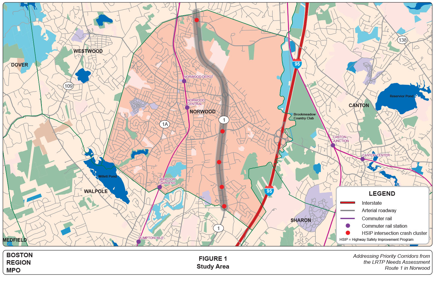
The arterial segment of Route 1 in Norwood received the highest score. Staff also evaluated walking and biking accommodations and safety improvement needs for the segment with the highest score by applying the MPO’s Pedestrian Report Card Assessment and Bicycle Level-of-Service Metric (Bicycle Report Card).5 Based on the assessments, accommodations for people who walk or bicycle on Route 1 in Norwood were rated poor. The location highly qualifies for study based on accommodation for people who walk or bicycle, or safety and operation improvement requirements. Appendix A (attached) contains detailed results of the assessments for Route 1 in Norwood. Based on this evaluation, staff recommends studying the segment on Route 1 in Norwood. Figure 1, located at the end of the memorandum, shows the study area with five HSIP intersection crash clusters.
The arterial segment on Route 1 in Norwood received a total score of 16, based on the selection criteria. Route 1 runs north and south through Norwood, and it serves residential, commercial, industrial, educational, and recreational areas. Within the selected corridor, there are several transportation equity zones that exceed the threshold of the MPO, including minority, limited English proficiency, and carless households.
Being a principal arterial, Route 1 carries local and commuter traffic to and from Boston and connects major east-west roads—Everett Street, Neponset Street, Dean Street, Summer Street, Morse Street, and Union Street. Staff’s evaluation indicates that there are safety and mobility problems in the segment. Five locations along the segment contain HSIP-eligible crash clusters, one of which is in the top 200 of intersection crash clusters in Massachusetts. Also, accommodation for people who bicycle is poor and better bicycle connections are needed in the corridor. Accommodations for people who walk need improvement as there are gaps in the sidewalk network.
MassDOT Highway District 5 has been fielding inquiries about improving the safety of people walking and biking along the corridor. MAPC has been working with the Neponset Valley Transportation Management Association and communities along the Route 1 corridor from Dedham to Foxborough on addressing job and transit access. They are recommending various transit pilot projects, but the long-term recommendation is to make the Route 1 corridor more friendly for people walking, biking, and taking the bus. Appendix B (attached) includes various letters of support for studying Route 1. MassDOT District 5, MAPC, and The Town of Norwood also support studying Route 1 in Norwood to identify solutions to these problems.
For the study, MPO staff would focus on segments of the corridor that would benefit the most, especially regarding safety and for people walking or biking. Staff would also work with stakeholders directly to identify problems and develop solutions. This recommendation meets the selection criteria and supports the transportation improvement policies of the MPO’s LRTP.
MPO staff will present the recommended study location to the MPO board. MPO staff will meet with officials from Norwood, MAPC, MassDOT, and other stakeholders to discuss the study specifics, conduct field visits, collect data, identify needs, and develop solutions.
Table 1
Arterial Segments Considered for Study: Priority Corridors for Long-Range Transportation Plan Needs Assessment Study
| TABLE 1 Arterial Segments Considered for Study: Priority Corridors for Long-Range Transportation Plan Needs Assessment Study |
|||||||||||||||||||||||||
| Arterial Segment | Community | MAPC Subregion | MassDOT District | Jurisdiction | National Highway System | Number of Top-200 High-Crash Locations 2015–17 | Number of HSIP-Eligible Crash Clusters 2015–17** | Crowded or Late Bus | In or Near Transportation Equity Priority Area | Study, Project, or TIP Project | Safety Conditions*** | Congested Conditions*** | Multimodal Significance*** | Regional Significance*** | Regional Equity*** | Implementation Potential*** | Score | Priority Rating | Source of Reference [Hide] | Summary of Comments | |||||
| Route 1 | Norwood | TRIC | 5 | MassDOT | Yes | 1 | 5 | N/A | Yes | MassDOT's I-95 South Corridor Study provided a comprehensive evaluation of the I-95 and Route 1 corridors south of Route 128 that included a recommended plan of short-term and long-term improvements; June 2010. MassDOT Project #609371, Median jersey barrier and fencing upgrade; completed in 2020. MassDOT Project #608052, Route 1 at Morse Street; in design stage. MassDOT Project #608599, Stormwater improvements along Route 1 and I-95; programmed in FFY 2022. MassDOT Project #605857, Route 1 at University Avenue and Everett Street; programmed FFY 2025. MassDOT Project #606545, Median jersey barrier and fencing upgrade; completed in 2012. |
3 | 2 | 3 | 4 | 1 | 3 | 16 | High | FFY 2015 MassDOT D5 comments | MPO staff recommends studying Route 1 in Norwood to address safety, congestion, and multimodal transportation. This four-mile arterial segment serves mixed land uses and has pressing need for safe accommodations for people walking and biking. There are gaps in the sidewalk network and sections of the existing sidewalks are in poor conditions. The existing 6- to 10-foot shoulders need improvements to provide a safe environment for people biking. In addition, safety and operations are concerns, as five locations along the segment contain HSIP-eligible crash clusters, one of which is in the top 200 of intersection crash clusters in Massachusetts. Finally, MAPC has been working with the Neponset Valley Transportation Management Association and communities along the Route 1 corridor from Dedham to Foxborough on addressing job/transit access. They are recommending various transit pilot projects but their long-term recommendation is to make the Route 1 corridor more transit, pedestrian, and bicycle friendly. | |||||
| Route 37 | Braintree | SSC | 6 | MassDOT | Yes | 1 | 2 | Yes | Yes | MassDOT Project #608651, Adaptive traffic signal control on Route 37 (Granite Street). Installation of adaptive traffic control signal equipment, vehicle detection, communication equipment, and managing software at seven traffic signals on Route 37; in construction. MassDOT Project #607684, Bridge replacement, B-21-017, Washington Street (Route 37) over MBTA/CSX railroad; preliminary design. |
3 | 2 | 2 | 4 | 2 | 2 | 15 | High | The arterial segment has a 5- to 6-foot shoulder on either side of the roadway for most of the corridor. There are sidewalks on either side of the roadway throughout the corridor. However, the corridor needs upgrades of its infrastructure for safe accommodations of people walking, biking, or taking transit. MassDOT recently completed installing adaptive traffic control signal equipment, vehicle detection, communication equipment, and managing software at seven traffic signals on Route 37. | ||||||
| Route 3A | Burlington | NSPC | 4 | MassDOT | Yes | 0 | 1 | Yes | Yes | MassDOT Project #608068, Installation of an adaptive traffic control signal system on Cambridge Street, Middlessex Turnpike, and Burlington Mall Road. The project includes the installation of compatible traffic signal control equipment, video detection, communication devices and software to integrate 11 MassDOT and 16 town-owned traffic signal locations into one adaptive signal system; in construction. | 3 | 1 | 3 | 4 | 2 | 1 | 14 | High | On this segment, there are no accommodations for bicycles, gaps in the sidewalk network, and travel lanes that are very wide (drivers form two lanes in each direction). Land use is mixed along the corridor. There are three MBTA bus routes operating in the corridor. Pedestrian and bicycle crashes have occurred in the corridor. The installation of an adaptive traffic control signal system is underway on Cambridge Street, Middlessex Turnpike, and Burlington Mall Road to integrate 11 MassDOT and 16 town-owned traffic signal locations into one adaptive signal system. | ||||||
| Route 9 | Framingham and Natick | MWRC | 3 | MassDOT | Yes | 2 | 6 | No data | Yes | MassDOT Project #609402, Framingham-Natick resurfacing and related work on Route 9; programmed FFY 2025; construction slated to begin summer 2026. MassDOT Project #607732, Framingham-Natick Cochituate Rail Trail. The project involves construction of 2.4 miles of rail trail and includes a grade separated crossing at Routes 9 and 30; in construction. MassDOT Project #608006, Framingham Pedestrian Hybrid Beacon Installation at Route 9 and Maynard Road and the Framingham Fire Station; in design. MassDOT Project #608281, Installation of adaptive traffic control signal equipment, vehicle detection, and communication equipment at five traffic signals in Framingham and Natick on Route 9; in construction. MassDOT Project #608836, Drainage improvements on Route 9 at Route 126 interchange and salt shed relocation (Phase 1); advertised for bids as of June 2021. |
3 | 2 | 3 | 4 | 1 | 1 | 14 | High | MassDOT District 3 comments, FFY 2015 | The FFY 2021 Priority Corridors for LRTP Needs Assessment Study and several MassDOT projects in the corridor will address issues. | |||||
| Route 16 | Medford | ICC | 4 | MassDOT | Yes | 1 | 2 | Yes | Yes | MassDOT Project #604660, Everett-Medford-Bridge Replacements, Revere Beach Parkway (Route 16), E-12-004=M-12-018 over the Malden River (Woods Memorial Bridge) and M-12-017 over MBTA and Rivers Edge Drive; under construction. MassDOT Project #605531, Structure maintenance, E-12-004=M-12-018, Revere Beach Parkway (Route 16) over the Malden River (Woods Memorial Draw Bridge); in construction. |
3 | 2 | 3 | 4 | 0 | 2 | 14 | High | FFY 2015 MassDOT D4 comments | In FFY 2019, MPO staff studied Route 16 in Chelsea and Everett and suggested improvements to address safety, congestion, multimodal transportation, and pedestrian and bicycle accommodations. The section of Route 16 in Medford has five HSIP intersection clusters, including two pedestrian clusters. The roadway experiences congestion and high truck volumes. It also carries vehicular, pedestrian, and bicycle traffic to Wellington Station. Studying this segment in Medford will provide MassDOT with improvement concepts to comprehensively address safety, capacity management and mobility, and accommodations for people walking or biking in the corridor. | |||||
| Route 18 | Weymouth | SSC | 6 | MassDOT | Yes | 3 | 8 | Yes | Yes | MassDOT Project #601630, Reconstruction and widening on Route 18 (Main Street) from Highland Place to Route 139 (4.0 miles) includes replacing W-32-013, Route 18 over the Old Colony Railroad (MBTA); in construction. | 4 | 2 | 2 | 4 | 2 | 0 | 14 | High | MassDOT District 6 comments, FFY 2015 | This arterial segment was not selected because a MassDOT project, currently in construction, would address problems in the entire segment. | |||||
| Route 2A/3 | Arlington | ICC | 4 | Arlington | Yes | 0 | 1 | Yes | Yes | None | 3 | 2 | 3 | 4 | 0 | 1 | 13 | Medium | None | ||||||
| Route 203 | Boston | ICC | 6 | MassDOT | Yes | 5 | 12 | Yes | Yes | MassDOT Project #606318, Intersection improvements at Gallivan Boulevard (Route 203) and Morton Street; in construction. MassDOT Project #608755, Intersection improvements Morton Street (Route 203) at Blue Hill Ave, at Courtland Road/Havelock Street, and at Havard Street; programmed in the FFY 2019 TIP; in design. MassDOT Project #606896, Reconstruction on (Route 203) Gallivan Boulevard, from Neponset Circle to east of Morton Street intersection; in preliminary design. MassDOT Project #606897, Improvements on (Route 203) Morton Street, from west of Gallivan Boulevard to Shea Circle; in preliminary design. |
4 | 2 | 2 | 4 | 0 | 1 | 13 | Medium | The FFY 2012 Priority Corridors for LRTP Needs Assessment Study and several MassDOT projects in the corridor will address issues. | ||||||
| Route 2A | Cambridge | ICC | 6 | Cambridge and DCR | Yes | 1 | 5 | Yes | Yes | The City has been transforming the Route 2A corridor to improve safety for people walking, biking, or riding transit and improve travel times and reliability of bus transit service. The City has implemented separated bike lanes, bus lanes, and parking/loading changes throughout the corridor. | 4 | 2 | 2 | 4 | 0 | 1 | 13 | Medium | The City has implemented several projects to transform Route 2A corridor into a route for everyone and improve safety for people walking, biking, or riding transit. The improvements include separated bike lanes, bus lane, parking/loading times, and traffic signal phase intervals to accomodate people biking. | ||||||
| Route 16 | Chelsea and Everett | ICC | 4 | MassDOT | Yes | 7 | 8 | Yes | Yes | FFY 2019 Priority Corridor for LRTP Needs Assessment Study (Chelsea and Everett) | 4 | 1 | 3 | 4 | 0 | 1 | 13 | Medium | ICC, UPWP Fall 2012, FFY 2015 MassDOT D4 comments | The FFY 2019 Priority Corridors for LRTP Needs Assessment Study and several MassDOT projects will address issues. | |||||
| Route 135 | Framingham | MWRC | 3 | Framingham | Yes | 1 | 2 | No data | Yes | MassDOT Project #606109, Intersection improvements at Route 126/135/MBTA and CSX railroad; in preliminary design. | 4 | 1 | 2 | 4 | 1 | 1 | 13 | Medium | MassDOT Project #606109, Intersection improvements at Route 126/135/MBTA and CSX railroad. Roadway has received improvements to address congestion and make it multimodal (accommodation for people walking or biking). | ||||||
| Route 107 | Lynn | ICC | 4 | MassDOT and Lynn | Yes | 4 | 10 | Yes | Yes | MassDOT Project #808817, Resurfacing of Route 107 and related improvements; programmed FFY 2021. MassDOT Project #608927, Reconstruction of Route 107 in Lynn and Salem; in preliminary design. MassDOT project #609246, Rehabilitation of Western Avenue (Route 107); in preliminary design. MassDOT Project #604952, Bridge Replacement, Route 107 over the Saugus River; programmed 2019. MassDOT Project #26710, Bridge Replacement, Route 107 over the Saugus River (Fox Hill Bridge); completed spring 2013. |
4 | 1 | 3 | 4 | 0 | 1 | 13 | Medium | This arterial segment was the subject of a Route 107 Corridor Study in Lynn and Salem, which was completed by MassDOT in 2016. The proposed improvements would be addressed under Project #608927; currently in design. | ||||||
| Route 16 | Milford | SWAP | 3 | MassDOT and Milford | Yes | 0 | 3 | No data | Yes | MassDOT Project #607428, Resurfacing and intersection improvements on Route 16 (Main Street), from Water Street west to approximately 120 feet west of the Milford/Hopedale town line and the intersection of Route 140; programmed FFY 2019. MassDOT Project #606142, Signal and intersection improvements on Route 16 (Main Street and East Main Street) at six locations; completed in 2013. |
3 | 2 | 2 | 4 | 1 | 1 | 13 | Medium | This corridor received improvements in 2013 based on a CTPS study, and a MassDOT resurfacing and intersection improvement project was programmed for FFY 2019. | ||||||
| Route 3A | Quincy | ICC | 6 | MassDOT, DCR, and Quincy | Yes | 1 | 10 | Yes | Yes | MassDOT Project #608569, Intersection improvements at Route 3A (Southern Artery) and Broad Street; programmed FFY 2022 TIP. MassDOT Project #605729, Intersection and signal improvements at Hancock Street and East/West Squantum streets; completed in 2015. An FFY 2012 CTPS safety and operations study addressed problems at the Route 3A and Coddington Street intersection. |
4 | 2 | 2 | 4 | 0 | 1 | 13 | Medium | Route 3A (Hancock Street and Southern Artery) has received several improvement projects and was the focus of a CTPS study. The location was suggested in the 2017 MPO Outreach Program. |
||||||
| Route 28 | Randolph | TRIC | 6 | MassDOT and Randolph | Yes | 3 | 9 | Yes | Yes | MassDOT Project #609399, Resurfacing and related work on Route 28; in preliminary design. Arterial Coordination Study, CTPS study (2010). |
4 | 2 | 2 | 4 | 0 | 1 | 13 | Medium | MassDOT District 6 comments, FFY 2015 | The location has a potential MassDOT resurfacing project and could benefit from some upgrades for safe accommodations for people walking, biking, or riding bus transit. | |||||
| Route 114 | Salem | NSTF | 4 | MassDOT and Salem | Yes | 0 | 1 | Yes | Yes | MassDOT Project #608521, Bridge Maintenance, North Street (Route 114) over Bridge Street (Route 107) and MBTA; in construction. MassDOT Project #605332, Bridge Replacement (Route 114) North Street over North River; in design stage. |
3 | 2 | 2 | 4 | 1 | 1 | 13 | Medium | This roadway has had Complete Streets improvements, including sidewalks and bicycle lanes on either side of the roadway. The section that requires improvements to address safety, capacity management and mobility, and accommodate bicycles is between Bridge Street (Route 107) and Route 128. | ||||||
| Route 16 | Wellesley | MWRC | 6 | MassDOT and Wellesley | Yes | 0 | 0 | N/A | Yes | MassDOT Project #94762, Bridge Rehabilitation, Br# W-13-014 Route 16 (Washington Street) over Route 9 including relocation of retaining wall; completed. | 3 | 2 | 2 | 4 | 1 | 1 | 13 | Medium | FFY 2015 LRTP Outreach | The location was suggested in 2014 LRTP outreach through verbal comments at a 495/MetroWest Partnership meeting. | |||||
| Route 3A | Weymouth | SSC | 6 | MassDOT | Yes | 0 | 1 | Yes | Yes | MassDOT Project #608231, Reconstruction of Route 3A including pedestrian and traffic signal improvements; in design. MassDOT Project #604382, Route 3A (Washington Street) Bridge; in construction. MassDOT Project #608483, Work consists of resurfacing on Route 3A; in preliminary design. |
2 | 2 | 2 | 4 | 2 | 1 | 13 | Medium | A road safety audit was completed for Route 3A in Weymouth in September 2016. The audit identified the problems and needs on the roadway, and suggested short-, medium-, and long-term improvements. MassDOT Project #608321, in design, will address problems and needs identified in the corridor. | ||||||
| Routes 38/129 | Wilmington | NSPC | 4 | MassDOT and Wilmington | Yes | 0 | 3 | N/A | Yes | MassDOT Project #608051, Reconstruction of Route 38 from Route 62 to the Woburn city line, add bike lanes, sidewalks, and turn lanes, and upgrade signals; programmed FFY 2024. MassDOT Project #609253, Intersection improvements at Lowell Street (Route 129) and Woburn Street; programmed FFY 2024. MassDOT Project #601732, Rehabilitation, Route 129 (Lowell Street) from Route 38 (Main Street) to Woburn Street; completed in 2009. |
2 | 2 | 2 | 4 | 2 | 1 | 13 | Medium | Several sections of the arterial have projects that are currently in design. These MassDOT projects would address problems in the corridor. | ||||||
| Route 2/3/3A/16 | Cambridge | ICC | 6 | DCR | Yes | 3 | 4 | Yes | Yes | DCR conducted a traffic study of several intersections along Mount Auburn Street and Fresh Pond Parkway, in partnership with the City of Cambridge, MassDOT, and the MBTA. MassDOT Project #608806, Multiuse Path Contruction (Phase II), Create a multiuse greenway on the former B&M railroad right-of-way extending from Concord Avenue in Cambridge through the Fresh Pond Reservation, under Huron Avenue and Mount Auburn Street and into Watertown; this project is in construction. MassDOT Project #609290, Intersection improvements at Fresh Pond Parkway/Gerrys Landing Road, from Brattle Road to Memorial Drive. |
3 | 2 | 2 | 4 | 0 | 1 | 12 | Medium | LRTP FFY 2015 Outreach | DCR and the City of Cambridge studied the portion of the corridor at and south of Mount Auburn Street . The study focused on safety measures, bus prioritization, and accessibility. | |||||
| Route 2 | Concord | MAGIC | 4 | MassDOT | Yes | 0 | 3 | N/A | Yes | MassDOT Project #602984, Crosby's Corner (Route 2 at Route 2A) improvements; completed. MassDOT Project #608015, Reconstruction and widening on Route 2, from Sandy Pond Road to Bridge over MBTA/B&M railroad; in preliminary design MassDOT Project #602091, Concord Rotary; in preliminary design. MassDOT Project #604069, Bridge Replacement over Sudbury River; in preliminary design. MassDOT Project #606223: Bruce Freeman Rail Trail Construction (Phase II-B) in Acton and Concord; in construction. |
2 | 2 | 2 | 4 | 1 | 1 | 12 | Medium | FFY 2013 Priority Corridors for LRTP Needs Assessment Study (Concord and Lincoln) Route 2 was suggested during MPO outreach as a route experiencing congestion that affects MAGIC communities and Cambridge. There are many projects and studies conducted for this corridor, including the Route 2 (Crosby's Corner) improvements and Concord Rotary upgrade and improvements. |
||||||
| Route 99 | Everett | ICC | 4 | Everett | Yes | 0 | 1 | Yes | Yes | MassDOT Project #602383, Reconstructed Route 99 with a traffic signal upgrade, from Second Street to the Malden city line; completed in 2008. MassDOT Project #602382, Reconstructed Route 99 from Sweetser Circle to the Alford Street Bridge in 2013; completed spring 2013. |
2 | 2 | 3 | 4 | 0 | 1 | 12 | Medium | This roadway is not recommended for study because MassDOT completely reconstructed Route 99 with signal improvements from the Alford Street Bridge to the Malden city line. Route 99 (Lower Broadway) has also received improvements, including pedestrian and bicycle accommodation, as a result of the Encore Boston Harbor mitigation improvements. | ||||||
| Route 3A | Hingham | SSC | 5 | MassDOT | Yes | 0 | 1 | Yes | Yes | MassDOT Project #605168, Improvements on Route 3A from Otis Street/Cole Road including Summer Street and rotary and Rockland Street to George Washington Boulevard; in design. | 2 | 1 | 2 | 4 | 2 | 1 | 12 | Medium | UPWP and LRTP outreach in 2012, 2013, and 2014, FFY 2015 MassDOT D5 comments, FFY 2015 Representative Bradley letter | In FFY 2015, a subregional priority roadway study was conducted for Route 3A in Hingham and Hull. The location received strong support from the Towns of Hingham and Hull, as well as the South Shore Coalition and the MassDOT Highway Division District 5 Office. |
|||||
| Route 28 | Milton | ICC and TRIC | 6 | MassDOT and Milton | Yes | 1 | 3 | Yes | Yes | MassDOT Project #607342, Intersection and Signal Improvements at Route 28 (Randolph Avenue) and Chickatawbut Road; programmed FFY 2022. MassDOT Project #609396, Resurfacing and related work on Route 28; programmed FFY 2024. MassDOT Project # 106901, Reconstruction on Route 28 (Randolph Avenue) from Reedsdale Road to Quincy town line; completed in 2008. |
4 | 2 | 3 | 3 | 0 | 0 | 12 | Medium | MassDOT District 6 comments, FFY 2015 | This arterial segment was studied in FFY 2020. There are four HSIP intersection clusters in the segment. There is no accommodation for bicycles in the segment, which presents a significant connectivity problem because several of the side streets have bicycle lanes. There are peak period traffic congestion problems that create safety, operations, and mobility issues for the residents. In addition, recommendations from the study could be incorporated into MassDOT Project #609396 or a new project. | |||||
| Route 114 | Peabody | NSTF | 4 | MassDOT and Peabody | Yes | 0 | 2 | Yes | Yes | MassDOT Project # 608567, Improvements at Route 114 at Sylvan Street, Cross Street, Northshore Mall, Loris Road, Route 128 Interchange, and Esquire Drive; in design. | 3 | 2 | 2 | 3 | 1 | 1 | 12 | Medium | Route 114 in Peabody was listed as a potential corridor in need of signal progression and improvements to accommodate people who walk and bike. However, the arterial segment was not selected because, according to MassDOT Highway District 4, a road safety audit was completed for the segment in August 2016 and a consultant has started design work as part of Project #608567; in design. | ||||||
| Route 16 (Revere Beach Parkway) | Revere | ICC | 4 | MassDOT | Yes | 0 | 1 | Yes | Yes | None | 2 | 2 | 3 | 4 | 0 | 1 | 12 | Medium | FFY 2015 MassDOT D4 comments | This location is not recommended for study because the Suffolk Downs Redevelopment project is evaluating several scenarios that would affect traffic on Route 16 and Route 1A. | |||||
| Route 107 | Salem | NSTF | 4 | MassDOT and Salem | Yes | 0 | 1 | Yes | Yes | Route 107 Corridor Study in Salem and Lynn; completed in 2016. MassDOT Project #608059, Stormwater improvements along Route 107 (Salem Bypass Road); in construction. MassDOT Project #608650, Adaptive Signal Controls on Route 107 (Highland Avenue); in construction. MassDOT Project #608817, Resurfacing and related work on Route 107; in construction. MassDOT Project #608927, Reconstruction of Route 107; in preliminary design. |
3 | 2 | 2 | 4 | 1 | 0 | 12 | Medium | The Route 107 corridor in Lynn and Salem was studied in 2016 and many of the recommendations have advanced into MassDOT projects. The proposed improvements would be addressed under Project #608927; currently in design. | ||||||
| Route 1A | Salem | NSTF | 4 | MassDOT and Salem | Yes | 0 | 0 | Yes | Yes | MassDOT Project #605146, Reconstruction of Canal Street from Washington Street and Mill Street to Loring Avenue (Route 1A) and Jefferson Street; completed in 2018. MassDOT Project #601017, Reconstruction of Route 1A (Bridge Street) from the Beverly/Salem Bridge to Washington Street (6,000 feet); completed in 2013. |
3 | 1 | 2 | 4 | 1 | 1 | 12 | Medium | The southern end of this arterial segment was included in the study of Route 1A at Vinnin Square in Marblehead and in Swampscott; this location was selected as the subject of the FFY 2016 Priority Corridors Study. The intersection of Route 1A and Jefferson Street and Canal Street was reconstructed in 2018. | ||||||
| Route 16 | Sherborn | SWAP | 3 | Sherborn | Yes | 0 | 2 | N/A | Yes | None | 2 | 2 | 1 | 4 | 1 | 2 | 12 | Medium | FFY 2015 LRTP Outreach, MassDOT District 3 comments, FFY 2015 | This location was suggested during 2014 LRTP outreach at a 495/MetroWest Partnership meeting. The section that experiences the most crashes and congestion is in the town center, where Route 16 and Route 27 combine and split. |
|||||
| Route 20 | Waltham | ICC | 6 | MassDOT and Waltham | Yes | 0 | 3 | Yes | Yes | City of Waltham Transportation Master Plan, January 2017. | 3 | 2 | 2 | 4 | 0 | 1 | 12 | Medium | This location had been studied and improvements proposed in the Waltham Transportation Master Plan. | ||||||
| Route 20 | Weston | MWRC | 6 | MassDOT | Yes | 0 | 3 | Yes | No | Intersection improvements on Boston Post Road (Route 20) at Wellesley Street; in design stage. | 3 | 2 | 2 | 3 | 1 | 1 | 12 | Medium | UPWP/LRTP outreach in 2012, 2013, and 2014 by MAGIC | A suggestion to study this location was resubmitted in a comment on the Draft FFY 2014 UPWP and during the 2017 MPO Outreach Program. | |||||
| Route 60 | Arlington | ICC | 4 | Arlington | Yes | 0 | 1 | Yes | Yes |
CTPS and MAPC Community Transportation Technical Assistance Program evaluated the high-crash location at the intersection at Massachusetts Avenue in March 2010. MassDOT Project #606885, Reconstructed the intersection of Route 3 and Route 60; completed in 2017. |
2 | 2 | 3 | 3 | 0 | 1 | 11 | Low | None | ||||||
| Route 16 | Holliston | MWRC | 3 | MassDOT and Holliston | Yes | 0 | 2 | No data | No | 2011 CTPS study, Route 126 Corridor: Transportation Improvement Study. 2008 CTPS study, Washington Street (Route 16/126) at Hollis Street. |
2 | 1 | 2 | 3 | 1 | 2 | 11 | Low | FFY 2015 LRTP Outreach, MassDOT District 3 comments, FFY 2015 | This location has MassDOT projects and CTPS studies, which have not been implemented. The 495/MetroWest Partnership expressed interest in a Route 16 study. The section that experiences the most crashes is the town center portion (under Holliston jurisdiction). A road safety audit was performed for the town center portion in December 2012. |
|||||
| Route 60 | Medford | ICC | 4 | Medford | No | 0 | 1 | Yes | Yes | None | 3 | 2 | 3 | 2 | 0 | 1 | 11 | Low | None | ||||||
| Route 138 | Milton | ICC and TRIC | 6 | MassDOT | Yes | 0 | 1 | Yes | Yes | MassDOT Project #608484, Roadway Improvements on Route 138; programmed FFY 2020. FFY 2018 LRTP Priority Corridor Study |
2 | 2 | 2 | 4 | 0 | 1 | 11 | Low | UPWP Outreach in 2013 | FFY 2018 Priority Corridors for LRTP Needs Assessment Study. MassDOT Project #608484, Roadway Improvements on Route 138, will address problems and needs in the corridor. |
|||||
| Route 9 | Newton | ICC | 6 | MassDOT | Yes | 0 | 4 | Yes | Yes | MassDOT Project #608821, Resurfacing and related work on Route 9; in preliminary design. MassDOT Project #604327, Resurfacing and Related Work on Route 9 (Boylston Street) from the Wellesley/Newton city line to Newton/Brookline city line; completed in summer 2012. MassDOT Project #606635, Reconstruction of Highland Avenue, Needham Street, and Charles River Bridge, from Webster Street to Route 9; programmed FFY 2019. |
2 | 2 | 2 | 4 | 0 | 1 | 11 | Low | MassDOT District 6 comments, FFY 2015 | According to MassDOT District 6, improvements were recently made to accommodate new developments. An analysis of the new existing conditions would be helpful to compare with the future projected conditions. | |||||
| Route 129 | Reading | NSPC | 4 | MassDOT and Reading | Yes | 0 | 0 | Yes | Yes | No projects | 3 | 1 | 2 | 2 | 2 | 1 | 11 | Low | None | ||||||
| Route 9 | Wellesley | MWRC | 6 | MassDOT | Yes | 0 | 3 | No data | Yes | MassDOT Project #608180, Resurfacing on Route 9, from limit of add-a-lane to east of Overbrook intersection; in construction. MassDOT Project #606530, Drainage improvements along Route 9 Boulder Brook Culvert (design only); in design. MassDOT Project #607340, Resurfacing and related work on Route 9 from Dearborn Street to Natick town line; in preliminary design. MassDOT Project #609402, Resurfacing and related work on Route 9; in preliminary design. MassDOT Project #94762, Bridge Rehabilitation, Route 16 (Washington Street) over Route 9, including relocation of retaining wall; completed summer 2010. MAPC Land Use/Corridor Study (fall 2013). |
2 | 1 | 2 | 4 | 1 | 1 | 11 | Low | MassDOT District 6 comments, FFY 2015 | MassDOT Project #609402 has completed a preliminary assessment of this corridor that will develop into 25 percent design plans for roadway improvements. This project is planned to be funded through the 2026 TIP. | |||||
| Route 1 | Westwood | TRIC | 6 | MassDOT | Yes | 0 | 0 | N/A | Yes | MassDOT's I-95 South Corridor Study provided a comprehensive evaluation of the I-95 and Route 1 corridors south of Route 128 and included a recommended plan of short-term and long-term improvements; June 2010. MassDOT Project #603162, Route 128 Add-a-Lane Bridges (Bridge III), Route 1 and 1A over I-95/128; completed in 2012. |
2 | 2 | 2 | 4 | 0 | 1 | 11 | Low | MassDOT District 6 comments FFY 2015 | This arterial segment serves mixed land uses but there are no safe accommodations for people walking or biking as there are no sidewalks in the segment and the existing 6- to 10-foot shoulders need improvements to provide safe environment for people biking. MAPC has been working with the Neponset Valley Transportation Management Association and communities along the Route 1 corridor from Dedham to Foxborough on addressing job/transit access are recommending long-term term improvements to make Route 1 corridor more transit, pedestrian, and bicycle friendly. | |||||
| Route 62 | Concord | MAGIC | 4 | Concord | Yes | 0 | 2 | N/A | Yes | MassDOT Project #604646, Reconstruction of Main Street (Route 62) from Water Street to the Acton town line; completed 2010. | 2 | 2 | 2 | 2 | 1 | 1 | 10 | Low | None | ||||||
| Route 135 | Natick | MWRC | 3 | MassDOT and Natick | Yes | 0 | 1 | No data | Yes | MassDOT Project #600573, Reconstructed Route 135 in Natick in 2008. More extensive improvements were proposed in the downtown area, on East Central Street between North Main Street and Union Street, including signal upgrades, new sidewalks, pavement rehabilitation, and shoulders; all construction operations were suspended (as of June 30, 2007). 2010 CTPS study, West Central Street (Route 135) at Speen Street. |
3 | 1 | 2 | 2 | 1 | 1 | 10 | Low | MassDOT District 3 comments, FFY 2015 | There is congestion in the downtown area and the likely focus area would be on the intersection of Route 135 at Route 27 and the intersection of Route 135 at Speen Street due to the crash history of those locations. | |||||
| Route 1 | Walpole | TRIC | 5 | MassDOT | Yes | 0 | 3 | N/A | No | MassDOT's I-95 South Corridor Study presented a comprehensive evaluation of the I-95 and Route 1 corridors south of Route 128 and included a recommended plan of short-term and long-term improvements; June 2010. MassDOT Project #608480, Resurfacing and related work on Route 1; programmed FFY 2020. |
2 | 1 | 3 | 3 | 0 | 1 | 10 | Low | FFY 2015 MassDOT D5 comments | This arterial segment serves mixed land uses but there are no safe accommodations for people walking or biking as there are no sidewalks in the segment and the existing 6- to 10-foot shoulders need improvements to provide safe environment for people biking. MAPC has been working with the Neponset Valley Transportation Management Association and communities along the Route 1 corridor from Dedham to Foxborough on addressing job/transit access. They are recommending long-term term improvements to make Route 1 corridor more transit, pedestrian, and bicycle friendly. | |||||
| Route 117 | Bolton | MAGIC | 3 | Bolton | 0 | 0 | N/A | Yes | None | 1 | 1 | 2 | 3 | 1 | 1 | 9 | Low | None | |||||||
| Route 38 | Wilmington | NSPC | 4 | MassDOT and Wilmington | Yes | 0 | 2 | Yes | 2 | 2 | 3 | 7 | Low | ||||||||||||
| Notes: | |||||||||||||||||||||||||
| **Number of HSIP-eligible crash clusters EPDO is a method of combining the number of crashes with the severity of crashes based on a weighted scale. Since 2018, MassDOT applied a new EPDO method (where actual crash costs are factored in) to rank high-crash locations in the state. All of the fatal and injury crashes were weighted together (about 30 percent of all crashes in Massachusetts), which resulted in any crash resulting in an injury (including fatal, incapacitating, non-incapacitating, and possible injuries) having a weighting factor of 21 compared to a crash that resulted in property damage only, which would have a weighting factor of one. |
|||||||||||||||||||||||||
| ***Selection Criteria Safety Conditions: Segment has a high crash rate for its functional class, contains an HSIP-eligible crash location, a top-200 high-crash location, and/or a significant number or HSIP-eligible clusters of pedestrian or bicycle crashes. Congested Conditions: Segment has a Travel Time Index of at least 1.3 and/or of at least 2.0, that is, which signify that it experiences delays during peak periods. Multimodal Significance: Segment supports transit or bicycle or pedestrian activities, has a need to improve these activities, and/or has a high volume of truck traffic serving regional commerce. Regional Significance: Segment is in the National Highway System, carries a significant proportion of regional traffic, lies within 0.5 miles of environmental justice transportation analysis zones, and/or is essential for regional economic, cultural, or recreational development in the area. Regional Equity: Location is in a subregion that has not had a priority corridor study before, or location is in a subregion that has not had a priority corridor study in the last three years. Implementation Potential: Improvements to the segment are proposed or endorsed by the roadway administrative agency (agencies), proposed or endorsed by the subregion and are a priority for the subregion, and/or have strong support from other stakeholders. |
|||||||||||||||||||||||||
| ADA = Americans with Disabilities Act. BAT = Brockton Area Transit Authority. CTPS = Central Transportation Planning Staff. DCR = Department of Conservation and Recreation. EPDO = Equivalent Property Damage Only. FFY = federal fiscal year. HSIP = Highway Safety Improvement Program. I-95 = Interstate 95. ICC = Inner Core Committee. LRTP = Long-Range Transportation Plan. MAGIC = Minuteman Advisory Group on Interlocal Coordination. MAPC = Metropolitan Area Planning Council. MassDOT = Massachusetts Department of Transportation. MBTA = Massachusetts Bay Transportation Authority. MPO = Metropolitan Planning Organization. MWRC = MetroWest Regional Collaborative. MWRTA = MetroWest Regional Transit Authority. NSPC = North Suburban Planning Council. NSTF = North Shore Task Force. PRC = Project Review Committee. SSC = South Shore Coalition. SWAP = South West Advisory Planning Committee. TIP = Transportation Improvement Program. TRIC = Three Rivers Interlocal Council. UPWP = Unified Planning Work Program. | |||||||||||||||||||||||||
| Source: Central Transportation Planning Staff. | |||||||||||||||||||||||||
Figure 1
Study Area
The Boston Region Metropolitan Planning Organization (MPO) operates its programs, services, and activities in compliance with federal nondiscrimination laws including Title VI of the Civil Rights Act of 1964 (Title VI), the Civil Rights Restoration Act of 1987, and related statutes and regulations. Title VI prohibits discrimination in federally assisted programs and requires that no person in the United States of America shall, on the grounds of race, color, or national origin (including limited English proficiency), be excluded from participation in, denied the benefits of, or be otherwise subjected to discrimination under any program or activity that receives federal assistance. Related federal nondiscrimination laws administered by the Federal Highway Administration, Federal Transit Administration, or both, prohibit discrimination on the basis of age, sex, and disability. The Boston Region MPO considers these protected populations in its Title VI Programs, consistent with federal interpretation and administration. In addition, the Boston Region MPO provides meaningful access to its programs, services, and activities to individuals with limited English proficiency, in compliance with U.S. Department of Transportation policy and guidance on federal Executive Order 13166. The Boston Region MPO also complies with the Massachusetts Public Accommodation Law, M.G.L. c 272 sections 92a, 98, 98a, which prohibits making any distinction, discrimination, or restriction in admission to, or treatment in a place of public accommodation based on race, color, religious creed, national origin, sex, sexual orientation, disability, or ancestry. Likewise, the Boston Region MPO complies with the Governor's Executive Order 526, section 4, which requires that all programs, activities, and services provided, performed, licensed, chartered, funded, regulated, or contracted for by the state shall be conducted without unlawful discrimination based on race, color, age, gender, ethnicity, sexual orientation, gender identity or expression, religion, creed, ancestry, national origin, disability, veteran's status (including Vietnam-era veterans), or background. A complaint form and additional information can be obtained by contacting the MPO or at http://www.bostonmpo.org/mpo_non_discrimination. To request this information in a different language or in an accessible format, please contact Title VI Specialist By Telephone: For people with hearing or speaking difficulties, connect through the state MassRelay service:
For more information, including numbers for Spanish speakers, visit https://www.mass.gov/massrelay
|
Appendix A: Pedestrian and Bicycle Report Cards
Appendix B: Letters of Support
1 Destination 2040: The New Long-Range Transportation Plan of the Boston Region Metropolitan Planning Organization was adopted by the Boston Region MPO in August 2019.
2 The FFY 2022 UPWP was endorsed by the Boston Region MPO on August 19, 2021. The FFY 2022 UPWP was reviewed by the MPO’s federal partners and went into effect on October 1, 2021.
3 A Complete Street is one that provides safe and accessible options for all travel modes, such as walking, biking, transit, and vehicles, for people of all ages and abilities.
4 Beth Isler, Bicycle Network Evaluation (Boston Region Metropolitan Planning Organization, May 2014), https://www.ctps.org/data/pdf/programs/livability/MPO_0515_Bicycle_Network.pdf.
5 Ryan Hicks and Casey-Marie Claude, Boston Region Metropolitan Planning Organization, Pedestrian Level-of-Service Memorandum, January 19, 2017; Casey-Marie Claude, Boston Region Metropolitan Planning Organization, Development of a Scoring System for Bicycle Travel in the Boston Region, November 8, 2018.