Technical Memorandum
DATE: May 6, 2021
TO: Chris Cassani, Director of Traffic, Parking, Alarm and Lighting, City of Quincy
FROM: Chen-Yuan Wang and Mark Abbott, Boston Region Metropolitan Planning Organization Staff
RE: Safety and Operations Analyses at Selected Intersections, FFY 2020—Adams Street at Furnace Brook Parkway and Common Street in Quincy
This memorandum summarizes safety and operations analyses for the intersections of Adams Street at Furnace Brook Parkway and at Common Street in Quincy and proposes improvement strategies for this location. The two intersections were selected for this federal fiscal year 2020 study through a comprehensive review of 30 potential locations in the region.1
The memorandum contains the following sections:
In addition, the memorandum includes technical appendices that contain supporting data and methods applied in the study.
The purpose of the “Safety and Operations Analyses at Selected Intersections” study is to examine safety, operations, and mobility issues at major intersections in the Boston Region Metropolitan Planning Organization’s (MPO) planning area, particularly on arterial highways where many crashes occur, congestion during peak traffic periods may be heavy, or improvements for bus, bicycle, and pedestrian travel are needed.
For more than 10 years, the MPO has been conducting these planning studies with municipalities in the region. The communities find the studies beneficial, as they provide an opportunity to begin looking at the needs of problematic locations at the conceptual level before municipalities commit funds for design and engineering. Eventually, if the project qualifies for federal funds, the study’s documentation will also be useful to the Massachusetts Department of Transportation (MassDOT) and its project-development process.
These studies support the MPO’s visions and goals, which include increasing transportation safety, maintaining the transportation system, advancing mobility, and reducing congestion.
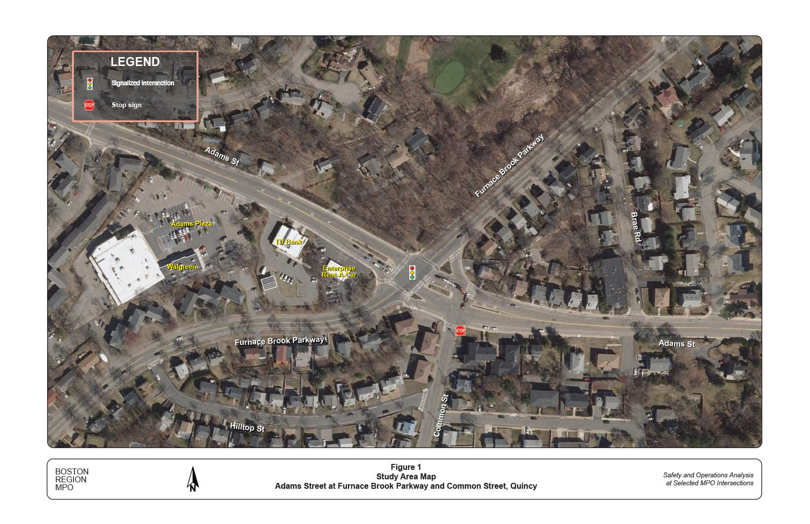
The study location is in West Quincy, about one mile from the city center. The two intersections, Adams Street at Furnace Brook Parkway and at Common Street, are located closely within 150 feet. The intersection of Adams Street and Furnace Brook Parkway was first identified as a high crash location with pedestrian safety concerns. Further review indicates that the intersection of Adams Street and Common Street also has a high crash rate. The safety and operations of the two intersections are highly correlated and must be analyzed together.
The adjacent land uses are primarily residential with commercial developments concentrated on the south side of Adams Street west of Furnace Brook Parkway. The residential developments are mostly single family homes, with a number of multi-family condos and apartments located near the two intersections. The commercial developments include Walgreens, In Sync Center of the Arts, Unchained Pizza, and Dunkin’ Donuts in Adams Plaza, and TD Bank and Enterprise Rent-A-Car on the street front. A primary school, Charles A. Bernazzani Elementary School, is located on Furnace Brook Parkway about 500 feet east of Adams Street. Figure 1 shows the location of the intersection, existing street layouts, and major developments in the study area.
Adams Street is a principal arterial under the city’s jurisdiction. From Quincy Center, it heads northwest through West Quincy, across Interstate 93, through East Milton, and connects Dorchester Avenue in the Dorchester neighborhood of Boston. It is a two-lane roadway (one lane in each direction) that carries local
Figure 1
Study Area Map
Adams Street at Furnace Brook Parkway and Common Street, Quincy
and regional traffic. Traffic is busy during the AM and PM peak periods. The section of Adams Street in the study area has a speed limit of 30 miles per hour (mph) in both directions.
Furnace Brook Parkway is a historical parkway owned and maintained by the Massachusetts Department of Conservation and Recreation (DCR). The parkway was built to connect Blue Hill Reservation and Quincy Shore Reservation as part of the parks network in the areas surrounding Boston in early 1990s. Following the courses of Furnace Brook and Blacks Creek, it meanders through the city from southwest to northeast. Today it also serves the homes and local businesses in the adjacent areas and is classified as an urban minor arterial.
Similar to Adams Street, the two-lane parkway carries busy local and regional traffic during the AM and PM peak periods. Trucks are prohibited on the parkway. Based on observations, most sections of Furnace Brook Parkway in the vicinity have a 30 mph speed limit, except the section from Brae Road to Bernazani Primary School (20 mph speed limit) and the winding section east of the school (25 mph speed limit).
The intersection of Adams Street at Furnace Brook Parkway is signalized. The signal operates in a simple three-phase mode—one for Adams Street traffic, one for Furnace Brook Parkway traffic, and one exclusively for pedestrian crossings. Both Adams Street approaches widen to accommodate turning movements. The westbound approach expands from a single lane to include an exclusive left-turn lane and two through lanes (one is a short section between the right-turn channel of the approach and the stop line). The eastbound approach expands to two lanes, one for left-turn and through movements and one for through and right-turn movements. On Furnace Brook Parkway, the southbound approach maintains a single lane for all movements, and the northbound approach flares slightly to allow traffic forming two lanes near the stop line, one for left-turn and one for through and right-turn movements.
All the right turns at the intersection are channelized, except the southbound approach. Right turns from Adams Street westbound are under a traffic signal control that is synchronized with the east-west signal phase. Both the right turns from Adams Street are under No Turn on Red (NTOR) regulation during 7:00–8:00 AM, 11:00 AM–12:00 PM, and 2:00–3:00 PM on school days. On Furnace Brook Parkway, right turns are under Yield control for the northbound approach and no separate control for the southbound approach, with right turns on red are allowed.
Crosswalks exist on all approaches of the intersection, next to the stop lines and across the right-turn channels. Pedestrian signals and push buttons are located near the intersection on the three channelized islands and at the northeast street corner. The signals display the conventional walking person (symbolizing walk) and upraised hand (symbolizing stop), with no count-down or accessible (audible) functions. During the primary school opening and closing hours, there is a school crossing guard to actuate pedestrian signals and assist students crossing the intersection.
Common Street is owned by the city and classified as a major connector. The two-lane roadway is about a mile long, running parallel to Furnace Brook Parkway from Central Street (near Interstate 93) northerly to end at Adams Street. People often use it as a short cut to bypass Furnace Brook Parkway, especially during the AM and PM peak periods when the parkway is congested.
The intersection of Adams Street at Common Street is unsignalized, with the Common Street approach under stop control. In addition to right- and left-turns to Adams Street, through movements from Common Street are allowed to cross Adams Street and continue on the parkway northbound via the channelized right-turn lane on Adams Street. At the intersection, Common Street maintains a single lane for all movements. During the peak hours when the Adams Street traffic is busy, there are usually 10 to 20 vehicles queuing on Common Street. In this situation, drivers scramble to find gaps in traffic on Adams Street and tend to drive aggressively.
On Adams Street, the westbound approach widens to include an exclusive left-turn lane and a through and right-turn shared lane. The eastbound approach has two lanes continuing from Furnace Brook Parkway to this intersection. After the intersection, it gradually tapers down to one lane.
There is a crosswalk on Common Street and no crosswalks on Adams Street. Adams Street at this intersection is wide and difficult for pedestrians to cross. In principal, pedestrians are encouraged to use crosswalks at the Furnace Brook Parkway intersection.
The most congested part of this study location is the short section of Adams Street westbound between Common Street and Furnace Brook Parkway. During peak hours, heavy traffic from Adams Street westbound and the northbound through traffic from Common Street frequently jams in this section, which is less than 100 feet long. A “Do Not Block” hatched box pavement marking exists on Adams Street westbound at the Common Street intersection. It appears to have little effect to prevent blockage by drivers who jockey for position to pass the parkway intersection.
On-street parking is allowed on both sides of Adams Street east of Common Street. The section of Adams Street remains relatively wide with a 13-foot travel lane in each direction and ten-foot shoulders on both sides. No specific parking prohibition signs are posted, except the prohibition of parking during snow emergencies (Adams Street is a designated emergency arterial). Field observations indicate that one or two vehicles occasionally park very close to the Common Street intersection, which impedes the intersection operations, especially during the peak hours.
Massachusetts Bay Transportation Authority (MBTA) local bus Route 245 (Quincy Center Station—Mattapan Station) runs along Adams Street and Common Street. It serves the area, with stops at Adams Plaza and adjacent neighborhoods. There are no stops at the two intersections. The nearest bus stop is located on Common Street about 200 feet south of Adams Street at the corner of Hilltop Street.
Sidewalks exist on both sides of all the roadways approaching the two intersections, except a short section of about 200 feet on the west side of Furnace Brook Parkway (from the Enterprise Rent-A-Car driveway to the adjacent apartment). With the dense residential and commercial developments and the nearby primary school, there are intensive pedestrian activities when traffic conditions are busy, especially during the AM and PM peak periods.
No dedicated bicycle accommodations exist on the roadways approaching the intersections. Five-foot or more shoulders exist in limited sections of Adams Street but they are frequently disrupted by on-street parking. Five-foot shoulders exist in some sections of Furnace Brook Parkway. With trucks prohibited, the parkway is popular with commuter and recreational cyclists.
Based on MPO staff’s field observations, discussions with the city officers, and analyses of crash data and existing operations, major issues and concerns at the intersection include the following:
Crash data analysis is essential to identify safety and operational problems at an intersection. Analyzing data on the frequency of crashes, types and patterns of collisions, and the circumstances under which crashes occur, such as the time of day and roadway surface conditions, also helps to develop improvement strategies.
MPO staff used the most recent five-year crash reports (January 2015–November 2019) from the Quincy Police Department for this study. To account for crashes that intersection operations may have contributed to, staff examined the crashes in the section of Adams Street between Adams Plaza and Brae Road. The section covers the two intersections (the study location) and 500 feet beyond in the both directions of Adams Street.
In total, there were 98 crashes in the recent five-year period in the section. They can be classified in three categories:
At the study location, the predominant crash type was the angle collision involving a left-turning vehicle and a through vehicle (known as left-turn crashes). Thirty-eight such crashes (53 percent of the total) occurred at the two intersections. Additionally, 11 crashes (15 percent of the total) were identified as right-angle collisions that involved two vehicles from two different approaches running into each other. In sum, 49 crashes (68 percent of the total 72 crashes) were identified as angle collisions. This result is alarming because angle collisions usually cause more severe personal injuries and property damage than rear-end collisions at an intersection.
Table 1 summarizes the 72 crashes in terms of severity, collision type, pedestrian or bicycle involvement, time of the day, and weather and pavement conditions. Fifteen of the crashes (21 percent) caused personal injuries with no fatalities. The collision types included 49 angle collisions (68 percent), eight rear-end collisions (11 percent), eight same direction sideswipe collisions (11 percent), and three single vehicle crashes.
Noticeably, about 40 percent of the crashes occurred during peak traffic periods (7:00–10:00 AM and 3:30–6:30 PM), which reflects the study location’s recurrent congested conditions during peak AM and PM periods. Meanwhile, nearly 30 percent of the crashes occurred during darkness. The two adjacent intersections have a fairly large layout and the lighting may not be sufficient to cover the entire area.
In the commercial section of Adams Street, 24 crashes occurred in the recent five years. Table 2 summarizes those crashes in terms of the severity, collision type, pedestrian or bicycle involvement, time of the day, and weather and pavement conditions. Eight of the crashes caused personal injuries with no fatalities. Eighteen crashes (75 percent) were angle collisions. Noticeably, 15 crashes (63 percent) occurred during peak traffic periods, mostly in the evening.
Table 1
Crash Data Summary
Adams Street at Furnace Brook Parkway and Common Street
Quincy Police Crash Reports, January 2015–November 2019
Statistics Period |
2015 |
2016 |
2017 |
2018 |
2019 |
5-Year Total |
Average |
Total number of crashes |
21 |
12 |
18 |
14 |
7 |
72 |
14.4 |
Severity: Property damage only |
16 |
10 |
15 |
13 |
3 |
57 |
11.4 |
Severity: Non-fatal injury |
5 |
2 |
3 |
1 |
4 |
15 |
3.0 |
Severity: Fatality |
0 |
0 |
0 |
0 |
0 |
0 |
0.0 |
Severity: Not reported/unknown |
0 |
0 |
0 |
0 |
0 |
0 |
0.0 |
Collision type: Single vehicle |
1 |
1 |
1 |
0 |
0 |
3 |
0.6 |
Collision type: Rear-end |
3 |
2 |
2 |
0 |
1 |
8 |
1.6 |
Collision type: Angle |
12 |
7 |
14 |
11 |
5 |
49 |
9.8 |
Collision type: Sideswipe, same direction |
3 |
2 |
1 |
2 |
0 |
8 |
1.6 |
Collision type: Sideswipe, opposite direction |
0 |
0 |
0 |
0 |
1 |
1 |
0.2 |
Collision type: Head-on |
1 |
0 |
0 |
1 |
0 |
2 |
0.4 |
Collision type: Not reported/unknown |
1 |
0 |
0 |
0 |
0 |
1 |
0.2 |
Involved pedestrian(s) |
2 |
0 |
0 |
0 |
0 |
2 |
0.4 |
Involved bicyclist(s) |
0 |
0 |
0 |
0 |
0 |
0 |
0.0 |
Occurred during weekday peak periods* |
8 |
6 |
11 |
3 |
1 |
29 |
5.8 |
Wet or icy pavement conditions |
6 |
1 |
1 |
8 |
2 |
18 |
3.6 |
Dark conditions (lit or unlit) |
6 |
2 |
8 |
3 |
2 |
21 |
4.2 |
* Peak periods are defined as weekdays 7:00–10:00 AM and 3:30–6:30 PM.
Table 2
Crash Data Summary
Adams Street in the Adams Plaza Vicinity
Quincy Police Crash Reports, January 2015–November 2019
Statistics Period |
2015 |
2016 |
2017 |
2018 |
2019 |
5-Year Total |
Average |
Total number of crashes |
4 |
5 |
6 |
5 |
4 |
24 |
4.8 |
Severity: Property damage only |
0 |
2 |
5 |
5 |
4 |
16 |
3.2 |
Severity: Non-fatal injury |
4 |
3 |
1 |
0 |
0 |
8 |
1.6 |
Severity: Fatality |
0 |
0 |
0 |
0 |
0 |
0 |
0.0 |
Severity: Not reported/unknown |
0 |
0 |
0 |
0 |
0 |
0 |
0.0 |
Collision type: Single vehicle |
0 |
0 |
0 |
0 |
0 |
0 |
0.0 |
Collision type: Rear-end |
0 |
1 |
1 |
0 |
1 |
3 |
0.6 |
Collision type: Angle |
4 |
2 |
4 |
5 |
3 |
18 |
3.6 |
Collision type: Sideswipe, same direction |
0 |
1 |
1 |
0 |
0 |
2 |
0.4 |
Collision type: Sideswipe, opposite direction |
0 |
1 |
0 |
0 |
0 |
1 |
0.2 |
Collision type: Not reported/unknown |
0 |
0 |
0 |
0 |
0 |
0 |
0.0 |
Involved pedestrian(s) |
0 |
0 |
0 |
0 |
0 |
0 |
0.0 |
Involved bicyclist(s) |
0 |
0 |
1 |
0 |
0 |
1 |
0.2 |
Occurred during weekday peak periods* |
3 |
1 |
5 |
3 |
3 |
15 |
3.0 |
Wet or icy pavement conditions |
1 |
1 |
2 |
1 |
2 |
7 |
1.4 |
Dark conditions (lit or unlit) |
1 |
0 |
3 |
2 |
1 |
7 |
1.4 |
* Peak periods are defined as weekday 7:00–10:00 AM and 3:30–6:30 PM.
Based on the police reports, staff constructed a collision diagram (Figure 2) that shows the locations and patterns of all the crashes on Adams Street between Adams Plaza and Brae Road (each indexed by chronicled order of occurrence). The information of each crash, including date, time, severity, collision type, most harmful event, weather conditions, and driver contributing code are summarized in Appendix A.
At the study location, 47 crashes occurred at the intersection of Adams Street and Furnace Brook Parkway. The noticeable crash patterns were as follows:
The prevailing left-turn crashes were mainly caused by the lack of left-turn lanes and signal phases at the intersection. Drivers have difficulty making left turns during the peak traffic periods with continuous traffic flow.
On Adams Street, the multiple-lane setting and the offset alignment of left-turn lanes on both sides of the intersection create difficulties for left-turning drivers trying see the opposing through traffic, especially when their view is blocked by a left-turning vehicle on the opposite side. On the eastbound approach, the inside lane is shared by vehicles making left-turns and through movements. Oftentimes, vehiclesattempt to maneuver around the stopped left-turn vehicles and collide with vehicles in the adjacent lane or cause rear-end crashes.
The intersection has a fairly large layout with medians, traffic islands, and a lot of signage. Drivers have too many things to observe during the peak traffic period when pedestrians and bicyclists are usually active in the intersection. According to the school crossing guard, drivers on the right-turn channelized lane often do not observe the NTOR regulation during the school hours. Fortunately, no crashes were identified to be caused by such violations.
The collision diagram depicts 25 crashes at the intersection of Adams Street at Common Street. The majority of the crashes were caused by vehicles entering the intersection from the stop-controlled approach (Common Street) and colliding with vehicles traveling along Adams Street. There were 17 such occurrences, and five resulted in personal injuries. The noticeable crash patterns include the following:
During the AM and PM peak periods, traffic on Adams Street flows continuously. Drivers from Common Street struggle to find gaps and often act aggressively to enter the intersection. The high number of angle collisions may also be attributed to the width of Adams Street at this intersection. Left-turning vehicles must cross two eastbound travel lanes, the median, and a westbound left-turn lane to proceed as through traffic on Adams Street westbound. Meanwhile, Adams Street between the two intersections is very short and creates grid-lock traffic congestion at the middle of this intersection. This situation also contributes to the overall high crash rate at the intersection.
Figure 2
Collision Diagram: Adams Street at Furnace Brook Parkway and Common Street
Quincy Police Reports: 2015–2019
Drivers traveling from Common Street and intending to continue onto Furnace Brook Parkway northbound must cross two eastbound lanes, a traffic median, and three westbound lanes to reach the channelized right-turn lane at the intersection. To get there, some vehicles often zigzag through the congested traffic during peak hours.
In the commercial section of Adams Street, there were 24 crashes in the recent five years. Almost all of them were related to access and egress from the commercial establishments. The noticeable crash patterns in the section include the following:
Both driveways for Adams Plaza and TD Bank are under stop control with clear signage. During PM peak periods when traffic on Adams Street flows continuously, customers scramble to find gaps and tend to drive aggressively. Meanwhile, drivers on Adams Street and those exiting from the commercial driveways are potentially affected by solar glare, mainly in the afternoon, due to the east-west position of Adams Street.
To examine the existing conditions, MPO staff requested MassDOT’s assistance in collecting Automatic Traffic Recorder (ATR) counts on the approaching roadways and intersection turning movement counts (TMCs) for this study. The ATR counts include daily traffic volumes and travel speed counts and the TMCs include pedestrian and bicycle counts at the intersections. Appendix B contains details of the locations and specifications for these counts.
The data collection was delayed by a snowstorm in late November 2019 and periodic snows in the following months. The ATR counts were performed during the last week of February 2020. In March, just as MassDOT scheduled the collection of the TMCs for this study, the state’s traffic data collection operations were suspended because of the COVID-19 pandemic. In September, MassDOT resumed the traffic count programs and collected TMCs for this study on October 1 (Thursday) and October 3, 2020 (Saturday).
The February ATR counts can be regarded as representing normal traffic conditions, as they were collected at least two weeks before the state’s announcement of the COVID-19 State of Emergency.5 Based on the data, staff estimated the average weekday traffic volumes at in roadway sections near the study intersections as follows:
As the ATR counts were collected during different time periods in the last week of February, the data collected on Thursday, February 27, 2020, was used for this estimation. Appendix C contains the 24-hour counts, summarized in hours and by vehicle classes, for the available count locations. 6 Annual seasonal adjustment factors, 1.02 for Adams Street (U3: Urban Principal Arterial) and 1.01 for Furnace Brook Parkway (U4: Urban Minor Arterial) and Common Street (U5: Urban Collector), were used to adjust the February counts. The factors were developed from the average of 2016–19 MassDOT Weekday Seasonal Correction Factors (Appendix D).
MassDOT collected turning movement counts at the study intersections on Thursday October 1, 2020, during the morning peak period (6:00–10:00 AM) and the evening peak period (2:00–6:00 PM), and on Saturday October 3, 2020, during the midday peak period (10:00 AM–2:00 PM).
In addition to traffic volumes, the counts include pedestrian crossings and bicycle turning movements at the two study intersections. Appendices E and F contain all the data by 15-minute interval in the peak periods and in the peak hours for the intersections of Adams Street at Furnace Brook Parkway and at Common Street.
Staff recognized that the traffic volumes of these TMCs could be lower than those in normal traffic conditions, as many people still worked from home even though most schools were open in early October. Based on the February ATR counts, staff estimated that the weekday AM and PM peak-hour traffic counts must increase by 45 percent and 15 percent respectively in order to represent the normal traffic conditions.
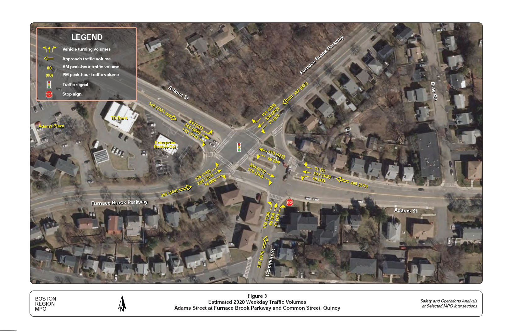
Figure 3 summarizes the estimated 2020 AM and PM peak-hour traffic turning volumes and pedestrian crossing volumes by approaches at the two study intersections. The estimation represents normal traffic conditions in 2020, not the conditions during the COVID-19 crisis.
The intersection of Adams Street at Furnace Brook Parkway is estimated to carry approximately 2,000 to 2,200 entry vehicles per peak hour under the normal traffic conditions. In general, traffic is more prevailing in the directions toward Interstate 93 in the morning and toward Quincy Center in the evening. Each of the approaches carries about 400 to 600 vehicles per peak hour, except the Adams Street eastbound that could carry over 750 vehicles in the PM peak hour. All approaches have a high proportion of left-turning traffic, especially the parkway northbound and Adams Street eastbound. Each could carry about 150 left-turn vehicles per peak hour. Meanwhile, the parkway southbound could carry nearly 200 right-turning vehicles in the AM peak hour and Adams Street generally has about 120 right-turning vehicles per peak hour.
The intersection of Adams Street at Common Street is estimated to carry approximately 1,200 to 1,400 entry vehicles per peak hour under normal traffic conditions. The estimation indicates that Common Street carries about 300 vehicles per peak hour in the morning and about 250 vehicles per peak hour in the evening.
The intersection turning movement counts, conducted in the extended four-hour peak periods in the weekday morning and evening and Saturday midday, provide three different sets of pedestrian and bicycle counts:
The data indicate that the intersection of Adams Street at Furnace Brook Parkway carried significant pedestrian volumes during the weekday AM and PM peak hours on a fair weather autumn day. In the AM peak hour (7:30–8:30 AM), there were a total of 25 pedestrian crossings and three bicycle crossings. In the PM peak hour (4:45–5:45 PM), there were a total of 76 pedestrian crossings and five bicycle crossings. The counts by approaches indicate that all the four crosswalks at the intersection were fairly utilized.
In the AM peak period (6:00–10:00 AM), there were 73 pedestrian crossings and three bicycle crossings in the intersection. In the PM peak period (2:00–6:00 PM), there were 132 pedestrian crossings and 27 bicycle crossings. During the peak period (10:00 AM–2:00 PM) on Saturday (October 3, 2020), there were 56 pedestrian crossings and 16 bicycle crossings.
There were a smaller number of pedestrian and bicycle crossings at the intersection of Adams and Common Streets. In the AM peak hour (7:30–8:30 AM), there were a total of 16 pedestrian crossings and one bicycle crossing. In the PM peak hour (4:45–5:45 PM), there were a total of 29 pedestrian crossings and no bicycle crossings. Most people crossed the intersection at the crosswalk on Common Street and some crossed the right-turn channel on Adams Street westbound. During peak AM and PM hours, there were one and three persons crossing Adams Street where no crosswalks exist. Though Adams Street is wide, the traffic medians provide a refuge for these crossings.
The counts also show that a significant number of people bicycled through the intersection of Adams Street at Furnace Brook Parkway. In the AM peak hour (7:30–8:30 AM), two bicyclists went through the intersection and one turned right on the parkway southbound. In the PM peak hour (4:45–5:45 PM), there were two right-turning bicyclists and one who traveled through on Adams Street eastbound and four right-turning bicyclists on Furnace Brook Parkway southbound.
Figure 3
Estimated 2020 Weekday Traffic Volumes
Adams Street at Furnace Brook Parkway and Common Street, Quincy
The counts confirm that Furnace Brook Parkway is a popular bike route. In the AM peak period (6:00–10:00 AM), the parkway carried 10 and Adams Street carried four bicycles. In the PM peak period (2:00–6:00 PM), the parkway carried 26 and Adams Street carried 19 bicycles. In the Saturday (October 9, 2020) peak period (10:00 AM–2:00 PM), the parkway carried 36 and Adams Street carried 16 bicycles. On the parkway the directional split was fairly even, but it appears that there were more bicycles traveling on Adams Street eastbound in all the peak periods.
Common Street generally carries a smaller number of on-road bicycles. At the intersection, the northbound approach carried five bicycles toward the intersection in the AM peak period, no bicycles in the PM peak period, and 11 bicycles in the Saturday peak period.
Traffic studies usually apply the observed or estimated 85th percentile speeds to assess how fast vehicles are traveling at a specific location on a roadway. The 85th percentile speed is the speed at or below which 85 percent of vehicles passing a given point are traveling, and it is the principal value used to establish speed controls by the state. It can be regarded as the prevailing vehicle speed on the roadway adjacent to the study location.
The ATR counts that staff requested for this study include spot speed estimates at the count locations. Based on the counts, MassDOT estimated the 85th percentile speeds at the following three locations:
The data indicate that people generally traveled much faster than the posted speed limits in the vicinity of the study intersections, probably due to the wide travel lanes. Appendix G summarizes the percentages of the travel speed ranges by five mph increments at the three locations. Note that the 85th percentile speeds estimated from the ATR counts cannot be directly used for modification of the existing speed regulation. 7
Based on the estimated 2020 AM and PM peak-hour turning movements, staff conducted the intersection capacity analysis for the two study intersections by using the Synchro traffic analysis and simulation program.8
Staff conducted traffic operations analyses consistent with the Highway Capacity Manual (HCM) methodologies (included in Appendix C). HCM methodology demonstrates driving conditions at signalized and unsignalized intersections in terms of level-of- service (LOS) ratings from A through F. LOS A represents the best operating conditions (little to no delay), while LOS F represents the worst operating conditions (very long delay). LOS E represents operating conditions at capacity (limit of acceptable delay). Table 3 presents the control delays associated with each LOS for signalized and unsignalized intersections.
Table 3
Intersection Level of Service Criteria
Level of Service |
Signalized Intersection Control Delay (Seconds per Vehicle) |
Unsignalized Intersection Control Delay (Seconds per Vehicle) |
A |
0–10 |
0–10 |
B |
> 10–20 |
> 10–15 |
C |
> 20–35 |
> 15–25 |
D |
> 35–55 |
> 25–35 |
E |
> 55–80 |
> 35–50 |
F |
> 80 |
> 50 |
Source: Highway Capacity Manual 2010.
Table 4 summarizes the estimated LOS, average delay, and volume to capacity ratio (V/C) for all the approaches at the intersection in the AM and PM peak hours. The estimation was based on an observed cycle length of 129 seconds that consists of 46 seconds (40-second green, plus six-second yellow, and all-red clearance time) for Adams Street approaches, 56 seconds (50-second green, plus six-second yellow, and all-red clearance time) for Furnace Brook Parkway approaches, and 27 seconds for the exclusive pedestrian signal phase.
The evaluation revealed that intersection of Adams Street at Furnace Brook Parkway operated at acceptable LOS overall.9 However, some individual approaches operated at an undesirable LOS. The parkway southbound was estimated to operate at LOS F with average delay of nearly one and half minutes in the AM peak hour and the Adams Street eastbound was estimated to operate at LOS E with average delay of about one minute in the PM peak hour.
At the unsignalized intersection, the stop-controlled Common Street approach operated at LOS F with average delay of about one minute in both the AM and PM peak hours.
Appendix H contains detailed Synchro reports of the AM and PM intersection capacity analysis for the two intersections. Note that the analysis does not completely reflect some congested conditions, such as left-turn blockages on Furnace Brook Parkway and the usually congested short section of Adams Street westbound between Furnace Brook Parkway and Common Street during the peak hours. However, the conditions were present in the traffic simulations of the Synchro models.
Table 4
Summary of Intersection Capacity Analyses
Estimated 2020 AM and PM Peak-Hour Traffic Conditions
Intersection Approach |
Lane Group |
AM |
AM |
AM |
95th Queue |
PM |
PM |
PM |
95th Queue |
Adams Street EB |
L/T/R |
D |
38 |
0.68 |
320 |
E |
63 |
0.98 |
#552 |
Adams Street WB |
L |
D |
37 |
0.36 |
99 |
D |
40 |
0.31 |
61 |
Adams Street WB |
T/R |
C |
30 |
0.35 |
203 |
C |
30 |
0.38 |
214 |
Furnace Brook Parkway NB |
L/T |
D |
43 |
0.78 |
#451 |
D |
41 |
0.78 |
#534 |
Furnace Brook Parkway NB |
R |
A |
8 |
0.11 |
38 |
A |
9 |
0.13 |
50 |
Furnace Brook Parkway SB |
L/T/R |
F |
84 |
1.07 |
#771 |
D |
39 |
0.81 |
#661 |
Intersection (1) Average |
- |
D |
52 |
- |
- |
D |
45 |
- |
- |
Adams Street EB |
T/R |
A |
0 |
0.18 |
- |
A |
0 |
0.26 |
- |
Adams Street WB |
L |
A |
9 |
0.05 |
4 |
A |
8 |
0.05 |
4 |
Adams Street WB |
T/R |
A |
0 |
0.15 |
- |
A |
0 |
0.15 |
- |
Common Street NB |
L/T/R |
F |
69 |
0.95 |
263 |
F |
51 |
0.86 |
203 |
Intersection (2) Average |
- |
C |
19 |
- |
- |
B |
11 |
- |
- |
Notes:
Intersection (1) is Adams Street at Furnace Brook Parkway. Intersection (2) is Adams Street at Common Street.
The figures for AM and PM delay represent the average seconds of delay per vehicle.
Locations where the 95th percentile volume exceeded capacity are indicated by the number sign (#). The queue shown is the maximum after two cycles,
EB = eastbound. L = left turn. LOS = level of service. NB = northbound. SB = southbound. R = right turn.
T = through movement. V/C = volume-to-capacity ratio. WB = westbound.
Source: Central Transportation Planning Staff.
Based on the above analyses, MPO staff developed a series of short- and long-term improvements to address safety and operational problems at the intersections. The proposed short-term improvements generally can be implemented within two years at a relatively low cost (usually under $30,000). The proposed long-term improvements are more complicated and cover larger areas, thus require intensive planning and design, and significant funding. These improvements are analyzed in the next section. The proposed short-term improvements are summarized below, from the lowest to the highest cost:
Clearly define on-street parking spaces on Adams Street westbound near Common Street and prohibit parking near the intersection.
The proposed long-term improvements would require intensive planning, design, and funding. Staff developed four improvement alternatives for the two intersections and the immediate area around them, based on the goals of maximizing safety and operational benefits for all transportation modes and minimizing land-taking and construction impacts.
Staff also analyzed traffic operations for the alternatives and the base case (no-build scenario) under the projected 2030 traffic conditions. For comparison purposes, the analysis included a future year no-build scenario that contained only improvements involving signal retiming with no geometry modifications and no upgrade to the signal system.
Key elements of the no-build scenario and the four alternatives are summarized as below.
The no-build alternative assumes that the intersection would remain the same as the existing conditions with no intersection layout modifications and no upgrade to the signal system. The only improvement included was the retiming of the signal with the existing signal phasing sequence and a slight increase of overall cycle length.
Alternative 1 proposes to reconstruct both intersections, and upgrade signals at the parkway intersection. Figure 4 shows the conceptual plan of the alternative. Key elements of the alternative include
Alternative 2 proposes to reconstruct both intersections, upgrade signals at the parkway intersection, and signalize the Common Street intersection under the same controller. The alternative would require a similar layout to Alternative 1 (see Figure 5 for the conceptual plan). Key elements of the alternative include
Alternative 3 proposes to reconstruct both intersections, upgrade signals at the parkway intersection, and prohibit traffic from Common Street crossing Adams Street in both directions. Figure 6 shows the conceptual plan for the alternative. Key elements of the alternative include
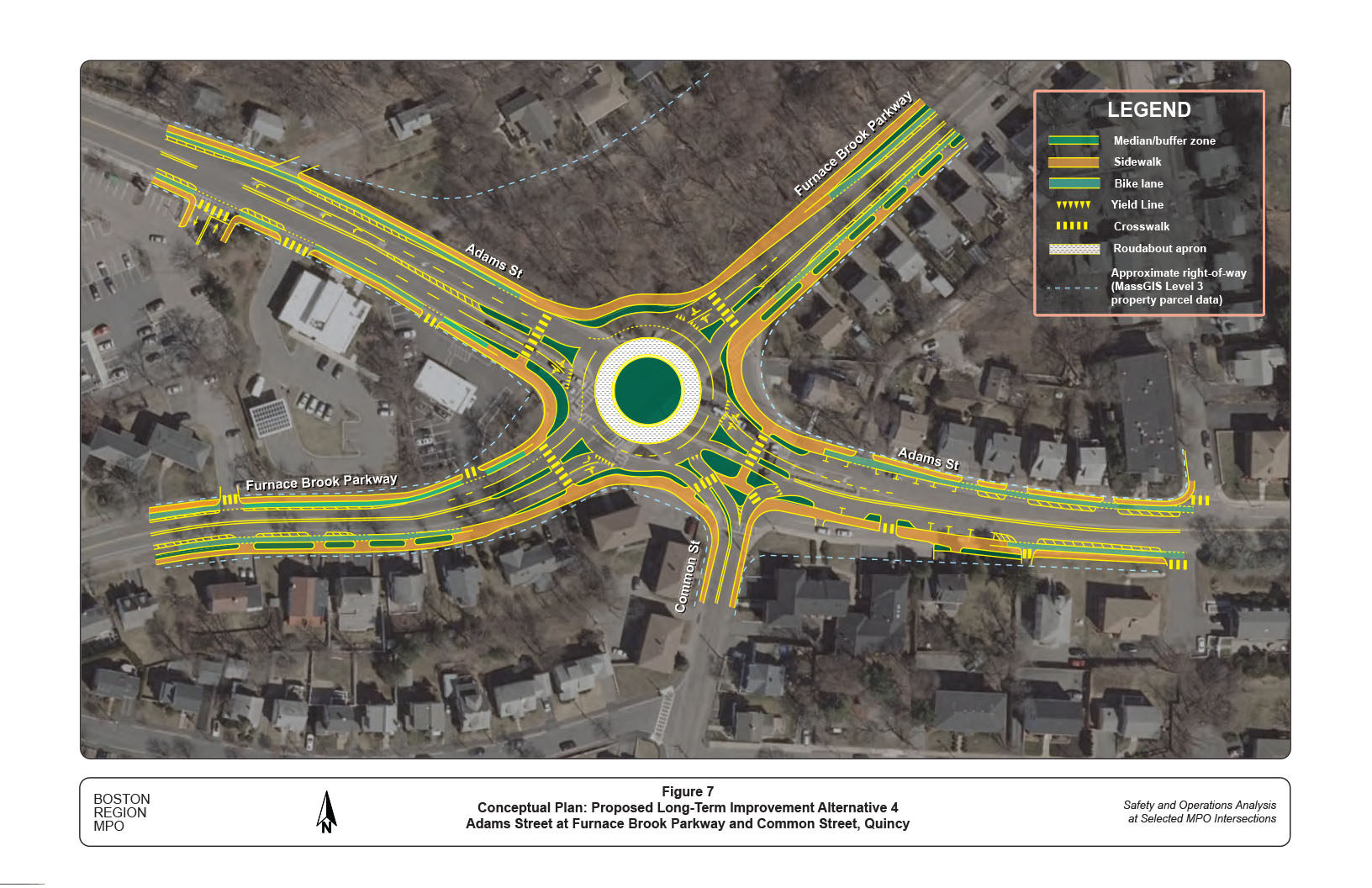
Alternative 4 proposes to convert the two intersections into a double-lane modern roundabout. Figure 7 shows the conceptual plan of the alternative. Key elements of the alternative include
Figure 4
Proposed Long-Term Improvement Alternative 1
Adams Street at Furnace Brook Parkway and Common Street, Quincy

Figure 5
Proposed Long-Term Improvement Alternative 2
Adams Street at Furnace Brook Parkway and Common Street, Quincy
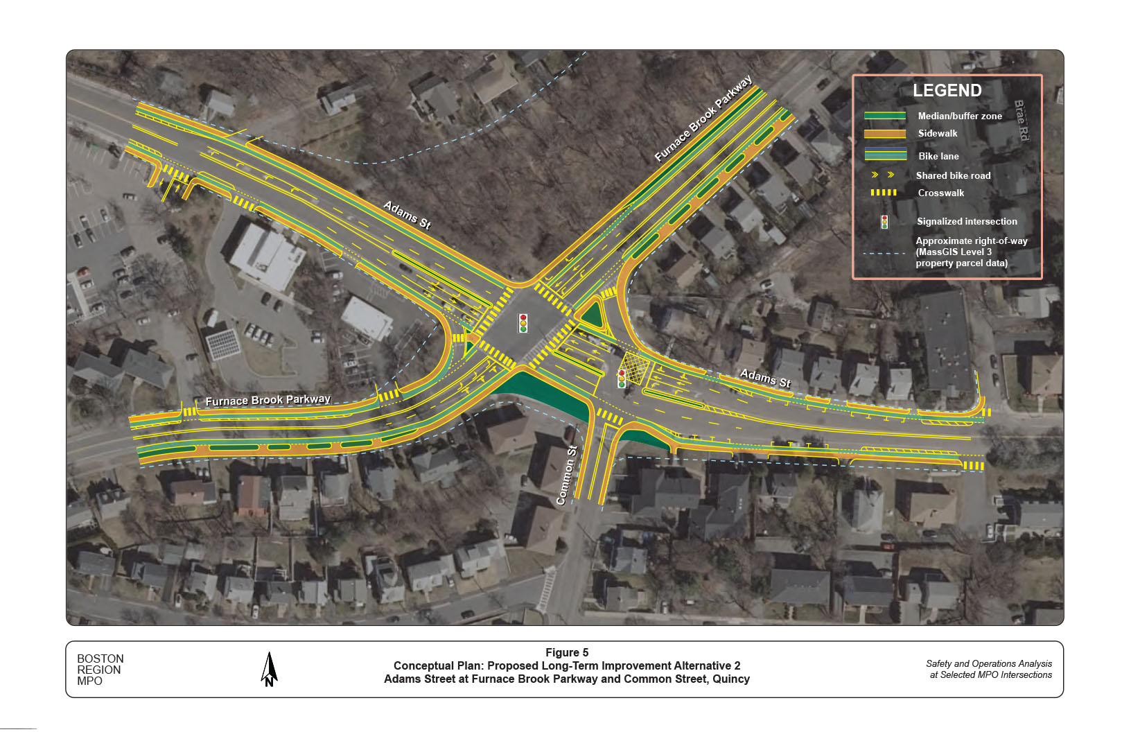
Figure 6
Proposed Long-Term Improvement Alternative 3
Adams Street at Furnace Brook Parkway and Common Street, Quincy

Figure 7
Proposed Long-Term Improvement Alternative 4
Adams Street at Furnace Brook Parkway and Common Street, Quincy
Staff conducted the intersection capacity analyses for the no-build scenario and the four alternatives under the forecasted 2030 AM and PM peak-hour traffic conditions.28 Appendix J contains a series of tables that summarize the capacity analysis results and Synchro reports that include input volumes, lane configurations, signal-timing settings, estimated delays and 95th percentile queue lengths by approaches for the no-build scenario and the four alternatives.
The analyses indicate that all the four alternatives would operate at acceptable levels of services in both the AM and PM peak hours. They would improve traffic operations over the no-build scenario and improve safety for all the users of the intersections.
Note that the capacity analyses do not explicitly indicate the safety benefits of the four alternatives. The addition of left-turn lanes in Alternatives 1, 2, and 3 would reduce left-turn crashes and reduce the severity of crashes. In addition, these alternatives would improve safety for pedestrians and bicyclists by shortening crossing distance and adding sidewalks and bicycle accommodation and detection. Among them, Alternative 3 would change the traffic patterns in the area and have significant impacts to the neighborhoods on Common Street and Furnace Brook Parkway.29 This alternative and these issues should be further discussed and examined at the functional design stage.
Alternative 4 (modern roundabout conversion) would significantly slow down the traffic at the intersection and reduce the severity of crashes. It would require two circulatory lanes and a much larger footprint than Alternatives 1, 2, and 3.30 Meanwhile, pedestrians and bicyclists would need to take longer and indirect paths to cross the roundabout. Due to the high traffic volumes and the significant number of pedestrian and bicyclist crossings, further examination should be done to determine if traffic signals are required at the crosswalk locations.
This study performed a series of safety and operations analyses, identified issues and concerns, and proposed short- and long-term improvements at the intersection. The proposed short-term improvements would enhance safety and operations for the intersection under the existing conditions. With a relatively high benefit/cost ratio, these improvements should be implemented as soon as resources are available from highway maintenance or local Chapter 90 funding.
The proposed long-term improvements—such as reconstructing the two intersections by adding necessary turning lanes, installing sidewalks, crosswalks and bicycle accommodations, and renovating the signal system to include count-down pedestrian assessable signals and bicycle detection—would significantly address the safety and operational problems at both intersections. At this preliminary planning stage, staff consider all alternatives feasible.
Staff presented the study findings and proposed improvement alternatives to the City of Quincy and MassDOT on February 11, 2021, via ZOOM video conference. The City considered the long-term improvement Alternatives 2 and 4 more favorable than the other alternatives and suggested that variations of the modern roundabouts (Alternative 4), such as an ellipse or a “peanut” shape roundabout, should be further examined at the design stage. (See Appendix K for the comments from the City.)
DCR has jurisdiction of the intersection of Adams Street at Furnace Brook Parkway and the City of Quincy has jurisdiction of the intersection of Adams Street at Common Street. This study gives the City an opportunity to address the needs of both intersections and plan for design and engineering.
The next steps would be to advance the project through the planning process to the functional design stage and select the preferred alternative that meets the goals and needs of all stakeholders, including residents and business owners. These steps will depend upon cooperation between the City, DCR, and MassDOT, which can begin the project notification and review process and complete the project initiation form. After completing a preliminary design, preferably an approved 25-percent functional design, the City can submit the project for inclusion in the Boston Region MPO’s Transportation Improvement Program. Project development is a complicated process that takes transportation improvements from concept to construction and is influenced by factors such as financial limitations and agency programmatic commitments. (See Appendix L for an overview of this process.)
This study supports the MPO’s visions and goals, which include increasing transportation safety, maintaining the transportation system, advancing mobility and access, reducing congestion, and expanding the opportunities for walking and bicycling, while making these activities safer. If implemented, the improvements proposed in this report would modernize the roadway and significantly improve safety and mobility of all users. As with all conceptual level studies and recommendations, a further more detailed engineering examination should be conducted before implementing any of this study’s recommendations.
cc: Allison Ruel, City of Quincy
Makaela Niles, MassDOT Office of Transportation Planning
Appendices
The Boston Region Metropolitan Planning Organization (MPO) operates its programs, services, and activities in compliance with federal nondiscrimination laws including Title VI of the Civil Rights Act of 1964 (Title VI), the Civil Rights Restoration Act of 1987, and related statutes and regulations. Title VI prohibits discrimination in federally assisted programs and requires that no person in the United States of America shall, on the grounds of race, color, or national origin (including limited English proficiency), be excluded from participation in, denied the benefits of, or be otherwise subjected to discrimination under any program or activity that receives federal assistance. Related federal nondiscrimination laws administered by the Federal Highway Administration, Federal Transit Administration, or both, prohibit discrimination on the basis of age, sex, and disability. The Boston Region MPO considers these protected populations in its Title VI Programs, consistent with federal interpretation and administration. In addition, the Boston Region MPO provides meaningful access to its programs, services, and activities to individuals with limited English proficiency, in compliance with U.S. Department of Transportation policy and guidance on federal Executive Order 13166. The Boston Region MPO also complies with the Massachusetts Public Accommodation Law, M.G.L. c 272 sections 92a, 98, 98a, which prohibits making any distinction, discrimination, or restriction in admission to, or treatment in a place of public accommodation based on race, color, religious creed, national origin, sex, sexual orientation, disability, or ancestry. Likewise, the Boston Region MPO complies with the Governor's Executive Order 526, section 4, which requires that all programs, activities, and services provided, performed, licensed, chartered, funded, regulated, or contracted for by the state shall be conducted without unlawful discrimination based on race, color, age, gender, ethnicity, sexual orientation, gender identity or expression, religion, creed, ancestry, national origin, disability, veteran's status (including Vietnam-era veterans), or background. A complaint form and additional information can be obtained by contacting the MPO or at http://www.bostonmpo.org/mpo_non_discrimination. To request this information in a different language or in an accessible format, please contact Title VI Specialist |
1 Details of the selection process and criteria may be found in the Central Transportation Planning Staff’s (CTPS) technical memorandum, “Safety and Operation at Selected Intersections: Federal Fiscal Year 2020,” Chen-Yuan Wang November 7, 2019.
2 Locations eligible for Highway Safety Improvement Program (HSIP) funding are defined by MassDOT as crash clusters that rank within the top five percent of crash clusters for each regional planning agency, based on the Equivalent Property Damage Only (EPDO) index. In the EPDO index, crashes resulting in property damage only and crashes in which the severity is unknown are awarded one point each, fatal crashes and crashes involving injuries are given 21 points each. In the Boston Region MPO area, 421 intersections are identified from MassDOT 2014–16 crash data as the top five percent crash clusters with a minimum EPDO value of 115.
3 “Left-turn crash” refers to a crash that involves at least one left-turning vehicle.
4 The crosswalks on Adams Street are about 75 to 80 feet long and the crosswalks on Furnace Brook Parkway are about 50 to 55 feet long.
5 Governor Baker's COVID-19 Order #5, which prohibited gatherings of more than 25 people, was issued on March 15, 2020.
6 The entire ATR data set for this study can be obtained from the MassDOT Interactive Traffic Volume and Classification Map (also known as Transportation Data Management System) at Massachusetts government webpage https://www.mass.gov/traffic-volume-and-classification.
7 To establish or modify speed controls, MassDOT requires the collection of speed data by radar gun or laser gun at critical locations at intervals not to exceed 0.25 miles, in addition to vehicle trial runs in the study area.
8 Staff used Synchro Version 10.3, developed and distributed by Trafficware Ltd. It can perform capacity analysis and traffic simulation (when combined with SimTraffic) for an individual intersection or a series of intersections in a roadway network.
9 For the intersections in a metropolitan urban area, LOS A, B, and C are considered desirable; LOS D and E are considered acceptable; and LOS F is considered undesirable.
10 Appendix I contains the intersection capacity analyses based on the estimated 2020 normal traffic volumes. The analyses indicate that an adjustment to the signal timing for both roadway approaches by slightly increasing the cycle length by six seconds would notably reduce delays and traffic queue lengths at the intersection, especially in the AM peak hour.
11 The backplates and retroreflective borders would be effective by increasing drivers’ awareness of the signal presence and by reducing solar glare. However, the existing signal post foundations may not be strong enough to support the additional weight. Their positions and effectiveness need to be further examined.
12 The right-turn channel carries a relatively low volume, allows fast right-turn movements, and inconveniences pedestrians when crossing.
13 The space for adding the left-turn lane can be obtained by reducing the width of the traffic median on Adams Street. The intersection capacity analysis with the 2030 traffic projections indicate that it would require a storage length of at least 100 feet.
14 The intersection capacity analysis indicates that the right-turn lane would require a storage length of about 150 feet and the left-turn lane would require a storage length of 50 to 75 feet.
15 The left-turn lane should have a storage length of about 150 feet.
16 The existing signals are post-mounted. The posts should be replaced by mast arms. The signal heads should be designed and positioned according to traffic operations and the intersection layout and equipped with backplates and retroreflective borders.
17 The intersection capacity analysis indicates that it would require a storage length of about 100 feet.
18 The right-turn lane would require a storage length of about 150 feet and the left-turn would require a storage length of 50 to 75 feet.
19 The left-turn lane should have a storage length of about 150 feet.
20 In this alternative, traffic signals would operate with protected left turns and pedestrian signals would operate in concurrent phases with through traffic movements.
21 The left-turn should have a storage length of about 100 feet.
22 The right-turn lane should have a storage length of about 150 feet and the left-turn should have a storage length of 50 to 75 feet.
23 The intersection capacity analysis indicates that the left-turn lane would require a storage length of about 200 feet.
24 The right-turn channel mainly serves traffic from Common Street and carries only about five to 10 vehicles per hour from Adams Street. The removal would provide more comfortable access and crossing at the intersection for people who walk and bike.
25 The Synchro HCM 6th roundabout analysis indicates that a single-lane roundabout would not be feasible under the projected 2030 traffic conditions.
26 The right turns at the roundabout would not be feasible because of the entry angle of the Common Street approach.
27 According to the MassDOT Guidelines for Planning and Design of Roundabouts (published September 2020), bicyclists are always offered the option of traveling through a roundabout as a vehicle. However, at locations with planned or existing bicycle facilities on the roundabout approaches, bicyclists are provided with additional options for navigating the roundabout, such as by continuing biking on a share-use path (10 feet minimal) or walking their bike as a pedestrian on a sidewalk (at constrained locations less than 10 feet wide).
28 Staff estimated that the intersection would have about five percent traffic growth (about 0.5 percent per year) in the AM peak hour and six percent traffic growth (about 0.6 percent per year) in the PM peak hour from 2020 to 2030, based on analysis of the historical counts and consideration of traffic growth at Quincy Center.
29 Presumably, most of the traffic using Common Street as a cut-through route would switch back to Furnace Brook Parkway. Common Street neighborhoods would benefit from reduced traffic, although the residents may also need to take a longer path to reach the north and west of the intersection. In the capacity analysis of Alternative 3, this study assumed that all the northbound through and left-turn movements on Common Street would divert to the Furnace Brook Parkway northbound approach. The analysis indicates that the northbound approach would have longer traffic queues and require about 50 feet more left-turn storage than Alternatives 1 and 2.
30 As shown in Figure 7, MassGIS Level 3 standardized assessors’ parcel data indicate that the roundabout could potentially be constructed without taking lands from adjacent private properties.