MEMORANDUM
Introduction
Braintree Station, located at 197 Ivory Street, in Braintree, was selected to be included in the Boston Region Metropolitan Planning Organization (MPO) Safe Access to Transit for Pedestrians and Bicyclists Study. This study examines nonmotorized accessibility issues related to Braintree Station and identifies short- and long-term measures that can significantly improve pedestrian and bicyclist access to the Massachusetts Bay Transportation Authority (MBTA) system. Braintree Station was selected based on the following factors:
- Identified as needing improvements according to a qualitative MBTA station access assessment.
- Located in an area with a high density of employment, retail activity, and/or population.
- Located in an area with a high crash rate for vehicles, pedestrians, and/or bicyclists.
- Of the large number of passengers boarding or alighting at Braintree (almost 4,400 on an average weekday), only about 13% walk or bike and 5.7% use an MBTA bus to access the station or to travel from the station to their destinations. This is relatively low in comparison to other stations along the Braintree Branch of the Red Line.
- There are over 1,300 parking spaces for motor vehicles, 22 of which are accessible, at a rate of $7.00 per day and $8.00 for overnight parking. Parking is consistently at capacity (99% utilization).
- There are 80 bike parking spaces at this station, including a new Pedal & Park bike cage, yet only 30 bikes were parked at the station during a site visit.
- The local municipality has shown an interest in improving pedestrian and bicycle access to the station.
- There is future development potential.
Transportation Context
Braintree Station is the southern terminus of the MBTA Red Line heavy rail line. Braintree Station was constructed in 1980 as part of a concept to extend the existing transit lines into the expanding suburbs and have suburban commuters drive to and park at convenient rapid transit stations. This concept has proven to be successful, since parking at Braintree Station has a 99% utilization rate. Overflow illegal parking for Braintree Station is occurring in the shopping center parking lots south of the station, as well as in the residential neighborhood located west of Braintree Station, which is a concern of both town officials and local businesses.
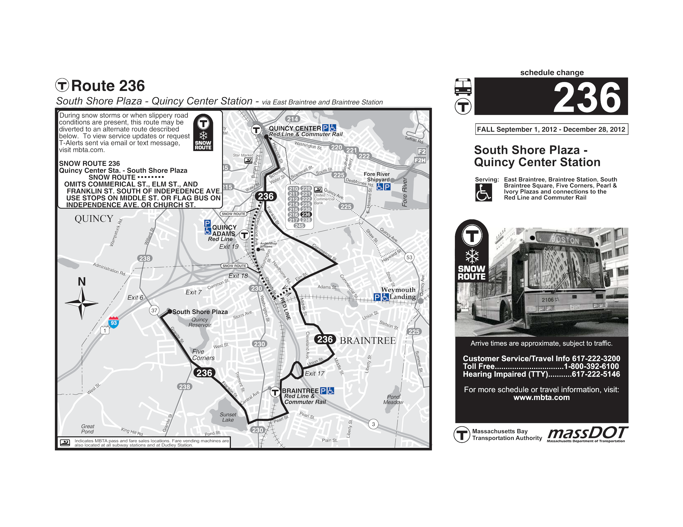
To the east of Braintree Station, there are access ramps to Route 3/Pilgrims Highway via a large roundabout. Route 3/Pilgrims Highway connects to Interstate 93 to the north. The Red Line shares the MBTA rail corridor with the Kingston/Plymouth commuter rail line. There is a stop for this commuter rail line at Braintree Station. Other public transportation services provided at Braintree Station include MBTA bus Routes 230 and 236. Route 230 provides service between the town of Holbrook and the MBTA’s Quincy Center Station. Route 230 travels along Washington Street, which parallels the Red Line rail corridor to the east. Route 236 provides service between the South Shore Plaza Shopping Center and the MBTA’s Quincy Center Station. Route 236 travels along Ivory Street, which parallels the Red Line rail corridor to the west. The average weekday boardings and alightings for these bus routes at Braintree Station are provided in Table 1. Maps for Route 230 and Route 236 are provided in the Appendix.
Table 1
Average Weekday Boardings and
Alightings at Braintree Station
|
Inbound |
Outbound |
Bus Route |
On |
Off |
On |
Off |
230 |
56 |
284 |
258 |
84 |
236 |
22 |
66 |
71 |
25 |
There are three major shopping centers owned by Messina Enterprises that lie to the south of Braintree Station. The shopping centers, primarily consisting of big box retailers, are bordered to the west by the rail corridor. Harvard Vanguard Medical Associates, a large employer in the area, is also located to the north of Braintree Station. Jonathans Landing, a recently constructed housing development with approximately 700 owner-occupied units, is located on the east side of John W. Mahar Highway, south of Ivory and Pearl streets. There is a town-owned solid waste transfer station along the east side of Ivory Street, between Union and Pearl streets. There are several public buildings located along Washington Street near Union Street, including the Town Hall, a public library, a fire station, and French’s Common, which is a public park. The town center is located at the intersection of Washington and Pearl streets, which is a little over a half mile from Braintree Station. There are two schools located within a half mile of Braintree Station; Thayer Academy, with 681 students, and St. Francis Assisi, with 350 students.
Intersection Safety
Identifying Problem Intersections
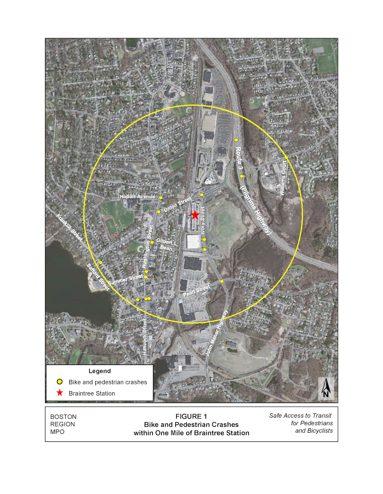
Records available to Boston Region MPO staff show that there have been a total of 16 crashes involving a bicycle or pedestrian from 2005 to 2009 within one mile of Braintree Station (Table 2). Figure 1 illustrates the locations of the bicycle and pedestrian crashes in proximity to Braintree Station, as well as showing the roadways in the vicinity.
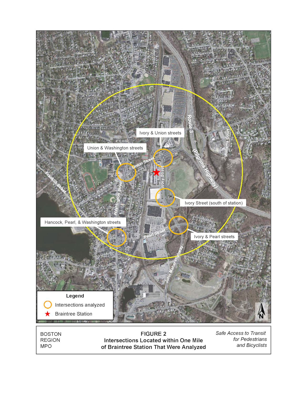
Based on their crash data and proximity to Braintree Station, the four major intersections closest to Braintree Station were selected for further analysis. The majority of pedestrians and bicyclists accessing Braintree Station travel through at least one of these intersections. The intersections on Ivory Street south of Braintree Station at the two access driveways for the shopping center were also selected for further analysis, since there was one pedestrian crash at each of these locations. The selected intersections, depicted in Figure 2, are:
- Ivory Street and Union Street – 62 crashes total, including one involving a pedestrian
- Ivory Street (south of Braintree Station) – 2 crashes involving a pedestrian
- Ivory Street and Pearl Street – 47 crashes total, including one involving a pedestrian
- Hancock Street, Pearl Street, and Washington Street – 24 crashes total, including three involving pedestrians
- Union Street and Washington Street – 19 crashes total, including one involving a pedestrian
Table 2
Intersections within One Mile of Braintree Station with
Pedestrian or Bicycle Crashes from 2005 to 2009
Intersection |
City/Town |
Vehicle Crashes |
Pedestrian Crashes |
Bicycle Crashes |
Total Crashes |
Ivory Street/Union Street |
Braintree |
62 |
1 |
0 |
63 |
Ivory Street (south of station) |
Braintree |
0 |
2 |
0 |
2 |
Ivory Street/ Pearl Street |
Braintree |
47 |
1 |
0 |
42 |
Hancock Street/Pearl Street/Washington Street |
Braintree |
24 |
3 |
0 |
27 |
960 Washington Street |
Braintree |
0 |
2 |
0 |
2 |
Summer Street at Washington Street |
Braintree |
4 |
1 |
0 |
5 |
Union Street/Washington Street |
Braintree |
19 |
1 |
0 |
20 |
Hobart Avenue/Washington Street |
Braintree |
3 |
1 |
1 |
5 |
Gilbert L. Bean Drive/Washington Street |
Braintree |
9 |
0 |
1 |
10 |
Franklin Street/Safford Street |
Braintree |
8 |
1 |
0 |
9 |
Union Street/Williams Court |
Braintree |
2 |
1 |
0 |
2 |
Intersection Analysis
This section describes the existing conditions and recommended improvements for the five identified problem intersections. The description of existing conditions is based on a site visit conducted on Friday, August 24, 2012, during the morning. Recommended improvements are either short- or long-term in nature and are developed in order to help alleviate the concerns and issues identified during the site visit. Short-term improvements would primarily consist of the installation of signs and pavement markings, which may be implementable within a short time frame with local resources. Long-term improvements would require more capital-intensive roadway construction, which would necessitate the identification and allocation of resources and would entail a longer implementation schedule.
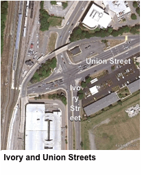 Ivory and Union Streets
Existing Conditions
There were 62 crashes, including one with a pedestrian, at the intersection of Union Street and Ivory Street, which is located northeast of Braintree Station. This intersection is signalized on all approaches. Union Street, which is under the jurisdiction of the Town of Braintree, has four travel lanes, runs in an east-west direction, and is classified as an urban minor arterial. As Union Street approaches Ivory Street from the west, there are two straight through lanes, one left-turn lane, one right-turn lane, and no on-street parking. As Union Street approaches Ivory Street from the east, there is one right-turn-only lane, one lane that is a right-turn/through lane, one left-turn/through lane, one-left turn-only lane, and no on-street parking.
Ivory Street, which is under the jurisdiction of the Town of Braintree, has four travel lanes, runs in a north-south direction, and is classified as a local road. Ivory Street has right-turn lanes separated by channelizing islands on both approaches to Union Street. The channelizing island on the southbound approach is also a pedestrian refuge island. There is no on-street parking. High volumes of cars and trucks and moderate speeds were observed along both Union and Ivory streets during the site visit.
 The west and north legs of the intersection of Ivory and Union streets have ladder-style crosswalks. The west leg also has pedestrian signals and pedestrian curb-cut ramps, although the ramps do not have detectable warning pads. The west leg has two pedestrian refuge islands with curb cuts, and pedestrian signals that create a three-step crossing (stopping at two islands in the roadway). The crossing distance between the southwest corner and the first island is approximately 64 feet. The pedestrian signal timing provided when the push button on the southwest corner is activated is 19 seconds; however, when the push button is activated from the first island, the pedestrian signal timing is 17.5 seconds. Based on a walking speed of 3.5 seconds per foot, the minimum pedestrian signal timing for a crossing distance of 64 feet is 18.3 seconds. The crossing from the second island to the northwest corner is not signalized, since there are channelized right-turn movements from southbound Ivory Street onto westbound Union Street.
The north leg of this intersection does not have a pedestrian signal and the ramps do not have detectable warning pads. The lack of a pedestrian signal combined with a crossing distance of approximately 75 feet creates an unsafe environment for pedestrians. The longest uninterrupted crossing a pedestrian should encounter at a crosswalk is 50 feet.6
There is an almost-exclusive pedestrian phase for all legs of the intersection; channelized right-turn movements are allowed during that phase.
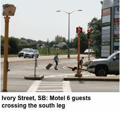
There are no crosswalks provided on the east and south legs of this intersection. There is a Motel 6 located on the southeast corner of this intersection that creates a demand for a signalized and marked crossing for the south leg. During the site visit, several Motel 6 guests were observed crossing the south leg while traveling to and from Braintree Station, oftentimes while pulling luggage.
There is a sidewalk along the south side of Union Street to the west of Ivory Street that is approximately 8 feet in width and in fair condition. There are sidewalks on the west side of Ivory Street north and south of the intersection and along the north side of Union Street east of Ivory that are approximately 7 feet in width and in good condition. There is no sidewalk along the north side of Union Street west of this intersection, or along the south side of Union Street east of this intersection. There is a worn path in the grass along the north side of Union Street west of this intersection, which demonstrates a demand for a sidewalk at this location. This may be a result of Thayer Academy students taking the most direct path to and from Braintree Station.
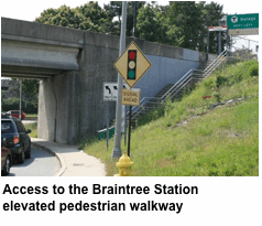 There is an elevated pedestrian walkway that connects Braintree Station to the commercial properties north of Union Street. Access to the walkway for the commercial properties is provided by a steep staircase that is not fully accessible and that has only one “Braintree Station” sign, at the top of the stairs.
There are no bicycle-specific features at this intersection, and there are several large potholes in the road on the south side of Union Street between Ivory and Washington streets.
Recommended Improvements
The following short-term measures are recommended for improving safety for the various right-of-way (ROW) users at this intersection:
Pedestrian Improvements:
- Increase the pedestrian signal timing for the push button located in the middle island on the west leg to 19 seconds, which would meet the minimum timing requirements and would also be consistent with the push buttons along the west leg.
- Upgrade to accessible pedestrian signals with countdown features.
- Install ADA-compliant detectable warning pads on all pedestrian curb-cut ramps.
Install directional signage in advance of the staircase leading to the elevated pedestrian walkway, as well as at the station platform in advance of the walkway, in order to encourage MBTA passengers traveling to and from the commercial area north of Braintree Station to use the walkway rather than crossing at the intersection of Ivory and Union streets.
Bicycle Improvements:
- Install “share the road” signage along Union Street to increase motorists’ awareness of the presence of bicyclists.
- Repair potholes on the south side of Union Street west of this intersection and ensure that pavement adjacent to curbs along all roadways is in good condition, without any potholes, bumps, or longitudinal drain grates.
- Encourage businesses to install bike racks for their customers.
The following long-term measures are recommended for improving safety for the various ROW users at this intersection:
Pedestrian Improvements:
- Stripe a ladder-style crosswalk along the south leg of this intersection. Ladder crosswalks are more visible than simple parallel lines, especially at night or in low-light conditions. This would require constructing a pedestrian landing at the southeast corner of Union and Ivory streets with pedestrian access to Motel 6, construction of curb-cut ramps through the channelizing island, and installation of an accessible pedestrian signal with countdown features. The pedestrian signal should not interfere with the traffic signal timing, since this intersection has an almost-exclusive pedestrian phase.
- Install a new, accessible pedestrian signal head with countdown features at the northeast corner of this intersection to improve safety for pedestrians crossing along the north leg.
- Make the MBTA stairway and elevated pedestrian walkway accessible.
- If redevelopment occurs near this intersection, evaluate ROW widths to determine if a sidewalk could be constructed along the north side of Union Street to the west of this intersection. This would accommodate a more direct path for Thayer Academy students traveling to and from Braintree Station.
Bicycle Improvements:
- If redevelopment occurs near this intersection, evaluate ROW widths for the inclusion of bike facilities along Union Street, from Washington Street to west of the roundabout. This would improve bicycle access to the station for the residential areas located east and west of Braintree Station.
- Ensure adequate lighting along Union Street.
 Ivory Street (South of Braintree Station)
Existing Conditions
There were two crashes involving pedestrians along Ivory Street south of Braintree Station. During the site visit, traffic volumes and speeds were moderate, and a large number of trucks were observed, many of which were accessing the transfer station. Bus Route 236 operates along Ivory Street, with stops at the intersection of Ivory and Pearl streets. There is a sidewalk along the west side of Ivory Street that is approximately 6 feet in width and in good condition. There is no sidewalk along the east side of Ivory Street.
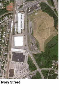
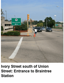
The entrance to Braintree Station, located on the west side of Ivory Street south of Union Street, has three lanes delineated for the egress, although no lanes are delineated for the ingress. The width of the entrance is approximately 90 feet, separated by a median approximately 6 feet in width. This entrance does not have a crosswalk and the median does not have curb cuts.
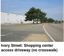
 There are two access driveways to the shopping center along the west side of Ivory Street between Union and Pearl Streets. The southern access driveway has a crossing distance of approximately 90 feet, a stop sign, stop bar, and crosswalk. The northern access driveway has no crosswalk and has a crossing distance of approximately 75 feet.
As previously stated, overflow parking for Braintree Station is occurring in the shopping center parking lot located to the south of Braintree Station. Passengers parking here are taking the most direct route to the station, which is through the parking lots rather than along the sidewalk. The west side of Ivory Street between Union and Pearl streets has a 6-foot sidewalk with minimal shade trees and no amenities such as benches or garbage cans.
 The Braintree Transfer Station, located at 257 Ivory Street, creates an unwelcoming environment for pedestrians due to odor and noise. The transfer station is currently undergoing renovations that will improve aesthetics, help control odor, and reduce noise pollution. The renovations will also include access improvements, which will reduce the queue of trucks. These renovations will improve the environment along Ivory Street for pedestrians.
There are no bicycle-specific features at this intersection. Bicyclists were observed riding along the sidewalk on the east side of Ivory Street.
Recommended Improvements
The following short-term measures are recommended for improving safety for the various ROW users at this intersection:
Pedestrian Improvements:
- Stripe a ladder-style crosswalk and a stop bar at the access driveway to the north of Dunkin’ Donuts. This would better delineate the vehicle egress route and increase visibility between motorists and pedestrians.
- Install ADA-compliant detectable warning pads on all pedestrian curb-cut ramps.
- Plant shade trees along the west side of Ivory Street to provide a more comfortable walking environment for pedestrians.
Bicycle Improvements:
- Install “share the road” signage along Union Street to increase motorist awareness of the presence of bicyclists.
- Ensure that pavement adjacent to curbs along all roadways is in good condition, without any potholes, bumps, or longitudinal drain grates.
The following long-term measures are recommended for improving safety for the various ROW users at this intersection:
Pedestrian Improvements:
- Widen the existing sidewalk on the west side of Ivory Street, plant shade trees, and install benches, garbage cans, and other pedestrian amenities to improve the walking environment along this corridor in order to encourage pedestrians to walk on sidewalks along the street rather than cutting through the parking lots.
- At the access driveway to the north of Dunkin’ Donuts, extend the sidewalk in order to reduce the pedestrian crossing distance.
- Stripe a ladder-style crosswalk and construct a curb cut through the median on the west leg of the intersection of Ivory Street and the MBTA entrance.
Bicycle Improvements:
- Construct a shared-use path along the east side of Ivory Street from Pearl Street to Union Street. Issues of odor and noise associated with the Braintree Transfer Station should be mitigated as a result of the renovation project, making the ROW along the east side, which is owned by the Town of Braintree, usable for bicycle and pedestrian use. A shared-use path would improve pedestrian and bicyclist access between Braintree Station and the residential areas located southwest of Braintree Station, such as Jonathans Landing. This would also require crosswalks to be striped along the north, south, and east legs of Ivory Street at the entrance to Braintree Station. The median on the north leg should be improved so that it can be used as a pedestrian refuge island. The installation of MBTA directional signage would encourage users of the proposed shared-use path to cross at this intersection.
- Ensure adequate lighting along Ivory Street.
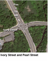 Ivory Street and Pearl Street
Existing Conditions
There were a total of 47 crashes, including one involving a pedestrian, between 2005 and 2009 at the intersection of Ivory Street and Pearl Street. Pearl Street, which is under the jurisdiction of the Town of Braintree, has two travel lanes, runs in an east-west direction, and is classified as an urban collector road. This intersection is signalized. There is on-street parking on both sides of Pearl Street west of the rail corridor underpass. As Pearl Street approaches Ivory Street from the west, there is one shared through/right lane and one left-turn lane. As Pearl Street approaches Ivory Street from the east, there is one through lane and one right-turn-only lane. During the site visit, moderate traffic volumes and speeds were observed. Ivory Street becomes John W. Mahar Highway south of Pearl Street. John W. Mahar Highway is classified as a local road and is under the jurisdiction of the Town of Braintree. As John W. Mahar Highway approaches Pearl Street from the south, there are two through lanes. There is a speed feedback sign installed for northbound traffic on John W. Mahar Highway near the entrance to Jonathans Landing.
The south, west, and north legs of the intersection have ladder-style crosswalks and audible pedestrian signals, where pushing a button results in an exclusive pedestrian phase. The pedestrian signals do not have countdown features. The pedestrian signal head on the southwest corner of this intersection does not light up when activated. The crossing distances for the three legs that have crosswalks ranges from 75 to 81 feet. In general, the longest uninterrupted crossing a pedestrian should encounter at a crosswalk is 50 feet. There are pedestrian curb-cut ramps at each crosswalk location, although they lack detectable warning pads.
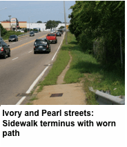 There is no crosswalk on the east leg of the intersection, since the sidewalk on the northeast corner of the intersection terminates on the approach to Ivory Street. After the sidewalk terminates, there are signs of pedestrian activity from a worn path in the grass leading up to the entrance of the Braintree Transfer Station. At this point, the strip of grass becomes very narrow and there is a fence blocking further access. This forces pedestrians to cross Ivory Street at an unmarked and unsignalized location. This pedestrian activity may be a result of the proximity of Jonathans Landing, which has approximately 700 owner-occupied units, as well as from the residential area located southwest of Braintree Station.
There are no bicycle-specific features at this intersection. Bicyclists were observed riding along both the sidewalk and in the roadway along Pearl Street. The Braintree Townwide 10-Year Transportation Management Plan recommends considering restriping John W. Mahar Highway from Pearl Street to Plain Street to one through lane in each direction and intermittent left-turn lanes in each direction. Since the existing pavement width is approximately 50 feet, there may be sufficient width for two 4-foot shoulders, which could be used by bicyclists. This would also improve pedestrian crossing distances, since only three lanes of traffic would need to be crossed instead of four.
Recommended Improvements
The following short-term measures are recommended for improving safety for the various ROW users at this intersection:
Pedestrian Improvements:
- Install MBTA wayfinding signs on the northeast and southeast corners of Ivory Street, Pearl Street, and John W. Mahar Highway directing pedestrians to cross over Ivory Street and John W. Mahar Highway for access to Braintree Station.
- Repair the pedestrian signal head on the southwest corner of this intersection.
- Upgrade the pedestrian signal heads with countdown features.
- Install ADA-compliant detectable warning pads on all pedestrian curb-cut ramps.
Bicycle Improvements:
- Stripe shared-lane markings (for bikes and motor vehicles) with “Bicycles May Use Full Lane” (MUTCD R4-11) signs along Pearl Street from Washington Street to Ivory Street. The Town of Braintree may also consider striping shared-lane markings east of Ivory Street to Liberty Street in order to improve bicycle access for the residential area located southwest of Braintree Station. This residential area is within two miles of Braintree Station.
- Ensure that the pavement adjacent to curbs along all roadways is in good condition, without any potholes, bumps, or longitudinal drain grates.
The following long-term measures are recommended for improving safety for the various ROW users at this intersection:
Pedestrian Improvements:
- Construct curb extensions at the corners of this intersection where there is sufficient width. Curb extensions would help to reduce pedestrian crossing distances, make pedestrians more visible to motorists, and provide traffic calming.
Bicycle Improvements:
- Create a more comfortable environment for bicyclists by calming traffic along John W. Mahar Highway through measures such as the aforementioned curb extensions, as well as through other measures, such as textured crosswalks.
- Consider implementing the recommendations provided in the Braintree Transportation Management Plan for restriping John W. Mahar Highway between Pearl and Plain streets in order to accommodate two 4-foot paved shoulders, which would be used by bicyclists.
Ensure adequate lighting along Pearl Street and John W. Mahar Highway.
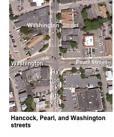 Hancock, Pearl and Washington Streets
Existing Conditions
There were 24 crashes in total, including three involving pedestrians, between 2005 and 2009 at the intersection of Hancock, Pearl, and Washington streets. Washington Street, which is under the jurisdiction of the Town of Braintree, has two travel lanes, runs in a north-south direction, and is classified as an urban minor arterial. Washington Street approaches from the north and becomes Hancock Street south of the intersection. Pearl Street approaches from the east and becomes Washington Street west of the intersection. This intersection is signalized at all approaches. Both the north and south approaches have right-turn lanes and both the east and west approaches have left-turn lanes. During the site visit, moderate traffic volumes and speeds were observed.
All legs of this intersection have ladder-style crosswalks and pedestrian activated signals, where pushing a button results in an exclusive pedestrian phase. The pedestrian signal head on the northeast corner does not light up when activated. The crossing on the west leg has a pedestrian refuge island and a total crossing distance of approximately 72 feet, with a pedestrian signal timing of 19 seconds. Based on a walking speed of 3.5 seconds, the minimum pedestrian signal timing for a crossing distance of 72 feet is 21 seconds. The sidewalks throughout the intersection are in good condition. All corners of the intersection have pedestrian curb-cut ramps, although the ramps do not have detectable warning pads.
There are no bicycle-specific features at this intersection. During the site visit, bicyclists were observed riding in the roadway along Washington Street.
Recommended Improvements
The following short-term measures are recommended for improving safety for the various ROW users at this intersection:
Pedestrian Improvements:
- Repair the pedestrian signal head on the northeast corner of Washington, Pearl, and Hancock Streets.
- Increase the pedestrian signal timing to 21 seconds.
- Upgrade to accessible pedestrian signals with countdown features.
- Install ADA-compliant detectable warning pads on all pedestrian curb-cut ramps.
Bicycle Improvements:
- Stripe shared-lane markings with “Bicycles May Use Full Lane” (MUTCD R4-11) along Washington Street from Pearl Street to Elm Street. This would improve bicycle access for the residential area located to the west and northwest of Braintree Station. These residential areas are located within two miles of the station. It would also improve bicycle access for residents wishing to bike to the public facilities located along Washington Street, such as the town hall, library, and park, and to Braintree’s town center, which is located at the intersection of Hancock, Pearl, and Washington streets, as well as for students biking to Thayer Academy or to the Saint Francis of Assisi School.
- Ensure that pavement adjacent to curbs along all roadways is in good condition, without any potholes, bumps, or longitudinal drain grates.
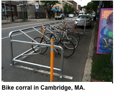
 Install bike racks within the public ROW and encourage businesses to install bike racks for their customers. A potential location for bicycle racks would be in the public seating area located on the west side of Washington Street, south of Pearl Street. Another option is to install a bike corral in an on-street parking space. Bike corrals are appropriate for town centers and commercial areas where there is a high demand for bike parking, and can accommodate up to 14 bikes within one stall.
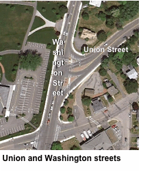
Union and Washington Streets
Existing Conditions
There were 19 crashes in total, including one involving a pedestrian, between 2005 and 2009 at the intersection of Union and Washington streets. Washington and Union streets meet at a signalized, skewed “T” intersection. As Union Street approaches Washington Street from the east, there are two left-turn lanes and one continuous right-turn lane. As Washington Street approaches Union Street from the north, there is one through lane and one right-turn lane. As Washington Street approaches from the south, there are two through lanes and one channelized right-turn lane. During the site visit, traffic volumes and speeds appeared to be moderate along all of the intersecting roadways.
The east and north legs of this intersection have ladder-style crosswalks. The crosswalk on the east leg has a crossing distance of approximately 127 feet, broken up by two pedestrian refuge islands. There are pedestrian-activated signals only between the two islands, and none for the continuous right-turn lanes. The crosswalk on the north leg has pedestrian-activated signals. Activating the pedestrian signals results in a concurrent pedestrian phase. The pedestrian signal timing is sufficient for the lengths of crossings at this intersection.
The sidewalks are approximately 6 feet in width and in good condition throughout the intersection. All corners of the intersection have pedestrian curb-cut ramps, although the ramps do not have detectable warning pads. There appears to be adequate lighting along Washington Street, provided by pedestrian-scale light posts. There are no bicycle-specific features at this intersection.
Recommended Improvements
The following short-term measures are recommended for improving safety for the various ROW users at this intersection:
Pedestrian Improvements:
- Upgrade to accessible pedestrian signals with countdown features.
- Install a “State Law – Yield to Pedestrians” sign on the same pole used for the existing pedestrian warning sign, which serves the crosswalk for the channelized right-turn lane for northbound traffic on Washington Street. This would emphasize the need for right-turning motorists to yield to pedestrians.
 Install ADA-compliant detectable warning pads on all pedestrian curb-cut ramps.
- Bicycle Improvements:
- Stripe shared-lane markings with “Bicycles May Use Full Lane” (MUTCD R4-11) along Washington Street from Pearl Street to Elm Street.
Install bike racks within the public ROW near entrances to public buildings and facilities, such as at the Town Hall, the library, and French’s Common.
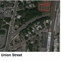 Union Street
Existing Conditions
The section of Union Street, from Washington Street to Ivory Street has two lanes in the eastbound direction and one lane that widens to two lanes, approximately 300 feet before the intersection, in the westbound direction. There is a sidewalk provided along the southern side of Union Street that has numerous cracks and problem sidewalk panels near the intersection.
On the northern side, the sidewalk ends at the corner of Washington Street and Union Street. However a path has been worn by pedestrians from the end of the sidewalk to where the bridge abutment begins. Pedestrians then cross Union Street to the southern sidewalk; crossing midblock, where there is no crosswalk.
This section of Union Street provides a key pedestrian access way to and from the station and the two schools located opposite Union Street, west of Washington Street. The current access to and from the schools is along the sidewalk on the southern side of Union Street, under the MBTA bridge, which has numerous bird droppings and dripping water from the bridge above, to a stairwell leading to the station.
The following short-term measures are recommended for improving safety for the various ROW users:
Pedestrian Improvements:
- Repair sidewalk cracks and broken panels near Washington Street.
 The following long-term measures are recommended for improving safety and improving station access for Union Street pedestrians:
Pedestrian Improvements:
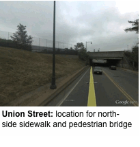
- Construct a new sidewalk on the northern side of Union Street from continuing from where it currently ends, at the Washington Street intersection.
- Construct a pedestrian bridge from the end of the new sidewalk on the north side, and over the train tracks, to the existing pedestrian walkway that leads from the Union Street and Ivory Street intersection to the station. The grade changes of the terrain would help with the approach to the new pedestrian bridge over the train tracks. (Another option that was examined was adding pedestrian bridge at the end of Union Place. This option would not be as likely to improve access for Union Street pedestrians and would also likely attract more kiss-and-ride users along Union Place, which is a residential street.
Building on Safety: A New Access Vision
The recommendations provided in this study aim to improve accessibility to Braintree Station from surrounding neighborhoods for pedestrians and bicyclists. If implemented, these recommendations would provide pedestrians and bicyclists with safer and more convenient paths to Braintree Station.
The recommendations are either short-term, low-cost, and quick to implement, or are long-term and would require a more intensive capital investment with a longer implementation schedule. Short-term improvements recommended in this study include striping crosswalks, installing bicycle, pedestrian, and MBTA signage, installing ADA-compliant improvements, repairing malfunctioning pedestrian signals, repairing or maintaining pavement where necessary, and striping shared-lane markings. These types of improvements would improve visibility between pedestrians, bicyclists, and motorists, indicate where these users should travel within the ROW, and provide a safer and more convenient environment.
The long-term improvements recommended in this study include striping new crosswalks, which would require constructing curb cuts and other pedestrian features, constructing curb extensions for traffic calming, improving ADA compliance by making the elevated MBTA pedestrian walkway accessible, extending sidewalks, installing pedestrian signals, constructing a shared-use path, ensuring adequate lighting throughout the corridor, and constructing a new pedestrian bridge over the train tracks. These types of improvements would more effectively increase visibility between pedestrians, bicyclists, and motorists, as well as helping to reduce vehicle speeds and minimize crossing distances for pedestrians, than the short-term improvements.
This study recommends establishing a network of bike routes along the roads leading to Braintree Station. These proposed bike routes, which may include shared-lane markings, shared-use paths, and “share the road” signage, would improve access and connectivity between Braintree Station and the residential areas located within two miles of this station. It would also improve connectivity between these residential areas and Braintree’s town center, public facilities, and several major shopping centers. It is recommended that during future roadway reconstruction projects, the Town of Braintree evaluate ROW widths in order to determine if separated bicycle facilities, such as cycle tracks, shared-use paths, and buffered bike lanes, could be accommodated along the proposed bike routes. These types of bike facilities provide a safer environment for bicyclists than facilities where bicyclists and motorists share the roadway.
The Braintree Townwide 10-Year Transportation Management Plan, which includes two locations in and near the study area, also provides recommendations for bicycle and pedestrian improvements. The location in the study area is on John W. Mahar Highway at Pearl Street, where it is recommended to reduce the number of travel lanes in order to accommodate left turn lanes and paved shoulders. The location near the study area is at Union Street and Route 3, where it is recommended to provide grade separated crossings for bicyclists and pedestrians.
Implementing the recommendations in this study would improve the roadways used by pedestrians and bicyclists accessing Braintree Station. This may encourage more users of Braintree Station to choose bicycling and walking as modes of transportation, and may also promote the use of public transit. This, in turn, may shift users from personal vehicles, which may also help reduce the strain on commuter parking at Braintree Station, which is consistently at capacity (99% utilization). Reducing the demand for parking at Braintree Station is a more cost-effective solution than constructing additional parking spaces. Overall, through the implementation of these recommendations, the Town of Braintree would improve access to safe, healthy, efficient, and varied transportation options for its residents and visitors.
MSA/CB/cb
APPENDIX
Maps of MBTA Bus Routes
Route 230
Route 236
General Recommendations
General Recommendations
Overall, none of the study locations have issues that seriously impede the access of pedestrians and bicyclists to a transit station. However, general maintenance issues should be addressed in all of the study areas. In addition, conditions and facilities could be further improved in order to enhance the safety and quality of pedestrian or bicyclist access; best-practices guidelines should be consulted and applied when possible.
Maintenance of Existing Facilities and Amenities
In each of the study areas, many of the existing facilities and amenities are in need of repair or upkeep. Faded crosswalk paint, uneven and broken pavement surfaces on sidewalks and roadways, malfunctioning pedestrian signals, and malfunctioning streetlamps are examples of facilities and amenities that are in need of attention. At a minimum, these should be in good, functional condition.
Seasonal Maintenance
Another condition commonly found at many study locations is a need for regular and seasonal upkeep of sidewalks and roadways. Dirt, sand, and debris accumulate in the gutters of roads and on sidewalks, particularly during and after the winter season. The winter also presents the issue of snow and ice, which are often piled onto sidewalks and along the sides of roads. In the summer, weeds and overgrown plants can obstruct pedestrian and bicyclist movement. Aside from being unpleasant and a nuisance, these conditions create obstructions that may make travel hazardous and impede transit patrons from easily using the MBTA system.
Sidewalks
It is important to provide a continuous and accessible network of sidewalks along walking routes to MBTA stations, particularly for pedestrians with disabilities. When a sidewalk is provided on only one side of a roadway, pedestrians often walk in the street or cross at unmarked midblock locations. Sidewalk surfaces should be level, smooth, and without obstructions in the pathway of pedestrians. In addition, best-practices guidelines recommend a buffer between the sidewalk and the roadway. However, on most of the streets in the study areas, roadway widths may not permit this feature.
In a few locations, the sidewalks do not have a curb-cut wheelchair ramp at crosswalks. Also at some locations, sidewalks have diagonal (apex) curb ramps, where only one ramp is provided at a street corner; these ramps typically are not aligned with the marked crosswalks. Diagonal curb ramps are the predominant type used in the study areas; however, this type of curb ramp is not recommended by current Federal Highway Administration best-practices guidelines. Instead, street corners should have two curb ramps, one aligned with one street’s crosswalk and the other aligned with the other street’s crosswalk (see the diagram at the left). For additional safety, the bottom of the ramps should have a detectable warming strip.
Crosswalks

The crosswalks in the study areas generally are striped with basic markings, very few of which are marked in a manner that goes above and beyond the Manual on Uniform Traffic Control Devices (MUTCD) standards. Typically, they are striped with two parallel solid white lines or have a ladder-style marking. In most cases, the stop line for vehicle traffic is too close to the crosswalk.
Best-practices guidelines recommend that crosswalks be well marked and accentuated by curb extensions. This study recommends, at a minimum, marking sidewalks with ladder-style striping. A 10-foot distance between the stop lines and crosswalks is recommended. Treatments for multilane roadways should include a 10-to-30-foot distance between the stop line and the crosswalk, pedestrian refuge islands/medians, and curb extensions for increased visibility of pedestrians. Also, this study recommends appropriate signs to warn motorists of pedestrian crossing activity.
In order to improve sight lines between motorists and crossing pedestrians, on-street parking should be spaced at least 30 feet back from crosswalks. Furthermore, other innovative options for enhancing crosswalks should be considered, including the use of reflective paint or thermoplastic striping, pavement texturing (see photo, at left), in-pavement lights, crosswalk cones and barrels, and overhead signs.

Signalized Pedestrian Crosswalks
 Some signalized pedestrian crossings in the study area have malfunctioning signals and buttons. As a first step, all existing signals should have functioning buttons and walk signals. Moreover, the crossings should be enhanced with more modern signal technology. For example, signals should be equipped with pedestrian activation buttons that light up when pushed, as an indication of having been successfully activated. Also, countdown-style pedestrian crossing signals (see photo, at left) should be used in places with a sufficient amount of pedestrian activity to warrant them.
Intersection Safety
 Several intersections in the study areas should be made safer for pedestrians and bicyclists through some minor redesign. (An example of a possible redesign is shown in a photo below, from the website www.pedbikeimages.org/DanBurden.) Curb extensions at the corners, for instance, create a tighter turning radius for vehicles, which slows the speed of traffic at turns. Curb extensions also provide better sight lines for motorists to watch for pedestrians and vice versa. Furthermore, medians and islands can be enlarged to better guide and control traffic, often slowing vehicle speeds as well. Medians and traffic islands should be large and visible enough to provide sufficient refuge for pedestrians. Plus, striping should be clear and delineate the vehicle turning lanes, the crosswalks, and the stop lines. Lastly, intersections with significant pedestrian activity could be marked as a pedestrian crossing zone (instead of having only crosswalks), where an all-red pedestrian phase is part of the signal cycle.
On-Street Bicycling
On many roads that lead to transit stations, bicyclists must contend with high traffic volumes and on-street parking. High traffic volumes, particularly when combined with high speeds and frequent turning movements, can be intimidating to bicyclists. Traffic-calming measures that reduce vehicle speeds can be implemented to help reduce both the severity and incidence of motor vehicle crashes with bicycles, and can also make bicyclists feel more comfortable while riding along roadways. On-street parking poses challenges in the form of conflicts between vehicles that are parking or discharging passengers, and bicyclists, who are often negotiating traffic to their left in addition to coping with the parked-vehicle activity to their right.
Roadway design and condition are also issues for bicyclists. Narrow lanes and narrow shoulders are a concern, particularly on roads with high traffic volumes. Potholes and poor pavement should be fixed, as bicyclists are more sensitive to pavement conditions than are motorists. Storm-sewer grates should be either grids or parallel bars appropriately placed perpendicular to traffic flow.
There are different types of on-street bicycle facilities that can be provided to improve safety for bicyclists, such as cycle tracks, buffered bike lanes, bike lanes, shared lanes, paved shoulders, and signed routes. Further study of the availability of right-of-way, roadway conditions and bicycle traffic volumes should be conducted in order to determine the type of on-street bicycle facility that would be appropriate for a specific roadway.
Bicycle Parking
All of the stations studied provide bicycle racks. When selecting locations for the installation of bicycle racks, it is important to consider visibility, lighting conditions, protection from the elements, and proximity to destinations. Additionally, racks should be situated in spots that offer enough space not only for storing bicycles, but also for maneuvering them. If bicycle racks or cages are located in an area not easily seen by bicyclists, then directional signage should be considered.
Current bicycle parking guidelines recommend that providers of bicycle racks select types that:
- Support the bicycle upright by its frame in two places, enabling the frame and one or both wheels to be secured
- Allow both front-in and back-in parking
- Are compatible with today’s bike frames and with U-locks
 Common styles of bicycle parking racks that meet the above guidelines include: the inverted-U or hoop (see photo to left), “A” (a hoop with a horizontal bar), and post-and-loop (also known as bike hitch). Many manufacturers produce these or acceptable variations of these styles. These rack elements are typically arranged in a row or array; the spacing between the rack elements should be a minimum of 30 inches (on centers), but preferably a more comfortable 36 to 42 inches.
Signs: Wayfinding for Transit Stations
Well-placed wayfinding signs—pointing the way to a transit station—reach out to potential riders. They are similar in function to signs that direct motorists to highway ramps. Care should be taken to install the signs at a height and orientation favorable to pedestrians. Also, these signs should use conventional MBTA symbols, lettering, and colors.
Travel Environment
The aesthetic look and feel of the travel environment can encourage use by pedestrians and bicyclists. Communities should implement measures to improve the quality of the street environment through the use of landscaping (trees, shrubs, and flowers, all appropriately placed), lighting, furniture (such as benches and trashcans), and artwork (such as sculptures and murals). Chambers of commerce and business owners should also be encouraged to enhance storefronts and streetscapes.
Future Considerations
The opportunity to implement many of the recommended improvements may only arise when a roadway construction project occurs. Any roadway construction project should apply best-practices guidelines for serving pedestrian and bicyclist travel in general. More specifically, projects should improve walk and bike access to transit stops and stations as much as possible. In essence, the MBTA, the MassDOT Highway Division, local governments, and land developers should coordinate and cooperate on all transportation improvement projects to ensure that pedestrian and bicyclist needs are integrated into the final designs.
When improvements are made to the accessibility of transit for pedestrians and bicyclists, they can be highlighted in public information campaigns promoting the option of bicycling to transit stations. The improved accessibility can be extolled, along with the cost, time, and health benefits to individuals.