Technical Memorandum
DATE: January 18, 2018
TO: Boston Region Metropolitan Planning Organization
FROM: Seth Asante, MPO Staff
During the development of the Boston Region Metropolitan Planning Organization (MPO) Long-Range Transportation Plan (LRTP), Charting Progress to 2040, the MPO staff identified the existing needs for all transportation modes in the region.1 The results were compiled in the LRTP Needs Assessment, which is used to guide the MPO’s decision-making process for selecting transportation projects to fund in future Transportation Improvement Programs (TIP). The MPO goals that guided the development of the LRTP Needs Assessment include the following:
Based on previous and ongoing transportation-planning work—including the MPO’s Congestion Management Process (CMP) and planning studies—MPO staff identified several priority arterial roadway segments that require maintenance, modernization, and safety and mobility improvements. These locations are documented in the LRTP Needs Assessment.
To address problems on some of these arterial segments, the Addressing Priority Corridors from the Long-Range Transportation Plan Needs Assessment study was included in the federal fiscal year (FFY) 2018 Unified Planning Work Program (UPWP).2 This memorandum presents the results of Task 2 of the work program for that study.3 Task 2 involves presenting a recommendation for locations to study to the MPO board for discussion.
By focusing on arterial segments rather than intersections, planners can evaluate multimodal transportation needs comprehensively (with the goal of creating Complete Streets). A holistic approach to analyzing problems and forming recommendations ensures that the needs of all public transportation users—including pedestrians, bicyclists, and motorists—are considered. Ultimately, this approach will result in roadways where it is safe to cross the street and walk or cycle to shops, schools, train stations, and recreational facilities, and where buses can run on time. Typically, the recommended improvements are within a roadway’s right-of-way. They take into account the needs of abutters and users, and the interests and support of stakeholders.
The process for selecting study locations consisted of three steps. First, MPO staff assembled data about the arterial segments identified in the LRTP Needs Assessment and used the data to prioritize the roadway segments. Next, MPO staff examined the arterial segments more closely by applying specific criteria. Finally, staff scored each arterial segment and assigned a priority of low, medium, or high to each segment. Details about each step in the process are provided below.
MPO staff identified 44 arterial segments in 33 municipalities in the Boston region based on the following data sources:
Table 1 (attached) presents the data and information gathered on each of the following arterial segments:
Table 1 also includes the score and priority rating that were determined by applying the selection criteria. The processes for scoring and assigning priority ratings to segments are described below.
MPO staff examined the arterial segments more closely by applying the following six criteria and assigning points based on the number of criteria that apply to each location:
MPO staff rated arterial segments with a total score of 10 or fewer points as low priority; those with a score of 11 to 12 points as medium priority; and those with a total score of 13 or more points as high priority. MPO staff gave 15 arterial segments a high-priority rating based on safety and operational needs, multimodal and regional significance, regional equity, and support for improvements from agencies and municipalities. Staff then examined high-priority segments more closely, and excluded arterials that had projects meeting any of the following criteria from further consideration for this cycle of the Priority Corridors study: recently completed, in construction, in design, under study, or programmed in the TIP with the 25 percent design completed.
The four arterial segments with the highest scores were:
Staff also evaluated the pedestrian accommodation and safety improvement needs for these segments by applying the MPO’s recently developed Pedestrian Report Card Assessment.4 All four locations highly qualify based on pedestrian accommodation or safety improvement requirements. Appendix A contains detailed results of the assessments. Based on this evaluation, MPO staff recommends studying the segment on Route 138 in Milton.
The arterial segment that was selected for study was Route 138 in Milton, based on a total score of 14, using the five selection criteria (safety, congestion, multimodal and regional significance, regional equity, and implementation potential). Route 138 runs north-south through Milton, from the border of Boston to the north to the border of Canton to the south. In Milton, the roadway primarily passes through residential areas and the Blue Hills Reservation area. Current evaluation indicates that there are safety, capacity, and mobility problems in the segment. Two locations along the segment contain HSIP-eligible crash clusters and the segment has a higher-than-average crash rate for its functional class. The corridor also sees a high injury rate with 39 percent of collisions causing injuries. Additionally, several intersections in the segment are congested, which create long traffic queues during peak travel periods. Finally, accommodations for pedestrians and bicyclists are poor and need improvement—several sections in the Blue Hills Reservation and Curry College lack sidewalks.
The Town of Milton is considering capacity and mobility improvements in the corridor and has expressed support for and willingness to participate in a study of this arterial segment (See Appendix B). MassDOT Highway Division District 6 supports this study and asked the MPO staff to identify the problems and develop Complete Street solutions that could be implemented by MassDOT in tandem with a future roadway improvement project.
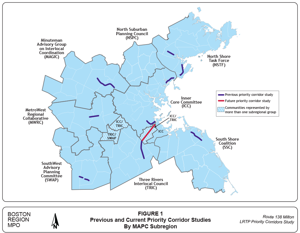
The recommended arterial segment on Route 138 in Milton meets the selection criteria of this study, especially by supporting the transportation improvement priorities of the MPO’s LRTP. While the work program for this study assumed that “as many as two” arterial segments would be selected, the MPO staff does not propose studying a second arterial segment because Route 138 in Milton is approximately 3.5 miles long and this study would require considerable resources for evaluating alternative improvement plans. Figure 1 shows the general locations of previous Priority Corridor studies, and the location identified for this year’s study.
After the MPO board discusses this recommendation, staff will meet with officials from the Town of Milton, MassDOT, MAPC, and other stakeholders to discuss the study specifics, conduct field visits, collect data, identify needs, and develop solutions.
SA/sa
1 Boston Region Metropolitan Planning Organization, Charting Progress to 2040: The New Long-Range Transportation Plan of the Boston Region Metropolitan Planning Organization, endorsed by the Boston Region MPO on July 30, 2015.
2 Boston Region Metropolitan Planning Organization, Unified Planning Work Program, Federal Fiscal Year 2018, endorsed by the Boston Region Metropolitan Planning Organization on June 15, 2017 and was approved by our federal partners and took effect on October 1, 2017.
3 Karl H. Quackenbush, CTPS Executive Director, memorandum of a work program to the Boston Region Metropolitan Planning Organization, “Addressing Priority Corridors from the Long-Range Transportation Plan Needs Assessment: Federal Fiscal Year (FFY) 2017,” October 19, 2017.
4 Ryan Hicks and Casey-Marie Claude, Boston Region Metropolitan Organization, Pedestrian Level-of-Service Memorandum, January 19, 2017.
Figure 1
Previous and Current Priority Corridor Studies by MAPC Subregion
Table 1
Arterial Segments Considered for Study: Priority Corridors for Long-Range Transportation Plan Needs Assessment Study (Arterial Segment Selected for Study Is Highlighted in Green)
| Community | MAPC Subregion | MassDOT District | Jurisdiction | National Highway System | Functional Class* | Crash Rate (MVMT) | Number of Top-200 High-Crash Locations 2012–14 | Number of HSIP-Eligible Crash Clusters 2012–14** | Travel-Time Index | Transit Service | Crowded or Late Bus | In or Near Environmental Justice Zone | Study, Project, or TIP Project | Safety Conditions | Congested Conditions | Multimodal Significance | Regional Significance | Regional Equity | Implementation Potential | Score | Priority Rating | Summary of Comments |
| Milton | ICC and TRIC | 6 | MassDOT | Yes | 2 | 1.5 | 0 | 1 | 2.41 | MBTA bus Routes 245 and 716 MBTA Commuter Rail at Route 128 Station MBTA Red Line Rapid Transit at Mattapan Station |
Yes | Yes Half of the segment is contained within EJ zones. |
MassDOT Poject #608484, Roadway Improvement on Route 138, project is planned to be funded through the 2020 Transportation Improvement Program for the Boston Metropolitan Planning Organization (MPO); project will also incorporate work planned originally for 607763 (described below); in the preliminary design phase. MassDOT Project #607763, Intersection and Signal Improvements at Two Locations: Route 138 (Blue Hill Avenue) at Atherton Street and Bradlee Road and Route 138 (Blue Hill Avenue) at Milton Street and Dollar Lane, programmed in federal fiscal year (FFY) 2019 Transportation Improvement Program (TIP); in the preliminary design phase. |
2 | 2 | 2 | 4 | 1 | 3 | 14 | High | Safety and congestion issues have been identified on this route and many locations in the segment need pedestrian and bicycle improvements. In addition, several intersections in the segment have congestion and safety issues. The Town of Milton is looking at pedestrian improvements in the corridor and has expressed unanimous support for the study. MassDOT Highway District 6 is in support of this study to identify problems and solutions that can be implemented in tandem with a future roadway improvement project in the segment. The location was suggested in the 2017 MPO outreach program. |
| Peabody | NSTF | 4 | MassDOT and Town | Yes | 2 | 3.7 | 2 | 8 | 3.60 | Three MBTA bus stops MBTA bus Routes 435 and 465 |
Yes | Yes Half the segment abuts an EJ zone. |
MassDOT Project # 608567, Improvements at Route 114 at Sylvan Street, Cross Street, Northshore Mall, Loris Road, Route 128 Interchange, and Esquire Drive, in design | 4 | 2 | 2 | 3 | 1 | 2 | 14 | High | Route 114 in Peabody was listed as a potential corridor in need of signal progression and improvements to accommodate pedestrians and bicyclists. However, the arterial segment was not selected because according to MassDOT Highway District 4, a road safety audit was completed for the segment in August 2016 and a consultant is starting design work as part of project #608567. The location was suggested in the 2017 MPO outreach program. |
| Quincy | ICC | 6 | MassDOT, DCR, and City | Yes | 3 | 2.9 | 1 | 4 | 2.76 | MBTA bus Routes 201, 202, 210, 211, 212, 217, 275, 276, and 217 MBTA Red Line Rapid Transit at Quincy Center, Wollaston, and North Quincy MBTA Commuter Rail at Quincy Center |
Yes | Yes The entire segment lies within or near EJ zones. |
MassDOT Project #608569, Intersection Improvements at Route 3A (Southern Artery) and Broad Street. The project is planned to be funded through the FFY 2021 TIP; in the preliminary design phase. MassDOT Project #605729, Intersection and Signal Improvements at Hancock Street and East/West Squantum streets. The project consists of widening and improvements to the intersection of Hancock Street with East and West Squantum streets and improvements along Hancock Street to the MBTA access drive; completed in fall 2015. MassDOT Project #602237, Traffic Signal Installation and Intersection improvements, Hancock Street and Southern Artery. The project reconstructed Hancock Street from Saint Ann's Road to Fenno Street, completed in fall 2007. |
3 | 2 | 2 | 4 | 1 | 2 | 14 | High | Route 3A (Hancock Street and Southern Artery) has received several improvement projects and a CTPS study. The location was suggested in the 2017 MPO outreach program. |
| Blank | Blank | Blank | Blank | Blank | Blank | Blank | Blank | Blank | Blank | Blank | Blank | Blank | MassDOT Project #606518. As part of the Quincy redevelopment project, the city plans to construct a new bridge over the existing MBTA tracks that will connect the downtown area at Market Square and Hancock Street. The main goal of the new bridge will be improved pedestrian conditions along Hancock Street; 25% package received (as of 12/16/2016) An FFY 2012 CTPS safety and operations study addressed problems at Route 3A and Coddington Street intersection. |
Blank | Blank | Blank | Blank | Blank | Blank | Blank | Blank | Blank |
| Wellesley | MWRC | 6 | MassDOT and Town | Yes | 4 | 6.4 | 0 | 5 | 2.57 | MBTA Commuter Rail at Wellesley Square, Wellesley Hills, and Wellesley Farms MWRTA Route 8 |
N/A | Yes The southern end of the segment lies in an EJ zone. |
MassDOT Project #94762, Bridge Rehabilitation, Route 16 (Washington Street) over Route 9, including relocation of retaining wall; completed summer 2010. MassDOT Project #600712, Reconstruction of Route 16 from Grantland Road to the Newton City Line. The work consisted of paving, drainage improvements, sidewalk reconstruction, traffic signals, and ornamental lighting on Route 16. A signal was installed at the Washington Street/Walnut Street intersection, and the pedestrian crossing 150 feet south of Hillside Road was upgraded, completed in 2004. |
3 | 2 | 2 | 4 | 1 | 2 | 14 | High | The location was suggested in 2014 LRTP outreach through verbal comments at a 495/MetroWest Partnership meeting. |
| Arlington | ICC | 4 | Town | Yes | 3 | 5.7 | 0 | 1 | 2.92 | Eight MBTA bus stops MBTA bus Routes 67, 62, 76, 77, 78, 79, 80, 84, and 350 |
Yes | Yes |
CTPS and MAPC Community Transportation Technical Assistance Program evaluated the high-crash location at the intersection at Massachusetts Avenue, March 2010. MassDOT Project #606885, the contractor is planning to finish the rest of the bike route symbols and electric work, weather permitting (as of 01/06/2017); in construction. |
3 | 2 | 3 | 3 | 1 | 1 | 13 | High | N/A |
| Cambridge | ICC | 6 | DCR | Yes | 2 | 9.3 | 0 | 3 | 4.77 | MBTA bus Routes 79, 350, 62, 67, 74, 76, 78, 84, and 351 MBTA Rapid Transit on the Red Line MBTA Commuter Rail at Porter Square |
Yes | Yes Most of the segment lies within or adjacent to EJ zones. |
Alewife Studies, Phase II, CTPS study (2009). DCR announced a comprehensive study of the parkway system for bike lanes. MassDOT Project #605637, Improvements at Route 2 and Route 16. The purpose of this project is to perform minor widening, eliminate a merge condition, and improve throughput capacity and vehicle queue storage at the intersection of Route 2 and Route 16 (Alewife Brook Parkway); under construction. |
3 | 2 | 2 | 4 | 1 | 1 | 13 | High | The Fresh Pond Residents Alliance identified Fresh Pond Parkway and Alewife Brook Parkway as locations in need of transportation improvements. Concerns include pedestrian safety of young students who walk to Shady Hill School because of high traffic volumes, environmental issues, and lack of livability. |
| Everett | ICC | 4 | DCR | Yes | 2 | 2.2 | 1 | 7 | 1.97 | MBTA bus Routes 97, 99, 106, 110, 112, 104, 105, and 109 MBTA Orange Line Rapid Transit at Wellington and MBTA Commuter Rail at Chelsea |
Yes | Yes The entire segment lies within EJ zones. |
DCR announced a $500,000 comprehensive study of the parkway system for bike lanes in FFY 2015. The goals of the study include updated traffic information, assessment of parkway conditions, and assessment and understanding of deficiencies along the heavily cycled parkways. | 3 | 1 | 3 | 4 | 1 | 1 | 13 | High | This arterial segment was not selected because it is part of the Mystic River Working Group Study. In addition, the Wynn Everett DEIR (2015) includes intersection improvements and mitigated traffic operations for Revere Beach Parkway and Mystic Valley Parkway. |
| Framingham | MWRC | 3 | MassDOT | Yes | 2 | 2.8 | 0 | 7 | 3.47 | MWRTA bus Routes 1, 2, 3, 7, and 9 | None | Yes Over half the route lies within or adjacent to an EJ zone. |
MAPC Land Use/Route 9 Corridor Study (fall 2013) MassDOT Project #603865 is located in Framingham at the intersection of Route 9 and Temple Street; in preliminary design MassDOT Project #608006, Pedestrian Hybrid Beacon Installation at Route 9 and Maynard Road; 25% design stage MassDOT Project #604991, Resurfacing and Related Work on Route 9, includes wheelchair ramp upgrades, additional sidewalks/repairs, and signal improvements; completed in autumn 2011 #602522: Framingham- Bridge Replacement, Br# F-07-006, Route 9 over the Sudbury River -- This project proposes to replace the Route 9 Bridge over the Sudbury River and includes minor incidental roadway work. (2009) |
2 | 2 | 3 | 4 | 1 | 1 | 13 | High | This arterial segment was not selected because according to MassDOT District 3, most of the intersections on this corridor have already been studied. In addition, MPO staff studied Route 30 in Framingham and Natick under the FFY 2013 Priority Corridors for LRTP Needs Assessment. |
| Blank | Blank | Blank | Blank | Blank | Blank | Blank | Blank | Blank | Blank | Blank | Blank | Blank | #602930: Brookline- Framingham- Natick- Newton- Southborough- Wellesley- Westborough- Traffic Signs on Route 9 -- This project will replace and update all overhead and ground-mounted guide sign panels, exit gore, warning, regulatory, and route marker panels on Route 9 and secondary roadways from the Boston-Brookline town line to I-495 in Westborough, with the exception of signing, which was updated under the I-495 Milford to Bolton contract. (2009) #604991: Framingham- Natick- Resurfacing and Related Work on Route 9 -- Route 9 will be resurfaced from approximately the Southborough/Framingham Line easterly to the Natick/Wellesley Line. (2011) #605228: Framingham- bridge replacement, F-07-001, Route 9 (Worcester Road) over reservoir outlet -- The purpose of this project is to replace the superstructure of the Route 9 bridge over the Reservoir Outlet connecting the Foss Reservoir No. 3 to the Stearnes Reservoir No. 1. (2017) |
Blank | Blank | Blank | Blank | Blank | Blank | Blank | Blank | Blank |
| Blank | Blank | Blank | Blank | Blank | Blank | Blank | Blank | Blank | Blank | Blank | Blank | Blank | #608006: Framingham- Pedestrian Hybrid Beacon installation at Route 9 And Maynard Road -- The proposed project will construct an at-grade pedestrian crossing across Route 9 in the vicinity of Maynard Road and the Framingham Fire Station. (Design public hearing 2017) | Blank | Blank | Blank | Blank | Blank | Blank | Blank | Blank | Blank |
| Lynn | ICC | 4 | MassDOT and Town | Yes | 3 | 20.6 | 3 | 21 | 1.86 | MBTA bus Routes 424,426, 436, 441, 442, 450, 455, 456, 459, 429, and 435 MBTA Commuter Rail at River Works, Lynn/Central Square, and Swampscott Ferry service |
Yes | Yes The entire segment lies within EJ zones. |
MassDOT Project #604952, Bridge Replacement, Route 107 over the Saugus River; Design exception submitted (as of 01/26/2017); The construction will begin in autumn 2018. MassDOT Project #26710, Bridge Replacement, Route 107 over the Saugus River (Fox Hill Bridge); completed spring 2013 MassDOT Project #603938, Western Avenue Bridge over Saugus River (Fox Hill Bridge) TIP Project #374, Lynn Garage (transit) |
4 | 1 | 2 | 4 | 1 | 1 | 13 | High | This arterial segment was not selected for study because there is an ongoing Route 107 Corridor Study in Lynn and Salem, which is being conducted by MassDOT in conjunction with Lynn and Salem. |
| Medford | ICC | 4 | DCR | Yes | 2, 3 | 2.2 | 2 | 4 | 3.18 | MBTA bus Routes 90, 97, 99, 100, 106, 108, 110, 112, and 134 MBTA Rapid Transit on the Orange Line at Wellington and on the Red Line at Porter Square MBTA Commuter Rail at West Medford and Porter Square |
Yes | Yes EJ zones are located at the ends of the segment in Somerville and Everett and 0.2 miles away in Medford. |
DCR announced a $500,000 comprehensive study of the parkway system for bike lanes in FFY 2015. The goals of the study include updating traffic information, assessing parkway conditions, and assessing and understanding deficiencies along the heavily cycled parkways. #604660: Everett- Medford- Bridge Replacements, Revere Beach Parkway (Route 16), E-12-004=M-12-018 Over The Malden River (Woods Memorial Bridge) & M-12-017 Over Mbta And Rivers Edge Drive -- The purpose of this project is to replace the existing non-operating draw bridge with a new fixed bridge. (2020) |
3 | 2 | 2 | 4 | 1 | 1 | 13 | High | This arterial segment was not selected because it is part of the Mystic River Working Group Study. In addition, the Wynn Everett DEIR (2015) includes intersection improvements and mitigated traffic operations for Revere Beach Parkway and Mystic Valley Parkway. |
| Natick | MWRC | 3 | MassDOT | Yes | 2 | 4.4 | 1 | 10 | 3.30 | MWRTA bus Routes 1, 4, 9, and 10 | None | Yes One EJ zone is 0.5 miles away. |
MAPC Land Use/Route 9 Corridor Study (fall 2013) MassDOT Project #608821, Installation of adaptive traffic control signal equipment, vehicle detection, communication equipment, and managing software at 5 traffic signals (3 in Framingham and 2 in Natick) on Route 9; in construction. MassDOT Project #605091, Work consists of bridge repairs on 4 bridges over Route 9 and Speen Street, in preliminary design MassDOT Project #601586 was completed in autumn 2015. MassDOT Project #605313 will reconstruct the Route 9/Route 27 interchange; 25% project design stage. MassDOT Project #604991, Resurfacing and Related Work on Route 9, includes wheelchair ramp upgrades, additional sidewalks/repairs, and signal improvements; completed in 2011 |
4 | 2 | 1 | 4 | 1 | 1 | 13 | High | This segment was not selected because according to MassDOT District 3, the installation of an adaptive traffic control system for five signals and the reconstruction of the Route 9 and Oak Street intersection are currently under construction. The Route 9 and Route 27 interchange is currently in design. |
| Blank | Blank | Blank | Blank | Blank | Blank | Blank | Blank | Blank | Blank | Blank | Blank | Blank | #602930: Brookline- Framingham- Natick- Newton- Southborough- Wellesley- Westborough- Traffic Signs On Route 9 -- This project will replace and update all overhead and ground-mounted guide sign panels, exit gore, warning, regulatory, and route marker panels on Route 9 and secondary roadways from the Boston-Brookline town line to I-495 in Westborough (completed 2009) #603004: Natick- Bridge Replacement, Br# N-03-021, Route 9 Over Lake Cochituate (2007) #607732: Framingham- Natick- Cochituate Rail Trail Construction Including Pedestrian Bridge, N-03-014, Over Route 9 & F-07-033=N-03-029 Over Route 30 (begins 2018/2019) #607993: Ayer- Natick- Lancaster- Leominster- Worcester- Stormwater Improvements Along Route 2, Route 9, Route 12, Route 2a, Route 110, Route 111 And I-290 (2018) |
Blank | Blank | Blank | Blank | Blank | Blank | Blank | Blank | Blank |
| Blank | Blank | Blank | Blank | Blank | Blank | Blank | Blank | Blank | Blank | Blank | Blank | Blank | #608281: Framingham- Natick- Adaptive Signal Control On Route 9 (Worcester Road) -- Installation of adaptive traffic control signal equipment, vehicle detection, communication equipment, and managing software at 5 traffic signals (3 in Framingham + 2 in Natick) on Route 9. (completed summer 2017) | Blank | Blank | Blank | Blank | Blank | Blank | Blank | Blank | Blank |
| Salem | NSTF | 4 | MassDOT and City | Yes | 2, 3 | 10.4 | 1 | 5 | 2.06 | 18 MBTA bus stops MBTA bus Routes 450, 451, 455, 456, 459, and 465 MBTA Commuter Rail at Salem and Beverly Ferry service |
Yes | Yes Half the segment abuts EJ zones. |
Transportation Improvement Study for Routes 1A, 114, and 107 and Other Roadways in Downtown Salem, 2005 CTPS study MassDOT Project #605332, Bridge Replacement (Route 114) North Street over North River; in preliminary design |
4 | 2 | 2 | 4 | 0 | 1 | 13 | High | This arterial segment was not selected because of regional equity--the NSTF subregion was the recipient of the FFY 2016 LRTP Priority Corridor study. This location was suggested for study in 2012 UPWP outreach via an NSTF letter. NSTF suggested that a study on Routes 114/1A and Route 127 from Swampscott to Gloucester would include suggestions about how to improve bike facilities and bike-to-rail connections in this heavily traveled tourist region. This builds on the NSTF's primary recommendation for that year and the anticipated popularity of the Essex Coastal Scenic Byway in the region. |
| Weymouth | SSC | 6 | MassDOT | Yes | 3 | 3.5 | 0 | 3 | 1.74 | 30 MBTA bus stops MBTA bus Routes 220, 221, and 222 MBTA Commuter Rail at Quincy Center, Weymouth Landing/ East Braintree, and West Hingham Ferry service |
Yes | Yes An EJ zone in Quincy is 0.2 miles from the segment. |
MassDOT Project #608231, The intent of this project is to reconstruct Route 3A and address poor traffic operations along the corridor. The project will also upgrade accomodations for bicyclists and pedestrians; in preliminary design MassDOT Project #604382, Route 3A (Washington Street) Bridge; construction ends winter 2016/2017 MassDOT Project #608483, Work consists of resurfacing on Route 3A; in preliminary design MassDOT Project #602703, Bridge Rehabilitation, Route 3A (Lincoln Street) over the Weymouth Back River; completed in autumn 2006 |
3 | 1 | 2 | 4 | 1 | 2 | 13 | High | A road safety audit was completed for Route 3A in Weymouth in September 2016. The audit identified the problems and needs on the roadway, and suggested short-, medium-, and long-term improvements. MassDOT District 6 indicated that a study would probably be redundant as the audit provided the information needed to advance Project #608321 in design. |
| Weymouth | SSC | 6 | MassDOT | Yes | 3 | 7.1 | 0 | 10 | 2.55 | Nine MBTA bus stops MBTA bus Route 225 MBTA Commuter Rail at South Weymouth |
Yes | Yes EJ zones lie adjacent to the segment. |
Programmed TIP (2017) and MassDOT Project #601630, Reconstruction and Widening on Route 18 (Main Street), from Highland Place to Route 139; construction begins summer 2017 MassDOT Project #603161, Signalization and Improvements on Route 18 (Three Locations) at West Street, Park Avenue, and Columbian Street; completed in spring 2009 MassDOT Project #603738, Traffic Signal Improvements on Route 18 at Pond Street and Pleasant Street; completed in summer 2006 |
3 | 2 | 2 | 4 | 1 | 1 | 13 | High | This arterial segment was not selected because according to MassDOT District 6, a MassDOT project is underway, and no project is needed at this time. |
| Wilmington | NSPC | 4 | MassDOT and Town | Yes | 3 | 6.1 | 0 | 7 | 3.31 | MBTA Commuter Rail at Wilmington, North Wilmington, Anderson/Woburn, and Reading | N/A | None | MassDOT Project #601732, Rehabilitation, Route 129 (Lowell Street) from Route 38 (Main Street) to Woburn Street. The project includes full-depth reconstruction and widening, accessible (ADA-compliant) sidewalks, new tree plantings, and bicycle accommodation within the newly paved shoulders. The intersection of Route 129 and 38 was realigned with new traffic signals and the bridge over Maple Meadow Brook was replaced; completed in 2009. MassDOT Project #608051 will reconstruct Route 38 from Route 62 to the Woburn city line and will add bike lanes, sidewalks, turn lanes, and signal upgrades; in preliminary design. |
3 | 2 | 2 | 3 | 2 | 1 | 13 | High | N/A |
| Bedford and Lexington | MAGIC | 4 | MassDOT and Town | Yes (part) | 3, 5 | 4.2 | 1 | 3 | 1.82 | Three MBTA bus stops MBTA bus Route 62 |
Yes | None | Great Road Project: Master Plan and Conceptual Design, prepared by VHB for the Town of Bedford in 2011, in preliminary design The MassDOT-administered section, from I-95 to Hartwell Avenue, was the subject of a Town study (Hartwell Avenue Traffic Mitigation Plan -- Bedford Street Concept Plan), and a road safety audit was performed for this segment in November 2011 #29500: Bedford- Roadway Reconstruction And Traffic Signal Installation On A Section Of Great Road (Routes 4 & 225) (complete 2000) #607409: Lexington- Reconstruction On Massachusetts Avenue, From Marrett Road To Pleasant Street -- The proposed project will address safety and capacity deficiencies at three intersections along Massachusetts Avenue; Marrett Road (Route 2A), Maple Street (Route 2A) and Pleasant Street (Routes 4/225). (construction 2016-2018) |
3 | 1 | 2 | 3 | 1 | 2 | 12 | Medium | This arterial segment was not selected because it did not have the support of MassDOT District 4 and also sections of it had already been studied. The Town of Bedford requested in FFY 2017 that the MPO study this arterial segment from I-95 in Lexington to Loomis Street in Bedford. The MAGIC subregion requested that the FFY 2012 UPWP and FFY 2013 UPWP include a study of Routes 4 and 225. The MassDOT section from I-95 to Hartwell Avenue was the subject of a Town study. |
| Chelsea | ICC | 6 | DCR | Yes | 2 | 2.8 | 2 | 3 | 2.33 | MBTA bus Routes 112 and 111 MBTA Commuter Rail at Chelsea |
Yes | Yes The entire segment lies within EJ zone. |
The Lower North Shore Transportation Improvement Study, CTPS study (2000) DCR announced a comprehensive study of the parkway system for bike lanes. |
3 | 2 | 2 | 4 | 1 | 0 | 12 | Medium | This arterial segment was not selected because it is part of the Mystic River Working Group Study. In addition, the Wynn Everett DEIR (2015) includes intersection improvements and mitigated traffic operations for Revere Beach Parkway and Mystic Valley Parkway. |
| Milton | ICC and TRIC | 6 | MassDOT and Town | Yes | 3 | 4.2 | 0 | 1 | 2.48 | 51 MBTA bus stops MBTA bus Routes 240, 245, 24, 28, 26, 30, 31, and 33 MBTA Red Line Rapid Transit at Mattapan/Ashmont Station BAT Route 12 |
Yes | Yes EJ zones are located at the northern end. |
MassDOT Project #607342, Intersection and Signal Improvements at Route 28 (Randolph Avenue) and Chickatawbut Road; in preliminary design MassDOT Project #106901, Roadway Reconstruction on Route 28 (Randolph Avenue) from Reedsdale Road to Milton/Quincy town line; completed 2008 Conceptual TIP #1008, Reconstruct the Intersection of Blue Hills Parkway and Brook Road |
2 | 2 | 2 | 3 | 1 | 2 | 12 | Medium | This arterial segment was not selected because there have been several improvements in this segment in recent years. |
| Newton | ICC | 6 | MassDOT | Yes | 2 | 2.0 | 0 | 8 | 4.99 | Six MBTA bus stops MBTA bus Routes 60, 52, and 59 MBTA Green Line |
Yes | Yes An EJ zone in Brookline is 0.3 mi from the segment. |
MassDOT Project #604327, Resurfacing and Related Work on Route 9 (Boylston Street) from the Wellesley/Newton city line to Newton/Brookline city line; completed in summer 2012 MassDOT Project #601704, Reconstruction and Signal Improvements on Walnut Street, from Homer Street to Route 9; in design; 25% package received (as of 12/23/2013) MassDOT Project #606635, Reconstruction of Highland Avenue, Needham Street, and Charles River Bridge, from Webster Street to Route 9; 75% package received (as of 09/23/2016). MassDOT Project #604327, resurfaced this segment, including updates to guardrails and improvements to the existing drainage structures; construction was completed in 2012. |
2 | 2 | 2 | 4 | 1 | 1 | 12 | Medium | According to MassDOT District 6, improvements were recently made to accommodate new developments. An analysis of the new existing conditions would be helpful to compare with the future projected conditions. |
| Newton | ICC | 6 | MassDOT and City | Yes | 3 | 2.9 | 0 | 4 | 1.86 | MBTA Routes 59, 170, 505, 553, 554, and 556 MBTA Green Line Rapid Transit MBTA Commuter Rail at West Newton |
Yes | Yes An EJ zone lies adjacent to the segment. |
MassDOT Project #606780, Bridge Rehabilitation, Route 16 (Washington Street) over I-90, MBTA/CSX Corporation and Access Road; 25% package comments to DE (as of 02/19/2016). Conceptual TIP #1067, Washington Street (Phase 2), from Commonwealth Avenue to Perkins Street |
2 | 1 | 2 | 4 | 1 | 2 | 12 | Medium | In FFY 2014, a subregional study was conducted on Washington Street in Newton. The location was suggested in 2014 LRTP outreach through verbal comments at a 495/MetroWest partnership meeting. |
| Randolph | TRIC | 6 | MassDOT and Town | Yes | 3 | 5.5 | 0 | 6 | 2.00 | 50 MBTA bus stops MBTA bus Routes 240 and 238 MBTA Commuter Rail at Holbrook/Randolph BAT Route 12 |
Yes | Yes The entire segment lies within EJ Zones. |
MassDOT Project #603716, Resurfacing and Related Work on a Section of Route 28; completed 2007/2008 Conceptual TIP #1002, Route 28 (N. Main Street) Bridge Conceptual TIP #1010, Route 28 (N. Main Street) and Liberty Street intersection Conceptual TIP #1011, Route 28 (N. Main Street) and West Street intersection FFY 2008 Safety and Operations Analyses at Intersections study Arterial Coordination Study, CTPS study (2010) |
3 | 2 | 2 | 4 | 0 | 1 | 12 | Medium | The location has several MassDOT projects and CTPS studies and it is not recommended for study. |
| Revere | ICC | 4 | DCR | Yes | 2 | 1.5 | 0 | 4 | 1.86 | MBTA bus Routes 110, 116, 117, 119, 424, 426, 428, 448, 449, 450, 455, and 459 MBTA Rapid Transit on Blue Line MBTA Commuter Rail at Chelsea |
Yes | Yes The entire segment lies within EJ Zones. |
DCR announced a $500,000 comprehensive study of the parkway system for bike lanes in FFY 2015. The goals of the study include updating traffic information, assessing parkway conditions, and assessing and understanding deficiencies along the heavily cycled parkways. The Wynn Everett DEIR (2015) includes intersection improvements and mitigated traffic operations for Revere Beach Parkway and Mystic Valley Parkway. |
2 | 1 | 3 | 4 | 1 | 1 | 12 | Medium | This arterial segment was not selected because it is part of the Mystic River Working Group Study. In addition, the Wynn Everett DEIR (2015) includes intersection improvements and mitigated traffic operations for Revere Beach Parkway and Mystic Valley Parkway. |
| Weston | MWRC | 6 | MassDOT | Yes | 3 | 2.6 | 0 | 2 | 3.06 | MBTA bus Route 70 MBTA Commuter Rail at Waltham and Kendal Green |
Yes | Yes An EJ Zone is located 0.1 mi from the end of the segment. |
No projects | 1 | 2 | 2 | 4 | 1 | 2 | 12 | Medium | A congestion study was suggested through UPWP and LRTP outreach in 2012, 2013, and 2014 by MAGIC; a formal letter was submitted and verbal comments were made at an MWRC subregion meeting. The location was resubmitted in a comment on Draft FFY 2014 UPWP and was suggested in the 2017 MPO outreach program. |
| Cambridge | ICC | 6 | DCR | Yes | 2 | 1.8 | 1 | 3 | 1.31 | MBTA bus Routes 75, 71, 72, 73, 74, and 78 MBTA Red Line Rapid Transit MBTA Commuter Rail at Porter Square |
Yes | Yes Two EJ zones are located within 0.5 miles of the segment. |
DCR announced that the agency will conduct a traffic study of several intersections along Mount Auburn Street and Fresh Pond Parkway, in partnership with the City of Cambridge and the MBTA. The study will focus on safety measures, bus prioritization, and accessibility. Conceptual TIP project #987 would acquire Minuteman Path right-of-way in Watertown to connect Minuteman Bikeway from Arlington, Cambridge, and Watertown to Dr. Paul Dudley White Bike Path in Boston. |
3 | 1 | 2 | 4 | 0 | 1 | 11 | Medium | The Fresh Pond Residents Alliance identified Fresh Pond Parkway and Alewife Brook Parkway as locations in need of transportation improvements. Concerns include pedestrian safety of young students who walk to Shady Hill School because of high traffic volumes, environmental issues, and lack of livability. |
| Cambridge | ICC | 6 | DCR | Yes | 2 | 3.6 | 0 | 4 | 3.99 | MBTA bus Routes 747, 1, 47, 64, 66, 70, 70A, 71, 73, 86, and 701 MBTA Rapid Transit available on the Red and Green Lines MBTA Commuter Rail at North Station, Back Bay, Yawkey, Porter Square, and Belmont |
Yes | Yes Most of the segment lies within or adjacent to EJ Zones. |
DCR announced a $500,000 comprehensive study of the parkway system for bike lanes in FFY 2015. The goals of the study include updating traffic information, assessing parkway conditions, and assessing and understanding deficiencies along the heavily cycled parkways. | 3 | 2 | 1 | 4 | 1 | 0 | 11 | Medium | None |
| Everett | ICC | 4 | City | Yes | 3 | 2.6 | 0 | 3 | 2.23 | 40 MBTA bus stops MBTA bus Routes 97, 104, 105, 109, 110, 112, 99, and 106 |
Yes | Yes The entire segment lies within EJ zones. |
MassDOT Project #602383 reconstructed Route 99 with a traffic signal upgrade, from Second Street to the Malden city line in 2008; completed autumn 2007; All work is complete except punch list work (as of 02/15/2008) MassDOT Project #601580 reconstructed Route 99 from Sweetser Circle to Second Street in 2004; completed in summer 2004. MassDOT Project #602382 reconstructed Route 99 from Sweetser Circle to the Alford Street Bridge in 2013; completed spring 2013. |
2 | 2 | 2 | 4 | 0 | 1 | 11 | Medium | Not recommended for study because the MassDOT projects listed completely reconstructed Route 99 with signal improvements from Alford Street Bridge to the Malden city line. |
| Norwood | TRIC | 5 | MassDOT | Yes | 3 | 0.8 | 1 | 4 | 3.85 | MBTA Commuter Rail at Islington, Dedham Corp Center, Endicott, Norwood Depot, Norwood Central, Windsor Gardens, and Plimptonville | N/A | Yes One EJ zones lies adjacent to the southern end of the segment. |
MassDOT's I-95 South Corridor Study, provided a comprehensive evaluation of the I-95 and Route 1 corridors south of Route 128 that included a recommended plan of short-term and long-term improvements (June 2010) MassDOT Project #608052, Route 1 at Morse Street (approved by PRC Nov. 2014); in preliminary design MassDOT Project #605857, Route 1 at University Avenue and Everett Street; Town design is at pre-25% MassDOT Project #605321, Bridge Preservation, Route 1 over the Neponset River; in design stage |
2 | 2 | 2 | 4 | 0 | 1 | 11 | Medium | The location has MassDOT projects and studies and it is not recommended for study. |
| Revere | ICC | 4 | MassDOT | Yes | 2 | 2.1 | 0 | 1 | 2.93 | 15 MBTA bus stops MBTA bus Routes 110, 116, 117, 411, 424, 426, 439, 441, 442, 448, 449, 450, and 455 MBTA Rapid Transit on Blue Line MBTA Commuter Rail at Chelsea and River Works |
Yes | Yes The entire segment lies within EJ zones. |
CTPS Lower North Shore Transportation Improvement Study proposed improvements for Route 1A in Revere in October 2000; an update may be necessary. Conceptual TIP Project #982, Mahoney Circle (Bell Circle) Grade Separation |
2 | 2 | 2 | 4 | 0 | 1 | 11 | Medium | This arterial segment was not selected because it is part of the Mystic River Working Group Study. In addition, the Wynn Everett DEIR (2015) includes intersection improvements and mitigated traffic operations for Revere Beach Parkway and Mystic Valley Parkway. |
| Walpole | TRIC | 5 | MassDOT | Yes | 3 | 1.5 | 1 | 3 | 1.53 | MBTA Commuter Rail at Sharon and Walpole | N/A | Yes One EJ zones lies adjacent to the southern end of the segment. |
MassDOT's I-95 South Corridor Study presented a comprehensive evaluation of the I-95 and Route 1 corridors south of Route 128 and included a recommended plan of short-term and long-term improvements (June 2010) MassDOT Project #608480, Resurfacing and related work on Route 1; in preliminary design MassDOT Project #608599, Stormwater Improvements to treat discharges from Route 1, I-95 and Route 1A to the Neponset River and an Unnamed Tributary; in preliminary design |
2 | 1 | 3 | 4 | 0 | 1 | 11 | Medium | The location has MassDOT projects and studies and was not recommended for study by MassDOT Highway District 5. |
| Wellesley | MWRC | 6 | MassDOT and Town | Yes | 3 | 6.7 | 0 | 2 | 1.97 | MBTA Commuter Rail at Natick, Wellesley Square, and Wellesley Hills MWRTA bus Route 8 |
None | Yes Most of the segment lies adjacent to EJ zones. |
No projects | 3 | 1 | 2 | 3 | 1 | 1 | 11 | Medium | None |
| Acton | MAGIC | 3 | MassDOT | Yes | 2 | 1.3 | 0 | 1 | 1.80 | MBTA Commuter Rail at South Acton and West Concord | N/A | Yes | MassDOT Project #604472, Resurfacing and Related Work on Route 2 (includes all of Acton); completed in spring 2014 MassDOT Project #607748, Intersection and Signal Improvements on Route 2 and Route 111 at Piper Road and Taylor Road; in preliminary design MassDOT Project #604609, Traffic Sign Replacement and Safety Improvements on Route 2; completed in summer 2009 TIP Project #606223, Bruce Freeman Rail Trail Construction (Phase II-B) in Acton and Concord to connect the trail across Route 2, programmed in FFY 2018 TIP |
1 | 1 | 2 | 4 | 1 | 1 | 10 | Low | Location has MassDOT projects. A MassDOT road safety audit is scheduled for the Piper Road/Taylor Road intersection; the project is in the preliminary design phase. The MAGIC subregion expressed interest in a Route 2 study. |
| Bedford | MAGIC | 4 | MassDOT and Town | No | 5 | 7.0 | 0 | 0 | 2.65 | Three MBTA bus stops MBTA bus Route 62 |
Yes | None | Great Road Project: Master Plan and Conceptual Design, prepared by Vanasse Hagen Brustlin Inc. (VHB) for the Town of Bedford in 2011. The plan was to improve pedestrian and bicycle access, recommend streetscape improvements that would highlight the “center” of Bedford while taking into consideration traffic flow through the area, crosswalk locations, intersection and traffic control improvements, property access, and parking. | 2 | 2 | 2 | 2 | 1 | 1 | 10 | Low | Forms part of Routes 4 and 225 arterial segment. |
| Holliston | MWRC | 3 | MassDOT and Town | Yes | 3 | 4.8 | 1 | 2 | 1.09 | MWRTA bus Route 6 | None | None | MassDOT Project #605745, Reconstruction of Route 16 from Quail Run to the Sherborn town line; in preliminary design MassDOT Project #602462 will enhance safety and improve efficiency by installing a new traffic signal at the intersection of Route 16 at Route 126 and at Oak Street in Holliston; 25% design stage (as of 12/08/1999) 2011 CTPS study, Route 126 Corridor: Transportation Improvement Study 2008 CTPS study, Washington Street (Route 16/126) at Hollis Street |
4 | 0 | 1 | 2 | 1 | 2 | 10 | Low | Location has MassDOT projects and CTPS studies, which have not been implemented. The 495/MetroWest Partnership expressed interest in a Route 16 study. The section that experiences the most crashes is the town center portion (under town jurisdiction). A road safety audit was performed for the town center portion in December 2012. |
| Natick | MWRC | 3 | Town | Yes | 3 | 6.7 | 1 | 3 | 1.97 | MWRTA bus Routes 10 and 11 MBTA Commuter Rail at Natick and West Natick |
None | None | MassDOT Project #600573 reconstructed Route 135 in Natick in 2008. More extensive improvements were proposed in the downtown area, on East Central Street between North Main Street and Union Street, including signal upgrades, new sidewalks, pavement rehabilitation, and shoulders; Contract #32302 was completed; all construction operations have been suspended (as of 06/30/2007) 2010 CTPS study, West Central Street (Route 135) at Speen Street. |
4 | 1 | 2 | 1 | 1 | 1 | 10 | Low | Congestion in the downtown area; likely focus area would be on the intersection of Route 135 at Route 27 and the intersection of Route 135 at Speen Street because of the crash history of those locations. |
| Reading | NSPC | 4 | MassDOT and Town | Yes | 3 | 3.9 | 0 | 1 | 2.06 | 11 MBTA bus stops MBTA bus Route 136 MBTA Commuter Rail at Wakefield, Reading, and Woburn |
Yes | None | No projects | 2 | 2 | 2 | 1 | 2 | 1 | 10 | Low | None |
| Wellesley | MWRC | 6 | MassDOT | Yes | 2 | 3.5 | 0 | 11 | 1.76 | MBTA Commuter Rail at Wellesley Hills and Wellesley Farms MWRTA bus Route 1 |
None | None | MassDOT Project #601586, Intersection Improvements at Route 9 (Worchester Street) and Oak Street, from 1500 feet West of Oak Street to 300 feet East of Overbrook Drive; construction ended in spring 2015 MassDOT Project #607340, Resurfacing on Route 9, from Dearborn Street to the Natick town line; in preliminary design MassDOT Project #606530, Drainage Improvements along Route 9 Boulder Creek Culvert (Design Only); 25% design stage (as of 06/10/2015) CTPS study: Route 9 Corridor in Wellesley, 2003 MAPC Land Use/Corridor Study (fall 2013) |
2 | 1 | 2 | 3 | 1 | 1 | 10 | Low | MassDOT has a preliminary assessment of this corridor that will develop into 25% design plans for roadway improvements. |
| Sherborn | SWAP | 3 | Town | Yes | 3 | 1.3 | 0 | 1 | 1.96 | None | N/A | None | 2002 CTPS study, Traffic Congestion in SWAP Subregion: Sherborn Town Center Traffic-Flow Improvement Study Conceptual TIP #915, Washington Street (Route 16) |
1 | 1 | 1 | 3 | 1 | 2 | 9 | Low | Location was suggested in 2014 LRTP outreach at a 495/MetroWest Partnership meeting. The section that experiences the most crashes and congestion is the town center portion, where Route 16 and Route 27 combine and split. |
| Concord | MAGIC | 4 | Town | Yes | 3 | 4.3 | 0 | 0 | 2.66 | MBTA Commuter Rail at Concord and West Concord | N/A | None | No projects | 2 | 2 | 1 | 1 | 1 | 1 | 8 | Low | None |
| Marshfield | SSC | 5 | MassDOT | Yes | 3 | 2.0 | 0 | 2 | 1.41 | GATRA bus MBTA Commuter Rail at Greenbush |
None | None | The corridor is within the limits of MassDOT Project #605664, Resurfacing and Related Work on Route 3A (Duxbury town line northerly to Scituate town line), work includes patching and microsurfacing, shoulder reconstruction, and drainage structures; 100% design stage; no construction funding identified | 1 | 1 | 2 | 2 | 1 | 1 | 8 | Low | None |
| Natick | MWRC | 3 | Town | Yes | 3 | 1.5 | 0 | 0 | 1.21 | None | N/A | Yes | No projects | 0 | 0 | 2 | 3 | 1 | 2 | 8 | Low | The 495/MetroWest Partnership expressed interest in a Route 16 study. Specific issues in this segment include improvements to accommodate pedestrians and bicyclists. |
| Sharon | TRIC | 5 | MassDOT | Yes | 3 | 1.3 | 0 | 1 | 1.36 | MBTA Commuter Rail at Sharon and Walpole | N/A | None | MassDOT's I-95 South Corridor Study, provided a comprehensive evaluation of the I-95 and Route 1 corridors south of Route 128 that included a recommended plan of short-term and long-term improvements (June 2010) MassDOT Project #603622, Bridge Rehabilitations, Route 1/Route I-95; completed in 2010 |
1 | 1 | 3 | 2 | 0 | 1 | 8 | Low | Segment has MassDOT projects and studies. |
| Westwood | TRIC | 6 | MassDOT | Yes | 3 | 1.1 | 0 | 0 | 2.49 | None | N/A | None | MassDOT's I-95 South Corridor Study provided a comprehensive evaluation of the I-95 and Route 1 corridors south of Route 128 and included a recommended plan of short-term and long-term improvements (June 2010) MassDOT Project #603162, Route 128 Add-a-Lane Bridges (Bridge III), Route 1 and 1A over I-95/128; completed in 2012 |
0 | 2 | 2 | 3 | 0 | 1 | 8 | Low | Segment has MassDOT projects and studies. |
| Southborough | MWRC | 3 | MassDOT | Yes | 2 | 1.4 | 0 | 0 | 2.11 | MWRTA bus Route 7 | None | None | MAPC Land Use/Route 9 Corridor Study (fall 2013). The CTPS Safety and Operations at Intersections study evaluated congestion and safety issues at the Route 9/Oak Hill Road/Central Street intersection in FFY 2012. MassDOT's I-495/Route 9 study, November 2013. The western section of Route 9 in Southborough between the I-95 interchange and Crystal Pond Road was evaluated for short-term and long-term improvements as part of this study. MassDOT Project #607172, Resurfacing and Related Work on Route 9, from Westborough to just west of White Bagley Road; construction ends in summer 2016 |
0 | 2 | 2 | 2 | 1 | 0 | 7 | Low | Most of the intersections on this corridor have already been studied, as MassDOT District 3 has noted. |
| Scituate | SSC | 5 | MassDOT | Yes | 3 | 1.2 | 0 | 0 | 1.21 | MBTA Commuter Rail at Greenbush, North Scituate, and Cohasset | N/A | None | FFY 2013 Subregional Priority Corridor Study The corridor is within the limits of MassDOT Project #605664, Resurfacing and Related Work on Route 3A (Duxbury town line northerly to Scituate town line); no construction funding identified. Work includes patching and microsurfacing, shoulder reconstruction, and drainage structures; 100% design stage. |
0 | 0 | 2 | 1 | 1 | 1 | 5 | Low | The FFY 2013 Subregional Priority Corridors Study was conducted within the segment. MassDOT District 5 comments refer to MassDOT Project #605664 (in the 100% design stage). |