Technical Memorandum
DATE: April 20, 2017
TO: Boston Region Metropolitan Planning Organization
FROM: William S. Kuttner
RE: Proposed Critical Urban Freight Corridors
The Massachusetts Department of Transportation (MassDOT) has requested all metropolitan planning organizations (MPOs) in the state to recommend roadways within their regions as designated Critical Urban Freight Corridors (CUFCs) and Critical Rural Freight Corridors (CRFCs). After MassDOT accepts the critical freight corridor mileage, it will be incorporated into the National Highway Freight Network (NHFN). The current federal transportation funding authorization, Fixing America’s Surface Transportation (FAST) Act requires that states and MPOs designate critical freight corridors for inclusion in the NHFN. Roadways comprising the NHFN will be eligible for federal funding that specifically supports the roadway freight system.
MassDOT intends for the CUFC and CRFC designations to be part of the statewide freight plan that currently is in development; this timetable requires that the MPOs consider their proposed freight corridors in April and release them for public comment. MPOs are expected to vote formally on the designations in May.
The Boston Region Metropolitan Planning Organization (MPO) votes to release for public comment the staff-identified Critical Urban Freight Corridors (CUFCs) recommended for inclusion in the National Highway Freight Network (NHFN). The corridors described to the MPO are incorporated by technical means into the MassDOT road inventory files.
The National Highway Freight Network, which was established by the FAST Act, will be comprised of the entire Interstate highway system plus additional road mileage recommended by states and MPOs subject to approval by the Federal Highway Administration (FHWA). As a result of earlier federally mandated planning efforts, some non-Interstate mileage, notably key intermodal connections, already is designated for inclusion in the NHFN. The FAST Act builds upon these earlier efforts by defining CUFCs and CRFCs, which states and MPOs (in consultation with regional stakeholders) will recommend for inclusion in the NHFN.
Massachusetts is permitted to designate a maximum of 75 roadway miles as part of a CUFC and 150 miles as part of a CRFC. The state is ultimately responsible for the choice of critical freight corridors, but has requested that the MPOs recommend roadway mileage for inclusion equal to their proportional share of the total state road mileage. The Boston Region MPO, which is almost entirely urban, was asked to designate 28 miles of roadway for CUFC designation.
MPO staff (Central Transportation Planning Staff (CTPS) reviewed the federal guidelines and, in consultation with local stakeholders, identified roadways suitable for CUFC designation. This memorandum describes the CUFCs that MPO staff recommends incorporating into the NHFN. Roadways already designated for inclusion in the NHFN are also briefly described.
The proposed CUFC miles are presented in eight accompanying graphics in this memorandum. Each graphic shows a portion of the roadway network from the CTPS regional travel demand model; and each roadway segment is highlighted in one of three colors:
Purple: Roadways already designated for inclusion in the NHFN are shown in purple. These include Interstate highways and intermodal connectors. Most connecting ramps and interchanges have also been highlighted.
Red: Roadways that are being recommended for CUFC designation are shown in red.
Green: All other network roadways are shown in green. These include all roadways with a functional class of “collector” or higher, plus any local streets used for fixed-route bus service.
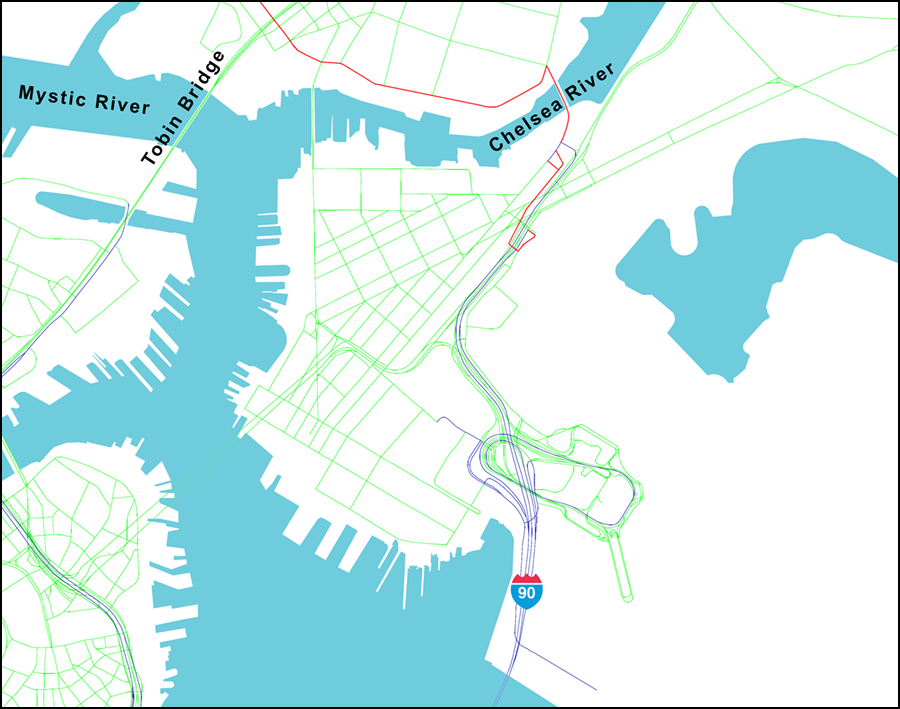
Figure 1
East Boston Haul Road to the Mystic River
Interstate I-90 ends in East Boston near Logan Airport. Roads in or near Logan Airport that connect with airfreight and related facilities are already designated for inclusion in the NHFN.
The recently completed East Boston Haul Road, highlighted in red, is a short distance south of the Chelsea River Bridge. MPO staff recommends that this new facility be incorporated into the NHFN and that the currently designated freight corridor on Bremen Street be removed.
Proposed entirely new CUFC mileage begins at the Chelsea River Bridge, which is used by about 2,600 heavy vehicles each weekday. It extends west through the Everett-Chelsea industrial area, and eventually connects with I-93 in Charlestown and the I-90 Turnpike in Allston. Figure 1 shows the route of the CUFC as far as the Tobin Bridge over the Mystic River.
Figure 2
Everett-Chelsea Industrial Area and Charlestown
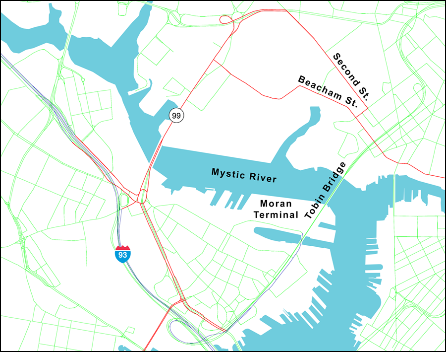
This CUFC continues north under the Tobin Bridge and enters the Everett Chelsea industrial area where it divides into two branches on Second and Beacham streets. On weekdays more than 1,600 trucks use the CUFC at the Tobin Bridge, and more than 1,600 trucks also use each of the two branches. The CUFC crosses the Mystic River on Route 99, the only lawful harbor crossing for hazardous cargoes.
Figure 2 also shows the various entry and exit ramps where this CUFC meets I‑93. At the bottom of Figure 2 the CUFC connects with an existing intermodal connector, which serves the auto import center at Moran Terminal in Charlestown.
Figure 3
Charlestown to the Turnpike
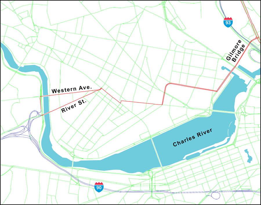
This proposed CUFC traverses the southern end of Cambridge, entering from Charlestown to the east on the Gilmore Bridge and connecting to Allston in the west, with the Western Avenue and River Street bridges crossing over the Charles River. About a thousand trucks travel between Cambridge and Allston at the western end of this corridor. Truck volumes are slightly less at the eastern end.
The western terminus of this proposed CUFC is Interchange 18 in Allston, allowing access to the I-90 Turnpike. Much of this route has signs indicating that it is as a truck route and it is available for transporting hazardous cargoes, which are prohibited in the highway tunnels in Boston and under Boston Harbor.
Figure 4
South Boston Waterfront
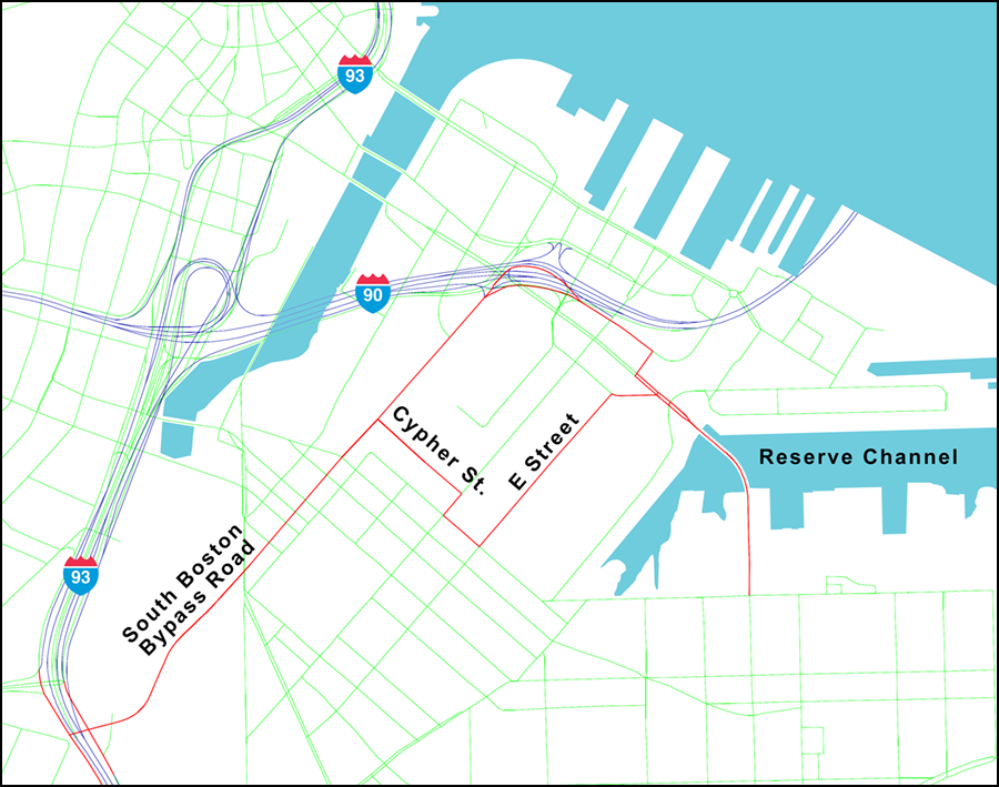
This proposed CUFC would connect industrial activity in the South Boston Waterfront with I-93. The South Boston Bypass Road connects with I-93, and is used by about 1,500 trucks each weekday. The eastern end of the proposed CUFC crosses the Reserve Channel to serve the Conley Container Terminal. About 1,000 trucks use this end of the proposed CUFC, most of which are ocean shipping containers.
A branch of this proposed CUFC uses Cypher and E Streets to allow trucks to avoid peak-period congestion where Bypass Road meets the I-90 ramps. Improvements to the Cypher/E Street route are being planned, which helps to justify its inclusion in the proposed CUFC system.
Figure 5
Fore River Shipyard
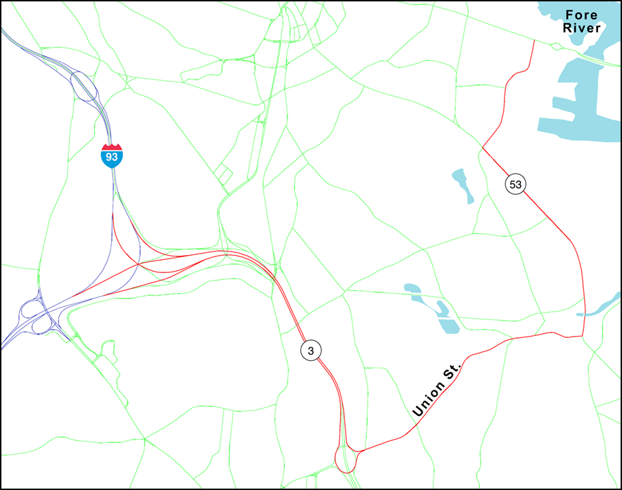
This proposed CUFC begins at the Braintree Split, where the limited-access Route 3 meets I-93 and the Southeast Expressway. The proposed CUFC includes Route 3 as far as Union Street, the first interchange toward the southeast. It follows Union and Commercial streets to Route 53, turns north and enters the industrial area on East Howard Street. The end of the CUFC would be at Route 3A at the western end of the new Fore River Bridge, now under construction.
Ship construction at the Fore River Shipyard in Quincy has long ceased, yet the shipyard, and its nearby area, continues to be used for industrial and logistic purposes. Active freight rail service complements and reinforces this district’s industrial nature.
Figure 6
Route 24
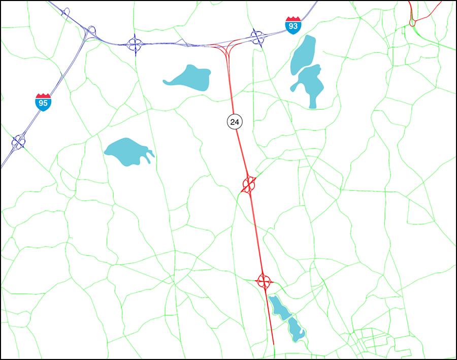
Route 24 is a heavily travelled limited access highway between I-93 in Randolph and the Rhode Island state line in Fall River. There are a large number of industrial sites and logistic operations such as warehouses, truck terminals, and motor pools located along the entire corridor.
This section of Route 24 is proposed as a CUFC; it includes mileage in Randolph, Stoughton, and Avon as far as Brockton in the Old Colony planning region.
Figure 7
Route 140
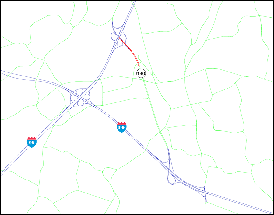
A large concentration of industrial and logistic activity is located directly east of the interchange of I-95 and I-495 on the boundary of Foxborough in the Boston MPO region and Mansfield in the Southeastern Region Planning and Economic Development District (SRPEDD). Active freight rail service complements and reinforces this area’s industrial nature.
This area is connected to the two interstate highways by Route 140. The portion of Route 140 south of I-95 in Foxborough is proposed as a CUFC.
Figure 8
Commerce Way in Woburn
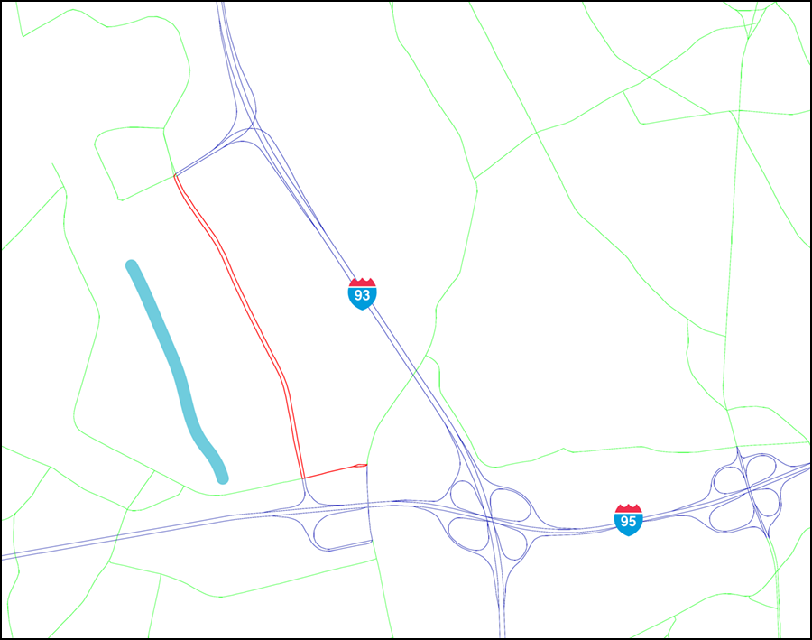
West of I-93 near its interchange with I-95 is an area with a large number of manufacturing, light industrial and logistic activities, some utilizing freight rail. Interchange 37C was added to I-93 in the 1990s to support continued industrial activity in this area and to serve the new Anderson Regional Transportation Center.
Commerce Way was built in conjunction with Interchange 37C, and connects this interchange with Interchange 36 on I-95 slightly more than a mile away. Commerce way between these two interchanges is proposed for CUFC designation.